Cycling in Rome: The Bike Routes That Really Work
In short. Rome is not a bike-friendly city, and it's best to say so right away: cobblestones that make your wrists vibrate, seven real hills, a patchy network of bike paths that breaks off where you'd need it, drivers who have never learned to live with people on bikes.
Rome is not a bike-friendly city, and it's best to say so right away: cobblestones that make your wrists vibrate, seven real hills, a patchy network of bike paths that breaks off where you'd need it, drivers who have never learned to live with people on bikes. Whoever arrives expecting Amsterdam is disappointed within the first quarter of an hour. There are, however, routes that work very well, some among the most beautiful in Europe for what they cross: dozens of kilometers along the Tiber without a traffic light, the paving stones of Via Appia Antica among the tombs, the Aqueducts Park at dawn, the Aniene valley that no tourist knows. This page explains which they are, what state they are in stretch by stretch, where they break off, how to take bikes on public transport, what the updated rules say on scooters and sharing, where bikes get stolen and how to lock yours, and how to leave Rome by train to ride to the sea, to the Castelli or to Lake Bracciano.
Why Rome is not a bike-friendly city
Rome has a network of bike paths that surveys put at a few hundred kilometers over a territory of almost 1,300 square kilometers, the largest municipality in Italy: very low density and, worse, fragmented into pieces that don't connect with each other. The good kilometers are concentrated in a few backbones, almost all along the rivers or inside parks, outside those you ride on the road with the cars.

The cobblestones: the first real obstacle
The paving of leucitite cubes that covers a good part of the historic center is problem number one for anyone cycling in Rome, more than traffic. On sampietrini in good condition you ride with constant vibration, on uneven sampietrini you risk a fall, especially with thin wheels or in the rain. The practical rule we give is simple: in the center, between Trastevere, Rione Monti and the Ghetto, the bicycle is for getting around, not for enjoying the route.
The seven hills are not a figure of speech
The Roman elevation change is real and whoever arrives from the plain underestimates it. The seven historic hills are modest rises, between 40 and 70 meters, but the ramps that reach them are short and steep: the climb of the Aventine from the Lungotevere, the one to the Janiculum from Trastevere, the Clivo di Scauro on the Caelian. Outside the historic hills the problem grows: Monte Mario exceeds 130 meters and is the highest point inside the city. A bike with suitable gearing is not a luxury: it is the difference between arriving and pushing by hand.
The patchy network: the structural flaw
The flaw that weighs most is not the scarcity of paths but their discontinuity. A typical Roman bike path starts inside a park, runs protected for two or three kilometers and ends against an intersection with no dedicated crossing, leaving the cyclist in traffic. The connections between one backbone and another are the missing link.
Traffic, coexistence and when to ride
On traffic, honesty requires saying that the average Roman condition is hostile: narrow lanes, double parking, public transport that pulls over without warning, scooters that overtake on both sides. There is, however, a Rome that is bikeable by the clock: early on Sunday morning the historic center and the Lungotevere are practically empty until 9:00, and in August the city empties out for weeks. In those windows the bicycle is the fastest vehicle there is.
The Tiber bike path, stretch by stretch
The Tiber bike path is the main backbone of the Roman network and runs on the floodplain, on the lowered level between the embankment wall and the river: the bike-touring sources that surveyed it on the ground credit it with about 32-35 continuous kilometers between Castel Giubileo to the north and the Mezzocammino bridge to the south, all inside the Grande Raccordo Anulare. It is the best stretch in the city for a structural reason: being below street level, it crosses neither a traffic light nor a car for dozens of kilometers. It is also, for the same reason, the most exposed to floods and to neglect of maintenance.
From Castel Giubileo to Ponte Milvio: the northern stretch
The northern segment, which descends toward Milvian Bridge, is the most recent and the least used: almost agricultural landscape and the most irregular surface of the backbone, among asphalt, dirt and wooden walkways that are slippery after rain. It is also the most isolated: for kilometers there is no passing traffic and no open businesses, so it is best ridden in full daylight and without counting on finding help in case of a flat.
From Ponte Milvio to the center: the most beautiful and most used stretch
Between Ponte Milvio and the Tiber Island the path gives its best: a surface largely paved with asphalt, a wide floodplain, and a route that passes below the Foro Italico with the Stadio Olimpico over your head, then under the Ponte della Musica, along the 19th-century embankment walls covered in murals, as far as the bend of Castel Sant'Angelo: about eight kilometers in the monumental heart of the city staying below the level of traffic.
The problems are two: the surface, worn under some bridges, and the crowding on weekends, when the floodplain becomes a path shared with runners, families and dogs. In summer a third is added: in the months when the river event between Ponte Sublicio and Ponte Sisto takes place, some segments of the quay are occupied by the festival's structures and passage is limited or diverted up to street level.
From the center to Marconi: the weak point
Downstream of the Tiber Island the picture worsens. The stretch that runs alongside Testaccio and reaches Marconi is the one that has suffered the most closures in recent years, because of quay subsidence and work on the bridges. The alternative is to climb back up to the Lungotevere, that is, to go from a protected bike path to a busy roadway with no reserved lane. Before planning a route to the south it's best to check the state of the stretch on the traffic information channels: closures are frequent and not always posted at the start of the ramp.
From Marconi to Mezzocammino: the southern stretch
Past the Marconi junction the path resumes along the Magliana as far as the Mezzocammino bridge, where it ends. It is less scenic, among sports facilities and wild greenery, but it is continuous and uncrowded, and for those who train it is the best in the city. After a flood a layer of silt stays for weeks and makes the ramps slippery.
From Mezzocammino to Ostia: the stretch that doesn't exist
Here we must say what many guides leave ambiguous: today there is no continuous, protected bike path from the center of Rome to the sea. The Tiber backbone stops at the Mezzocammino bridge and the continuation toward Ostia Antica and the coast takes place on roads open to traffic and on dirt stretches that are not always passable. The Rome-sea link has for decades been one of the projects announced and never completed, back on the agenda with the program of parks facing the river between Ponte Milvio and Ostia. Whoever wants to reach the Roman coast by bicycle has two honest options: the last stretch on the road, or the train to Ostia and a ride on the seafront only.
Three warnings apply to the whole floodplain. You get down only from ramps and stairways that are even kilometers apart, and not all can be ridden: with a heavy electric bike the operation is not trivial. After every flood the path stays impassable for days or weeks. And the floodplain is not lit: at night it is not advisable either for visibility or for personal safety.
The Appia Antica and the Caffarella
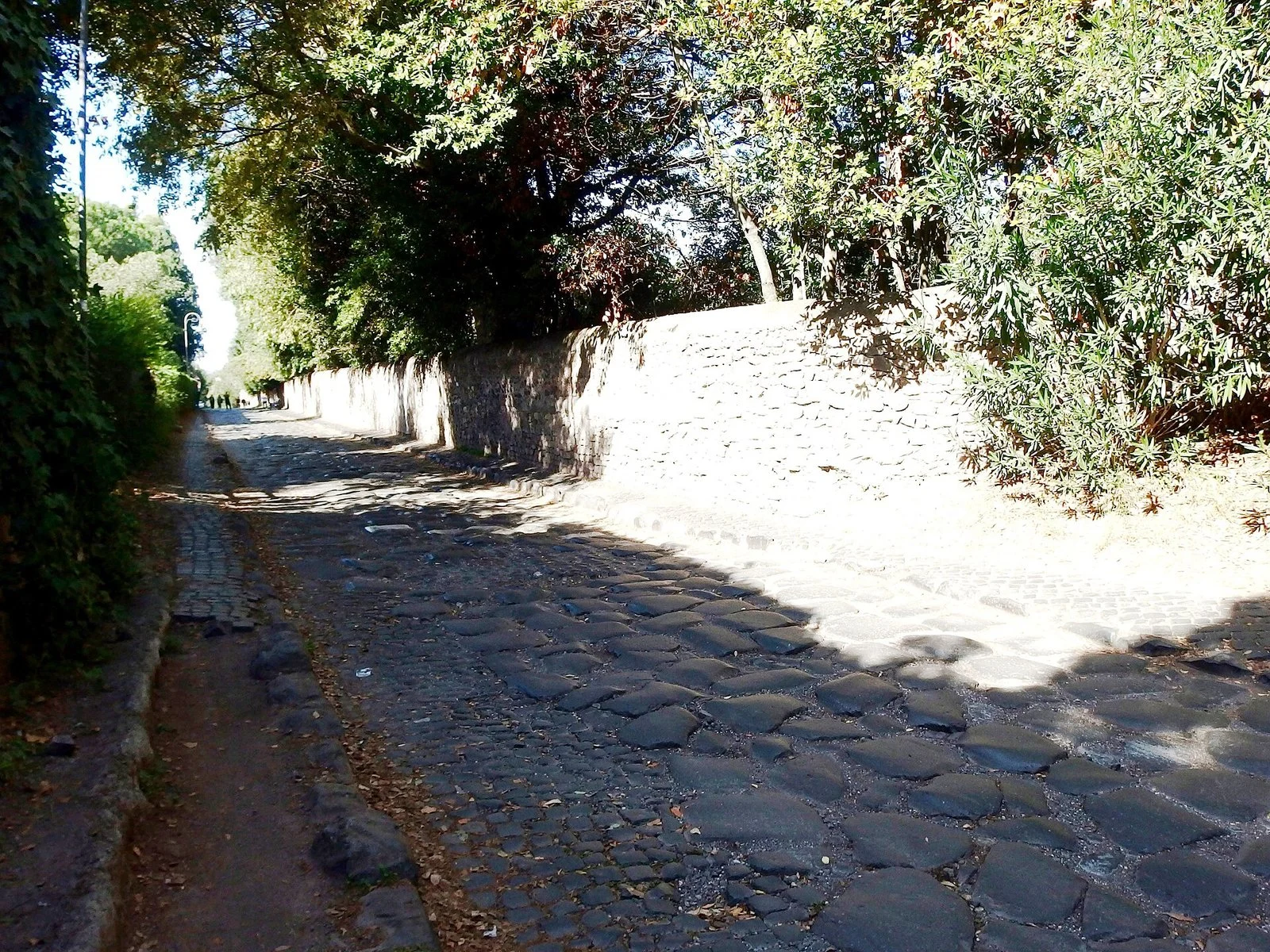
The Appia Antica Regional Park is always open and free, and Via Appia Antica can be ridden by bicycle for kilometers among tombs, Roman paving stones and tuff walls: it is the route we recommend first to those who have half a day. It is also the one on which the most inaccuracies circulate, because the surface changes radically from one stretch to the next and whoever arrives with the wrong bike spends the morning pushing.
The paving stones: ancient stones, not a bike path
Beyond the Mausoleum of Cecilia Metella the road keeps for long stretches the original paving, polygonal blocks of lava with wide joints and a surface polished by 2,000 years of traffic. On this surface a road bike is unusable and a city bike with thin wheels is uncomfortable to the point of danger: you need wide tires, better a mountain bike or a gravel bike. You ride at very low speed keeping to the packed-earth side strip where it exists, and in some spots you get off and walk.
The car-free Sunday and the rest of the week
On holidays car traffic on the Appia Antica is diverted by law enforcement in the stretch between Porta San Sebastiano and the intersection with Via delle Sette Chiese: it is the window in which the route gives its best. On other days the situation is different: the first stretch, the narrowest and most photographed, is open to local traffic, the side walls leave no escape route and cars pass at close range. The exact extent of the holiday diversion has been revised several times and must be checked on the park authority's website.
The Caffarella, the dirt-road alternative
Whoever wants to face neither the paving stones nor the traffic has a parallel route, for many Romans the most beautiful: the Caffarella Park, the agricultural valley between the Appia Antica and the Appia Nuova, crossed by wide, flat dirt roads among flocks, farmhouses, the nymphaeum of Egeria and the church of Sant'Urbano. It also suits those who ride little and connects to the Aqueducts Park and the Parco Appio. After rain the surface becomes muddy and in some places impassable.
What you meet along the route
The Appia backbone is an open-air museum and the bike lets you cover far more of it than you can on foot. In the first stretch you meet the Catacombs of San Callisto and the Catacombs of San Sebastiano, which can be visited only on a guided tour, farther south you reach the Villa of the Quintilii, paid and with a dedicated entrance. To the west are the Catacombs of Domitilla, and an overall picture is in the page on the catacombs of Rome. Returning toward the center you pass by the Baths of Caracalla, the Circus Maximus and the Colosseum: combined with the Acquedotti and the Caffarella it is the loop we recommend to those who have only one day. Practical note: none of these sites has adequate bike racks.
The Parco degli Acquedotti and the southeast quadrant
The Aqueducts Park is the area of the Appia Antica Park where the arches of the Claudian Aqueduct and the Acqua Felice run, crossed by wide, regular dirt roads that are ridden without technical difficulty. It is flat with very few obstacles, and it is the place we recommend to those who want to take children cycling without thinking about cars. The best light is that of early morning and the hour before sunset: it is also the time when the park is most frequented by runners, so it's best to keep a moderate speed.
How to get there by bike and public transport
The most convenient access from the center is the Giulio Agricola stop of metro line A, from which you reach the park in a few minutes of urban road, a second access is from Via Lemonia side. Those who ride can link Acquedotti, Caffarella and Appia Antica in a half-day loop that almost never touches busy asphalt. It is also the quadrant where a route along the Alexandrine Aqueduct has been planned for years, funded and designed but not completed: on the ground only part of it can be found.
The Aniene bike path
The Aniene bike path runs along the second river of Rome inside the Valle dell'Aniene Nature Reserve, and is the most underrated backbone of the city. The managing body describes a paved stretch built in the mid-2000s that starts from Via Salaria at Ponte Salario and follows the left bank toward the Nomentano district, and a second packed-earth route, the river area, which from the Nomentana continues toward Via Cicogna and Ponte Mammolo. Beyond that point, toward the quarries and the Raccordo, the surface requires a mountain bike.
What you cross
It is an urban and at the same time agricultural route, with reed beds, vegetable gardens, ancient bridges and industrial archaeology, which touches or skirts the Parco delle Valli, the Parco di Aguzzano and the Cervelletta Park, where a fortified farmhouse survives in the middle of the remaining countryside. Farther north extends the Marcigliana Reserve, with dirt roads that ride well but are not connected to the city network, and the Nomentum Reserve.
The limits to know
The Aniene bike path has three recurring problems: the two stretches don't form a single well-signed route and the links can be found only by knowing them, maintenance is irregular, with vegetation invading the path in the hot season, some segments are isolated and little used, so the floodplain rule applies, full daylight and possibly company.
Historic villas and urban parks
The most reliable network in Rome for those who ride is not made of bike paths but of parks: green enclosures where cars don't enter and the avenues are wide enough for a real ride. They are also the places where it's best to start.
Villa Doria Pamphilj, the largest
With almost 180 hectares, Villa Doria Pamphilj is the largest public park in Rome and the best place in the city for a long ride without cars: avenues of asphalt or compacted gravel, manageable elevation change, loops of different lengths. Two warnings: some areas are off limits to bicycles and the signage is not always clear, and on weekends the central avenues are very busy.
Villa Ada and the north
Villa Ada is the second great park of the city, with avenues and paths suited to the bike, including a part with a natural surface and demanding ups and downs, and it connects to the Salaria route and from there to the Aniene. In summer it hosts a music festival and the cinema arena inside Forte Antenne: on show nights some areas are fenced off and bike passage is limited.
Villa Borghese, Villa Torlonia and the green center
Villa Borghese is the most visited urban park and works for a short ride, but it is crossed by roads open to traffic and on peak days it is saturated with pedestrians and rental vehicles: it is not the place to rack up kilometers, it is the place to link two stops. The same goes for Villa Torlonia and for Villa Sciarra on the Janiculum, which has narrow avenues and stairways. Inside Villa Borghese are Piazza di Siena and the Temple of Aesculapius, in front of which it's best to get off the saddle.
Monte Mario, the Pineto and the northwest reserves
West of the Tiber the Monte Mario Nature Reserve offers wooded trails with serious gradients, for mountain bikes: at the top you reach the Astronomical Observatory and the viewpoint. A little farther south the Parco del Pineto has gentler dirt roads and a loop anyone can ride, to the north the Insugherata Reserve keeps an almost rural environment but with poorly marked trails. The common problem is the usual one: you ride very well inside, and you come out in the middle of traffic.
The parks of the eastern quadrant: Tor Tre Teste and Centocelle
In the eastern quadrant the system of parks between Villa Gordiani, Tor Tre Teste and the former Centocelle airport has internal bike routes of uneven quality, with stretches of good asphalt and stretches where the path is overgrown with grass. The link westward on the Prenestina and northward on the Nomentana has been built only in segments: the idea of a continuous Nomentana-Tor Tre Teste backbone remains on paper more than on the ground. A little farther east is also the Parco della Mistica, with wide dirt roads and very few visitors.
The EUR and the south quadrant
The EUR is, by how it was designed, the Roman neighborhood where the bicycle works best: wide, straight streets, generous sidewalks, regular blocks, an urban layout from the 1930s that doesn't know the alleys of the center. It has a significant slope between the upper part, around the Palazzo della Civiltà Italiana and the basilica of Santi Pietro e Paolo, and the lower part around the little lake. Around the lake and in the adjacent public park you ride in a protected setting, a good destination for an outing with children.
From the EUR to the sea and toward Castelporziano
From the EUR the routes to the south start: Via Cristoforo Colombo, a fast-flowing road and not a bike route, and secondary routes toward the Laurentino-Acqua Acetosa Reserve and the Decima Malafede Reserve, the largest of the Roman protected area. Toward the sea you meet the perimeter of the Tenuta di Castelporziano, presidential and not freely accessible.
The Ostia seafront
The seafront between Ostia Lido and Castel Fusano is instead a usable and flat bike route, suited to a half-day outing for those who arrive by train. To the south you reach the Castel Fusano pine forest and the stretch of coast at Capocotta. The medieval village of Ostia Antica and the excavations can be reached by bike from the station in a few minutes: inside the excavations, however, the bicycle is left at the entrance.
The consular roads: how to leave Rome
The ancient consular roads remain the only routes that truly lead out of the city, and on each the situation is different. The Appia Antica is the only one on which you leave in an almost intact setting, but beyond the Grande Raccordo Anulare it becomes patchy and partly unmaintained. The Appia Nuova and the Tuscolana toward the Castelli are busy roads with growing gradients, passable by trained cyclists at the right hours but not by those without traffic experience. Cassia and Flaminia have narrow stretches with blind curves, Nomentana and Tiburtina flow well but have heavy truck traffic. The same criterion applies on all: leave early in the morning, prefer holidays, rear light on even in daytime, high-visibility clothing, and parallel secondary roads where they exist.
Via Francigena and the walking routes
Whoever wants a multi-day itinerary has a structured alternative to the consular roads: Via Francigena in Lazio, which enters Rome from the north and is signposted, largely on dirt roads and low-traffic roads. It must be said that it was born as a walking route and that several stretches require a mountain bike or provide cycling variants distinct from the pedestrian ones: the route must be studied beforehand and not improvised.
The GRAB: where it really stands
The GRAB, Grande Raccordo Anulare delle Bici, is the bike-and-pedestrian ring that is supposed to link the monumental center, Appia Antica, the eastern quadrant and the Tiber in a single circuit: the official and project sources give a length between about 44 and 50 kilometers, and the figure varies with the version of the route considered, so we report both. The works are divided into lots awarded at different times and proceed by segments.
What it means for those who ride today
The substance, at the date we write, is that the GRAB cannot be ridden as a continuous ring: some stretches are completed and inaugurated, others under construction, others still only designed. You can ride the individual open segments, which largely coincide with itineraries already described here. The state of progress changes from month to month and must be checked on the channels of the city and the mobility agency.
Bike sharing and scooters: the updated rules
In Rome free-floating bike sharing and scooter rental are regulated by time-limited municipal authorizations, and in summer 2026 the Capitoline administration approved a new framework of rules, in force when the previous authorizations expire. The resolutions show a cap on the number of operators for each service, strict numerical limits in the central areas and in the limited traffic zone of the Tridente, minimum density requirements in the peripheral quadrants so that the service does not concentrate only where it pays, minimum distances between vehicles of the same operator, reduced fares for holders of the annual public transport pass and checks with fines and removals charged to the operators.
Scooters: what is mandatory today
The national rules on scooters have changed profoundly. The helmet is mandatory for all riders, without distinction of age, since the reform of the highway code that came into force on December 14, 2024. The minimum age is 14. Speed is limited to 20 kilometers per hour on the road and 6 in pedestrian areas. Riding is forbidden on sidewalks, on extra-urban roads and on those with a limit above 50 kilometers per hour, and is allowed only where bicycles are allowed. The vehicle must have turn signals and lights.
License plate and insurance: the part that changes fastest
On the identification plate and on third-party liability insurance the situation has been postponed several times and must be checked at the time you read this. The picture emerging from official and specialist sources in 2026 shows the plate requirement from mid-May 2026 and the insurance requirement from mid-July 2026, with a transitional period before penalties. These are dates that have already slipped several times and mainly concern private vehicles: for rental scooters the obligations fall first on the operator, which does not relieve the rider of responsibility for conduct.
Why we advise against the scooter on cobblestones
An observation that never appears in promotional materials: the electric scooter, with small rigid wheels, is the worst possible vehicle on Roman paving. On uneven sampietrini the wheels get caught in the joints, balance is lost in an instant and falls are frequent and serious, especially downhill and on wet ground.
Taking your bike on the metro, tram, bus and trains
Taking a bicycle on public transport in Rome is possible, but the rules change from operator to operator and are more restrictive than many believe, particularly for electric vehicles: it is the part of planning that we recommend always checking on the operator's website before leaving.
Folding bikes: the solution that solves almost everything
Folding bicycles, within folded dimensions given by the municipal operator as about 110 by 80 by 40 centimeters, are allowed on the metro and the surface network every day and without time restrictions, as hand luggage. This is the reason why people who live in Rome and use the bike for the last mile almost always choose a folding one: it solves intermodality and theft at the root, because the bike goes into the office with its owner.
Non-folding bikes on the metro, bus and tram
For non-folding bicycles the conditions are more complicated. On the surface network transport is allowed only on lines served by vehicles at least 12 meters long equipped with the space reserved for people with disabilities, and on trolleybuses. On trams it is limited to low-floor vehicles, so only on some lines and not always. On the metro it is allowed as hand luggage with some stations excluded on line A and with the obligation to use elevators where there are any. There is only one space per vehicle and priority goes to whoever needs the reserved spot. Those without an integrated pass must get an additional travel ticket.
The critical point: electric bikes and scooters
Here something must be said that surprises many: the regulations of the Roman and regional public transport operators exclude battery-powered micromobility vehicles, and this includes pedal-assist bicycles and electric scooters, even folding ones. The stated reason is the fire risk of lithium batteries in a confined space. Enforcement of the checks has been discontinuous, with periods of tolerance and periods of crackdown, but the formal ban exists: whoever counts on taking an e-bike on the metro or on the railway to the coast risks being left behind.
Regional trains
On the regional trains of Lazio a non-folding bicycle is carried in the equipped cars with a dedicated supplement, valid for the whole day, or with annual passes, folding ones, within the dimensions given by the carrier, travel free as luggage. The amounts and conditions are set by the carrier and may vary: they must be checked on the official website at the time of purchase, and for this reason we do not give a figure. Not all trains have equipped cars and at peak hours the bike space can be full. For the general picture on transport we refer to the page on how to get around Rome.
The electric bike and the seven hills
Pedal assist radically changes the experience of Rome, for a topographic reason before a sporting one: with a motor helping, the ramps of the Aventine, the Janiculum, Monte Mario and the climb back from the lower EUR stop being a problem. For those who have two or three days and want to link distant neighborhoods it is the vehicle we recommend without hesitation. The drawbacks are three: the weight, which makes it tiring to push the vehicle on the access stairs to the floodplain, the formal ban on carrying it on public transport, which eliminates intermodality, and the value, which makes theft a costlier risk. Public charging points are not widespread: it's best to start with a full battery and keep a margin for the return.
Where bikes get stolen and how to lock yours
Theft is, along with the cobblestones, the reason many Romans stop using the bicycle: urban cyclists' associations describe it as the main deterrent to daily use, more than rain and traffic. There is no official and complete statistic on bicycle theft in Rome, because a substantial share is not reported: anyone offering a precise number is estimating, and we don't. The risk is concentrated near stations and interchange hubs, in nightlife areas, in front of universities and in unsupervised apartment-building courtyards, a classic target precisely because they are considered safe.
How to really lock it
The practical rules are few and they work. Use a rigid U-lock, not a steel cable, which is cut in a few seconds. Lock the frame, not just the wheel, to a fixed element that cannot be lifted over: a tall pole, an anchored rack, never a sign that slides off from the top. Remove the saddle and lights when they are removable, and choose a visible and busy spot. And photograph the bicycle noting the frame number, because without that number a report is almost useless and a recovered bike cannot be returned. There are private national registers that law enforcement can consult: operation and costs vary, and we don't list any here. In case of theft the report must be filed anyway.
Workshops, community bike workshops and repairs
Rome has a network of bicycle workshops unevenly spread, concentrated in the neighborhoods where the bike is used most: the Trastevere-Testaccio-Ostiense quadrant, the Pigneto and the eastern quadrant, the north between Flaminio and Salaria. We don't give names: a list of shop signs goes out of date within months. We give the criteria.
How to choose a workshop
A serious workshop does three things: it tells you the cost before working, it distinguishes between what is needed and what can wait, and it returns the replaced parts if you ask for them. Anyone who doesn't give an estimate before taking things apart should be left where they are. For pedal-assist bicycles, electrical diagnostics require specific equipment that not all general workshops have: it's best to ask first.
The community bike workshops
Alongside commercial workshops there is in Rome a network of community bike workshops, born inside social centers, self-managed spaces and neighborhood associations, which work on a different principle: they don't repair for you, they teach you to repair, providing tools, salvaged parts and someone who explains. They are spaces with free participation or a voluntary contribution, with limited and variable hours that must be checked case by case. For a day ride it's best in any case to bring an inner tube, tire levers, a pump and a multi-tool: on the dirt roads of the Appia and on the floodplain flats are frequent.
Groups, associations and group rides
Rome has an urban cycling scene livelier than it seems. For those who arrive from elsewhere or don't feel like riding alone in traffic, joining a group is the simplest way to learn the right routes and the shortcuts that no map shows.
What you find in the city
In Rome there are local branches of the national federation of cycling environmentalists, which organize Sunday excursions in the city and out of town with guides, and cycle-activist groups that deal with road safety and monitoring of the network. Then there is the tradition of Critical Mass, the self-organized group ride with no preset route, present in the city for decades: free and open events, with variable dates and meeting points. Some have a cultural rather than sporting character: bike rides to film locations, itineraries on the street art of the outskirts, routes on the memory of the 20th century. Other free ideas are on the page about free Rome.
Train plus bike: day trips outside Rome
The best way to use the bicycle in Lazio is not to ride out of Rome, it is to leave by train and ride at the destination: in an hour you go from urban traffic to roads you can ride. The warnings already written apply: bike supplement, equipped cars not present on all trains, ban on carrying electric vehicles on the operators that provide for it.
Ostia and the coast
The most immediate destination is the coast: you arrive at Ostia Antica for the excavations and the village, or at Lido Centro for the seafront, from which you ride on the flat to the Castel Fusano pine forest. Watch the point already noted: the line serving the coast has its own regulation and restrictions on electric vehicles. Going up the coast you reach the Lido di Maccarese and Fregene, with flat country roads among the reclaimed land.
The Castelli Romani: the trip that requires legs
The Castelli Romani are the most beautiful destination and the most demanding: you climb to the rim of a volcanic crater and the elevation change is real, with gradients that in several places exceed 10 percent. The stations of Frascati, Albano, Marino and Velletri shorten the worst part. At altitude you ride on the road that goes around Lake Albano touching Castel Gandolfo, and descend toward Nemi, Genzano, Ariccia and Grottaferrata. The descent to the lake is steep in both directions and must be tackled with brakes in order. The ride should be planned around train times and bike spaces, not on improvisation.
Lake Bracciano
Lake Bracciano is, for those who ride, the most balanced day trip out of town in Lazio: the circuit of the lake runs for about 50 kilometers on roads with moderate traffic and with limited elevation change compared with the Castelli, and touches Bracciano with its castle, Anguillara Sabazia and Trevignano. The area is protected by the Bracciano and Martignano Park, and to the north are the wetlands of the Pantane di Trevignano. On weekends there are so many cyclists on this line that they fill the bike spaces: it's best to leave early.
Toward the north and the east
North of the lake open the Veio Park, with dirt roads among the ravines, and the Monterano Reserve. On the coast you reach by train Ladispoli, the Santa Severa Castle and Cerveteri with its Etruscan necropolises. To the east you reach Tivoli, where however the elevation change from the station to the center is immediate and steep and the Parco di Villa Gregoriana cannot be visited by bicycle, being a route of stairs and steep paths.
The Appia toward the south
Whoever wants to follow the Appia beyond the municipal territory finds an itinerary of great historical interest but of irregular quality: preserved stretches alternate with interruptions, private properties and segments on busy roads. Usability by bicycle is not uniform and must be studied in advance.
Where to stop to eat along the route
A half-day ride includes a stop, and on this we give criteria and not shop signs: a list of places goes out of date in a few months. The simplest rule that works in Rome is to look at who is sitting at the tables and in what language they order.
The signs to recognize
There are clues that almost always work in the field. The lady rolling out fresh pasta in the window or in the street is a scenic lure, not an index of cooking. The menu with photographs of the dishes is the sign of a place calibrated to passing trade. The tout at the door inviting you to sit is a sufficient reason to keep walking. The place open from morning to night with no kitchen break doesn't have a kitchen in the sense that whoever cooks understands it. And the places immediately in front of the most photographed monuments tend to adjust the price to the tourist in front of them, with items without prices and different price lists between the indoor room and the outdoor tables. Even the chains repeated at several points of the center, same sign and same menu everywhere, deserve just one remark: Romans don't go there.
The criterion for those who ride
Whoever goes by bicycle has an advantage: five minutes of riding from the monument is enough to enter a neighborhood where the ratio between price and quality changes radically. Along the Appia and in the Caffarella it's best to bring your lunch, because inside the parks the options are few and seasonal. In the neighborhoods, the local markets remain the most reliable place: we talk about them on the page on the markets of Rome, and the general theme of how to choose is covered in where to eat in Rome. Whoever prefers a ready-made selection can consult Daniele Dezi's personal list on Google Maps, curated and not sponsored.
Rules of the road and safety
In Italy the helmet is not mandatory for those who ride a bicycle, unlike what applies to electric scooters, but we recommend it without reservation on any route that touches roads open to traffic or steep descents. Lighting devices and reflectors are, however, mandatory and fined at night or in poor visibility.
Where you can ride and where not
Bicycles can circulate in the limited traffic zones of the historic center, and it is one of their main advantages in Rome: where the car doesn't enter, the bike passes. The picture of limitations for motor vehicles is on the page about the ZTL of Rome. You don't ride on sidewalks, except where a marked bike-and-pedestrian route exists, in crowded pedestrian areas it's best to get off and walk.
The unwritten rules that matter most
Three habits reduce risk more than any device. Keep your line a good meter from parked cars, so as not to end up against a door that opens: it is the most frequent accident in the narrow streets of the rioni. Never pull up on the right side of a long vehicle stopped at a traffic light, because when it turns the cyclist ends up in the blind spot. And make yourself seen: taking your share of the lane when needed is safer than squeezing against the edge. Those with accessibility needs will find guidance on the page about accessible Rome.
When it's best to give it up
There are conditions in which in Rome the bicycle is not the right choice, and we say so openly: in the rain on the sampietrini, at rush hour on the big arterial roads, in August in the middle hours, and at night on unlit river routes. In those cases the page on Rome when it rains collects the indoor options.
Frequently asked questions about cycling in Rome
Is Rome a city suited to the bicycle?
Rome is not a bike-friendly city in the sense that Amsterdam or Copenhagen are: the network of paths is patchy, the historic center is covered in sampietrini that make riding tiring and slippery in the rain, and the elevation change of the hills is real. There are, however, protected routes of excellent quality, almost all along the rivers and inside the parks, that are worth the trip.
How long is the Tiber bike path and does it reach Ostia?
The Tiber bike path covers about 32-35 continuous kilometers between Castel Giubileo and the Mezzocammino bridge, all inside the Grande Raccordo Anulare, and does not reach Ostia. The bike link between Rome and the sea has never been completed: beyond Mezzocammino you continue on roads open to traffic and on discontinuous dirt stretches.
Can you ride a bike on the Appia Antica?
You can ride a bicycle on the Appia Antica and access to the Appia Antica Regional Park is free and open, but the Roman paving beyond the Mausoleum of Cecilia Metella requires wide tires and very low speed. On holidays car traffic is diverted in the stretch between Porta San Sebastiano and Via delle Sette Chiese, and that is the best window to ride it.
Can you take a bicycle on the metro in Rome?
Bicycles are allowed on the Rome metro as hand luggage, with some stations on Line A excluded, one space available per car, and an obligation to use elevators where they exist. Anyone without an integrated pass has to buy an additional ticket. Folding bikes within the dimensions set by the operator travel with no time restrictions on the whole network.
Can you take electric bikes on public transport in Rome?
Pedal-assist bicycles and electric scooters are excluded by the transport regulations of the Rome and regional operators, which ban battery-powered micromobility vehicles because of the risk posed by lithium batteries. Enforcement has been inconsistent over the years, but the formal ban exists and you should check it in the operator's regulations before counting on it.
Is a helmet mandatory on a bike and on an electric scooter in Rome?
On a bicycle, a helmet is not required by law in Italy. On an electric scooter it is mandatory for all riders, with no distinction by age, since the road code reform in force from December 14, 2024. Scooters are also subject to a limit of 20 kilometers per hour on the road, a minimum age of 14 and a ban on sidewalks.
Can you ride the GRAB, the bike ring road?
The GRAB can't be ridden today as a continuous loop. The project, given by sources as between 44 and 50 kilometers long, is divided into lots and moves forward in segments, with stretches that are open, stretches under construction and stretches that are still only planned. You can ride the individual segments that are already finished, which for a large part coincide with the Tiber floodplain and the Appian Way.
Who wrote this page
This page is edited by the team at Tour Leader Pro, the Rome-based project office that designs and coordinates visits, itineraries and cultural events in Rome and Lazio. Hours, fares and access conditions given here were checked on the publication date against the official sources named in the text. It's worth rechecking them before you leave, because they change often. If you find outdated information, let us know.
If you are building a two-wheel itinerary in Rome, lining up the Tiber floodplain, the Appian Way and the parks of the southeast quadrant, and you have to fit together train times, bike spaces and visits to book, you will find planning tools on Tour Leader Pro, especially useful when the group is large.
For a broader picture of regional rail connections and of the destinations in Lazio you can reach by combining train and bicycle, from Lake Bracciano to the Castelli Romani, Italy Planner is a good resource.