Parco delle Valli – Conca d’Oro
In short. Parco delle Valli is the large green space that follows the course of the Aniene in the northern quadrant of Rome, between the Conca d’Oro neighborhood and the Monte Sacro hill, within the territory of the III Municipio.
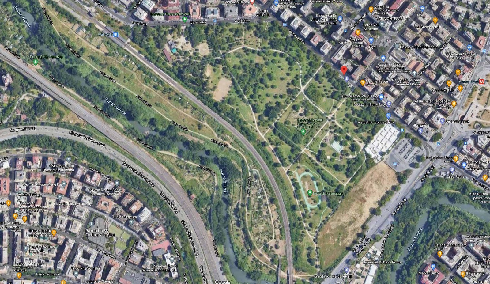
Parco delle Valli is the large green space that follows the course of the Aniene in the northern quadrant of Rome, between the Conca d’Oro neighborhood and the Monte Sacro hill, within the territory of the III Municipio. It isn't a historic villa with gates and statues, nor a garden designed by an architect: it is a long, narrow river strip, reclaimed from countryside and neglect, which today works as a neighborhood park for tens of thousands of people and at the same time as an ecological corridor for the river. The park is part of the Valle dell’Aniene Nature Reserve, the protected area that follows the last Roman stretch of the river before its confluence with the Tiber, and it is owned by the City of Rome. The green area runs from the Ponte delle Valli up to the level of Via dei Prati Fiscali, just past the Val d’Ala railway station, and the people who live here call it, without too much ado, the big park of the Municipio. Visitors from outside, on the other hand, often don't even know it exists: it doesn't appear in guidebooks, it has no ticket, it has no monumental entrance to photograph. Yet it is one of the places I most gladly recommend to anyone who wants to understand how Rome lives outside the historic center.

Where Parco delle Valli is and how to really get there
The geography needs explaining properly here, because the park doesn't have a compact shape and doesn't have a main entrance. Picture a green strip that follows the river: on one side the Monte Sacro hill with its Città Giardino, on the other the dense fabric of Conca d’Oro and Prati Fiscali. The park fills the valley floor in between, that is the depression that Romans call, precisely, le Valli, and which for centuries was farmland, vegetable gardens, reed beds and then no man's land. The entrances are many and almost all informal: gaps that open onto neighborhood streets, ramps, small staircases, stretches of sidewalk that end directly on the lawn.
By metro: the B1 branch and the Conca d’Oro stop
The easiest way to arrive without a car is the metro. The B1 branch goes up the northern quadrant, splitting from Line B at Bologna and continuing toward Annibaliano, Libia, Conca d’Oro and Jonio. The stop that serves the park is Conca d’Oro, and it is no accident that it bears the same name as the neighborhood and the little market: the exit leaves you a few minutes on foot from the southern edge of the park, with the path that descends toward the valley floor. Those arriving from the center take a little more than a quarter of an hour from Termini station, counting the change at Bologna. From Jonio station, which is the terminus, you reach instead the easternmost part of the green zone, the one toward Viale Jonio and Tufello, but the walk turns out longer and less intuitive.
By train: Val d’Ala station and the northern belt stops
The western edge of the park comes right up against the railway, and the reference station is Val d’Ala, on the line that goes up toward Nuovo Salario, Fidene and Settebagni. It is a small stop, of the kind that serves the neighborhood's commuters and that many Romans have never used, but it is the only point where the train practically drops you on the edge of the green. Whoever gets off here finds themselves a step away from the limit toward Via dei Prati Fiscali. The schedules of these suburban lines change with the seasonal timetable changes and should be checked the same day, because in some time bands the minor stops are skipped.
By bus and by bicycle
The surface lines that touch the perimeter are quite a few and serve the neighborhood's major axes: Via dei Prati Fiscali, Viale Jonio, Via Nomentana, Viale Adriatico, Via Val d’Ala. None of them enters the park, obviously, but all of them drop you within walking distance. Those who get around by bicycle have the best situation of all, because the park is crossed by two bike paths: one connects toward Villa Ada, the other leads toward Via Nomentana. They are the two axes that make Parco delle Valli something more than a neighborhood garden, because they place it in a network that lets you travel long distances without mixing with traffic.
By car and the parking problem
Those who arrive by car have available, according to local sources, a parking lot of more than 200 spaces built to serve the citizens on the Conca d’Oro side. On weekdays it works well. On little-market days and on spring weekends it fills up early, and whoever arrives after mid-morning ends up circling for a long time in the neighborhood streets, where parking is contested among residents, shop customers and visitors. The practical advice is to treat the car as the last option: here the metro works, and the park is enjoyed much more by arriving on foot on one side and leaving from the other.
What Parco delle Valli really is: a neighborhood park inside a reserve
A distinction is needed here that escapes many people. Parco delle Valli isn't an autonomous administrative entity: it is a portion, the most urban and the most frequented, of a larger protected area that follows the course of the Aniene within the municipal territory. This means that two different logics coexist on the same piece of land. On one side there is the logic of the urban park, with the children's play equipment, the drinking fountains, the fields, the paved paths, the trash cans, the benches: everything that a resident population needs when it comes down into the street in the evening and on weekends. On the other there is the logic of the nature reserve, which reasons in terms of river habitat, riparian vegetation, animal species that use the river corridor to move between the Roman countryside and the city center.
Ownership, management and the role of RomaNatura
The park is owned by the City of Rome, while the management of the protected area is entrusted to RomaNatura, the regional body that deals with safeguarding and promoting biodiversity in the protected green and marine areas of the Roman territory. According to what is reported, management has been in the hands of RomaNatura since 2008. Before that handover the story had been much more complicated, and it is worth telling because it explains why this park exists.
A large part of this area, in fact, was privately owned land. There were building projects on that land: apartment buildings, commercial activities, the classic filling of an urban void that in Rome has been the rule for decades. The neighborhood's residents protested, organized and managed to block the transformation. It is a story that repeats itself in many Roman peripheries, and almost always ends badly for the green. Here instead the valley floor stayed free and, over time, was brought into the system of protected areas. Whoever walks today on the main lawn is walking on a piece of city that could have been concrete and didn't become so because someone stood in the way.
Cleaning, supervision and rules
Day-to-day management is split among different parties, and this too needs explaining because it is the reason why whoever wants to report a problem often doesn't know whom to turn to. The cleaning of the area appears to be entrusted to the company that holds the contract for the Conca d’Oro little market: citizens can contact that company directly, by phone or email, to report abandoned waste or situations of decay. Enforcing the rules of the area's regulations, on the other hand, falls to the park rangers, who operate from the station of the Marcigliana Nature Reserve, a little further north.
This split has a practical consequence worth knowing: the park rangers don't staff Parco delle Valli continuously, because they cover a much larger territory. The result is that respect for the rules, here, depends in large part on the civic sense of those who use the place and on the social pressure of the residents, who are many and who know the park meter by meter. Visitors from outside will do well to behave accordingly: dogs on a leash where required, no fires, trash taken away, bicycles at a reasonable speed on paths shared with pedestrians.
The park's project and the battle that made it possible
The story of Parco delle Valli is a textbook case of recent Roman urban planning, and it is worth telling at length because it helps to understand everything else: why the park has this shape, why some facilities work and others don't, why the tone of the place is so different from that of a historic villa.
From agricultural valley floor to building pressure
Until the middle of the 20th century this was countryside. The Aniene flowed between meadows and cultivated fields, farmhouses dotted the valley, and the urban fabric of Rome ended much earlier. The construction of the Città Giardino Aniene, in Monte Sacro, and then the expansion of Conca d’Oro, Prati Fiscali and Tufello brought tens of thousands of residents up against the river over the span of a few decades. The valley floor, however, remained largely unbuilt: partly because of the alluvial nature of the ground, partly because hydraulic restrictions made it complicated to build too close to the watercourse, partly through simple inertia.
The mobilization of the residents
What happened is the part of this story I like best. The residents didn't limit themselves to signing a few petitions: they symbolically occupied the space, cleaned it, organized activities in it, made it visible. It is a strategy that in urban planning has a precise name, and it consists of demonstrating with facts that an urban void already has a public function. When an area is used daily by hundreds of people, changing its designated use becomes politically much more expensive.
The park as school and as gym
The idea that guides the management today, at least in its declared intentions, is to turn Parco delle Valli into a large outdoor school and a gym for getting to know nature in its different aspects. The environmental education activities are organized by the Conca d’Oro volunteers and are free: guided outings, recognition of trees and birds, cleanup days, workshops for the neighborhood's schools. The logic is simple and I share it: a kid who has learned to recognize a poplar and a gray heron in the park below his house is unlikely to treat it afterward as a dump.
The calendar of these initiatives isn't fixed and doesn't follow a rigid seasonality: the activities are scheduled as they come, often with little notice, and communicated through the channels of the neighborhood associations. Those who want to take part will do well to look for local announcements in the preceding days, because many of these days have no promotion outside the neighborhood. To get oriented on the general picture of Roman initiatives you can start from the events page.
A curiosity about Parco delle Valli - Conca d’Oro
The curiosity concerns the name, and almost nobody notices it. Conca d’Oro isn't an ancient place name or a poetic invention of the building trade of the 1960s: it is the name of an old agricultural estate that occupied this part of the valley floor. The word conca (basin) describes exactly the morphology of the place, that is the closed depression between the Monte Sacro hill and the rises toward Prati Fiscali. The adjective oro (gold) refers to the color of ripe wheat, because it was grown here. The name, in short, is the oldest thing in the neighborhood: it survives the countryside that generated it and the buildings that replaced it, and today it identifies a metro stop, a little market, a street and a park.
There is a second layer of curiosity, which concerns the name of the hill next door. Monte Sacro comes from the Mons Sacer of Roman tradition: the little hill on the right bank of the Aniene where, according to the account handed down by ancient authors, the plebs withdrew during the first secession, leaving the city and forcing the patricians to negotiate. It is an episode that modern historiography considers in large part legendary in its details, but the place name remained and gave its name to the neighborhood, to the Città Giardino and to an entire piece of 20th-century Rome. Walking along the Aniene here means walking at the foot of a hill that bears the name of the first general strike in European history, as the Romans told it to themselves.

What the park offers: facilities, services and spaces
Let's get concrete. According to the data reported by local sources, the green area of Parco delle Valli extends over a surface of about 20 hectares, which become 21 if you also count the gully of the Aniene river. Within this perimeter, very different facilities coexist, some in excellent condition and others not. The list that follows takes up what is documented about the park, with clarifications useful to anyone visiting it for the first time.
- Two bike paths. One connects toward Villa Ada, the other reaches Via Nomentana. They are paths shared with pedestrians on some stretches, so speed should be kept low.
- A senior center. A meeting point where, with the support of the Conca d’Oro volunteers and other associations, people of the neighborhood can take part in free social and cultural activities: basic computer courses, cultural meetings, nature initiatives, light sports activities.
- A bocce court connected to the senior center. It should be noted that, according to what is reported, the senior center and the bocce court are not currently in use because of a fire that destroyed their structures.
- Three drinking fountains. Few for the size of the park, but precious in summer.
- The Conca d’Oro little market, which occupies a dedicated area and is an integral part of the life of the place.
- A play area for children with a skating rink and games of different kinds.
- Equipped picnic areas.
- A few gazebos, useful as shelter from the sun and in case of sudden rain.
- A parking lot of more than 200 spaces serving the citizens.
The sports practiced here
Parco delle Valli is, first of all, a neighborhood sports park. Running is the dominant activity: the long, flat paths of the valley floor are ideal for those who train over medium distances, and in the early hours of the morning and in the late afternoon the park fills with runners. Cycling comes right after, favored by the two bike paths. Then there are soccer and volleyball, practiced both on the equipped spaces and, much more often, on any piece of lawn flat enough.
The CONI sports and play area
An important passage in the recent history of the park concerns the sports and play area built with CONI: it appears to have been inaugurated on May 4, 2018, and the promotion of the project is attributed to the social promotion association Amici di Conca d’Oro. It is a concrete example of what I said before: things, in this park, happen when someone from the neighborhood pushes them. They don't come from above through ordinary planning, they come because a group of residents knocks on the right doors for long enough.
The Conca d’Oro little market
The little market deserves a paragraph of its own, because it is the reason why part of the visitors come here. It is a market that occupies a dedicated area inside the perimeter and that has, as I said, a management role too: the company that holds the contract in fact takes care of cleaning the green area. This link between a commercial activity and the maintenance of a public park is a typically Roman solution, with its strengths and its limits. The strength is that someone, every day, picks up the garbage. The limit is that the quality of the service depends on how a private business is doing, and that in the periods when the market does badly the park suffers too.
Something nobody tells you about Parco delle Valli - Conca d’Oro
The thing that is never said is this: Parco delle Valli isn't a park you visit, it is a park you inhabit. And this difference determines everything else.
A historic Roman villa, like Villa Borghese or Villa Torlonia, has a narrative structure: there is an entrance, a route, objects to look at, a building, an end. You enter, you see, you leave. Parco delle Valli has none of this. It has no center, no monument, no obligatory route. Whoever arrives with a tourist's mindset is left baffled in the first 10 minutes, because they don't understand what they are supposed to look at.
The answer is that here you look at the people and the river, in that order. The value of the place is social before it is scenic: it is the groups of kids on the fields, the families with children at the play area, the runners, the dogs, the elderly on the benches, the volunteers cutting brambles on a February morning. It is a piece of city in which a community works, and for an attentive visitor this is worth as much as an art gallery, with the difference that it should be observed with discretion and without photographing people without asking.
The second thing nobody says concerns the perceived size. On paper the park is large, but its elongated shape and the presence of infrastructure crossing it mean that you almost never have the feeling of being far from the city. The noise of the Prati Fiscali traffic reaches everywhere, the buildings can be seen from almost every point, the railway embankment cuts the horizon. Whoever looks for the illusion of countryside inside Rome won't find it here, and has to go further north, toward the Marcigliana or toward the Nomentum Nature Reserve. This is not a defect of Parco delle Valli: it is simply what it is, that is an urban park inside a dense neighborhood.
The third unsaid thing is the most uncomfortable and concerns maintenance. The level of care isn't uniform: some areas appear well kept, others visibly less so, with tall grass in the growing periods, damaged furnishings, stretches of path in disrepair. Whoever arrives expecting the standard of a villa in the center will be disappointed. Whoever arrives knowing this will instead appreciate the amount of volunteer work that keeps the place going, which is much more than it seems at first sight.
The advice I give you for visiting Parco delle Valli - Conca d’Oro
The main advice is only one, and I repeat it to anyone who asks me: don't treat Parco delle Valli as a destination in itself, but as the first or last piece of an itinerary that includes Monte Sacro. The park alone is worth a good hour of walking. The park together with the Città Giardino, Piazza Sempione and the bridge over the Aniene is worth a full half day and gives back a complete portrait of a Rome that visitors never see.
The itinerary I recommend
You get off at the Conca d’Oro stop, enter the park from the southern edge and walk west following the valley floor, with the river on your right. You cross the main lawn, glance at the play area and the field, and continue to the limit toward Via dei Prati Fiscali and the Val d’Ala station. At that point you go back for a stretch and climb toward the hill: the climb leads to the Città Giardino Aniene, the neighborhood designed in the 1920s with small villas, curving streets and squares, which is one of the urban planning surprises of Rome. You reach Piazza Sempione, with the Church of the Santi Angeli Custodi, and from there you go down toward the bridge. The descent and the climb back are worth the metro ticket by themselves.
The right hours
Early morning is the best moment of all, in every season, and late afternoon comes right after. The central hours of summer are to be avoided without much discussion. The valley floor behaves like a basin, which means the air stagnates, and the tree cover isn't enough to guarantee continuous shade on the open areas. The three drinking fountains help, but don't solve it. Whoever comes in summer should come early or come late.
What to bring
Closed, comfortable shoes, because the packed-earth paths turn muddy after rain and stay that way for days. Water, even knowing about the fountains, because not all of them always work. A mosquito repellent in the warm months: the closeness of the river and the presence of wet zones make the problem real at sunset. A blanket, if the idea is to stop on the lawn. And, for those coming with children, the awareness that the play area is the point of greatest attraction but also the most crowded on weekends.
What not to do
Don't go into the water and don't let children or dogs go in. The Aniene, in this urban stretch, is a river that receives discharges from a very large basin and whose water quality is the subject of monitoring and recurring public discussion: it isn't a watercourse fit for swimming and shouldn't be treated as such, regardless of how inviting it may look on a sunny day. Don't light fires, not even in the picnic areas, except where expressly allowed. Don't leave trash: collection depends on a contract and not on an ordinary municipal service, and the system's margin of tolerance is narrower than it seems.
The river, the vegetation and the fauna of the valley floor
The Aniene is the second river of Rome and the main tributary of the Tiber. It rises in the Simbruini Mountains, in the upper valley east of the capital, passes through Subiaco and then Tivoli, where it forms the waterfalls that made the Villa Gregoriana Park famous, and finally descends toward the Roman plain, flowing into the Tiber in the northern quadrant of the city. The stretch you see from Parco delle Valli is the final part of this course, by now completely urbanized on its banks but still recognizable in its natural structure.
The gully and the riparian vegetation
What local sources call the gully is the incision the river has carved in the valley floor: a furrow with banks steeper than you would expect, covered with dense vegetation. It is the least frequented part of the park and the most interesting from a naturalistic point of view, because it hosts the riparian belt, that is the vegetation tied to the constant presence of water.
Here you can recognize poplars, which are the characteristic trees of Italian riverbanks and which in winter, bare, draw pale vertical lines against the sky, willows, which bend over the water, and reed beds, which occupy the slower bends and which are a fundamental habitat for birds. Then there are the species that arrive from the city and the surrounding countryside, from plane trees to elms, and a not insignificant contingent of naturalized exotic species, which is a trait common to all European urban river areas.
The birds and the fauna you can observe
Whoever arrives early and walks in silence has a good chance of seeing something. Herons are the most spectacular presence: the gray heron is by now at home along Roman urban rivers, and its slow flight over the gully is one of the images that stays with you most. Then there are common moorhens, mallards, the gulls that come up from the sea and that in Rome are everywhere, cormorants in the cold months. Among the small passerines, the reed bed hosts species that you hear far more than you see.
The river and the flood risk
There is one aspect that is talked about little in Rome and that concerns this park directly: the Aniene, in flood periods, rises a great deal. The autumn and winter floods can inundate the low parts of the valley floor, and this is the historical reason why the valley was not built on and the reason why some areas of the park, after intense weather events, are temporarily unusable. Whoever plans a visit in the days following heavy rain will do well to allow for closed paths, mud and debris on the banks. It isn't an anomaly: it is the normal functioning of a river that, in this stretch, has been left a minimum of room to overflow.
Another well-known fact, yet rarely cited
The fact is this: the northern quadrant of Rome has a concentration of public green higher than that of most of the other peripheral areas of the city, and almost nobody says so. When people talk about Roman parks the conversation always slides to the Appia Antica, the Caffarella, the Aqueducts: all in the south, all on the archaeological axis. The green of the north is systematically forgotten, even though it is extensive, continuous and well distributed.
You only have to look at a map. Starting from the river you meet Parco delle Valli and the other portions of the Valle dell’Aniene Nature Reserve. Going west you reach Villa Ada, which with its pines and its rises is one of the largest parks in the city, and Forte Antenne, which occupies one of its heights. Continuing you find the Monte Mario Nature Reserve and, further northwest, the Insugherata Nature Reserve. Going instead north along the Salaria and the Nomentana, the Marcigliana opens up and, beyond the municipal boundary, the Nomentum Nature Reserve.
Put together, these spaces form a system that would let you cross the northern quadrant of the city while staying almost always in the green. The bike paths that pass through Parco delle Valli are a piece of this network, and the fact that one of them reaches all the way to Villa Ada shows that the idea works. The reason why this heritage is little talked about is probably banal: the monument is missing. In the south there is the aqueduct, there is the consular road, there is the tomb. Here there is a river, there are trees and there are 20th-century neighborhoods, which is material less immediate to sell to a tourist but no less interesting for those who want to understand the city.
The corollary concerns those who live here. The III Municipio is a populous territory, with a strong neighborhood identity and a strong tradition of associations. That tradition is the reason why these parks still exist and are still usable: urban green, without a community that looks after it, in a city with Rome's maintenance resources tends to degrade quickly.
The right photo to take at Parco delle Valli - Conca d’Oro
The right photo isn't the one of the lawn. The lawn, photographed, says nothing: it is flat green with buildings in the background, and anyone looking at the shot will think of any public garden on the periphery. The photo that tells the place is another one and requires a minimum of patience.
The composition that works
You need a framing that holds three elements together: the vegetation of the gully in the foreground, the course of the water or at least its line, and the neighborhood's buildings in the background. It is the photograph of the coexistence between river and city, and it is the only one that really explains what Parco delle Valli is. The best spot to get it is along the stretches where the path comes close to the edge of the gully and the vegetation opens up: it isn't a single spot, it changes with the seasons and with the growth of the brambles, and has to be found by walking.
The right hour
The first hour after dawn, in winter, is unbeatable. The valley floor holds humidity and on cold mornings a low mist forms and rises from the river: the bare poplars emerging from that mist, with the buildings barely hinted at behind, are the most beautiful image this park knows how to produce. In summer the same scene doesn't work, because the light is harsh and the vegetation closes off every perspective.

Some important events that happened here in history
The history of the Aniene valley floor, at this point, is denser than the landscape lets you imagine. I will try to put it in order, distinguishing clearly between what is documented and what belongs to tradition.
The secession of the plebs on the Mons Sacer
The first event is also the most famous and the least verifiable. According to the account handed down by ancient authors, the Roman plebs, exasperated by the situation of debts and by exclusion from the magistracies, abandoned the city and withdrew to a hill beyond the Aniene, the Mons Sacer, threatening to found a city of their own there. The crisis was resolved with a negotiation and with the establishment of the tribunes of the plebs. Modern historians widely debate the historicity of the episode in its details, and some place the memory of it on much later foundations. What is certain is that the account left its name to the hill, and from there to the neighborhood. Whoever walks in the park is at the foot of that hill.
The bridge over the Aniene and ancient roads
The second chapter concerns the roads. Via Nomentana and Via Salaria, two of the great consular roads of the north, crossed the Aniene not far from here, and their crossing points have remained strategic for two millennia. Ponte Nomentano, in particular, still preserves a medieval fortified structure that makes it one of the most recognizable bridges in Rome: a bridge with a tower, that is a structure that served to control access to the city from the north. Over the centuries these crossings have been points of passage for armies, pilgrims and merchants, and more than once they have been the scene of clashes for control of the northern access to Rome.
From countryside to city: the 20th century
The third chapter is the one that gave the place its current form. In the early 20th century the valley was still countryside, with farmhouses, vegetable gardens and quarries. Then came the Città Giardino Aniene, designed on the model of English garden cities and built on the Monte Sacro hill: small villas, curving streets, tree-lined squares, an idea of living completely different from the compact city block of the center. In the following years, and above all in the post-war period, the expansion was much faster and much less planned: Conca d’Oro, Tufello, Prati Fiscali, Nuovo Salario grew with apartment buildings and services chasing after the fact. The valley floor stayed in the middle, more and more surrounded and less and less agricultural.
The battle for the green and the establishment of the protected area
The fourth chapter is the one already told: the residents' mobilization against the plans to build on the valley floor's private land, the blocking of construction and the inclusion of the area in the protected perimeter, with the management entrusted to RomaNatura, which appears to be dated to 2008. It is the most recent event and, from the point of view of those who live here, the most important of all.
The fire and the loss of the senior center
Finally there is a negative episode worth recording, because it explains one of the most visible aspects of the park today: a fire destroyed the structures of the senior center and the bocce court, which according to what is reported are not currently in use. It is a heavy loss for a neighborhood in which that outpost also worked as a social reference point for the oldest people, and its absence is felt.
The 2018 sports area
On the positive side, the inauguration of the sports and play area built with CONI on May 4, 2018, promoted by the social promotion association Amici di Conca d’Oro, remains the most significant project of recent years and the proof that, when the neighborhood pushes, something gets done.
Who has passed through Parco delle Valli - Conca d’Oro
Here we have to be honest: this is not a famous pilgrimage place, and whoever looks for a list of illustrious names will be left empty-handed. The park, as an equipped public space, has only a few decades of life. But the valley and the hill that overlooks it have seen far more people pass than it seems, and it is worth trying to reconstruct it in layers.
The ancients
From here, or a very short distance from here, for centuries passed everyone who entered Rome from the northeast along the Nomentana: armies, magistrates, merchants, peasants bringing produce to market. The crossing of the Aniene was an obligatory point, and an obligatory point is always a point where history concentrates. If the tradition of the plebeian secession has a kernel of truth, then several thousand Romans also passed over this hill in one of the founding episodes of the Republican narrative.
The pilgrims and travelers
In the Middle Ages and in the modern age the northern axis was one of the access routes for pilgrims headed to Rome. Not all of them passed through here, because Via Francigena came down from the northwest, but those arriving from Abruzzo, from the Sabina and from the interior used the roads that crossed the Aniene in this sector. A little further south, along the Salaria, are the Catacombs of Priscilla, one of the oldest Christian cemetery complexes and one of the most visited since late antiquity: a precise indication of how frequented this quadrant was.
The inhabitants of the 20th century
The most important level, however, is that of ordinary people. The Città Giardino and the neighborhoods around it have hosted generations of Roman families, office workers, laborers, teachers, craftsmen. Many Roman artists, writers and musicians grew up in the northern quadrant, and the collective memory of the Municipio is full of neighborhood stories that no guidebook will ever collect. I don't add names because I don't intend to attribute to this park visits that I am not able to document: what can be said with certainty is that Parco delle Valli has passed through the daily life of tens of thousands of people, and that this is the kind of celebrity it deserves.
The volunteers
If I really have to name someone who passed through here and left a concrete mark, I name the Conca d’Oro volunteers and the neighborhood associations that over the years have organized the environmental education activities, pushed for the sports area, cleaned, protested and kept the public discussion open on this piece of city. Without them, in all probability, there would be apartment buildings here today.
When to go to Parco delle Valli and when to avoid it
Every urban park has right seasons and wrong seasons, and this one more than most, because its basin morphology amplifies both the best and the worst of the Roman climate.
Spring
From mid-March to the end of May the park is at its best. The riparian vegetation bursts out, the lawns are green, the temperatures stay pleasant even at noon and the life of the neighborhood moves outdoors. It is also the period when you are most likely to find initiatives by the associations, because the environmental education activities are concentrated in the mild months. The flip side is the crowding on weekends and, for those who suffer from allergies, the amount of pollen the valley floor produces: the poplars and the grasses of the lawns are not merciful.
Summer
The Roman summer is felt quite a lot here. The central hours are to be avoided without exception: the air stagnates in the valley floor, the shade isn't continuous and the drinking fountains available are three. The park becomes livable again after 18:00, and in the evening it turns into one of the places where the neighborhood gets together. Watch out for mosquitoes, which near the river on July and August evenings are a real factor. Whoever looks for real shade in summer in Rome should make other choices: the pines of Villa Ada or of the Monte Mario Nature Reserve offer much more reliable cover.
Autumn
September and October are, together with spring, the best period. The light lowers, the colors of the riparian vegetation change, attendance drops compared with the warm months. From November you have to reckon with the rains: after intense events the valley floor floods in the low parts and the packed-earth paths become impassable for days. It isn't dangerous if you stay on the main paths, but it is good to know it beforehand.
Winter
Winter is the season I recommend to photographers and to those who look for silence. The cold, clear mornings, with the mist rising from the river and the bare poplars, are the most beautiful version of the place. The park appears almost empty, bird watching is easier because the vegetation is sparse, and the raking light of January crosses the valley floor all day long. The damp cold, however, is real: here it is felt more than in other areas of the city.
When to avoid it altogether
Two situations. The first: right after a flood of the Aniene, when the banks are covered with mud and with debris carried by the current and some paths are closed. The second: on the days of big crowds at the little market, if the goal is to walk in peace. In both cases it isn't that the park is inaccessible, it simply won't offer what you came looking for.
What there is around Parco delle Valli
One of the reasons I recommend this park is that it fits into a wider circuit. Here is what is worth adding, in order of proximity.
Monte Sacro and the Città Giardino
The hill immediately south of the river hosts one of the most successful urban planning experiments of 20th-century Rome: the Città Giardino Aniene, with its small villas, its streets that follow the contour lines, its squares and arcades. Piazza Sempione is the center of this world, and walking among the streets that start from it, all named after Alpine and Apennine places, is a walk that costs nothing and stays with you. It is the natural complement to a visit to the park.
Acqua Sacra and the eastern quadrant
A little further east is Acqua Sacra, an area tied to the presence of springs that gave the place its name and that tell another piece of the water history of this sector of the city. Continuing along the river you reach the Casal de’ Pazzi Museum, which is probably the biggest surprise of the whole quadrant: a museum built around a prehistoric river deposit discovered during construction work, with remains of Pleistocene fauna and traces of very ancient human presence. Whoever wants to understand what there was in the Aniene valley before Rome has to go there.
The other parks of the valley
Going up the river you meet the Aguzzano Urban Park, with its history of an area recovered from speculation, and the Cervelletta Park, dominated by a fortified farmhouse that is one of the most evocative rural buildings left inside the Grande Raccordo Anulare. They are all stops of the same Valle dell’Aniene Nature Reserve, and together they tell a coherent story: that of a river the city has surrounded without managing to erase it.
Westward: Villa Ada, Coppedè and the Tiber
The bike path that leads to Villa Ada opens the way to another world: the large historic park, the Forte Antenne that occupies its height, and then, going down along the Nomentana, the Coppedè neighborhood, which is one of the most photographed architectural oddities in Rome, and Villa Torlonia with its museums. Whoever continues toward the Tiber arrives at Milvian Bridge, which is the point where the military history of Rome had one of its best-known turning points.
Northward: the real countryside
Whoever wants to really get out of the city has two options within reach. The Marcigliana Nature Reserve, to the north along the Salaria and the Nomentana, is authentic Roman countryside, with farmhouses, crops and wide horizons. Further on, past the municipal boundary, you enter the territory of Monterotondo and the Nomentum Nature Reserve. Whoever instead goes up the Aniene toward the source finds Tivoli and the Villa Gregoriana Park, which on the scenic level is the exact opposite of the urban valley floor: there the river plunges, here it flows slowly.
Quick questions about Parco delle Valli
Do you pay for Parco delle Valli?
No. Access is free and open, with no ticket or reservation. It is a public neighborhood park set inside a protected area.
Which municipio is it in?
In the III Municipio of Roma Capitale, which includes Monte Sacro, Conca d’Oro, Prati Fiscali, Tufello, Nuovo Salario and the surrounding areas.
How big is it?
According to local sources, the green area has a surface of about 20 hectares, which become 21 counting the gully of the Aniene river as well.
What is the nearest metro stop?
Conca d’Oro, on the B1 branch. The Jonio stop, the terminus of the same branch, serves the easternmost part of the area.
Can you get there by train?
Yes. The Val d’Ala railway station is right next to the western edge of the area, just before the limit toward Via dei Prati Fiscali. The timetables of the suburban lines should be checked the same day.
Are there bike paths?
Yes, two: one connects toward Villa Ada, the other reaches Via Nomentana. On some stretches they are shared with pedestrians.
Are there play areas for children?
Yes. The park has a play area with a skating rink and games of different kinds, which is very busy on weekends.
Are there drinking fountains and picnic areas?
There are three fountains and there are equipped picnic areas as well as a few gazebos. In summer it is still best to bring water, because not all the fountains appear to be always working.
Can you swim in the Aniene?
No. The river in this urban stretch isn't a watercourse fit for swimming and shouldn't be treated as such: those who use the park should stay on the paths and on the banks.
Are the senior center and the bocce court open?
According to what is reported, they are not currently in use because of a fire that destroyed their structures. Anyone wanting up-to-date information will do well to contact the neighborhood associations or the municipal offices directly.
Who manages the park?
Ownership belongs to the City of Rome. The management of the protected area appears to be entrusted to RomaNatura since 2008. Cleaning falls to the company that holds the contract for the Conca d’Oro little market, while oversight of compliance with the regulations falls to the park rangers who operate from the Marcigliana station.
Are there events?
Initiatives and environmental education activities are organized as they come, free of charge, promoted by citizens and neighborhood volunteers. The calendar isn't fixed and communication happens mostly on local channels. For the general picture of Roman initiatives you can consult the events page.
Is it suitable for dogs?
Yes, and it is one of the reasons why the neighborhood uses it so much. The ordinary rules on leashes and on picking up waste apply, with extra care given that it is inside a protected area with wildlife present.
How much time do you need to visit it?
A good hour to walk the park from one end to the other at an easy pace. Half a day if you add the climb to Monte Sacro, Piazza Sempione and the Città Giardino, which is the way I recommend tackling it.
In our view Parco delle Valli is worth exactly what it is and not what it will never be. It will never compete with a historic villa on built beauty, and whoever arrives looking for centuries-old pines and monumental fountains will go home unhappy. But it is one of the few places in Rome where you can see clearly what happens when a neighborhood decides that a piece of land must stay public, and then spends 20 years defending it. For those who study cities, this is worth more than a fountain.
Frequently asked questions about Parco delle Valli, Conca d'Oro
Do you pay for Parco delle Valli?
No, access to Parco delle Valli is free and open, with no ticket or reservation. It is a public neighborhood park set inside a larger protected area that follows the course of the Aniene within the municipal territory of Rome.
Which municipio is Parco delle Valli in?
Parco delle Valli is in the III Municipio of Roma Capitale, which includes Monte Sacro, Conca d'Oro, Prati Fiscali, Tufello and Nuovo Salario, on the valley floor between the Monte Sacro hill and the dense fabric of Conca d'Oro.
How big is Parco delle Valli?
According to local sources, Parco delle Valli extends over a surface of about 20 hectares, which become 21 counting the gully of the Aniene river as well, inside which leisure facilities of different quality coexist.
When is the best time to go to Parco delle Valli?
Spring is the best time for Parco delle Valli: from mid-March to the end of May the riparian vegetation bursts out, the lawns are green and the temperatures stay pleasant even at noon, while the life of the neighborhood moves outdoors.
Is Parco delle Valli suitable for a family walk?
Yes, Parco delle Valli is a neighborhood park designed to be lived in more than visited: it offers facilities with children's games and green spaces along the river, and it is different from a historic Roman villa like Villa Borghese, which instead has a route structure with a defined entrance and exit.
How do you get to Parco delle Valli?
Parco delle Valli doesn't have a single main entrance: it fills the valley floor between the Monte Sacro hill with its Città Giardino on one side and the fabric of Conca d'Oro and Prati Fiscali on the other, following the course of the Aniene river.
What is near Parco delle Valli to visit on the same day?
Near Parco delle Valli is Monte Sacro with the Città Giardino Aniene, one of the most successful urban planning experiments of 20th-century Rome, with small villas, streets that follow the contour lines and arcaded squares. The advice is to link park and hill in the same itinerary.
Article written by the editorial team of TourLeaderPro, contact them for Private/Corporate/V.I.P. Tours and Experiences. For a guided walk in the northern quadrant of Rome, between the Aniene valley floor and the Città Giardino of Monte Sacro, with a licensed tour guide, start from the TourLeaderPro contact page. Tour operators who build itineraries outside the historic center will find the consulting service in the section dedicated to tour operators.
Planning a trip to Rome? The English guides for visiting the city are on ItalyPlanner.com. Those who want to understand how to get around by metro, regional trains and buses will find the explanation in the guide to public transport in Rome, while those thinking in terms of days out of the city can start from the guide to the best day trips from Rome.