Servian Walls
In short. You can see the Servian Walls from the street, for free, with no ticket and no opening hours: the longest section is in front of Termini Station, on the side of Piazza dei Cinquecento, and other fragments emerge on the Aventine, in…
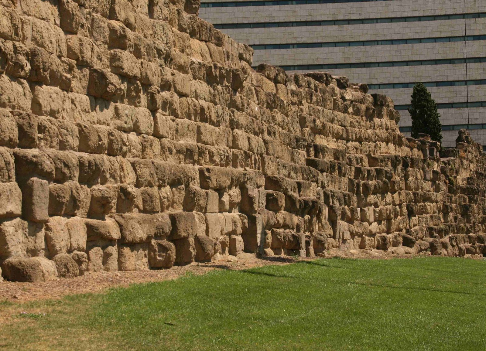
You can see the Servian Walls from the street, for free, with no ticket and no opening hours: the longest section is in front of Termini Station, on the side of Piazza dei Cinquecento, and other fragments emerge on the Aventine, in Largo Magnanapoli, on Via Carlo Alberto and in Piazza Manfredo Fanti. The Rome city tourism portal lists them as open-air archaeological remains that can be visited freely, with the Sovrintendenza Capitolina as the reference and the number 060608 for information.
They are the defensive circuit of republican Rome, almost 11 kilometers long, built with large blocks of yellow tuff quarried at Grotta Oscura, in the territory of Veii. Tradition attributes them to the sixth king, Servius Tullius, from whom they take their name. Almost everything you see today, however, belongs to the reconstruction of the fourth century BC, done after the Gauls had taken and sacked the city in 390 BC.
Data checked on September 29, 2026 on the Sovrintendenza Capitolina pages dedicated to the walls and to the Auditorium of Maecenas, on the Rome city tourism portal and on the other sources cited in the text. Since these are open-air remains, the real variable is not hours but roadworks, fencing and closed areas: anyone who wants a specific section does well to check the Sovrintendenza's website first or call 060608.
At a glance: address, hours, ticket
- Where: scattered sections in the center. The main one in Piazza dei Cinquecento, in front of Termini Station. The Roma Capitale portal gives Via Giosuè Carducci 1 as the reference address.
- Operator: Sovrintendenza Capitolina ai Beni Culturali, as listed by the Rome city tourism portal. Some sections fall inside public or private buildings.
- How to get in: you don't. The main sections are outdoors and are viewed from the sidewalk or from public gardens.
- Price: free. No ticket for the open-air remains.
- Hours: no hours for the street sections. The hours of the gardens that host some of them are not published on the Sovrintendenza page dedicated to the walls.
- Getting there: Metro line B to Termini, Cavour and Circo Massimo, then on foot.
- Information: Roma Capitale contact center 060608.
Where it is and what you actually see
The walls are not a single monument. They are a line that ran for about 11 kilometers and enclosed, according to the Sovrintendenza Capitolina, 426 hectares: the largest circuit among those of the same period preserved in Italy. Today pieces of that line remain. Some tens of meters long, others reduced to a few blocks in a flower bed, still others inside courtyards, basements and cellars. To understand them you have to put the pieces in order.
The table gathers the sections the sources list as visible, with the way you view them. The location data come from the Sovrintendenza Capitolina page, the Rome city tourism portal, the page of the parish of Santa Maria Maggiore in San Vito, the survey of sites by Sotterranei di Roma and, for measurements, the encyclopedia entry on the walls. Where a source doesn't say if the section is accessible, the table notes it.
| Section | Where | How you see it |
|---|---|---|
| Piazza dei Cinquecento | In front of Termini Station, toward Porta Viminale | From the sidewalk, free. The longest and tallest section |
| Underground hall of Termini | Lower level of the station | Two stretches of the agger, one inside a fast food place in the station |
| Piazza Manfredo Fanti | Garden around the former Acquario Romano | Remains of the agger, from the garden |
| Via Carlo Alberto | Spur next to number 45, toward the Arch of Gallienus | From the street |
| Largo Leopardi | Next to the Auditorium of Maecenas | Two rows of blocks. The monument is closed for works |
| Via Salandra | Seat of the Carabinieri Forestry Units Command | Inside a public building, access not stated |
| Largo Magnanapoli | Central flower bed of the square and Palazzo Antonelli | About 10 meters of wall in the flower bed, free |
| Viale Aventino | Along the avenue, toward Piazza Albania | About 42 meters of wall, from the sidewalk |
| Piazza Albania and Via di Sant'Anselmo | Aventine | Fragments on the street, with the arch for throwing machines |
| Capitoline Hill | Gardens between the Aracoeli and the Vittoriano staircase | Remains near the tomb of Gaius Publicius Bibulus |
The section in Piazza dei Cinquecento is the one almost everyone passes without knowing it. It is on the forecourt in front of the station, in the area of the ancient Porta Viminale. According to the encyclopedia entry on the walls it measures about 94 meters in length, about four in thickness, and preserves 17 courses of blocks for about eight meters in height. It is the best-preserved piece of the whole circuit.
Here the plain offered no natural defenses. The Sovrintendenza explains that from the Porta Collina to the Porta Esquilina the flat ground forced the builders to add an agger, that is, a ditch with a great earthen embankment behind the wall. The section in front of Termini is the outer face of that system. The embankment, over 30 meters wide according to current measurements, is gone today.
On the Aventine the landscape changes. The wall follows the hill, along Viale Aventino and as far as Piazza Albania, among buildings, trees and the traffic coming down toward the Pyramid of Cestius. The page of the parish of Santa Maria Maggiore in San Vito lists a section of about 42 meters along the avenue. On Via di Sant'Anselmo, a little higher up, is the piece with the arch for a throwing machine.
Largo Magnanapoli is the most disorienting case. In the middle of the square, between the cars climbing from Via Nazionale and those going down toward Trajan's Forum, the central flower bed preserves a section of about 10 meters. Here the Porta Sanquale opened. Three courses remain, 12 blocks in all, each of about 120 by 57 by 54 centimeters according to the encyclopedia entry: measurements that give a precise idea of the scale of the work.
On the Esquiline the remains are more fragmented. In Piazza Manfredo Fanti, in the garden around the former Acquario Romano, now Casa dell'Architettura, the Sovrintendenza lists the remains of the agger, the same system of embankment and ditch seen at Termini. It is the starting point chosen by the Sovrintendenza itself for its guided visits to the walls, a sign that it is the best place to understand how the defense worked on the plain.
A little further south, on Via Carlo Alberto, the Sotterranei di Roma survey lists a spur of wall next to number 45. The street leads toward the Arch of Gallienus, on Via di San Vito, which corresponds to the ancient Porta Esquilina. It is one of the few gates of the circuit of which a monumental sign remains, although in the form given to it by later rebuilding. From here the line of the walls turned south, toward the Celio.
In Largo Leopardi, along Via Merulana, the encyclopedia entry lists remains in two courses of blocks. Next to it is the Auditorium of Maecenas, which according to the Sovrintendenza leans against the walls just outside their perimeter. It is one of the few points where you understand what happened to the circuit when it lost its function: the gardens of the great Roman families spread until they touched it, and private buildings used it as a support.
Two more sections complete the picture, but they should be counted with caution. On Via Salandra the encyclopedia entry places a section inside the seat of the Carabinieri Forestry Units Command, therefore in a public building and not in an open garden. On the Capitoline Hill remains survive in the gardens between the church of the Aracoeli and the Vittoriano staircase, in the area of the tomb of Gaius Publicius Bibulus. Here the wall leaned against the rock of the hill.
A curiosity about the Servian Walls
On the tuff blocks you can still see incised marks. The encyclopedia entry on the walls describes them as rather rough incisions of signs and alphabetic characters that look Greek, probably used to check the progress of the work. The most cited hypothesis is that part of the workforce came from Syracuse, the great Greek city of Sicily, where fortifications in squared blocks were an advanced craft.
The idea of a team of Greek stonecutters working in Rome in the fourth century BC shifts quite a lot the image of a closed, rustic city. Rome, then, looked outside for the skills it lacked. The same marks, moreover, served an enormous building site: 11 kilometers of wall about 10 meters high are not built by a single firm, but by many crews dividing up the lots.
To find the marks you need patience. They have to be sought on the faces of the blocks most sheltered from rain, and the raking light of morning or late afternoon helps a lot. On the section in Piazza dei Cinquecento the eye tends to stop on the mass of the wall, and the details escape. In Largo Magnanapoli and on the Aventine, where you get closer to the stone, the search is easier.
Something nobody tells you about the Servian Walls
The name promises a king of the sixth century BC. The stone says otherwise. The yellow tuff of Grotta Oscura, from which almost all the visible circuit is made, came from quarries in the territory of Veii. Rome conquered Veii in 396 BC, and the Roma Capitale portal uses precisely that as a limit: before that date those quarries were not available. The walls you see are almost two centuries younger than Servius Tullius.
This doesn't mean the king built nothing. The Sovrintendenza Capitolina places an older core in the sixth century and recalls that the oldest layout used smaller blocks of gray granular tuff, different from the yellow one. Remains of that phase exist, but they are few and hard to recognize for anyone who isn't an expert. What gets photographed at Termini belongs to the later phase.
The contrarian position, in our opinion, is this: the section in Piazza dei Cinquecento, the one that ends up in every guide, is not the best one to look at. It is long and tall, certainly, but it sits in a sunken area, surrounded by barriers, bus stops and traffic, and the eye reads it as any old wall. The Aventine section, with the arch on Via di Sant'Anselmo, tells much more about how the circuit worked.
Who really built them and when?
Current reconstructions place the start of the fourth-century circuit in 378 BC, with the censors Spurius Servilius Priscus and Quintus Cloelius Siculus, and speak of a building site lasting over 25 years. The Roma Capitale portal places the visible structures in the middle of the century. The two indications hold together: a documented start date, and then decades of work to close a ring of 11 kilometers.
The reason is written in the city's history. In 390 BC the Gauls arrived in Rome, took it and sacked it. The Sovrintendenza ties the reconstruction precisely to that trauma: the existing defenses had proved insufficient. The response was a wall about 10 meters high and four thick, with a ditch in front and, at the weak points of the northeast plain, the great embankment of the agger.
The measurements of the agger, according to the encyclopedia entry, are impressive: an embankment over 30 meters wide and about five high, preceded by a ditch on average more than 30 meters wide and up to nine deep. Between the Quirinal and the Esquiline the city had no hills to lean on, and the defense had to be built from scratch. It is the stretch that today corresponds to the Termini area and Piazza Manfredo Fanti.
The wall was restored several times. The sources record work in 353, 217, 212 and 87 BC, that is, at the moments when Rome felt threatened, from the wars against Hannibal to the civil ones. Then, with the expansion of the State, the walls lost their defensive function. Already in the Augustan age the city had overrun them on every side, and the gates became road passages or monuments.
Even afterward, though, the circuit continued to matter on paper. The encyclopedia entry recalls that the distances of the great roads were calculated starting from the gates of the fourth-century republican circuit. The wall, that is, remained the zero point of Rome's administrative geography even when nobody defended it anymore. Only the Aurelian Walls, built much farther out in the third century AD, replaced it.
How did the defense work?
The principle was simple. Where there were hills with steep sides, a wall on the edge, leaning against the rock, was enough. Where the ground was flat, as between the Quirinal and the Esquiline, the wall alone was not enough. You needed an obstacle in front, the ditch, and a mass behind, the embankment, which made the wall hard to knock down and gave the defenders a wide space to move and fight.
The masonry technique can still be read well. The tuff blocks, up to about 60 centimeters high according to the encyclopedia entry, are laid in alternating rows, one with the blocks set as headers and one with the blocks set as stretchers. The result is a wall that binds in depth, not a simple facade. Anyone who looks closely at the section in Piazza dei Cinquecento sees this alternation from one course to the next.
The defense was not only passive. The Roma Capitale portal recalls that the circuit was equipped with war machines, including catapults. Two preserved arches, one in Palazzo Antonelli in Largo Magnanapoli and one on Via di Sant'Anselmo on the Aventine, are interpreted as platforms for catapults or ballistae, added in later restorations to the first building phase. From those openings defenders fired on attackers from a protected position.
The gates were the weak points, and at the same time the vital ones. The roads to Latium and Italy left from there, and the control of who came in and out was concentrated there. Many took their name from the roads, the cults or the areas they served: the Collina toward the Quirinal, the Viminale toward the Viminal, the Esquilina toward the Esquiline. For other gates the origin of the name is debated, and the sources don't agree.
My advice for visiting the Servian Walls
The advice is not to treat them as a monument to see in 10 minutes, but as a thread to follow on foot. A sensible route starts from Piazza dei Cinquecento, goes through Piazza Manfredo Fanti and Via Carlo Alberto to the Arch of Gallienus, and goes down toward Largo Leopardi. It's all flat or nearly so, on the Esquiline, and takes an hour without hurrying.
The Aventine deserves a separate morning. You climb from Viale Aventino, look at the section along the avenue, then Piazza Albania and Via di Sant'Anselmo. From there the walk continues naturally toward the Basilica of Santa Sabina, the Orange Garden and the keyhole of the Villa del Priorato di Malta. The walls become the first stop of a morning on the hill.
Largo Magnanapoli fits well with a tour of the Forums. It is at the top of Via Quattro Novembre, above the Markets of Trajan, and you reach it climbing from Piazza Venezia in a few minutes. Anyone who already plans Trajan's Column can add a stop in front of the flower bed and then continue toward the Quirinal, along the line of the circuit.
A practical warning: many sections have no panels, or have old, faded ones. It's best to arrive with the map ready, perhaps with the points saved on your phone, because on site nobody will tell you where to look. And it's best to accept the idea that some remains, like the one on Via Salandra or the stretches inside the station, can be seen only in part or not at all.
On the order of stops, it's best to start from Piazza Manfredo Fanti, where the agger is best understood, and then arrive at Piazza dei Cinquecento. Once you have seen the system, the wall in front of Termini stops being a fragment and becomes the outer face of a larger defense. Anyone who does the opposite, starting from the station, risks dismissing the most important section as a mere ruin in the traffic.
Do you pay anything and do you need to book?
For the open-air sections you pay nothing and book nothing. The Rome city tourism portal presents them as remains that can be visited freely, and the main ones are on sidewalks, flower beds and public gardens. There is no Servian Walls ticket and no single paid circuit. Even the two stretches in the station's underground are in areas open to anyone using Termini.
The guided visits are another matter. The Sovrintendenza Capitolina periodically offers free itineraries with mandatory booking: for example the one on April 25, 2025, starting from Piazza Manfredo Fanti in front of the Casa dell'Architettura, lasting 90 minutes, with turns in English and Italian, and stops at the agger of Piazza dei Cinquecento, the agger of Piazza Manfredo Fanti and the Arch of Gallienus. The calendar can be followed on the Sovrintendenza Capitolina website.
Anyone who also wants to enter the Auditorium of Maecenas, which leans against the walls in Largo Leopardi, should know that the Sovrintendenza lists it as closed to the public since August 1, 2024 for works funded by the PNRR. When it was open the visit cost €9.50 full price and €5 reduced, free for Rome residents with ID and for MIC card holders, with booking at 060608.
Another well-known fact, yet rarely cited
Many people know that Termini station is built on top of a piece of ancient Rome. Less often cited is the fact that the wall in front of the facade is not an isolated find, but the visible part of a defense that continues under the station. According to the encyclopedia entry, two stretches of the agger are preserved in the underground area of the station hall, a few meters from people running for a train.
One of the two stretches is inside a fast food place in the station, and it makes you smile if you discover it by chance with a tray in your hand. The meaning, though, is serious. In the works of a big city, ancient remains are rarely moved. They are kept where they are, and the new building adapts. That is why in Rome you can find republican tuff between a sales counter and an escalator.
The number of gates is also less certain than it seems. The Roma Capitale portal speaks of about 12 gates, while the traditional list puts 17 in a row, from the Fontinale near the Capitoline Hill to the Flumentana near the Tiber. The sources don't agree because some gates are known only from ancient texts, and their position is reconstructed. Of many, nothing remains above ground.
Finally there is an aspect guides overlook: the Servian circuit never had a uniform appearance. Sections built at different times, repeated restorations, added arches, rebuilt gates. What you see today at Termini, on the Aventine and in Largo Magnanapoli is not the same wall at the same moment, but three episodes of a history at least three centuries long, from the fourth to the first century BC.
The right photo to take at the Servian Walls
The photo that best tells the story of the walls is not that of the isolated section, but that of the contrast. In Piazza dei Cinquecento it's best to frame the tuff blocks in the foreground with the station facade, or the buses, in the background. Two worlds a few meters apart: the city of the fourth century BC and the one that arrives and departs every day from Rome's biggest railway hub.
The right light, at Termini, is early morning, when the forecourt is still less crowded and the raking sun brings out the joints between the blocks. In the afternoon the wall goes into shade and becomes a gray mass. A good alternative is the evening, with the street lighting: the yellow tuff takes on a warm color you don't see by day.
On the Aventine the photo to take is that of the arch on Via di Sant'Anselmo. An arched opening inside a defensive wall looks like a contradiction, and precisely for that reason it should be photographed well, straight on, with the whole wall on both sides. Anyone with a wide-angle lens should use it here. In Largo Magnanapoli, instead, the shot from above works, with the flower bed and the blocks in the middle of the traffic.
A third possibility, less obvious, is Piazza Manfredo Fanti. Here the remains of the agger sit in the greenery, with the nineteenth-century building of the former Acquario Romano behind. The photo that works puts the two things together: the republican stone below and the Acquario's facade in the background. On sunny days it's worth looking for the shade of the trees to avoid too harsh a contrast on the tuff.
How do you get to the main sections?
For the longest section there's no problem: Metro line B stops at Termini, and from there you come out onto Piazza dei Cinquecento. Even those arriving by train, from the airport or from Lazio stations, have the walls in front of them as soon as they leave the station. Piazza Manfredo Fanti and Via Carlo Alberto can be reached on foot in 10 to 15 minutes, toward Piazza Vittorio.
For the Aventine the most convenient stop on line B is Circo Massimo. You come out, walk along the Circus Maximus and climb toward Viale Aventino and Piazza Albania. If you prefer, you can get off at Piramide and walk up the avenue. Surface bus lines change often because of works, and it's best to check them on the ATAC website before leaving.
For Largo Magnanapoli the metro helps little. The Cavour stop on line B leaves you about 10 minutes of climbing through Rione Monti. Alternatively you start from Piazza Venezia and climb on foot. By car, in every case, forget it: the center is in a limited traffic zone, and parking around Termini is expensive and crowded.
Some important events that took place here in history
The first event is the one that gave rise to them in their present form: the Gallic sack of 390 BC. The city was taken and sacked, and the memory of that humiliation stayed alive for centuries. The Sovrintendenza explicitly ties the reconstruction of the circuit to that event. The wall you see at Termini is, in a certain sense, Rome's answer to that night.
The building site, however, did not close right away. The date of 378 BC marks the start, and the sources record a first restoration already in 353 BC, when the work of the first phase was just finished or still under way. For a city in almost continuous war with its neighbors, the circuit was a permanent building site more than a work finished once and for all.
The second moment falls at the end of the third century BC, during the war against Hannibal. The sources record restorations in 217 and 212 BC, years when the Carthaginian army was moving through Italy and Rome feared being besieged. The city reinforced them twice in a few years, a sign of how close the siege seemed.
The third is the restoration of 87 BC, in the middle of civil war. In those years the political clash became open war between Roman factions, and the walls were again kept up as a real defense. Then, with Augustus, the city spread beyond the wall, and the circuit stopped being a defensive boundary and became a relic inside the city.
The fourth event is modern. In 1909, according to the encyclopedia entry, about 10 meters of a section about 32 meters long between Via Barberini and Largo di Santa Susanna were demolished. A Latin inscription recalls the preserved section with a play on the verb servare: Quae Urbem servaverunt hic moenia servantur, here are kept the walls that kept the city. The rest ended up under the new Rome.
The last chapter is that of the station. The construction and then the reconstruction of Termini dug exactly where the agger ran, and the section in Piazza dei Cinquecento stayed in view in front of the facade. Today it is one of Rome's most seen ancient remains by number of passersby, and one of the least really looked at.
Who passed by the Servian Walls
The first name is that of King Servius Tullius, who according to tradition reigned from 578 to 535 BC and included the Quirinal, Viminal and Esquiline in the city. Tradition also attributes to him the first great organization of citizens by property classes and the first census. The walls bear his name because ancient authors, starting with Livy, attributed to him the first complete circuit of the city.
Then there are the two censors of 378 BC, Spurius Servilius Priscus and Quintus Cloelius Siculus, to whom current reconstructions attribute the start of the new building site. They are names almost nobody remembers, but they are the ones responsible for the wall you see. And there are the stonecutters, perhaps arrived from Greek Sicily, who left their marks on the blocks without leaving their names.
And there are, by contrast, those who never saw the walls. The Gauls who took Rome in 390 BC found a city without the circuit you see today, and it is precisely their incursion that explains why this circuit exists. The Sovrintendenza ties the fourth-century reconstruction to that sack: the earlier defenses had not held, and Rome decided not to run the same risk again.
In the imperial age the walls had already lost their role. In the Largo Leopardi area, in the gardens linked to the name of Maecenas, Augustus's advisor, the hall now called the Auditorium leaned against the circuit, just outside its perimeter. The Sovrintendenza dates the hall's paintings to the early first century AD. A place of leisure and culture built against a war wall.
The emperor Claudius also enters the history of the walls, indirectly. According to the tradition reported in the encyclopedia entry on Servius Tullius, Claudius identified the king with an Etruscan leader named Mastarna, ally of the Vibenna brothers, and the paintings of the François Tomb at Vulci seem to confirm the existence of these figures. The king of the walls, in short, may have had an Etruscan name.
Finally, every day, a great many people who don't know it pass in front of the walls. Travelers leaving Termini, commuters, tourists with suitcases. The section in Piazza dei Cinquecento is probably the ancient monument in Rome in front of which the most people pass, period. Looking at it carefully, even for just five minutes, is a small act of resistance to the station's rush.
Servius Tullius: what is document, tradition and legend?
What the material evidence says is clear. The visible circuit is from the fourth century BC, built in Grotta Oscura tuff after the conquest of Veii in 396 BC and after the Gallic sack of 390. The Sovrintendenza also recognizes an older layout, of the sixth century, in smaller blocks of gray tuff. A fortification of the regal age, then, existed, even if little of it remains.
What tradition says is that it was Servius Tullius who wanted the first complete circuit. Livy, as reported by the encyclopedia entry on the walls, attributes to him the rampart, the ditch and the wall around the city, in the middle of the sixth century. Other ancient versions assign a first start to Tarquinius Priscus and an extension to Servius. The name of the walls comes from this tradition, not from the excavations.
To the same tradition belongs the idea of a city organized in four parts, the so-called Roma quadrifaria, which the encyclopedia entry links to the defensive design attributed to Servius. The king is said to have included the Quirinal, Viminal and Esquiline, given the city a single perimeter and divided the citizens by census. Walls, territory and citizenship, in the ancient account, are born together, as parts of a single reform.
Then there is the legend, which concerns the king more than the wall. Tradition tells that Servius was the son of Ocrisia, a war prisoner from Cornicolum reduced to servitude in the house of King Tarquinius Priscus, and that Queen Tanaquil had sensed his destiny. She is said to have given him her daughter in marriage and, at her husband's death, maneuvered so that he would be the one to ascend the throne.
The legend also tells of his end. The future Tarquin the Proud is said to have killed him with the help of the king's daughter, Tullia, who is said to have driven her chariot over her wounded father's body. It is a story built to explain the fall of the monarchy and the passage to the republic, more than a chronicle. The walls, built almost two centuries later, inherited his name.
The vanished gates: where were they?
Following the gates is the best way to understand the route. The traditional list starts from the Capitoline Hill with the Porta Fontinale, climbs the Quirinal with the Porta Sanquale in Largo Magnanapoli, the Salutare on Via della Dataria and the Quirinale on Via delle Quattro Fontane. Then it reaches the Porta Collina, between Via Goito and Via Venti Settembre, where the hill ended and the plain began.
From here the agger started. The Porta Viminale opened in the area of present-day Piazza dei Cinquecento, the Porta Esquilina on Via di San Vito, where it was later transformed into the Arch of Gallienus, near the church of Sant'Eusebio all'Esquilino and Piazza Vittorio. Further south the Porta Celimontana corresponds to the Arch of Dolabella, and the Querquetulana stood in the area of the Basilica of San Clemente.
The Porta Capena opened near the Circus Maximus, at the start of Via Appia. On the Aventine were the Naevia, the Raudusculana in Piazza Albania and the Lavernale near the church of Sant'Anselmo. At the foot of the hill, the Trigemina. Then the gates near the Tiber: the Trionfale in the Sant'Omobono area, the Carmentale toward the present-day Anagrafe and the Flumentana near the temple of Portunus, at the Forum Boarium.
Anyone who knows the gates of the Aurelian Walls, like Porta San Sebastiano, Porta Maggiore or Porta Pia, has to forget that image. Of the Servian gates almost nothing monumental remains, except the Arch of Gallienus, which is the Porta Esquilina transformed in a later period, and the Arch of Dolabella on the Celio, linked to the Porta Celimontana. The others are names, reconstructed positions and the odd block incorporated into a building.
When can't you see anything and what shouldn't you expect?
The street sections never close. The limit is something else: building sites, scaffolding, fencing. Piazza dei Cinquecento is a hub for buses and taxis, and the area around the wall can be fenced off differently from one visit to the next. Before organizing a walk with a group, it's best to stop by and look or call 060608 to ask if there are restricted areas.
Don't expect panels, marked routes or a visitor center. The Servian Walls are not a museum site, and the Sovrintendenza doesn't publish a permanent itinerary with hours. Anyone looking for a museum on Rome's fortifications will find the Museum of the Walls inside Porta San Sebastiano, but that is dedicated to the Aurelian Walls, another circuit built six centuries later.
Don't expect to see the wall from the inside either. The section on Via Salandra is in the seat of a Carabinieri command, the arch of Palazzo Antonelli is part of a building whose access the sources don't state, and the Auditorium of Maecenas, which would let you see the relationship between the hall and the circuit, is listed as closed since August 1, 2024 for works. What remains is the street, which for these walls is the normal condition.
One last warning concerns the stretches under the Termini hall. They are in a commercial passage area, and they change appearance depending on work in the shops and restaurants. They may turn out to be covered by fittings or hard to spot. If your time is short, better to concentrate on the outer section in Piazza dei Cinquecento and leave the underground to a passing visit.
Eating near Termini and the Aventine
Around Termini the traps are the usual ones, only more concentrated. Picture menus displayed in four languages, touters who stop people coming out of the station with suitcases, kitchens open nonstop from 11:00 in the morning to midnight with no break. These are signs that the place works on passing trade, on people who won't come back. A Roman who has to eat in the area picks a street farther in, away from the forecourt.
Other signs to recognize: the window where a lady rolls out fresh pasta in front of passersby, which is show more than cooking, the chalkboards with dishes without prices, the menu that differs between inside and outside, prices that change depending on who orders. None of these is a crime. Put together, though, they say the place counts on you not knowing the city.
On the Aventine the problem is the opposite: there are few places, and the hill is mostly residential. It's best to go down toward Testaccio, where neighborhood Roman cooking can still be found at honest prices, or bring something and stop in a public garden. To choose without surprises, a starting point is the list of addresses on Google Maps, with places selected across Rome and Lazio.
What to combine in a day
Around Termini the natural pairing is with the Museo Nazionale Romano. Palazzo Massimo alle Terme is on the opposite side of Piazza dei Cinquecento, the Baths of Diocletian a few minutes away, with the Octagonal Hall. Between the republican wall and the imperial baths more than six centuries pass, and the difference in technique, from tuff blocks to brick, is caught at a glance.
A few steps away is Piazza della Repubblica, with the Fountain of the Naiads and the Basilica of Santa Maria degli Angeli e dei Martiri in the halls of the baths. Further up, toward the Porta Collina, the Moses Fountain marks the arrival of the Acqua Felice. It is the northern stretch of the circuit, today entirely vanished under the Umbertine city.
Going down toward the Esquiline you meet the Alchemical Gate of Piazza Vittorio, the Nuovo Mercato Esquilino and, along Via Merulana, Palazzo Merulana, a few meters from Largo Leopardi. For an overview of the rione there is our guide Esquiline Hill: things to see, which lines up churches, markets and ancient remains of an area often crossed in a rush.
On the Aventine the walls pair with the hill's churches. From Piazza Albania in a few minutes you reach the Basilica of San Saba, Santa Balbina all'Aventino, in whose gardens the encyclopedia entry lists other remains of the circuit, and Santa Prisca with its mithraeum. A useful overview of the hill is our page Aventine: things to see.
Going down from the Aventine toward Via Appia you pass the Mithraeum of the Circus Maximus and the Baths of Caracalla. Anyone who prefers the Celio side finds San Gregorio al Celio, also listed among the places with remains of the walls, and a little beyond it Porta San Paolo with the Pyramid. These are all stops on foot, with no transport.
For Largo Magnanapoli the obvious combination is with the Quirinal: Piazza del Quirinale, the Scuderie del Quirinale if an exhibition is open, and San Carlo alle Quattro Fontane. On the other side, going down, you reach the Capitoline Hill, where the Capitoline Museums close the day with the hill from which the list of gates begins.
Frequently asked questions
Do you pay for the Servian Walls?
No. The main sections, starting with the one in Piazza dei Cinquecento in front of Termini Station, can be seen from the street or from public gardens with no ticket and no booking. The Rome city tourism portal lists them as freely visitable, with the Sovrintendenza Capitolina as the reference. You pay only for any nearby monuments, like the Auditorium of Maecenas when it is open, or for private guided tours.
Where can you see the longest section?
In Piazza dei Cinquecento, in front of the facade of Termini Station. According to the encyclopedia entry on the walls the section measures about 94 meters in length and preserves 17 courses of blocks for about eight meters in height. It is also the best-preserved piece of the whole circuit, and it is in the area of the ancient Porta Viminale.
Are the walls really from King Servius Tullius?
Only in very small part. The Sovrintendenza Capitolina attributes to the sixth century BC an older core in gray tuff blocks, but almost everything you see belongs to the fourth-century reconstruction, after the Gallic sack of 390 BC. The yellow tuff used came from the Grotta Oscura quarries, available only after the conquest of Veii in 396.
What is the difference from the Aurelian Walls?
They are two different circuits, separated by about six centuries. The Servian Walls are republican, from the fourth century BC, in tuff blocks, and enclosed about 426 hectares. The Aurelian Walls are from the third century AD, in brick, much larger and still largely standing today, with monumental gates like Porta San Sebastiano or Porta Maggiore. The Servian ones survived only in pieces.
Is it true that a section is inside a fast food place?
Yes. In the underground of the Termini Station hall two stretches of the agger are preserved, and one of the two is inside a fast food outlet on the lower level. It is in a commercial passage area, and fittings and works often change its appearance. The outer section in Piazza dei Cinquecento remains much easier to read.
Are there guided tours of the Servian Walls?
The Sovrintendenza Capitolina periodically organizes free itineraries with mandatory booking, like the one on April 25, 2025 that started from Piazza Manfredo Fanti, lasting 90 minutes, with stops at the agger of Piazza dei Cinquecento, at Piazza Manfredo Fanti and at the Arch of Gallienus. There is no fixed calendar: new dates have to be sought on the Sovrintendenza's website or asked about at 060608.
How much time do you need to see the main sections?
For the section in Piazza dei Cinquecento alone, 10 minutes is enough. The Esquiline loop, from Termini to Piazza Manfredo Fanti, Via Carlo Alberto and Largo Leopardi, takes about an hour on foot. The Aventine, with Viale Aventino, Piazza Albania and Via di Sant'Anselmo, is another hour. Largo Magnanapoli adds to a tour of the Forums. In one day you see everything, without rushing.
What is the most interesting section on the Aventine?
The one on Via di Sant'Anselmo, which the encyclopedia entry lists among the best preserved of the circuit, with an arch interpreted as a platform for catapults or ballistae. Along Viale Aventino, toward Piazza Albania, the page of the parish of Santa Maria Maggiore in San Vito lists a section of about 42 meters. Other remains are indicated in the gardens of Santa Balbina and near San Gregorio al Celio.
Can you see them with children?
Yes, and they work better than you'd think, because they are outdoors, free, and lend themselves to a treasure hunt: finding the marks incised on the blocks, counting the courses, imagining where the ditch was. For more ideas on the city with the little ones there is our guide Rome with Kids. Watch out for traffic in Largo Magnanapoli and in Piazza dei Cinquecento.
Who wrote this and from which sources
The text comes from the editorial team of Tour Leader Pro, the Rome-based outfit that designs itineraries, visits and cultural events across Rome and Lazio. Rates, hours and booking arrangements given here come from the official sources cited in the text on the date given at the start: the Sovrintendenza Capitolina pages on the walls and on the Auditorium of Maecenas and the Rome city tourism portal. Let us know what you find changed.
Organizing a walk along the Servian Walls, for yourself or for a group, mostly means building a route among scattered sections, checking for building sites and choosing the order of stops according to light and traffic. For those who organize group trips to Rome, with themed itineraries on the ancient city and its defenses, a useful resource is Tour Leader Pro.
The republican walls are only the first ring of a story that in Rome continues with the Aurelian Walls, the monumental gates, the Renaissance bastions and the nineteenth-century fortifications. Anyone who wants to widen their view to Lazio will find Etruscan and Latin walls in many villages an hour from the capital, from Palestrina to the Castelli. To put together a multi-day trip, a useful resource for putting together an itinerary is Italy Planner.