Porta Maggiore
In short. Porta Maggiore is the point in Rome where two imperial aqueducts, the Aqua Claudia and the Anio Novus, cross together over two consular roads, Via Prenestina and Via Labicana, on a double travertine arch inaugurated in AD 52 under the emperor Claudius.
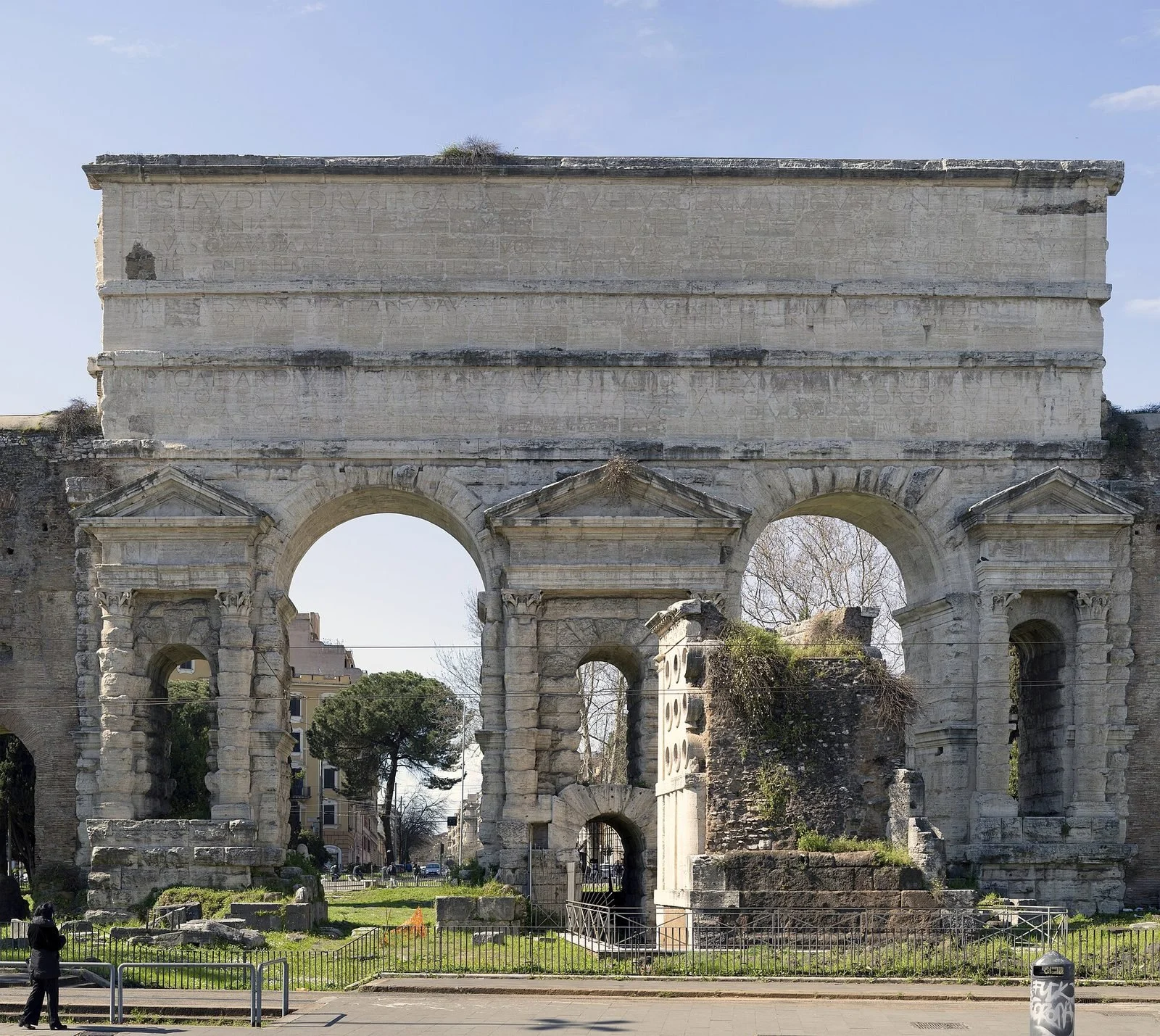
Porta Maggiore is the point in Rome where two imperial aqueducts, the Aqua Claudia and the Anio Novus, cross together over two consular roads, Via Prenestina and Via Labicana, on a double travertine arch inaugurated in AD 52 under the emperor Claudius. It wasn't born as a city gate. It became one more than two centuries later, when Aurelian incorporated the structure into the Aurelian Walls and found himself with a monumental opening already built, for free. Backed against its outer side is the Tomb of Eurysaces the baker, a late Republican tomb that chance saved. It ended up walled inside a late antique defensive tower and emerged from it intact in 1838, when Gregory XVI had the bastion demolished. A few meters away, below street level, runs the Underground Basilica of Porta Maggiore, discovered by chance in 1917 during railway works. Above all this passes today one of the busiest tram junctions in the city. The lines that follow explain how the monument really works, what you see and what you don't, how to get there, how much time it takes and why the square around it remains the unresolved problem of this corner of Rome.
Where Porta Maggiore is and how to get there
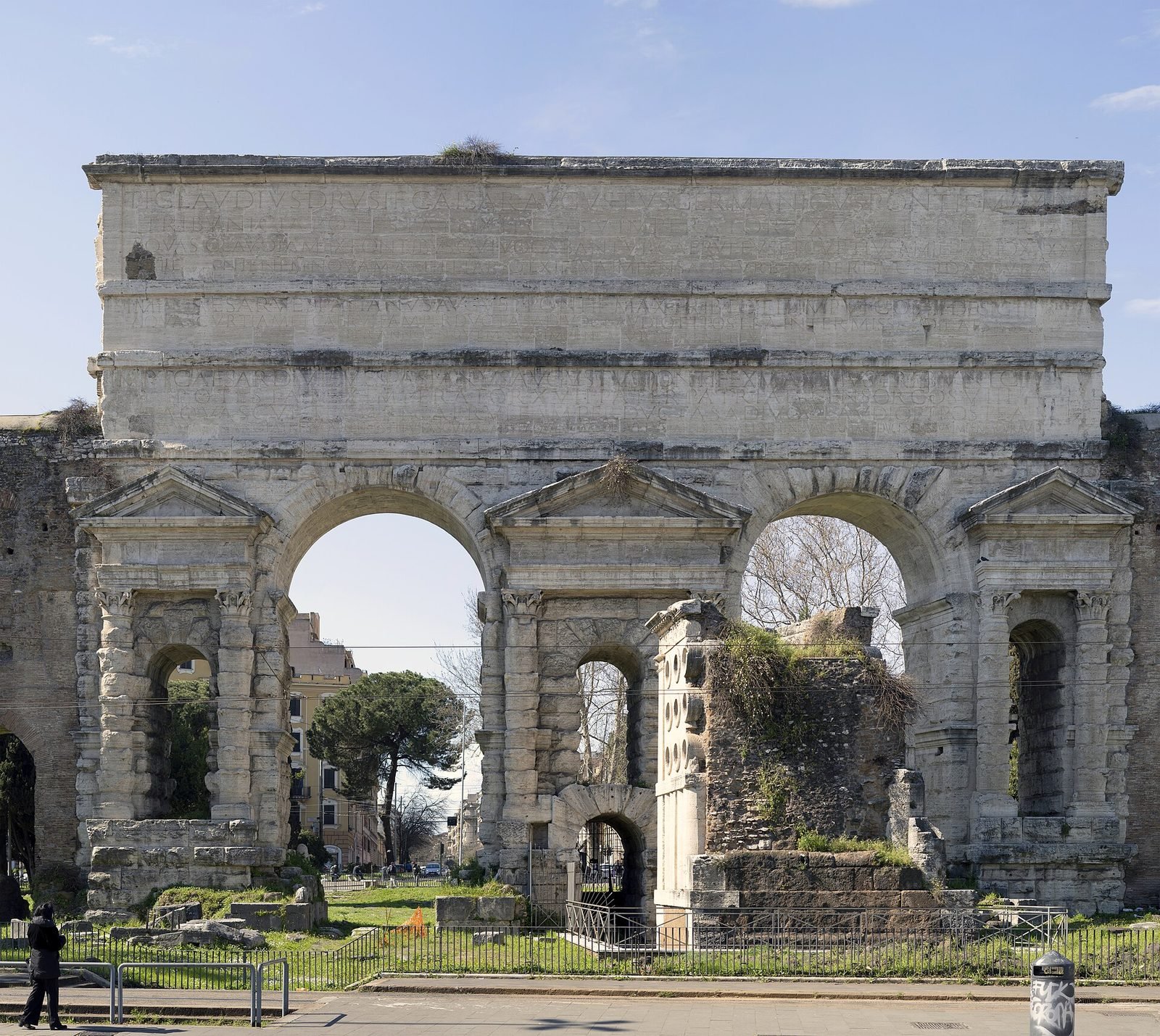
Porta Maggiore is in Piazza di Porta Maggiore, on the border between the Esquilino and Castro Pretorio districts and the Prenestino and Tuscolano neighborhoods, at the exact point where Via Casilina and Via Prenestina still split today as the ancient Via Labicana and Via Prenestina did. Access is free, in the open air, 24 hours a day: there is no ticket office, no gate, no opening hours. The monument is viewed from the street and from the pedestrian islands of the square.
On foot from the center
From Termini you walk for 15 to 20 minutes along Via Giolitti, skirting the south side of the station. It's the simplest route to explain and also the ugliest to do, because Via Giolitti is a railway service road with nothing to look at. Whoever has time does better to pass through Piazza Vittorio, where the Porta Alchemica is and a couple of steps away is the Nuovo Mercato Esquilino, and then go down toward Porta Maggiore along Via di Porta Maggiore. About the same time, many more things to see. From Santa Maria Maggiore it's a scant 20 minutes, and the same walk was made by the pilgrims from whom the gate took its current name.
By tram
The tram is the right way. The square is served by tram lines 5, 14 and 19, which pass through it or terminate nearby, and the stop is called Porta Maggiore. Lines 5 and 14 connect Termini with the eastern quadrant (Gerani and Palmiro Togliatti), and line 19 arrives from Centocelle and continues toward the north center up to Piazza Risorgimento. Surface lines in Rome often change because of construction sites and detours, even for months: before leaving it's best to check the updated route on the transport company's website or app. To find your way among tickets, time validity and metro and bus integration, we have collected the full picture in the guide on how to get around Rome.
By metro
There is no metro stop at Porta Maggiore. The nearest is Vittorio Emanuele, on line A, from which you walk about 10 minutes going down Via di Porta Maggiore. Manzoni, also on line A, is about 10 to 12 minutes on foot passing under the walls. Whoever comes from line B gets off at Termini and continues by tram or on foot. This is one of the reasons why many tourists never set foot there: there is no stop with the monument's name, and on the metro maps Porta Maggiore simply doesn't appear.
By car and by bicycle
We advise against the car. The square is an intersection with traffic lights and tram tracks on several axes, bus lanes and heavy traffic on Via Casilina and Via Prenestina, and the regular parking spots around are very few. By bicycle you can cross the area, but the tram tracks should be taken as perpendicular as possible: the rails curving in the middle of the square are the most common cause of falls at that spot.
What Porta Maggiore is: an aqueduct lent to the walls
Porta Maggiore is, in substance, a piece of hydraulic plant built in AD 52 to carry two aqueducts over two roads without interrupting them. Everything else, the function of city gate, the name, the role as a junction, came later, and more than once against the original design.
The double arch and the pair of roads
The structure has two large side-by-side arches, separated by a central pier. Under the left arch, looking from outside the city, passed Via Prenestina, which led to Praeneste, today's Palestrina. Under the right one passed Via Labicana, heading toward Labicum and later merged into the route of the modern Via Casilina. The two roads diverged exactly there, and still diverge: it is one of the rare cases in which today's road layout follows an ancient fork point by point. Excavations and works have brought to light under the arches the Roman road surface, paved with flint basalt blocks, which runs several meters lower than the current asphalt. That difference in level is the most instructive thing about the monument: it measures at a glance how much Rome has risen in 20 centuries.
The two channels in the attic
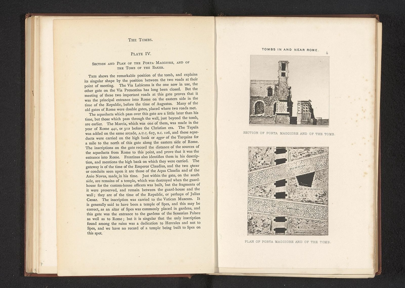
Above the arches, in the upper body of the construction, run two superimposed conduits. The lower one carried the water of the Aqua Claudia, the upper one the water of the Anio Novus. This isn't a textbook detail: you can see it with the naked eye, in section, looking at the side of the structure where the attic is cut. Two dark rectangles, one above the other, inside the wall. Whoever doesn't know what they're looking for mistakes them for walled-up windows. They are the two specus, the channels in which the water flowed, lined inside with cocciopesto for waterproofing.
The travertine left rough
The most striking visual feature is that much of the travertine is not finished. The blocks of the piers are left in rustic ashlar, with the outer face roughly hewn and irregular, while the columns, the pediments and the cornices of the aedicules framing the arches are worked with precision. The contrast is deliberate. For a long time people thought of an interrupted building site, or a rush to deliver. Today the prevailing reading is that it was a choice of taste of the age of Claudius, an aesthetic of the rough applied deliberately to public works. The same treatment is found in the substructures of the temple of the Divine Claudius on the Caelian, those still seen when climbing toward the Basilica of Santi Giovanni e Paolo, and in other Claudian works of the same season. It is a way of building that declares the strength of the work instead of hiding it under a smooth slab.
The three inscriptions of the attic: Claudius, Vespasian, Titus
On the attic of Porta Maggiore, on the side facing the outside of the city, three superimposed Latin inscriptions can be read, carved at different times between AD 52 and 81. They are the part of the monument that best withstands comparison with any guidebook: the text is still there, legible, and tells the whole technical story of the work.
The inscription of Claudius, AD 52
The first and largest is the dedication of Tiberius Claudius Caesar Augustus Germanicus. It declares that the emperor had the Aqua Claudia brought into the city at his own expense, drawn from the springs called Caeruleus and Curtius at the 45th mile, and the Anio Novus, taken at the 62nd mile. These are two precise technical pieces of information, not rhetoric: they indicate the distance of the intakes along the Aniene Valley. A detail that almost everyone misses is the spelling: in the text the emperor's name appears as CAISAR instead of CAESAR, following an archaizing preference that Claudius, a scholar of antiquities and a reformer of the alphabet, cultivated personally. The epigraph is at once an administrative act and a scholar's whim.
The inscription of Vespasian, AD 71
Below, a second epigraph records the restoration carried out by Vespasian. The text says that the aqueduct had remained interrupted and in ruins for nine years and that the emperor restored it to the city at his own expense. Nine years of a dead conduit mean nine years in which the high districts of Rome, which that water alone could reach by altitude, were dry. An aqueduct requires permanent maintenance, and when maintenance lapses the city notices within a few days. Vespasian's epigraph documents it better than any treatise.
The inscription of Titus, AD 81
The third inscription, lower still, is by Titus and records a further intervention, 10 years after his father's, with the rebuilding of the conduit starting from the area of the springs. Three epigraphs in 29 years, for a new work, say a great deal about the fragility of a system dozens of kilometers long exposed to landslides, seepage and limescale encrustation. The exact division of contents between the text of Vespasian and that of Titus is a matter for epigraphists, and the editions debate individual restorations. What matters to the visitor is that the monument carries its own maintenance logbook written on it.
Aqua Claudia and Anio Novus: where the water came from
The two aqueducts that pass over Porta Maggiore were begun under Caligula and completed by Claudius in AD 52, and both took their water in the upper Aniene Valley, in the area between Subiaco and Arsoli. They were the two longest and highest systems of the Roman network, and this made them also the most delicate.
The springs and the kilometers
Frontinus, curator of the waters under Nerva and author in AD 97 of the treatise on the city's aqueducts, records for the Aqua Claudia a course of about 46,000 paces and for the Anio Novus about 58,000, that is roughly 69 and 87 kilometers. Modern figures vary slightly depending on how the ancient measures are converted and which route is reconstructed. Whoever finds different numbers in other sources isn't reading a mistake, they're reading a different conversion. The substantial difference between the two systems concerned quality: the Aqua Claudia took clear spring water, while the Anio Novus drew directly from the Aniene River and carried muddy water after every rain, so much so that a piscina limaria, that is a settling tank, had to be built to let it deposit before sending it into the city.
The last stretch above the arches
For the last kilometers the two conduits traveled superimposed on the same arcade, the one still seen today running for kilometers in the countryside southeast of the city and crossed on foot at the Aqueducts Park. Whoever wants to understand Porta Maggiore should go there: there you see the aqueduct as a work of landscape, here you see its urban terminal. They are the same structure two kilometers apart, and seeing them on the same day clarifies the scale of the problem the Romans had solved.
The knot of the waters
In the area of Porta Maggiore converged most of Rome's ancient aqueducts, eight according to the count most common among scholars, arriving from the east following the most convenient ridge. Just inside the gate the Aqua Claudia fed a castellum, that is a distribution tower, and from there started the branch called the Neronian arches, which carried water to the Caelian and from there to the Palatine. Those arches can still be seen, in broken stretches, along Via Statilia and inside the garden of Villa Celimontana. An aqueduct of a different age, the Aqua Virgo, served an entirely different sector of the city instead, and we told its story in the page on Aqua Virgo.
How Porta Maggiore became a gate of the Aurelian Walls
Between AD 271 and 275 the emperor Aurelian had Rome's new circuit of walls built in haste, and to save time and money the project incorporated everything that already existed on the route: tombs, private buildings, stretches of aqueduct and, precisely, the double arch of Claudius, which thus became the Porta Praenestina.
Reuse as a building method
Reuse wasn't an exception but the rule. Along the route of the Aurelian Walls the Amphitheatrum Castrense and part of the imperial Sessorium complex, near Holy Cross in Jerusalem, were absorbed in the same way, as were the Pyramid of Cestius at the other end of the city, which we described in the page on the Pyramid of Cestius, and the castra Praetoria to the north. Porta Maggiore was the most convenient case of all: an opening already tall, already monumental, already stable, that only needed to be closed with leaves and garrisoned. To understand how a gate of the circuit worked when complete with towers, walkway and maneuvering rooms, it's worth making a detour to Porta San Sebastiano, where the Museum of the Walls is housed and you walk a stretch of corridor inside the masonry.
Honorius and the fifth-century tower
At the beginning of the fifth century, between 401 and 403, under Honorius the walls were raised and the gates turned into small fortresses. At Porta Maggiore the intervention was drastic: in front of the Claudian arches a massive tower was built, with a courtyard closed between two barriers, which turned the passage into a trap for anyone trying to force it. It was a military response to a concrete threat, and it wasn't enough: in 410 the Goths of Alaric entered the city anyway, though through another gate.
The Tomb of Eurysaces the baker
Backed against the outer side of Porta Maggiore, in the wedge of land between Via Casilina and Via Prenestina, is the Tomb of Marcus Vergilius Eurysaces, baker and contractor, built in the second half of the 1st century BC and therefore older by almost a century than the gate that grew up next to it. It is visible free of charge and at any time from the pedestrian island of the square, fenced but completely in view on all sides.
Who Eurysaces was
The name gives him away: Eurysaces is a Greek cognomen, and whoever bore it in Rome in those years was almost always a freedman, that is a freed slave, or a direct descendant of freedmen. The nomen Vergilius indicates the family that had freed him. The inscription describes him as pistor, baker, and redemptor, that is a businessman who takes on contracts: he didn't run a neighborhood oven, he supplied bread on commission, plausibly for public or military supplies. The last word of the formula, APPARET, has been debated for two centuries: the most followed reading links it to the function of apparitor, an attendant in the service of a magistrate, but there is no unanimous agreement and some editions interpret it differently. We point it out because it is one of the few points where an honest guide must say that it isn't known.
The shape of the monument and the cylinders
The tomb has a trapezoidal plan, imposed by the space between the two roads, and an elevation in travertine and faced concrete. Above a solid base runs a double order of cylindrical openings, three rows of circles piercing the wall, which are the most debated element of minor Roman architecture. The two most solid explanations are that they reproduce the mouth of the modii, the capacity measures for grain, or the opening of the kneading troughs or mixers used in bakeries. Neither is proven. What is certain is the intention: the monument declares the trade of the person who paid for it, with an insistence that in the eyes of the Roman aristocracy of the time must have seemed vulgar and that today is the reason this tomb is in all the social history textbooks.
The bread frieze
Under the cornice runs a relief frieze showing, scene after scene, the whole cycle of bread-making: the delivery of grain, the milling with mills driven by animals, the sifting, the kneading, the shaping of the loaves, the baking, the weighing and the delivery. It is one of the most complete figured testimonies that exist of an ancient production process, and it is worth more than 10 pages of treatise. It reads well with binoculars or a modest telephoto lens. With the naked eye, from the fence, you can make out the figures but lose the gestures.
Atistia and the basket-shaped urn
From the tomb also comes the relief with the portraits of Eurysaces and his wife Atistia, now kept in the Museo Nazionale Romano and visible at Palazzo Massimo alle Terme. The inscription relating to the woman says that her remains are in this panarium, that is in this bread basket: the urn had the shape of a baker's basket. The consistency is total, from the facade to the last object. Whoever visits the gate and wants to close the subject should also plan a stop at Palazzo Massimo, about 20 minutes on foot toward Termini.
How the tower saved it
When Honorius had the bastion built in front of the gate, the tomb ended up incorporated into the defensive masonry. For 14 centuries nobody saw it: it was inside the wall, filled in and hidden. This spared it the fate of almost all Roman funerary monuments outside the gates, dismantled block by block and reused as a quarry of material. The tomb has come down to us because it had become part of a fortification, and so it wasn't worth touching.
The rediscovery of 1838
In 1838 Gregory XVI had the Honorian tower demolished, as part of the 19th-century campaign to free ancient monuments from later overlays. Under the rubble the tomb reappeared, intact in its main part. It is the same type of operation that in those years was redrawing the image of ancient Rome almost everywhere, with gains and losses. Here the gain was clear. Elsewhere, medieval layers were demolished that nobody today would let disappear. The choice to sacrifice a late antique fortification to bring to light a late Republican tomb is, by today's criteria, debatable. By the criteria of 1838 it was obvious.
A curiosity about Porta Maggiore
The most solid curiosity about Porta Maggiore is that the most studied monument of the complex doesn't belong to an emperor but to a baker, and that it survived precisely because someone had walled it inside a defensive wall. Within a radius of 20 meters there are the dedication of Claudius, that of Vespasian, that of Titus and the tomb of a freedman who made bread: three emperors and a baker, and the baker is the one whose daily life we know the most about.
The paradox of preservation
It holds as a general principle for all of Rome. The monuments that survive are almost never the most important, they are the ones that at some point became useful to someone else: a church inside a temple, a fortress inside a theater, a palace on top of a stadium. The case of the Basilica of San Clemente and that of the Colosseum tell the same dynamic with opposite outcomes. At Porta Maggiore the rule is seen in pure form: the tomb of Eurysaces still exists because it was used as stone for a bastion.
One thing nobody tells you about Porta Maggiore
Almost no guide writes it: under the two arches the Roman road surface is exposed and visible, several meters below the level of Via Casilina and Via Prenestina, with the flint basalt blocks still in place and the grooves left by carts. You look at it from above, leaning over the parapet, and it is the thing that more than any other makes you understand the history of the spot where you are standing.
The difference in level and what it means
That gap between the ancient level and the modern one isn't an archaeological dig in the common sense of the term: it is the real ground level on which people walked in the 1st century. Everything else, the meters above, is debris, collapses, rebuilding, fill and asphalt accumulated over 20 centuries. Whoever gets used to looking for this difference in level finds it everywhere in the city, from the Roman Forum to the superimposed underground levels that we mapped in the guide on underground Rome.
The Underground Basilica of Porta Maggiore
A few meters from the gate, under the street level of Via Prenestina, is the Underground Basilica of Porta Maggiore, an underground space of the 1st century AD with three naves and stucco decoration, discovered by chance in 1917 during works on the railway line. Access is possible only with organized visits, in limited numbers and with a variable calendar. Conditions change over time and must be verified directly with the Soprintendenza Speciale di Roma, which manages the site. We don't publish hours or fares, because any data of this kind reported here would be out of date within a few weeks.
The discovery of 1917
The monument re-emerged in April 1917 when a subsidence of the ground opened a gap during railway works along the line toward the south. It had remained sealed for 18 centuries. The discovery took place in the middle of the war, which partly explains why the initial investigation was conducted in difficult conditions and with limited means.
What it is, and what is debated about it
The space was created by digging the galleries into the tufa bank and pouring concrete into them, a technique that made it possible to build without opening a building site on the surface. The stucco decoration of the ceilings and walls presents mythological and allegorical scenes that most scholars read as a program of Neopythagorean inspiration, centered on the fate of the soul after death. The interpretation goes back to the first studies of the last century, among them the monograph by Giuseppe Bendinelli and the famous volume by Jérôme Carcopino dedicated to the Pythagorean basilica. Other scholars have proposed different readings, from the meeting hall of a private association to a monumental family tomb. The chronological placement around the age of Claudius and Nero is instead widely shared. Whoever wants the full story of the basilica, with the history of the excavations and the detail of the stuccoes, will find it on our page dedicated to the Underground Basilica of Porta Maggiore. This page deals with the gate and its urban context, that one deals with the hypogeum and its decorative apparatus.
Why it is so hard to get in
The space is small, damp and fragile, and the presence of people alters the microclimatic conditions that hold the stuccoes together. Hence the very small groups, the rare openings and the suspensions for maintenance. Whoever cares must put their name on a list well in advance and accept the idea of not managing it on the first try. It is one of the few Roman cases in which scarcity isn't a commercial choice but a conservation constraint.
The advice I give you for visiting Porta Maggiore
The operational advice is just one: don't come to Porta Maggiore as a destination in itself, but fit it into a route that starts at Santa Croce in Gerusalemme and ends at Piazza Vittorio, and allow 20 or 25 minutes for the gate and the tomb. The visit itself is short, because it's all outdoors and there's nothing to go into. The value comes from the connection with what is around it.
The itinerary we recommend
You get off at the Santa Croce in Gerusalemme stop, see the basilica and the side of the walls with the Amphitheatrum Castrense incorporated, skirt the area of the Circus Varianus, arrive at Porta Maggiore in 10 minutes of walking along the route of the walls, and from there continue along Via di Porta Maggiore to Piazza Vittorio. Whoever still has time continues to Santa Maria Maggiore or takes the tram east to the Mausoleum of Sant'Elena. It's a half-day itinerary, all free except the optional admissions, and it crosses a Rome that passing tourism never sees.
The right time
Early morning is the best time, for two concrete reasons: the traffic in the square is lighter and the light reaches the outer facade, the one with the three inscriptions, which faces east. In the afternoon that front goes into shadow and only the inner side remains legible. On early Sunday morning the square is almost empty and you can cross it calmly, which at this spot is no small thing.
What not to do
Don't cross outside the crosswalks: trams arrive silently around the curve, and visibility is terrible because of the pylons. Don't count on public restrooms or an information point: there aren't any. Don't come expecting an archaeological area equipped with panels and routes, because the layout is minimal and the signage scarce. If you need a logistical base with services, the nearest reference is the Termini area, and to find your way among the zones of Rome we wrote the guide on where to stay in Rome.
Another well-known fact, yet rarely cited
The fact is this: the Aqua Claudia did not serve the whole city, it served mainly the high districts, because it arrived at an altitude sufficient to reach them by gravity. Roman aqueducts worked without pumps, and the only variable that counted was the height of the arrival point. This is why the Anio Novus runs above the Aqua Claudia in the same wall: it was the highest conduit in the network, and this allowed it to serve the areas that no other system reached.
Altitude rules everything
All ancient hydraulics comes down to a constant, minimal gradient maintained for dozens of kilometers. An error in altitude of a few centimeters per kilometer made the work useless. Roman surveyors worked with the groma and the chorobates, a water level as long as a bench, and the result seen at Porta Maggiore is the end point of that precision. The upper conduit served the Caelian, the Aventine and the Palatine. The low areas already had water from older systems.
Why the gate is where it is
The reason is topographic before it is urban. The saddle between the Esquiline and the Caelian was the natural passage for bringing water into the city while keeping altitude, and the two roads passed there for the same reason. 200 years later, when the walls were laid out, the wall ran where the aqueduct ran because it was already a continuous, high line. Today's tram traffic follows the same corridor. Four eras, one geography.
The right photo to take at Porta Maggiore
The photo that works is just one and it isn't the one of the gate: it's the Tomb of Eurysaces shot from the pedestrian island between Via Casilina and Via Prenestina, with the double travertine arch rising behind it and the three inscriptions legible at the top. In a single frame fit a Republican tomb, an imperial aqueduct, a late antique gate and, if you wait for the moment, a tram. Four eras superimposed with no need for a caption.
Where to shoot from
The spot is the traffic island in front of the tomb, on the outer side of the gate. You reach it with two crossings at traffic lights. With a moderate wide-angle lens you keep the whole group. With a telephoto you isolate the bread-making frieze, which is lost to the naked eye. A tripod at that spot is awkward and not very safe for pedestrian passage: better to work handheld, raising the sensitivity.
The light
The front with the epigraphs faces the outside of the city, to the east, so it takes direct light in the first hours of the day. That is when the carved letters have the relief of shadow that makes them legible in a photograph. In the late afternoon the same facade is flat, while the inner side toward the city lights up. Overcast sky, which is usually considered a problem, helps here the frieze of the tomb, because it eliminates the harsh contrasts between the figures and the background.
What to avoid
Avoid the tight frontal framing of the gate alone: without a term of comparison, the double arch in a photograph looks low and loses all its scale. Also avoid including the tram line poles in the middle of the arches, because they cut the image vertically. If you move a few meters toward the tomb they disappear from the field. Photographing here is allowed without restrictions, since it is an open-air monument on public ground. The rules change for the hypogeum, where filming is subject to the conditions set by the Soprintendenza.
Some important events that happened here in history
The chronology of Porta Maggiore covers 20 centuries and can all be read on the stone: AD 52 the construction, 71 and 81 the imperial restorations, 271 the incorporation into the walls, 403 the fortification by Honorius, 537 the cutting of the aqueducts, 1838 the demolition of the tower, 1917 the discovery of the hypogeum.
AD 52: the inauguration
Claudius completes two aqueducts begun under Caligula and delivers them to the city in the same year. It is the most important hydraulic work since the time of Agrippa, and the double arch over the two roads is its calling card.
71 and 81: the two Flavian restorations
Vespasian puts the conduit back into operation after nine years of interruption, and Titus intervenes again a decade later starting from the springs. The two epigraphs remain on the attic under that of Claudius, in descending chronological order.
271: the gate enters the walls
With the construction of Aurelian's circuit the arch becomes Porta Praenestina and takes on a military and customs function that it will keep for over 1,600 years.
403: the tower of Honorius
The Honorian restructuring turns the gate into a small fortress with an inner courtyard, and on that occasion the tomb of Eurysaces is incorporated into the defensive masonry.
537: the aqueducts cut
During the siege of the Gothic War the conduits that fed the city are interrupted. The empty channels above Porta Maggiore become potentially passable galleries, and for this reason they are barred from the inside.
1838: Gregory XVI has the bastion demolished
The demolition of the tower brings to light the Tomb of Eurysaces, which had remained hidden inside the masonry since the fifth century. It is the date that changes the perception of the monument, which from fortified gate goes back to being a visible aqueduct.
1917: the discovery of the underground basilica
A subsidence of the ground during railway works opens access to the Neopythagorean hypogeum, sealed since the 1st century. The news circulates little, because the country is at war, and systematic study arrives in the 1920s.
July 19, 1943: the bombs on the neighboring district
The bombing of San Lorenzo hits the quadrant immediately to the north, between the rail yard and the Verano Cemetery, devastating the basilica of San Lorenzo fuori le mura. Porta Maggiore suffers no direct damage, but the episode permanently marks the memory of the whole area east of the station.
Who has passed through Porta Maggiore
Through Porta Maggiore has passed, in 20 centuries, anyone arriving in Rome from the east: from the travelers of Via Prenestina to the medieval pilgrims headed for the basilicas, to the commuters who today get off the tram. The names that follow are the documented ones, not the legendary ones.
Claudius, Vespasian, Titus
The three emperors who signed the attic did not pass by there in a manner of speaking: the dedication of a public work involved a ceremony, and the inauguration of AD 52 was a court event. Claudius in particular cared about hydraulic works, and it was he who had the Lake of Nemi partly drained and the outlet of the Fucine designed.
Marcus Vergilius Eurysaces and Atistia
A baker and his wife, buried at that spot a century before the gate existed, are the two people whose biography we know best in this place. Of the second we know almost nothing beyond the name and the shape of the urn, and precisely for this their monument is a richer source than many senatorial inscriptions.
Pilgrims and the roads of the basilicas
Throughout the Middle Ages and the modern age, whoever arrived from the east to visit the basilicas entered here and took the road that led to Santa Maria Maggiore, or turned right toward St. John Lateran and the Holy Stairs. Jubilee years multiplied that flow, and the name of the gate is the linguistic residue of this habit.
Piranesi and the view painters
Giovanni Battista Piranesi engraved several times, in the 18th century, the area of Porta Maggiore and the funerary monuments outside the gate, and his plates remain a figured source on the state of the places before the 19th-century works. The views must be read with caution, because Piranesi exaggerated proportions to obtain the effect he wanted, but to understand what was there and what wasn't they are first-hand documents.
Pasolini, Rossellini and the cinema of Prenestino
Porta Maggiore is the threshold of the neighborhoods that postwar Italian cinema made famous. Roberto Rossellini's filming for Roma città aperta took place partly in Pigneto, a few hundred meters beyond the gate, and in the same alleys Pier Paolo Pasolini shot his first film, setting a substantial part of his work in the borgate of the Prenestina and the Casilina. Anyone arriving here as a tourist finds themselves on the border between the Rome of monuments and the Rome of the historic peripheries, and the border is literally a third-century wall.
The Porta Maggiore tram hub
Piazza di Porta Maggiore is one of Rome's main tram hubs, with several lines that cross, diverge and switch right inside the archaeological perimeter. It is a coexistence that has lasted for over a century and that no arrangement has yet resolved satisfactorily.
The lines and how they work
Lines 5, 14 and 19 pass through the square, connecting the eastern quadrant with Termini and with the north center. There are many switches and curves, which explains the continuous metallic noise and the reduced speed of the trains on that stretch. Rome's tram service is subject to scheduled suspensions for track renewal, with bus replacements that can last months: before counting on the tram, it is worth checking the transport company's notices on the same day.
The railway to Centocelle
Alongside the tram lines runs the urban railway Termini Laziali Centocelle, a remnant of the old line to Fiuggi and Frosinone, discontinued in stages in the 20th century. It has narrow-gauge tracks, short cars and a stop at Porta Maggiore. Its fate has been the subject of alternative projects for years, from conversion into a tramway to closure: as things stand there is no definitive decision, and anyone who writes otherwise is getting ahead of events.
Decay and redevelopment: how things really stand
It has to be said clearly, because anyone who arrives without knowing is disappointed: Piazza di Porta Maggiore remains a big urban intersection with a Roman monument inside it, and it has very little of a cared-for archaeological area. Heavy traffic, tracks, intermittent construction sites, flower beds in variable condition, scarce signage and green maintenance that comes in waves.
What you see today
The monument itself is in decent condition and the tomb of Eurysaces is fenced and protected. The surroundings are another story: the lawn areas around the fences often look neglected, the night lighting is patchy and in some periods the square collects trash and makeshift camps. It is the typical situation of Roman spaces straddling the border between the historic center and the neighborhoods, where responsibility is divided among several bodies and nobody is in charge.
The redevelopment projects
Projects to tidy the square, reduce private traffic, reorganize the tracks and enhance the archaeological complex have followed one another for decades and are proposed again at every change of administration. Some targeted interventions have been made, in particular on the tram track and on the appearance of the fences, but the overall layout of the square has not changed substantially. Anyone who reads about an announced project would do well to check its status: between announcement and construction site, here, a lot of time usually passes.
Our verdict
Porta Maggiore is the Roman monument least enhanced relative to its importance inside the walls. It holds up against the Arch of Constantine for quality of masonry and documentary value, and surpasses it for the completeness of the historical account it allows, because it holds together hydraulics, road network, defense and society. It receives a minimal fraction of the visitors. The reason is not the monument, it is the context: nobody likes to stop in the middle of an intersection. Enhancing this spot would mean, first of all, giving back a space where a person can stand still for five minutes in safety.
What to see around Porta Maggiore
Within a 20-minute walk of Porta Maggiore are concentrated the Sessorian complex of Santa Croce in Gerusalemme, the area of the Circo Variano, the Esquilino with the Esquiline Obelisk and the Auditorium of Maecenas, and farther north the San Lorenzo rail yard. Taking the tram east, you reach in 15 minutes the Mausoleum of Saint Helena in Torpignattara, with the catacombs of Santi Marcellino e Pietro.
Toward the center
From here you can reach the Baths of Diocletian, the Basilica of Santa Prassede and, about 20 minutes to the southwest, the Ludus Magnus and the Domus Aurea, on foot or with one change. If you prefer to move by theme, you'll find the overview of the free routes in the guide to Free Rome and the indoor alternatives in the one on Rome When It Rains.
Toward the Countryside
If you follow the direction of the aqueducts, you head out toward the Parco degli Acquedotti and, farther on, toward the Appia Antica Park and the Villa of the Quintilii. It is the clearest way to see the whole chain in a single afternoon, from the source in the valley to the urban terminus.
Eating Around Porta Maggiore: How to Choose
Around Porta Maggiore the quality of the restaurants changes within a few dozen meters, and the rule that works best is the simplest one: look at who is sitting at the tables and what language they order in. If the place is full of people who speak Italian and work in the area, that's a good sign. If the customers turning over are all suitcases and backpacks, the bill will be higher and the cooking more listless.
The Trap Signs
There are five, and you can spot them before you go in. The woman rolling out fresh pasta in the window or right out on the street: it's an advertising lure, not a sign of good cooking. The menu with photographs of the dishes, which serves people who can't read the language and not people who are eating. The barker at the door who invites you to sit down. The place open from morning to night with no break, which means a continuous kitchen and therefore portions prepared in advance. And the tables set out in front of famous monuments, where the price adapts to the tourist in front of them, with items not priced on the menu and different price lists inside and outside.
The Chains in the Center
In recent years the center of Rome has filled up with places that carry the same sign in several spots around the city, with the same menu and a line with numbered tickets. They run on tourist flows and brand recognition, and Romans don't go there. We don't name them and we don't recommend them: if you're looking for Roman cooking in a city full of it, you have no reason to stand in line for a standardized product.
Where to Look
It's best to move away from the square and the main through routes, going into the side streets toward Pigneto and Prenestino to the east or toward the Esquilino to the west, where prices go down and the clientele changes. We put the general criteria for choosing, with examples and explanations, in the guide on where to eat in Rome. For anyone who wants a personal, non-sponsored reference, there is Daniele Dezi's personal list on Google Maps, built up over time and with no commercial agreements with the places listed.
Frequently Asked Questions About Porta Maggiore
How much does it cost to visit Porta Maggiore?
Visiting Porta Maggiore is free: the monument stands outdoors in Piazza di Porta Maggiore, with no access fence and no ticket office, and you can look at it freely at any hour of the day or night. The Tomb of Eurysaces is also free to see. It is fenced off but fully visible from the pedestrian island. The only paid, reservation-only space in the area is the underground basilica, run by the Special Superintendency of Rome under conditions that vary.
What are the opening hours of Porta Maggiore?
Porta Maggiore has no opening hours, because it is a monument on public land set in a road intersection and it stays visible 24 hours a day. We recommend early morning: the traffic in the square is lighter and the light hits the outer facade with the three imperial inscriptions. A night visit is possible, but the lighting in the area is patchy and not guaranteed.
How do you get to Porta Maggiore by public transportation?
You get to Porta Maggiore mainly by tram, with lines 5, 14 and 19 stopping in the square. There is no dedicated metro station. The nearest is Vittorio Emanuele on Line A, about 10 minutes on foot, followed by Manzoni. From Termini it's a 15 to 20 minute walk along Via Giolitti. Surface lines often change because of roadworks, so check the route on the day.
How long does it take to visit Porta Maggiore?
For Porta Maggiore, 20 to 25 minutes is enough, because the visit is entirely outdoors and there are no rooms to enter. In that time you look at the three inscriptions of the attic, the two specus of the aqueducts in cross section, the Roman road surface under the archways and the Tomb of Eurysaces with its baking frieze. Included in an itinerary with Santa Croce in Gerusalemme and Piazza Vittorio, it becomes a half day.
Can you visit the underground basilica of Porta Maggiore?
The Underground Basilica of Porta Maggiore can only be visited through organized access, with limited numbers and a variable calendar, because the underground space is small and the stuccoes are sensitive to changes in humidity. Openings are suspended for maintenance and the arrangements change over time: the only reliable reference is the Special Superintendency of Rome. We advise against showing up on site without a confirmed reservation.
Why is it called Porta Maggiore?
In antiquity Porta Maggiore was called Porta Praenestina, from the name of Via Prenestina, which passed under it, and the current name took hold in the Middle Ages. The explanation accepted by most scholars is that it comes from the road that led from the gate to the Basilica of Santa Maria Maggiore, traveled by pilgrims. The monument itself never changed function: it was and remains the point where two aqueducts pass over two roads.
Is Porta Maggiore suitable for children?
You can see Porta Maggiore with children, but the square is an intersection with heavy traffic and tram tracks, so hold their hands and use only the crossings with traffic lights. The frieze of the Tomb of Eurysaces, which tells in comic-strip form how bread was made, works very well with the little ones. There are no restrooms or equipped rest areas in the immediate vicinity.
Is Porta Maggiore accessible to people with mobility disabilities?
Porta Maggiore can be seen entirely from street level and from the pedestrian islands, so it doesn't require climbing stairs or overcoming differences in level to see it. The sidewalks and crossings of the square, however, have uneven paving in several places, with tram tracks and curbs, and getting around in a wheelchair requires care and preferably a companion. The Roman road surface can only be seen from above, leaning over the parapets.
Who Wrote This Page
This page is edited by the team at Tour Leader Pro, the Rome-based project office that designs and coordinates visits, itineraries and cultural events in Rome and Lazio. The hours, fees and access conditions given here were checked against the official sources named in the text as of the publication date. It's best to recheck them before you leave, because they change often. If you find outdated information, let us know.
If you are building a Roman itinerary that ties together aqueducts, walls and the neighborhoods east of the station, lining up Porta Maggiore, Santa Croce in Gerusalemme and the Parco degli Acquedotti without losing half a day in transfers, you'll find planning tools and operational support on Tour Leader Pro, which works in Rome and Lazio with guides and on-the-ground coordination.
For those organizing a broader trip in Italy, with travel between cities, rail connections and realistic times to work out before booking, a useful reference for overall planning is Italy Planner, which thinks on a national scale instead of the single Roman stop.