Ponte Palatino
In short. Ponte Palatino crosses the Tiber between Piazza della Bocca della Verità and Trastevere, and for once the most interesting thing is not the bridge: it's what you see from on top of it.
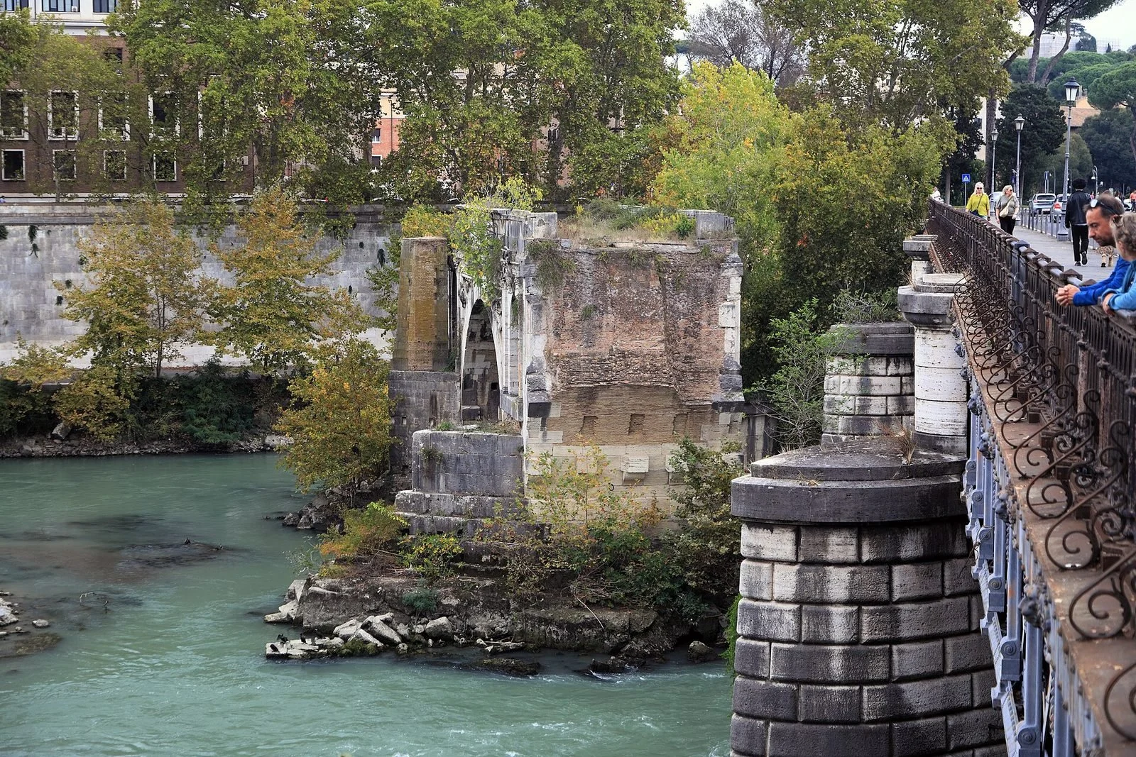
Ponte Palatino crosses the Tiber between Piazza della Bocca della Verità and Trastevere, and for once the most interesting thing is not the bridge: it's what you see from on top of it. From the parapet that looks toward the Tiber Island you frame the lone arch of the Ponte Rotto, that is, what remains of the Pons Aemilius, the first stone bridge built by the Romans on their river. On the other side open the Forum Boarium with its two Republican temples, the bell tower of Santa Maria in Cosmedin and the outlet of the Cloaca Maxima on the embankment wall. The present bridge dates from the years between 1886 and 1890, made precisely to replace the connection that the demolition of the Ponte Rotto had erased. It is also the only point in Rome where traffic keeps to the left, hence the nickname of the English bridge. You don't pay, there are no hours, there's nothing to reserve: you arrive and you cross. On the other hand it is a fast-moving, noisy bridge with narrow sidewalks, and it's good to know that before taking a child by the hand or setting up a tripod.
Where Ponte Palatino is and how to get there
Ponte Palatino links Lungotevere Aventino and Lungotevere dei Pierleoni, on the left bank, with Lungotevere Ripa on the right bank, at the start of Viale Trastevere. In practice it joins the corner of the Forum Boarium, where the Mouth of Truth and the Arch of Janus are, to the southern edge of Trastevere. Upstream, a few dozen meters away, are the Tiber Island with Ponte Fabricio and Ponte Cestio. Downstream, the river continues toward the Aventine and the Testaccio district.
On foot, which is the right way to get there
From the Colosseum it's a walk of a little under 20 minutes via Via di San Teodoro and Via del Velabro, with the Arch of Janus on the way. From the Capitoline Hill you go down toward the Theater of Marcellus and then along Via Petroselli: 10 minutes, slightly downhill, with the bulk of Santa Maria in Cosmedin as a visual reference. From Piazza Navona or the Ghetto it's better instead to follow the river, pass through the Tiber Island and reach the bridge from the Trastevere bank.
By public transportation
The metro stop closest to Ponte Palatino is Circo Massimo, on line B, about 10 minutes' walk along Via della Greca and Via Petroselli. On the Trastevere side the reference is the terminus of tram 8 in Piazza Venezia and its run along Viale Trastevere, which passes a couple of steps from the right-bank end of the bridge. The Lungotevere is served by city bus lines, among them the 23 and the 280, with stops on both lungoteveri close to the bridge, and Piazza della Bocca della Verità is served by the lines that pass along Via Petroselli. Atac lines and routes change often, especially in the summer months and during works on the lungotevere: we recommend checking the updated route before leaving.
By car, bike, scooter
You can get there by car, but it makes no sense. The bridge is inside or right next to the limited traffic zones of the historic center depending on the direction of travel, parking nearby is paid during daytime hours and free spots on Lungotevere Aventino are the exception, not the rule. Anyone coming from outside Rome is quicker leaving the car in a line B park-and-ride and finishing by metro.
By bike the picture changes. Ponte Palatino is one of the points where the bike path running along the Tiber embankments breaks off and forces you to climb back up to street level, and those who cycle along the river know it well for this reason. The ramps and access staircases to the embankments near the bridge are not always all usable, because after the winter floods the bank stays closed for mud cleaning, sometimes for weeks. Anyone planning a ride along the river should check the state of the embankments the same day.
Real accessibility
The roadway of Ponte Palatino is flat and the sidewalks are continuous on both sides, so the bridge itself can be crossed even in a wheelchair or with a stroller. The problems are the width and the traffic: the sidewalks are narrow, two people side by side fill them, and the flow of vehicles passes a few centimeters from the curb. The pedestrian crossings at the two ends have traffic lights but cross streams of traffic arriving from several directions, and at rush hour they require attention. Those with mobility difficulties will do well to choose the upstream side, the one that looks toward the Tiber Island, and to schedule the photo stop outside rush hour.
What Ponte Palatino is: a work of 1886-1890 on a very ancient ford
Ponte Palatino is a road bridge built between 1886 and 1890 as part of the Tiber embankment works, the ones that produced the retaining walls and lungoteveri we now take for granted. It's not an ancient monument, it has no statues, no famous inscriptions. It's late 19th-century infrastructure, designed to let people and carts cross where for centuries they had crossed on the Pons Aemilius, and built with the mixed technique that Italian engineering of those years normally used: a metal structure for the longer spans, masonry and stone facings for piers, abutments and parapets.
The design and the technical context
The sources attribute the design to the engineer Angelo Vescovali, a central figure in the Tiber works of that period and author of other interventions on the river in the same span of years. The building site belongs inside a much larger operation: after the flood of December 1870, which flooded half the city a few months after the breach of Porta Pia, the new State decided to channel the Tiber between two continuous walls. The general project bears the name of Raffaele Canevari, the works began in 1876 and went on for decades. Ponte Palatino was born inside that building site, not next to it.
On the exact number of spans and the dimensions of the bridge the available sources are not uniform, and we prefer not to report numbers we could not check against technical documentation. What you see by eye is clear: a deck fairly low over the water, supported by masonry piers, with continuous stone parapets and a roadway wide enough to hold several lanes per direction.
Why it's low and why it matters
The low height of the deck is a feature you notice at once, and it has a practical consequence that Romans know: during major floods the river comes to lap the underside of the arches, and the bridge becomes one of the points from which the severity of the event is gauged by eye. In ordinary floods of December and January the water rises onto the embankments and makes them impassable, floating material piles up against the piers, and the view from above changes completely: the river stops being the slow greenish ribbon you see in summer and becomes brown, fast, full of tree trunks.
The name
The name comes from the Palatine Hill, which rises a little to the east, beyond the Circus Maximus, and which is the most recognizable topographic reference of that sector of the city. There is no ancient link between the hill and this crossing: the name is modern, chosen at the time of construction according to a logic that in those years christened new bridges with names taken from topography or Roman history.
Why Ponte Palatino exists: the end of the Pons Aemilius
Ponte Palatino was built to replace a connection that had existed for more than 2,000 years and that the Tiber works were about to erase: the one provided by the Pons Aemilius, the bridge the Romans later called Ponte Santa Maria and that everybody now knows as the Ponte Rotto. This is the link that explains everything else, and that almost nobody tells you while standing at the parapet.
The first stone bridge in Rome
The Pons Aemilius was the first masonry bridge built by the Romans over the Tiber. The ancient sources place the construction of the piers in 179 BC, on the initiative of the censors Marcus Aemilius Lepidus and Marcus Fulvius Nobilior, and the completion of the arches in 142 BC, under the censorship of Publius Cornelius Scipio Aemilianus and Lucius Mummius. Before then the ford of the Forum Boarium had been served by the Pons Sublicius, the wooden bridge of the archaic tradition, the one tied to the story of Horatius Cocles. The passage from wood to stone, at that point, is both a technical and a political fact: it meant declaring permanent a crossing that until then had been, literally, dismountable.
The position was no accident. There the river narrowed and the Tiber Island a little upstream broke the current, making the stretch more manageable. On the left bank was the cattle market of the Forum Boarium, on the right the road that climbed toward Etruria. It was the point of contact between the city and the opposite bank, and the bridge served commercial traffic even before serving ceremonial traffic.
A thousand years of collapses
The story of the Pons Aemilius is a sequence of floods, failures and reconstructions. Augustus had it restored, and later restorations are documented in the imperial age. In the Middle Ages the bridge took the name Ponte Santa Maria, from the church of Santa Maria Egiziaca carved out of the Temple of Portunus, which stood next to it on the left bank. Partial collapses are recorded in 1230 and 1557. In 1575 Pope Gregory XIII financed an imposing reconstruction, celebrated by the inscriptions and coats of arms still visible on the surviving arch. 23 years later, in the flood of 1598, half the bridge was swept away.
From that moment the bridge was never rebuilt and the Romans began calling it what it was: Ponte Rotto, the broken bridge. It stayed that way for almost three centuries, a stump that started from one bank and didn't reach the other, with fishermen underneath and vegetable gardens around. It's the image found in the engravings of the 1700s and in the first Roman photographs of the 1800s.
Pius IX's footbridge and the demolition of 1887
In 1853 Pius IX had the surviving sections linked with a suspended metal footbridge, a light solution that gave pedestrians back the passage from one bank to the other without rebuilding the bridge. It lasted a little over 30 years. When the embankment works reached this stretch, the structure of the old bridge turned out to be incompatible with the new hydraulic section of the river, much narrower and deeper than the natural one: in 1887 the footbridge and two of the remaining arches were demolished, and of the whole Pons Aemilius only a single arch was left in the middle of the water, the one you see today.
That is the reason Ponte Palatino exists. It isn't a bridge added for convenience: it is the functional replacement of a suppressed crossing. The building of the new bridge and the demolition of the old one are two faces of the same intervention, and the dates say so clearly: 1886 the start of the works on the Palatino, 1887 the demolition, 1890 the new bridge entering service. Rome was left with a provisional crossing or with no crossing at this point for very few years.
What remains and how to read it
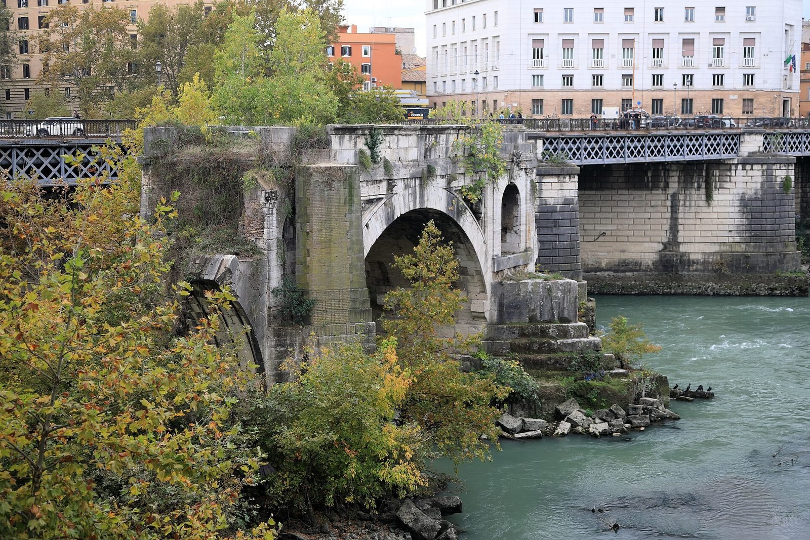
The surviving arch of the Ponte Rotto is a few meters from Ponte Palatino, on the side that looks toward the Tiber Island, isolated in the middle of the current and in contact with neither bank. On its flank you can still make out the block facing, the cornices and the coats of arms of Gregory XIII's reconstruction, and on top a small spontaneous vegetation has grown for decades that nobody removes. It is the only fragment of a Republican Roman bridge still visible in place on the Tiber, and that is why it's worth the detour even for those who aren't interested in bridges at all.
Anyone who wants to understand the difference between the two structures should look at them together, because they are there on purpose. On one side a pier and an arch in squared blocks, with the repairs of four overlapping eras. On the other a 19th-century deck, regular, repetitive, built in a few years. 2,000 years apart, a few dozen meters of water in between.
The English bridge: why traffic keeps left on Ponte Palatino
On Ponte Palatino vehicle traffic keeps to the left, that is, each stream of traffic occupies the carriageway that in the rest of Italy would be the opposite one. It is the only case in Rome and one of very few in Italy, and the nickname of the English bridge comes from this, not from some story of British engineers. The first time you cross by car or scooter the sensation is sharp: you enter the bridge and find yourself on the left of those coming the other way.
The technical reason
The current explanation, and the only one that stands up to the facts when you look at the plan, lies in how the bridge joins the two lungoteveri. At the two ends the bridge doesn't flow into an ordinary road but into fast-moving axes that run parallel to the river, with several lanes and with the access ramps to the embankments in the middle. If traffic kept right, every vehicle entering or leaving the bridge would have to cut across the opposing stream, at two points that are already dense, creating two conflicting intersections. By keeping left, on the other hand, each flow splits off and rejoins tangentially, from the side where it already is: the trajectories don't cross, they run alongside. It's a solution of road geometry, not a folkloric oddity.
As to when exactly this traffic arrangement was adopted, we haven't found a dated act that can be consulted: the reconstructions that circulate link it to the 1900s reorganization of the junction, but we can't point to a specific measure and prefer to say so. The fact itself, on the other hand, can be verified at any time: all you have to do is stand on the sidewalk and see which side the cars come from.
What it means for those who cross
For pedestrians the risk is real and needs saying plainly: the instinct to look left before crossing, which in Italy is the right one, on Ponte Palatino makes you look the wrong way. At the ends of the bridge, where the pedestrian crossings meet the ramps, it's best to look both ways twice. This applies above all to those coming from Trastevere in the evening, perhaps distracted, and to those with children in tow.
A curiosity about Ponte Palatino
The curiosity that holds up best is also the easiest to check: Ponte Palatino is the spot from which, without moving 10 meters, you can see at the same time a Republican bridge reduced to a single arch, the outlet of the oldest sewer works in the city and two Republican-era temples left standing almost by chance. There is no other parapet in Rome that holds together three things like this.
The outlet of the Cloaca Maxima
On the left bank, in the embankment wall a short distance from the bridge, opens the outlet arch of the Cloaca Maxima, the main drain that tradition dates to the age of the Etruscan kings and that drained the marshy area between the Palatine, the Capitoline and the Velabrum, making the zone of the Roman Forum buildable. The arch you see today is not the archaic original but the terminal reworked in Roman times and then rearranged with the 19th-century embankment wall. It can be made out well when the river is low, less so when the water is high. Anyone who wants to see it should lean over the parapet that looks toward the Tiber Island, staying close to the end on the Forum Boarium side, and look for the dark opening in the left-bank embankment wall: it's lower down than you'd expect.
The two temples of the Forum Boarium
A few meters from the left-bank end, inside the green area of Piazza della Bocca della Verità, stand the Temple of Portunus, rectangular, with Ionic columns in travertine and tuff, and the Temple of Hercules Victor, round, surrounded by Corinthian columns in Pentelic marble. Both are from the Republican age, both reached us because they were turned into churches: the first became Santa Maria Egiziaca, the second Santa Maria del Sole. The conversion to Christian places of worship is the reason they were not dismantled to obtain building material, a fate that befell almost everything else.
An overlay of eras you can read in 30 seconds
Standing in the middle of the bridge and turning a full circle, you see, in no particular order, the 6th century BC of the Cloaca, the 2nd century BC of the temples and the Pons Aemilius, the 12th-century Romanesque bell tower of Santa Maria in Cosmedin, the embankment walls and the bridge of the late 1800s, and the Umbertine buildings of Lungotevere Ripa. Anyone who brings someone here who is seeing Rome for the first time has a lesson in urban stratification in hand that needs no ticket.
One thing nobody tells you about Ponte Palatino
What nobody says is that Ponte Palatino is not a place to linger, and it's a mistake to treat it as one. It's a fast-moving artery with sidewalks barely over a meter wide, exposed to the continuous noise of traffic and, at rush hour, to a river of scooters passing 30 centimeters from the curb. Anyone arriving imagining a romantic stroll along the river realizes within two minutes that the stroll is elsewhere.
How much noise there really is
We don't report decibel measurements because we have no verified ones for this precise spot, but we're happy to describe the practical effect: at the middle of the bridge, during weekday daytime hours, two people side by side have to raise their voices to talk. Recording clean audio is out of the question. Anyone shooting video for social media should remember it, because it's the most frequent complaint of those who try.
The operational consequence: look and move on
The right way to use this bridge is to cross it, stop for two or three photographs on the upstream side and then go down. Below, on the Tiber embankments, when they are open and clean, the noise drops suddenly and the view of the Ponte Rotto arch improves because you gain the low viewpoint, the one from which the arch looks much bigger. Alternatively you move the stop to the Tiber Island, where the parapets are wide and you can lean without a bus at your back.
And the summer factor
In summer the opposite happens, and open-air events concentrate on this stretch of river. The festival Lungo il Tevere Roma occupies the embankments between Ponte Sublicio and Ponte Sisto for the whole season, with stalls, kiosks and platforms: it's a different stretch from that of Ponte Palatino, but the flow of people it generates is felt here too, and on August evenings the pedestrian passage toward the Tiber Island gets crowded. Anyone looking for the quiet river in August, in the evening, won't find it in this kilometer.
My advice for visiting Ponte Palatino
There is only one piece of advice and it goes against instinct: don't come to Ponte Palatino for Ponte Palatino, but build around it a 40-minute loop that takes in the Forum Boarium, the bridge, the Tiber Island and the return. On its own the bridge is worth 10 minutes. Inside a route it's worth a morning.
The loop we recommend
You start from Piazza della Bocca della Verità, look at the two Republican temples from outside, go into Santa Maria in Cosmedin if the line for the Mouth of Truth isn't impossible, walk 100 meters back up toward the Arch of Janus and San Giorgio in Velabro, then go down to the river and cross Ponte Palatino. On the Trastevere bank you turn right along Lungotevere Ripa, climb onto Ponte Cestio, cross the Tiber Island with a stop at San Bartolomeo all'Isola and come back to the left bank by Ponte Fabricio, which is the best-preserved Roman bridge in the city and still works after more than 2,000 years. From there the Ghetto is a couple of steps away.
Total time, walking without hurry and counting two stops: an hour and a quarter. Practically no change in elevation. Cost: zero, unless you go into somewhere that charges.
The right hour
For the light and for the traffic the best hour is the first of the morning, between 7:00 and 9:00: the cars are there but the sidewalk is free, the river is in sharp shade and the stone of the Ponte Rotto arch catches a raking light that reveals its facing. The second good window is the last hour before sunset, with the advantage that the temples of the Forum Boarium, oriented toward the river, receive light on the front. At noon, with the sun high, everything flattens and the green river turns gray.
A clear verdict, since one is needed
Among the bridges of central Rome, Ponte Palatino is overrated as a destination and underrated as an observation point. It has nothing to offer on its own: it's not Ponte Fabricio, which is ancient and can be touched, and it's not Milvian Bridge, which has a military history and a social life of its own. It is worth it for what it frames, namely a piece of Republican Rome in the middle of the water that you can't see so well from any other point. If you have two hours and must choose a single bridge to visit, choose Ponte Fabricio. If you have a camera, choose this one.
Another well-known fact, yet rarely cited
The well-known fact that almost nobody connects to Ponte Palatino is that the Tiber embankment walls, the work that made this bridge possible, wiped out the river Rome that existed until 1870. The bridge is the visible result of a destruction that can no longer be seen, and this is the key to understanding why the landscape around looks so abrupt.
What there was before the embankment walls
Before 1876 the banks of the Tiber in the center of Rome were open riverbanks: landings, stairs that went down into the water, floating mills anchored to the current, warehouses, vegetable gardens, houses facing directly onto the river. The city touched the water. The port of Ripa Grande, a little downstream on the Trastevere bank, was still an active landing for the traffic coming up from Fiumicino. After the embankment walls all this disappears: the river is boxed in between two high walls, the banks are demolished, the street level rises and the relationship between Rome and the Tiber is broken. Anyone leaning over the parapet of Ponte Palatino today looks at a canal, not an urban river.
The price and the reason
It would be wrong to tell the story of the embankment walls as mere vandalism. The floods of the Tiber regularly inundated the center of Rome: the one of December 1870 came to cover the streets and ground floors of half the city, and it was not an exceptional event in the river's statistics. The alternative to embankment was to keep living with periodic flooding in an urban center that was becoming a capital. The choice was drastic and it worked: since then Rome has not had a comparable flood. The cost was the landscape, and its measure can be read better here than elsewhere, because here the comparison between before and after has stayed in the water in the form of a broken arch.
Where you can see the before
The Rome on the river before the embankment walls can still be looked at in two ways. The first is the watercolors of the series Roma Sparita by Ettore Roesler Franz, painted between the late 1870s and the mid-1890s just as the works were going on, kept in Rome and largely on view at the Museo di Roma in Trastevere, a few minutes from here. The second is the 1700s engravings of Giovanni Battista Piranesi and the views of Giuseppe Vasi, which portray the Ponte Rotto when it still kept more arches. They are documents, not illustrations: the proportions are reliable and allow direct comparison with what remains.
The right photo to take at Ponte Palatino
The right photo at Ponte Palatino is just one: the arch of the Ponte Rotto isolated in the middle of the river, shot from the upstream parapet, with the Tiber Island and the profile of Trastevere in the background. It's the image that appears in half a century of Roman photography manuals, and it takes three minutes if you know where to stand.
Where to stand, exactly
On the upstream sidewalk, that is, the one that looks toward the Tiber Island, you move to about a third of the bridge's length starting from the Trastevere end. From there the arch stands apart from the embankment wall of the left bank and doesn't overlap either the piers of the bridge or the plane trees on the bank. Getting too close to the left end, the arch is squashed against the wall. Staying at the exact center of the bridge, the pier enters the frame. The third toward Trastevere is the best compromise.
The parapet is high and in solid stone, so the lens has to be brought above the handrail: with a bulky reflex camera you need to raise your arms, with a phone you can just rest it on the edge. A tripod, on this bridge, is a complication: it takes up half the sidewalk and at traffic hours becomes a problem for those passing. If you need stability, it's better to rest the camera directly on the stone of the parapet.
Which light to choose
The front of the arch that you see from the bridge gets sun for a large part of the day, and that helps. The first hour of light, with the sun still low in the east, gives a raking angle that brings out the blocks, the cornices and the 1500s coats of arms on the flank: it's the condition we recommend to anyone who wants to read the structure. The last hour before sunset instead gives a warmer light and a more interesting sky behind the subject, because the background of the shot faces northwest. In the middle of the day, with the sun directly overhead, the arch loses volume and the river goes dull.
The other three framings that are worth it
The second photo is that of the two temples of the Forum Boarium, taken from the left end looking toward Piazza della Bocca della Verità: the round Temple of Hercules Victor in the foreground and that of Portunus to the side. It works in the late afternoon, when the front is lit, and the presence of the trees has to be taken into account, which in June cover much more than in February.
The third is the outlet of the Cloaca Maxima in the embankment wall of the left bank: you need a modest telephoto lens or the zoom of a recent phone, and you need the river low, a typical condition of July and August. With high water the opening is reduced to a dark line.
The fourth isn't taken from the bridge but from below: once down on the embankment, when it's open, you gain the low viewpoint and the arch of the Ponte Rotto takes on a completely different scale, with the modern bridge entering the frame as a backdrop above. It's the version you see least around, and for that reason it's the one we recommend to anyone coming back a second time.
What doesn't work
What doesn't work, or works badly, is the handheld night photo: the public lighting on the bridge is calibrated for the roadway and the subject in the water is underexposed, while the streetlights enter the frame and burn out. The clean framing of the bridge itself doesn't work either, because from every angle signs, poles and traffic get in. Anyone who wants a portrait of a photogenic Roman bridge should go to Ponte Sisto or Milvian Bridge, which lend themselves much more.
Some important events that happened here in history
The events that matter at this point of the Tiber almost all concern the crossing and the river, not the present bridge, which has little history and a recent one. We put them in order, because read in sequence they tell a single story 22 centuries long.
179 and 142 BC: the first stone bridge
The construction of the piers of the Pons Aemilius in 179 BC and the completion of the arches in 142 mark the moment when Rome decides to join the two banks permanently at the point of the cattle market. It is a public work of the full Republican age, contemporary with the great building season that in the same sector produces the two temples of the Forum Boarium.
1575: Gregory XIII's reconstruction
In the Jubilee year 1575 Pope Gregory XIII finances a substantial reconstruction of the bridge, celebrated by the inscriptions and coats of arms that can still be read today on the flank of the surviving arch. It is the last successful attempt to keep the ancient crossing standing.
1598: the flood that breaks the bridge
The flood of 1598, one of the most severe in the documented history of the Tiber, carries away a considerable part of the structure. From that moment the bridge is never rebuilt and for the Romans it simply becomes the Ponte Rotto. The name has held for over 400 years and has entered current place-naming.
December 1870: the flood that changes everything
A few months after the annexation of Rome to the Italian State, the flood of December 1870 inundates a large part of the center. It is the event that convinces administrators and engineers to proceed with boxing in the river between continuous embankment walls, a decision from which everything you see today in this stretch descends.
1886-1890: the Ponte Palatino building site
The works on the new bridge take place between 1886 and 1890, inside the general building site of the Tiber reorganization. In 1887 the footbridge and two of the remaining arches of the Ponte Rotto are demolished, leaving in the water the single span that we know. The bridge enters service as a functional substitute for the lost crossing.
The 1900s: traffic
During the 1900s the lungotevere is transformed into a fast-moving axis and Ponte Palatino becomes one of the nodes of urban traffic between the historic center and Trastevere. It is in this phase that left-hand traffic is consolidated and that the bridge acquires its present appearance, that of a service infrastructure more than a place. On the specific measures of this phase we have no verifiable dated references, and we point it out.
Who passed through Ponte Palatino
On a road bridge open since 1890, millions of anonymous Romans have passed, and this is the basic fact. The names that make sense to mention are those of the people who designed, documented or narrated this crossing, and who left something verifiable here.
Angelo Vescovali
The sources attribute the design of the bridge to him. Vescovali is one of the engineers who work on the Tiber reorganization in the two decades after 1870, a technical generation that redrew the relationship between Rome and its river on hydraulic and not landscape criteria. The judgment on the result is still debated today, and there is no reason to hide it.
Ettore Roesler Franz
A Roman painter from a family of foreign origin, between 1878 and 1896 he produced the series of watercolors known as Roma Sparita, devoted to the places of the city that the works were erasing. The stretch of river between the Forum Boarium and Trastevere is among the recurring subjects. His plates are today the main visual source for understanding what this bank was like before the embankment walls, and many can be seen at the Museo di Roma in Trastevere.
Giovanni Battista Piranesi and Giuseppe Vasi
In the 1700s both engraved views of the Ponte Rotto, when the stump still kept more than one arch and boats and mills passed beneath. Piranesi works on monumentality and forces the proportions, Vasi documents with topographic precision: the comparison between the two ways of seeing the same subject is instructive, and anyone who makes it understands how much taste influences the images we use as evidence.
And the herdsmen of the Forum Boarium
Before all of them, and for centuries, the herdsmen who brought cattle to market passed here, along with the boatmen coming up from Ripa Grande and the millers of the mills anchored to the current. They left no names. They left the reason why a bridge, at this precise point, was built three times in 22 centuries.
What's around Ponte Palatino
Around Ponte Palatino, within a kilometer, there are more freely accessible monuments than in almost any other sector of the center of Rome. Anyone who comes here for the bridge should get off the bridge: the value of the zone is all in the surroundings.
On the left bank: Forum Boarium and Aventine
The left end opens directly onto the Forum Boarium, with the two Republican temples, the Arch of Janus, San Giorgio in Velabro and the basilica of Santa Maria in Cosmedin with the Mouth of Truth in the portico. From there you climb toward the Circus Maximus and the Palatine, or go up the Aventine to the Orange Garden, the Basilica of Santa Sabina and the Rome Rose Garden, open only in the blooming season. Continuing south you reach the Pyramid of Cestius, the Non-Catholic Cemetery, Monte dei Cocci and the Nuovo Mercato Testaccio.
Toward the north: Tiber Island, Ghetto, Capitoline Hill
Going up the river you soon meet the Tiber Island with its two ancient bridges, then the Jewish Ghetto with the Synagogue, the Theater of Marcellus and the climb to the Capitoline Hill with the Capitoline Museums. A little further on opens the sacred area of Largo Argentina. In 20 minutes on foot from the bridge you reach the Roman Forum.
On the right bank: Trastevere
The right end delivers you directly to Trastevere. In a few minutes you reach the Basilica of Santa Cecilia, the church of San Francesco a Ripa and, further downstream, the Porta Portese market, active on Sunday mornings. Toward the center of the district you reach the Basilica of Santa Maria in Trastevere and the Museo di Roma in Trastevere. Climbing further you reach the Botanical Garden and the Janiculum, with the Acqua Paola Fountain.
How to fit it into a day
If you have only one day and want to spend your hours well, put Ponte Palatino in the middle of the morning, after the Forum Boarium and before the Tiber Island, and keep the afternoon for the Aventine or the Baths of Caracalla. If you travel with children, find more guidance on our page on Rome with kids, and if you want to keep the budget low, on the one about free Rome: this bridge and everything it frames fall into the second category.
Eating around Ponte Palatino: how to choose
Around Ponte Palatino you eat badly with impressive ease, and not for lack of places: for an excess of them. The two ends of the bridge face two zones with very heavy tourist traffic, the Forum Boarium on one side and the start of Trastevere on the other, and this produces the kind of offering that lives on customers who won't come back. We don't name signs, by choice: a list gets old in a few months and teaches nothing. We give the criteria instead, which stay valid.
The five signs that point to a trap
The first sign is the lady rolling out fresh pasta in the window or at a little table on the street. It's a lure for passersby, not a kitchen: the pasta that reaches the plate is almost never that one, and the real craft isn't done in a window.
The second is the menu with photographs of the dishes, inside or outside. It's for those who don't know the names and won't come back, and it almost always goes with a menu translated into six languages with the same 50 dishes that you find 300 meters further on.
The third is the barker at the door, the one who invites you to sit down while you walk. A place that has to stop people in the street has a filling problem, and the problem is never the kitchen.
The fourth is the all-day schedule from morning to night, with no break between lunch and dinner. A kitchen that works well closes in the afternoon, because it has to prepare. Whoever stays open all the time serves things already made.
The fifth concerns the location: places set in front of famous monuments. Here it means the terraces with a view of the Forum Boarium or the river. The price in there follows what you see from the table, and the price list can change between inside and outside, with items without prices and surcharges that appear only on the bill. It's best to ask the price before sitting down, always.
The downtown franchises
Within the radius of this bridge there are, as in all of central Rome, chains with the same sign repeated in several places, identical menu and a line with ticket numbers at the entrance. They work because they're reassuring and because they show up at the top of search results. The thing to keep in mind is simple: Romans don't go there. It's not a question of personal taste, it's that at those prices and in those portions a Roman knows they can eat better 200 meters away, in a place that doesn't need a line to fill up.
The criterion that always works
The simplest criterion remains looking at who is seated and what language they order in. If at 2 p.m. the tables are occupied by people speaking Italian whom nobody stopped in the street, the place holds up. If they are all foreigners with a camera on the table, you walk another five minutes. In Rome five minutes on foot completely changes the picture, and in this area they are enough to get out of the cone of tourist traffic toward the interior of Testaccio or toward the upper part of Trastevere.
If you want an already selected reference, you can consult Daniele Dezi's personal list on Google Maps: it's a curated collection, built over the years in the field, unsponsored and with no commercial agreements with the places listed. For the general picture of the city's food markets, which remain the cheapest way to eat well, we refer you to our page on the markets of Rome.
Frequently asked questions about Ponte Palatino
How much does it cost to visit Ponte Palatino?
Visiting Ponte Palatino is free, because it is a public road bridge and not a site with a ticket office. There are no entrances, hours or reservations: you get on from Lungotevere Aventino on the left bank or from Lungotevere Ripa on the Trastevere side, at any hour of the day and night. The only possible expense is the public transportation ticket to get there.
Why is Ponte Palatino called the English bridge?
Ponte Palatino is called the English bridge because it is the only bridge in Rome on which vehicle traffic keeps to the left. The reason is road geometry: the bridge joins two fast-moving axes parallel to the river, and driving on the left lets each flow split off and rejoin without cutting across the opposing stream at the two ends. The nickname is popular, not official.
What is the relationship between Ponte Palatino and the Ponte Rotto?
Ponte Palatino was built between 1886 and 1890 to replace the connection provided by the Pons Aemilius, now known as the Ponte Rotto, when the embankment works made it necessary to demolish its surviving parts. In 1887 the 19th-century footbridge and two arches were torn down, and of the whole ancient bridge only the single arch you can still see today next to the modern bridge was left in the middle of the river.
When was Ponte Palatino built?
Ponte Palatino was built between 1886 and 1890, inside the general building site of the Tiber reorganization begun in 1876 after the flood of December 1870. The sources attribute the design to the engineer Angelo Vescovali. The structure is of the mixed type used in those years, with a metal deck for the longer spans and masonry and stone facings for piers, abutments and parapets.
What can you see from Ponte Palatino?
From Ponte Palatino you see the surviving arch of the Ponte Rotto in the middle of the river, the Tiber Island with Ponte Cestio behind it, the outlet of the Cloaca Maxima in the embankment wall of the left bank and, toward Piazza della Bocca della Verità, the two Republican temples of the Forum Boarium dedicated to Portunus and to Hercules Victor. The best parapet is the one that looks toward the island.
How do you get to Ponte Palatino by public transportation?
You get to Ponte Palatino by metro line B, Circo Massimo stop, about 10 minutes on foot, or by the buses that run along the lungotevere and Via Petroselli, among them lines 23 and 280. On the Trastevere side the reference is tram 8, which runs along Viale Trastevere a few meters from the right-bank end. Atac routes and stops change often: it's best to check them before leaving.
Is Ponte Palatino suitable for children?
You can cross Ponte Palatino with children, but its layout has to be kept in mind: the sidewalks are narrow, the traffic is continuous and the parapet is high and solid, so a small child can't see the river without being lifted. At the ends, moreover, traffic comes from the opposite side to the one you're used to. For a quiet stop it's better to move to the Tiber Island, two minutes away.
Can you go down to the Tiber embankments under Ponte Palatino?
Under Ponte Palatino you can go down to the Tiber embankments when they are open, using the ramps and access staircases along the embankment wall. Opening is not guaranteed all year: after the winter floods the banks stay closed for weeks for mud removal. If you want the low viewpoint on the arch of the Ponte Rotto, check the state of the embankments the same day.
Can you take photographs at Ponte Palatino?
You can photograph freely at Ponte Palatino, since it is an outdoor public space with no filming restrictions. The only limitation is practical: the sidewalk is narrow and a tripod obstructs it, so it's better to rest the camera on the stone parapet. The best light for the arch of the Ponte Rotto is the first hour of the morning, with the low sun bringing out the facing.
Who wrote this page
This page is edited by the team of Tour Leader Pro, the Roman project office that designs and coordinates visits, itineraries and cultural events in Rome and Lazio. The hours, fares and access conditions reported here are verified as of the publication date against the official sources indicated in the text: before leaving it's best to check them again, because they change often. If you find a piece of data that isn't up to date, let us know.
Anyone building an itinerary in the center of Rome that puts together the Forum Boarium, the bridges over the Tiber and Trastevere, and wants to fit the stops around hours, travel times and guided visits, will find planning tools and operational support at Tour Leader Pro, which works in Rome and Lazio with groups, schools and corporate trips.
For the wider picture, that is transport between Italian cities, travel times and destinations beyond Lazio, a good planning resource is Italy Planner, especially useful for those who set Rome inside a multi-stop trip and need to work out how much time to give each one.