Ponte Rotto at Tiber Island
In short. There are monuments that explain themselves and monuments that need someone to tell their story.

Ponte Rotto at Tiber Island: A Single Arch in the Middle of the River
There are monuments that explain themselves and monuments that need someone to tell their story. Ponte Rotto at Tiber Island belongs, with all the weight of its stone, to the second category. Anyone who crosses Ponte Palatino on a bus, with a fogged window and their head elsewhere, sees on the right a piece of masonry sticking out of the water, covered in weeds, and at best thinks of some random ruin, one of the many that pop up everywhere in Rome like mushrooms after the rain. And yet it's worth stopping: what you have in front of you is the oldest fragment of a Roman bridge still visible on the Tiber, and it is all that remains of the first masonry bridge Rome ever built for itself.
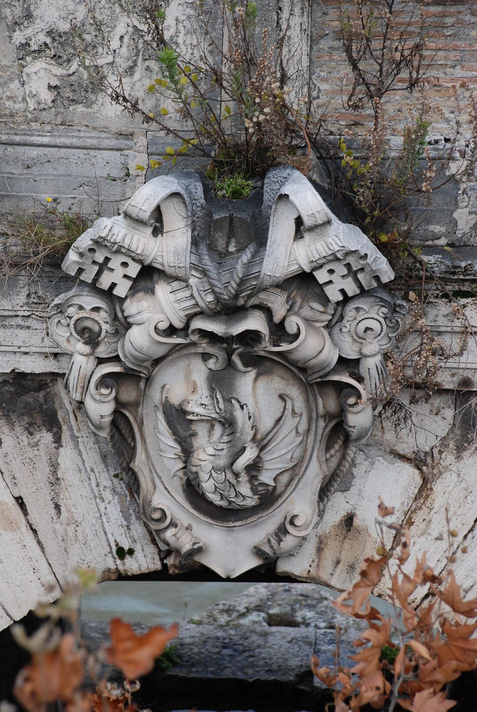
The extraordinary thing is not the size. It's tiny compared to any other ruin in the city: one span, two piers, a stretch of parapet, an eroded plaque, a tuft of capers that in summer becomes an accidental little hanging garden. The extraordinary thing is that the arch stands there, in the middle of the current, touching neither bank. It leads nowhere. It serves no purpose. It's a bridge that stopped being a bridge and started being an image, and this change of state, this transformation of an infrastructure into a symbol, happened on Christmas night of 1598, when the Tiber took three arches and never gave them back.
From that moment on the Romans stopped calling it by its official names, which had been many, and we'll see which, and called it what it had become: broken. There is no name more Roman than this. No rhetoric, no dedication to a consul or a pontiff, no attempt to ennoble the defeat. The bridge broke, so it's called Ponte Rotto. Period. And the fact that this popular nickname has definitively displaced the learned designations, so much so that it ended up in guidebooks, in cadastral maps and even in current street naming, is the best lesson in urban anthropology this city can offer in 50 meters of riverbank.
Why I Call It Ponte Rotto at Tiber Island
The full name I use, Ponte Rotto at Tiber Island, has a practical reason before even a topographical one. In Rome there have been quite a few broken bridges, in the literal sense, and at least one other officially bore that name for centuries. Specifying "at Tiber Island" serves to plant a precise geographical flag: we are a little downstream of the island, in the stretch of river between the southern tip of the Insula and Ponte Palatino, in what was Rome's oldest commercial landing. If you look for the monument starting from the Bocca della Verità you find it in three minutes. If you start from the Ghetto it takes the same time. If you start from Trastevere you only have to cross.
Then there is an emotional reason. The surviving arch and the Tiber Island form an inseparable visual pair. If you stand at the parapet of Ponte Palatino, looking upstream, you have in a single glance the stump in the foreground, the elongated silhouette of the island behind it, and at its sides two ancient bridges still perfectly in use. It's the only point in the city where you can see at the same time one dead Roman bridge and two living Roman bridges. No museum offers you a comparison like that: time passing and time resisting, in the same frame, free, 24 hours a day.
What You Really See Today When You Look at Ponte Rotto at Tiber Island
I want to be precise about what is in front of you, because the stratigraphy of this monument is more complicated than it seems and hasty captions end up confusing the eras. The submerged part, the massive piers that sink into the current and split its flow into two tongues of foam, belong to the Roman republican bridge: 2nd century BC, ancient masonry, the work of men who spoke Latin and counted the years from the founding of the city. The arch resting on those piers, on the other hand, is not Roman: it is 16th-century, the result of the last great papal reconstruction. So you are looking at a composite object, a graft: republican foundations and a Renaissance arch, welded together and having survived together.
Above the arch runs a stretch of parapet and, set into the wall, a plaque with the coat of arms of the pope who wanted that restoration. The travertine is eaten away by time and damp, and the letters are hard to read even with a telephoto lens, but they are there. On the sides grow capers, wild figs, grasses: the ruderal vegetation that in Rome colonizes every porous surface left in peace. On flood days, when the river rises and turns the color of milky coffee, the water climbs up to lapping the springing of the arch and the stump looks like a little ship about to be submerged. In the summer low waters, on the other hand, the blocks emerge at the base and you sense the power of those foundations.
Where to find Ponte Rotto dell'Isola Tiberina and how to get there
The location is simple to describe and surprisingly easy to miss. The stump is in the Tiber, immediately upstream of Ponte Palatino, the modern bridge that connects Lungotevere dei Pierleoni and the Forum Boarium area with Piazza Gioachino Belli in Trastevere. If you are crossing Ponte Palatino toward Trastevere, Ponte Rotto is on your right, a few dozen meters away, so close it seems you could touch it. If you are heading toward the center, it is on your left. In both cases the sidewalk of Ponte Palatino is the natural balcony, and it is from there that 90 percent of the photographs you see around are taken.
The walking access points
The nicest way to get there is from the Forum Boarium. Start from the Bocca della Verità, under the portico of Santa Maria in Cosmedin, walk toward the river keeping the little round temple of Hercules Victor and the temple of Portunus on your left, cross the lungotevere at the pedestrian crossing, and you are at the start of Ponte Palatino. It is less than five minutes of walking, but five minutes that cross 2,500 years of commercial history, because that patch of land was the river port of Rome when Rome was still a big village of huts.
The second access is from the Ghetto: go down from Portico d'Ottavia, reach Lungotevere de' Cenci, take Ponte Fabricio, cross Tiber Island, and from there you have two options: go down to the quay below the island, or climb back up and continue along Lungotevere degli Anguillara to Ponte Palatino. The third access is from Trastevere, from Piazza in Piscinula or Piazza Gioachino Belli, and in this case you will see the monument backlit in the afternoon, which has its dramatic advantages and its technical disadvantages.
The quay level
There is also a fourth route, which I recommend to anyone with legs and curiosity: going down to water level. The ramps leading to the nineteenth-century quays open at several points along the lungotevere, and walking down there completely changes your perception of the monument. From above, from the parapet of Ponte Palatino, Ponte Rotto looks like a small, almost decorative object. From the quay, with the embankment wall behind you towering over you by about 10 meters and the river flowing at arm's length, you finally grasp the scale of those piers and the violence of the water that has besieged them for 20 centuries. I warn you: after floods the quays stay muddy and slippery for weeks, and in those periods it is better to look from above.
The Pons Aemilius: Rome's first masonry bridge
The ancient name of Ponte Rotto dell'Isola Tiberina is Pons Aemilius, Ponte Emilio. And it is a name that carries a record with it: it was the first masonry bridge that Rome built over its river. Before it, the Tiber was crossed on wood, and this detail, which to us seems a technical note, for the Romans was a religious, political and military matter all at once.
Why stone was a revolution
A wooden bridge is built quickly, costs little and is easily repaired. But it has two flaws: it burns and it floats away. The Tiber, before the nineteenth-century regulation, was a river with a violent torrential regime, able to rise by several meters in a few hours after the autumn rains on the Apennines. A wooden deck, however well made, in the face of a major flood became a mass of drifting beams. Stone, on the other hand, resists, but it demands hydraulic knowledge that the Romans of the early republic simply had not yet developed to the necessary level, and above all it demands a capacity for public spending that a city in permanent war with its neighbors could not afford.
When Rome decides to build a stone bridge over the Tiber, then, it is not carrying out ordinary maintenance work: it is declaring something. It is saying that the river is no longer a border or even an obstacle, but an element inside the city, to be crossed permanently, forever. It is saying that the right bank, Trastevere, the Janiculum, the route toward Etruria, is now fully Roman territory and deserves a permanent link. And it is saying, in a slightly swaggering way, that it has the money and the engineers to do it.
The question of the date: 241, 179 or 142 BC?
Here I have to be honest about the uncertainties, because Ponte Rotto is one of those monuments scholars have argued over for centuries without reaching a unanimous conclusion. The traditional version, the one you will find in most captions, attributes the piers to the censors Marcus Aemilius Lepidus and Marcus Fulvius Nobilior in 179 BC. It is the most cited date, and it is the one that gives the bridge its name: Aemilius, after Emilio.
But some scholars, on the basis of passages from Livy and Plutarch and of a depiction on a coin, have proposed an earlier dating, around 241 BC, linking the construction to Manlius Aemilius Lepidus and to the building of Via Aurelia. In this reconstruction, 179 would not be the date of founding but that of a reconstruction, carried out together with the rebuilding of the nearby river port. The two hypotheses don't entirely exclude each other: an older first structure, then rebuilt in grand style at the beginning of the 2nd century, is a scenario perfectly compatible with Roman building history, which rarely builds from scratch and almost always reuses.
On one date, however, there is consensus: 142 BC. In that year the censors Publius Cornelius Scipio Aemilianus and Lucius Mummius Achaicus replaced the original wooden walkway with masonry arches. This is the decisive step: until then the bridge was a hybrid, stone piers and a wooden roadway. From 142 it becomes an entirely masonry bridge, the first in Rome in the full sense of the term.
Two Names Worth a Lesson in Roman History
It's worth pausing a moment on the two censors of 142, because they are not just any names. Publius Cornelius Scipio Aemilianus is the man who in 146 BC had razed Carthage to the ground, ending the Third Punic War. He is the protagonist of the famous story in which, before the burning city, he quotes Homer and weeps at the thought that one day the same fate will befall Rome. Lucius Mummius Achaicus, in that same 146, had destroyed Corinth, closing the Greek question and pouring onto Rome such a quantity of Hellenistic works of art that the taste of the ruling class changed forever.
Two men who had just wiped the two richest cities of the Mediterranean off the face of the earth find themselves, a few years later, serving as censors and dealing with public works. The money that pays for the arches of the Ponte Emilio is, in all likelihood, plunder money. When you look at those piers in the middle of the Tiber you are looking, in a sense, at the conversion into infrastructure of two Mediterranean catastrophes. I find it one of the most instructive connections you can make in all of Rome, and you won't find it written on any sign.
The Pons Sublicius and the Prehistory of Ponte Rotto at Tiber Island
To understand why the Ponte Emilio is born exactly there, and not 200 meters farther up or down, we have to talk about its predecessor: the Pons Sublicius, the wooden bridge, the oldest in Rome. It stood a little farther downstream, in the same stretch of river, and tradition attributes it to King Ancus Marcius.
A Bridge Without Nails
The Sublicius had a feature the Romans considered sacred: it was built entirely of wood, with no metal elements. The name itself comes from sublicae, the wooden stakes driven into the riverbed. Its maintenance was the responsibility of the college of pontiffs, and the term pontifex, bridge builder, probably derives precisely from this function. The head of Roman religion, and then by linguistic inheritance the head of the Catholic Church, bears a title that is born from the upkeep of a wooden walkway over the Tiber. It's a piece of news that leaves a few seconds of silence.
The Sublicius is also the stage of the most famous military legend of archaic Rome: Horatius Cocles defending it alone against the Etruscans of Porsenna while his comrades demolish it behind him, and then throwing himself into the river in full arms and reaching the bank by swimming. A founding tale, probably invented out of whole cloth, but revealing: the point where the river is crossed is the point where the city defends itself. Whoever controls the ford controls Rome.
Why the Ford Is Exactly There
Geography explains everything. In that stretch the Tiber Island splits the current into two arms, reducing the width to be crossed and offering a natural support halfway. A little downstream, the bed widens and the bottom rises, creating the conditions for a practicable ford in low-water conditions. It was there that the transhumance tracks and the salt road passed, the route that went up from the salt pans at the mouth toward the Sabine country, crossing the river. It is there, consequently, that the first market, the first port and the first commercial core of the city develop.
Ponte Rotto at Tiber Island, in short, was not born in just any place: it was born at the zero point of the economic Rome, in the place where the city began to be a hub of exchange before it was even a power. Every stone of those piers rests on a geographical choice made centuries earlier by shepherds and merchants following the most convenient path.
The Foro Boario: The District Where Ponte Rotto at Tiber Island Is Born
You can't understand the Ponte Emilio unless you understand where it landed. The head of the left bank opened onto the Foro Boario, the cattle market, and a little farther on onto the Foro Olitorio, the vegetable market. They were the two commercial poles of archaic and republican Rome, and they were there for the most banal reason in the world: they were next to the port.
The River Port and the Emporium
Goods arrived from the sea by going up the Tiber on shallow-draft boats, sometimes towed from the banks with ropes and oxen. They unloaded onto the quays of that stretch and ended up immediately on the market stalls. With the expansion of trade the system moved farther downstream, where the Emporium rose, the great commercial port at the foot of the Aventine, and where centuries of broken oil amphorae piled up formed Monte Testaccio, an artificial hill made entirely of shards. But the original core is still there, in the shadow of the piers of the Ponte Emilio.
This is why the report that the bridge was rebuilt in 179 BC "on the occasion of the rebuilding of the nearby river port" is more significant than it seems: bridge and port are a single system. You don't touch one without touching the other. The two works are part of the same infrastructure investment, exactly like a port and its highway connector today.
The Temple of Hercules Victor
A few steps from the bridge is the little round temple that everyone mistakenly calls the temple of Vesta. It is actually the temple of Hercules Victor, and it deserves a stop for at least three reasons. First: it is the oldest marble building preserved in Rome, built with Pentelic marble from Greece, in an era when marble was still an exotic and very expensive material. Second: it has a circular plan with a ring of Corinthian columns, a Greek type transplanted into the commercial heart of the city. Third: Hercules was the patron of merchants, and his presence at that precise spot confirms the vocation of the district.
The confusion with Vesta comes from the round shape, because the temple of Vesta in the Roman Forum is also circular. But the dedication to Hercules is now established, and the story of the error is instructive in its own way: it shows how much the ancient topography of Rome has been reconstructed through attempts, corrections and second thoughts, often centuries apart.
The Temple of Portunus
Next to it, rectangular and extraordinarily intact, is the temple of Portunus, dedicated to the god of ports. Here too the dedication speaks clearly: we are in a port area, and the tutelary deity is the one who protects the moorings. Its exceptional preservation is due to the fact that it was turned into a church in the Middle Ages, like so many other ancient buildings: Christianization, which is often told as destructive, in many cases was the best insurance policy a pagan building could take out. A temple converted into a church keeps being maintained, roofed, repaired. An abandoned temple becomes a quarry for material.
Santa Maria in Cosmedin and the Bocca della Verità
On the other side of the square, with its Romanesque bell tower of seven tiers of mullioned windows, stands Santa Maria in Cosmedin. It is one of the most beautiful and best balanced medieval churches in Rome, with a Cosmatesque floor that alone would justify the visit, a raised choir, and a schola cantorum that lets you understand how a liturgy worked before the modern reforms. The name "in Cosmedin" alludes to the decoration, and reflects the presence of Greek communities in the area.
Under the portico is that large marble disk with the bearded face and the open mouth that is probably the most photographed object in Rome after the Colosseum: the Bocca della Verità. In all likelihood it was a drain cover, or rather the lid of an ancient drainage system, perhaps tied to the sewer network of the area. The legend that it cuts off the hands of liars is medieval, and 20th-century cinema made it worldwide. One thing to know: the line to stick your hand in that mouth is almost always longer than the line to see the interior of the church, which is infinitely more interesting. It is one of the most eloquent paradoxes of contemporary tourism, and it plays out 200 meters from Ponte Rotto at Tiber Island.
The Cloaca Maxima Next to Ponte Rotto at Tiber Island
If from the parapet of Ponte Palatino you look at the left bank, just downstream of the stump, you spot in the embankment wall a large walled-up arch: it is the outlet of the Cloaca Maxima, the monumental sewer of Rome. It is not a detail. It is one of the most important pieces of engineering of antiquity, and it sits there, within sight, ignored by almost everyone.
From Stream to Sewer
The Cloaca Maxima began as the channeling of a natural watercourse that drained the valley between the Palatine, the Capitoline and the Quirinal, the marshy depression that would become the Roman Forum. Tradition attributes the work to the Tarquins, the Etruscan kings, and the substance of the story is credible: the reclamation of that valley is the material precondition for the birth of Rome as a city. Without draining the valley floor there is no Forum, without the Forum there is no public life, without public life there is no res publica.
At first it was an open-air canal. Only later was it covered and turned into the vaulted tunnel of which walkable stretches remain. Its final outlet, after a course of more than a kilometer under the monumental center, is right there, next to our bridge. Every time I point to that arch I say the same thing: Roman civilization produced temples, triumphal arches and statues, but its real political invention was the management of water, coming in with the aqueducts and going out with the sewers.
Two Goddesses and a Sewer
There's a detail I love to tell. The Romans deified the sewer: the goddess Cloacina had her own shrine in the Forum, above the route of the conduit. A divinity of the sewage system, with regular public worship. It's the kind of thing that dismantles the solemn, marble image we have of antiquity and returns it to its concreteness. A city that venerates its own drainage system is a city that has understood where public health comes from.
Why the Outlet Is Where It Is
The placement of the Cloaca's outlet in exactly that stretch is not accidental, and it is connected to the hydraulic logic of the whole bend. There the river had a current strong enough to carry away the wastewater and a level compatible with the gradient of the tunnel. The result is that within a radius of 200 meters you find, almost comically, the port, the market, the merchants' temples, the first stone bridge and the sewage outflow of the capital. If I had to choose a single point in Rome to explain to someone how an ancient city works, I would choose this one, and I would stay there with my back against the parapet looking at Ponte Rotto at Tiber Island.
The Tiber Island: The Stone Ship Moored in the Tiber
Going 100 meters up the river you reach the silent protagonist of this whole story: the Tiber Island, the only urban island on the Tiber, a lens of land of a little more than a hectare and a half, about 18,000 square meters, wedged between the two banks.
Tarquin's Grain
The founding legend is one of the most beautiful in the Roman repertoire. When in 510 BC the Romans drove out Tarquin the Proud, the last king, they threw into the river the sheaves of wheat harvested in the fields he owned on the Campo Marzio, because nobody wanted to eat the tyrant's stuff. The grain settled on the bottom, held back the silt, and on that bank the island grew. Modern studies indicate that the island is much older than that episode, but the legend still deserves to be told, because it says something true in a false form: that island is the product of the river, of its deposits and its whims, not of a human decision.
Aesculapius and the Serpent
In 292 BC Rome was struck by a plague. The Sibylline Books indicated the solution: bring to the city the cult of Aesculapius, the Greek god of medicine, venerated at Epidaurus. An embassy was sent, and tradition says the god boarded in the form of a serpent and that, when the ship reached Rome, the serpent threw itself into the water and reached the island. The temple was built there, and from that moment the island became the place of healing. In the first half of the 1st century BC it was monumentalized in ashlar masonry and given the shape of a ship, with travertine blocks covering a peperino core, decorations with Aesculapius and his serpent and a bull's head. Traces of the prow of that stone ship are still visible on the downstream tip.
The continuity is the most astonishing part. On the island today there is still a hospital, the Fatebenefratelli, and there is the basilica of San Bartolomeo all'Isola. A place dedicated to healing for more than 2,300 years, without substantial interruptions of function. I don't know many other examples in the world of such a stubborn use. When from the parapet I look at the island behind the arch of Ponte Rotto at Tiber Island, I always think that it is the longest chain of functional continuity in the city.
Inter duos pontes
In the Severan Forma Urbis, the great marble plan of Rome, the island appears with the definition "inter duos pontes," between two bridges. It is a turn of phrase that stays stuck to the island for centuries and defines it better than any place name: the island is not an isolated place, it is a doubly connected place. And the two bridges that connect it are still the same ones.
The Ponte Fabricio of 62 BC, Next-Door Neighbor of Ponte Rotto at Tiber Island
If the Ponte Emilio is the bridge that gave up, the Ponte Fabricio is the bridge that never gave up. It connects the Tiber Island to the left bank, at the level of Lungotevere de' Cenci, and it is the oldest bridge in Rome preserved in its original configuration. It measures about 61.8 meters in length and 6 in width, with two main spans and a maximum span of about 24.50 meters, in tuff, travertine and brick.
The Four Inscriptions
On the arches run four inscriptions attesting the construction by Lucius Fabricius, curator of the roads, in 62 BC. A smaller inscription, on both sides of a single arch, records the restoration carried out by the consuls Marcus Lollius and Quintus Aemilius Lepidus in 23, made necessary by a flood of the river. They are essential texts, without rhetoric: a magistrate says he did something, and carves it on the thing itself.
The fact I always give visitors is this: in 62 BC Cicero had only recently been consul, Caesar had not yet conquered Gaul, Augustus had not been born. That bridge was built before the empire, and since then it has never stopped working. Pedestrians still cross it every day, without thinking about it. It is probably the oldest Roman bridge in the world still in use, and it doesn't even have a sign worthy of its importance.
Quattro Capi, and the Legend of the Four Architects
From the 1500s to the 1900s it was known as Ponte dei Quattro Capi, for the four-faced marble herms placed on the parapets. A popular legend explains the name in a very Roman way: four architects commissioned by Sixtus V for the restoration quarreled fiercely over trivial matters, and the pope, once the work was finished, had them executed and had their heads carved on the bridge as a perpetual warning. It is a story with no documentary basis, but it survives because it tells well the Romans' relationship with power: the ferocious joke as a form of political commentary.
The Bridge of the Jews
In the 11th century, because of its closeness to the area that would become the Ghetto, the Fabricio was also called Pons Judaeorum, bridge of the Jews. Nearby is the church of San Gregorio, where during the papal rule the mandatory sermons addressed to the Jews were held, one of the most humiliating practices imposed on the community. It is a stretch of lungotevere where memory is never neutral, and it is right to say so clearly as you walk.
One of the Fabricio's herms appears, sculpted, in the monument to Giuseppe Gioachino Belli in Trastevere, which portrays the Roman-dialect poet leaning on the parapet of the bridge. A detail to look for: the monument is a few minutes from here, and recognizing that quotation is a small satisfaction for insiders.
The Ponte Cestio, the Island's Other Arm
On the opposite side, the Tiber Island is connected to Trastevere by the Ponte Cestio. The original structure is late republican, probably from the middle of the 1st century BC, and the bridge was then rebuilt in late antiquity.
A Bridge Taken Apart and Put Back Together
Its 19th-century story is emblematic of everything that happened to the Tiber in those years. With the construction of the embankment walls the riverbed was widened, and the Ponte Cestio turned out to be too short for the new section of the river. It was therefore dismantled and rebuilt longer, partly reusing the original materials. The result is a bridge that is ancient and at the same time is not: the material substance largely is, the configuration is not.
The comparison with Ponte Rotto at Tiber Island is illuminating. In the same decade, on the same river, the same administration dismantled and reassembled an ancient bridge to keep it working, and partly demolished another because it no longer worked. Two opposite fates, decided by the same logic: usefulness. The Cestio was useful, and was adapted. The Emilio was not useful, and was reduced to a ruin.
The Many Names of Ponte Rotto at Tiber Island in the Middle Ages
Few Roman monuments have changed name so many times. The list of designations attested in medieval and modern documents is a small treatise on social history, because every name corresponds to a phase and a use.
Pons Lepidi, Pons Lapideus
In the Middle Ages the bridge is attested as "Ponte di Lepido," pons Lepidi, preserving the memory of the censor Aemilius Lepidus, and as "Ponte Lapideo," pons Lapideus, that is simply stone bridge. This second form is particularly eloquent: if in a city a bridge is called "the stone bridge," it means the others, for a long time, were not of stone, or no longer were. It is the primacy of 179 BC still at work in the spoken language 15 centuries later.
Pons Maior
From the middle of the 8th century the designation "Ponte Maggiore," pons Maior, appears. Here too, the name carries weight. Greater than what? Than the other bridges then usable, in an era when the Roman bridge system was largely compromised and Rome had shrunk to a city of a few tens of thousands of inhabitants gathered in the bend of the river. In that depopulated Rome, with the hills turned back into countryside and vineyards, the old Ponte Emilio was still the main artery toward Trastevere.
Pons Senatorum, the Bridge of the Senators
In 1144 the bridge appears as "Ponte dei Senatori," pons Senatorum. The date is no accident: these are the years of the rebirth of the Commune of Rome and of the city Senate, the moment when the city tries to give itself a lay government in opposition to papal power. Naming the main bridge after the senators is an explicit political gesture, and indeed the name will last a long time: the 16th-century plaque you can still see today on the arch speaks of "Pontem Senatorium."
Ponte di Santa Maria
Another widespread designation was "Ponte di Santa Maria," from the closeness of Santa Maria in Cosmedin, or perhaps from a chapel placed on the bridge itself, a very common practice in the Middle Ages, when bridges housed shrines, chapels and sometimes houses. In Giuseppe Vasi's 1763 guide to Rome, the "Itinerario istruttivo per ritrovare le antiche e moderne magnificenze di Roma," the monument is cited as "ponte di S. Maria, detto Rotto," and the designations "ponte Senatorio" and "ponte Janiculense" are also reported.
That formula of Vasi, "ponte di S. Maria, detto Rotto", is a perfect photograph of a linguistic transition under way. In 1763 the official name is still the devotional one, but the author feels the need to add the popular nickname because otherwise the reader would not understand which bridge is meant. A century and a half after the collapse, the people had already won the contest of names. Today nobody says "Ponte di Santa Maria": everyone says Ponte Rotto dell'Isola Tiberina, or simply Ponte Rotto.
The Tiber floods and the continuous siege of Ponte Rotto dell'Isola Tiberina
The history of this bridge is the history of a war of attrition lasting 2,000 years between stone and water. To understand it you have to keep in mind what the Tiber was before the embankment walls.
A river that came into the house
The unregulated Tiber was a river with an irregular regime, with summer low waters that reduced the flow and autumn and winter floods that could raise the level by several meters in a few hours. The floods entered the city: they flooded the Campus Martius, the Ghetto, the Ripetta area, Trastevere, the Forum Boarium area. In the churches of Rome you can still find, set into the walls, the plaques marking the level reached by the water in historic floods, and seeing them is a healthy exercise, because they are often at the height of an adult's head or higher.
For a bridge, a flood is an enemy on three fronts. First, the hydrodynamic thrust on the piers, multiplied by the material carried along: trunks, boats torn from their moorings, rubble. Second, scouring at the foot, that is, the erosion of the bed around the foundations, which removes support from the structure from below, silently, without anyone noticing until it is too late. Third, the obstruction of the arches: if debris and trees get stuck between the piers, the bridge becomes a dam, the thrust multiplies and the structure gives way.
1230 and 1422: the first documented collapses
The sources record flood damage on several occasions, and in particular in 1230 and 1422. Each time it was repaired, because the bridge was needed: it was the main crossing toward Trastevere and traffic could not afford to lose it. But every repair was a patch on a wound that reopened. It is the classic cycle of ancient infrastructure reused from the Middle Ages: you plug, you patch, you rebuild with salvaged material, and you hope.
The geometry that dooms the bridge
There is a technical reason why Ponte Emilio suffered more than others. It is immediately downstream of Tiber Island, at a point where the two arms of the river, after separating around the island, rejoin. The confluence of two flows generates turbulence, eddies and cross currents that attack the foundations asymmetrically. If the Fabricio and Cestio arches, further upstream, become partially obstructed, the jet coming out of them arrives concentrated and accelerated right against the piers of our bridge. In substance, Ponte Emilio was placed at the worst hydraulic point of the entire urban stretch. It held out for 20 centuries in prohibitive conditions, which makes its ruin less a defeat and more a long, stubborn record.
The Renaissance restorations of Ponte Rotto dell'Isola Tiberina
The sixteenth century is the century in which the papacy tries, with determination and significant budgets, to put the old bridge back on its feet for good. It tries three times. It loses three times.
Julius III and Nanni di Baccio Bigio, 1552
Under Pope Julius III, in 1552, the arches were completely rebuilt by Nanni di Baccio Bigio, a Florentine architect active in Rome, a figure also known for his conflictual relations with Michelangelo. The work was important and costly. In 1557 a further flood destroyed it again. Five years: that is how long that restoration lasted. It is a fact worth keeping in mind when judging the techniques of the past from a position of superiority, because it tells of the disproportion between the means available and the force of the river.
Gregory XIII, Matteo di Castello and the Jubilee year 1575
Yet another rebuilding began in 1573 under Pope Gregory XIII, by the architect Matteo di Castello, and was completed in 1575, as can be seen from the plaque set into the surviving arch. The choice of year is not accidental: 1575 is a Jubilee year, and for a jubilee Rome had to be crossable, presentable, efficient. Pilgrims arrived by the tens of thousands, and the bridges were the bottleneck of the system.
Gregory XIII, born Ugo Boncompagni, from Bologna, is the pope who in 1582 would reform the calendar, giving his name to the Gregorian system we still use today. He is also the pope of a season of major Roman public works. The restoration of the old senatorial bridge fits into this policy: putting the ancient back into operation, enhancing it and signing it at the same time. The pope's heraldic coat of arms, in fact, was placed on the bridge, and the fragments with the blazons still exist.
What the plaque says
The epigraph set into the surviving arch, in Latin, states that by the will of Pope Gregory XIII, Supreme Pontiff, the Senate and Roman People restored to its original strength and beauty the Senatorial Bridge, whose arches, fallen through age and already restored before, the force of the river had brought down again: jubilee year 1575.
Read it twice, because it is an almost tragic text without meaning to be. It admits that the arches had already fallen, it admits that they had already been restored, it admits that the river had knocked them down again. It is a declaration of victory that contains, in writing, the chronicle of two earlier defeats. And 23 years later it would be contradicted by the third. That plaque is, literally, the last word written on a bridge that was about to die, and it is still there, above the water, within telephoto range.
December 24, 1598: The Night Ponte Rotto at Tiber Island Is Born
The great flood of December 24, 1598 is the birth date of the monument as we know it. The Tiber swelled exceptionally and carried away three of the six arches. The bridge was never rebuilt, and from that moment it took the popular name it still bears.
A Legendary Flood
The flood of 1598 is remembered as one of the greatest in Roman history. The waters invaded the low districts, the Ghetto, the Campo Marzio, the Ripetta area. The chronicles describe enormous damage, collapsed buildings, floating mills torn from their moorings. On Christmas Eve, with the city preparing for the celebrations, the river staged its worst show.
The detail I find most striking is the coincidence with the date. There is nothing providential about it, of course: Tiber floods are concentrated in the autumn and winter months for entirely ordinary meteorological reasons. But the collective imagination works on coincidences, and a bridge that collapses on Christmas night enters memory in a way that a collapse on a Tuesday in February would never have achieved.
Why They Didn't Rebuild It
The most frequent question is: why did they give up this time? There are at least three reasons, and put together they are decisive.
The first is economic. Three reconstructions in half a century, all failed, had burned enormous resources. Repairing that bridge had become, in the eyes of the papal administration, a sunk investment. The second is technical: nobody knew how to solve the underlying hydraulic problem, that is the bridge's unfortunate position relative to the confluence of the island's arms. Rebuilding the arches without solving the scour meant rebuilding them for the next time. The third is urban: in the meantime Rome had equipped itself with alternatives. Ponte Sisto had been rebuilt in the 1400s, and the system of connections toward Trastevere no longer depended exclusively on the old senatorial bridge.
The Acqua Felice That Never Crossed the River
A little-known side effect of the collapse concerns drinking water. There was a plan to run a branch of the Felice aqueduct, the one commissioned by Sixtus V, over the bridge to bring water to Trastevere. With the loss of three arches that plan was definitively closed. Trastevere would have to wait for other solutions for its water supply. It is a splendid example of how the collapse of one piece of infrastructure drags others down with it: the bridge was not just a passage for people and carts, it was also the planned support for a pipeline. When the load-bearing structure gives way, an entire program of services falls with it.
Two and a Half Centuries of Inhabited Ruin
Between 1598 and the middle of the 1800s the stump stayed there, maimed, in the middle of the river, and became one of the most reproduced images of Rome. You have to imagine a context completely different from the present one: no embankment walls, natural banks sloping down, vegetable gardens, reed beds, barges, floating mills anchored to the current, washerwomen, fishermen, the port of Ripa Grande farther downstream.
A Picturesque Ruin
Ponte Rotto fully enters the repertoire of the picturesque. For the culture of the Grand Tour, a ruin in the middle of the water, with vegetation covering it and the reflection doubling it, is the perfect subject: it combines the memory of the ancient, the melancholy of time that destroys and the liveliness of daily life that continues around it. Views, watercolors, engravings and later photographs multiplied this image throughout Europe.
It is worth noting the paradox: the bridge becomes famous precisely because it is broken. When it worked it was an infrastructure like many others, useful and anonymous. As a ruin it becomes an icon. It is the same mechanism that made the despoiled Colosseum more fascinating than the intact Colosseum in the eyes of 18th-century travelers. Ruin is an aesthetic genre, and Ponte Rotto at Tiber Island is one of the purest specimens in Rome, because its ruin is isolated, surrounded by water, without a built context, almost abstract.
The River as a Workplace
There was an entire economy around the stump. The floating mills, anchored to the current, ground grain using the force of the water: they were boats with a wheel, arranged in rows along the river, and for centuries they were a characteristic element of the Roman urban landscape. There were the boatmen who ferried people across, the fishermen, the washerwomen, the sand diggers who extracted sand from the riverbed. The Tiber was a road, a factory and a laundry, all at once.
This world ended in a few years, after 1870, and never came back. It is the biggest difference between the landscape you see today from Ponte Palatino and the one Romans saw two centuries ago. They looked at an inhabited river. We look at a canal in a stone corridor. Ponte Rotto is the surviving witness of that transition, the only object left in the middle of the water after everything else was cleared away.
The 19th-Century Metal Footbridge
Between 1853 and 1887 the stump had a second life, brief and curious. Metal walkways held up by cables connected the remains of the bridge to the left bank of the river, on a design by the engineer Pietro Lanciani.
A Suspension Bridge Attached to a Ruin
The operation is fascinating from a conceptual point of view: you take a ruin from the 2nd century BC, rebuilt in the 1500s and collapsed in 1598, and you use it as a support pier for a suspended iron structure, the most modern technology available in the mid-1800s. Ancient and industrial welded together above the current. The photographs and prints of the time show that hybrid profile, with the taut cables and the light deck hooking onto the masonry mass.
It was not a whimsical choice: a pedestrian connection was needed at that point, and reusing the existing piers cost much less than building new foundations in the riverbed. It is the same pragmatic reasoning that guided the Romans, the popes and then the Savoy engineers. In Rome nothing is thrown away, not even a dead bridge.
The End of the Footbridge
The footbridge was removed when work began on the definitive arrangement of the river. From that moment the stump went back to being what it had been for two and a half centuries: an object without a function. But the 19th-century parenthesis remains important, because it is the last time Ponte Rotto at Tiber Island materially served to get someone from one side to the other. After that, never again.
1887: The Embankment Walls, Ponte Palatino and the Partial Demolition
We come to the act that gave the monument the shape you see today. After the removal of the footbridge, the two arches closest to the bank were destroyed on the occasion of the construction of the modern river embankments. Currently only one of the three surviving 16th-century arches remains, resting on the original piers of the 2nd century BC.
Why Rome Built the Embankment Walls
After 1870 and the proclamation of Rome as capital, the city had to face the problem it had put off for 20 centuries: floods. The flood of December 1870, which inundated a large part of the center a few months after the breach of Porta Pia, acted as a political accelerator. A capital could not end up underwater every few years.
The solution chosen was radical: channel the urban Tiber between two high travertine retaining walls, widen and regularize the section of the riverbed, and build along the banks the lungotevere, great raised roadways. Under the road level run the sewer collectors. It is an imposing work, effective and, from the hydraulic point of view, successful: the catastrophic floods of the center are over.
What It Cost
The price was the landscape. The natural banks disappeared, the vegetable gardens, the river ports, the landings, the mills, the houses that came down to the water. Whole pieces of the historic city disappeared, in particular in Trastevere and in the Ghetto area, demolished to make room for the embankments and the new roads. Above all the daily relationship of the Romans with their river disappeared: the Tiber went from being a central element of urban life to a deep ditch you cross without looking.
In this context, the demolition of two arches of Ponte Rotto was a technical consequence and not an act of vandalism: those arches stood where the new embankment wall had to pass and where the hydraulic section had to be widened. The choice to preserve the central arch, instead of razing the whole stump to the ground as would have been simpler, is the reason we can still talk about it today. Someone, on that construction site, decided that piece had to stay. I don't know who it was, but I'm grateful to them every time I walk past.
Ponte Palatino, the English Bridge
At the same time Ponte Palatino was built, the modern bridge that today works as a panoramic balcony over the monument. Romans call it "ponte inglese" for an entirely contemporary reason: for years traffic on that bridge was organized with driving on the left, an anomaly due to the geometry of the road connections at the two ends. It is one of those oddities that taxi drivers tell with pride and that visitors don't believe until they see it.
There is a perfect irony in this closeness. The bridge that killed the old bridge is also the bridge from which the old bridge is admired. Without Ponte Palatino, Ponte Rotto would have been demolished entirely or would have stayed invisible. With Ponte Palatino it became a postcard. Urban history is full of these oblique kinships between executioner and monument.
The Rediscovered Bases: A Piece of Ponte Rotto at Tiber Island Far from the River
One of the most beautiful things about this monument is that it isn't all there. Pieces of the old bridge ended up elsewhere, and some were recognized only in very recent times.
The Identification of 2021
In October 2021 a study on the Ponte Emilio conducted by Alessandro Cremona Urbani recognized, by analyzing an 1850 print by Luigi Rossini with a view of the Tiber and a photograph by Ettore Roesler Franz relating to the demolition work, that four bases from the heads of the bridge were reused in the 1930s at the Parco della Mole Adriana, as decorative elements at the corners of the northwest staircase.
The marble faces still show intact the coats of arms of Pope Gregory XIII and of Julius III, the two pontiffs who commissioned the restoration work on the arches. They also show ecclesiastical coats of arms with the keys of Saint Peter, already present in Rossini's print, and an inscription of the Archconfraternity of San Giovanni Decollato, also visible in Roesler Franz's photograph.
Why This Discovery Matters
It matters for two reasons. The first is methodological and fascinating: the research was not done by digging, but by looking. A print, a photograph and a trained eye made it possible to reunite pieces separated by a century and a half and a couple of kilometers of city. It is the archaeology of images, and in Rome it is a very powerful tool, because no city in the world has been drawn, engraved and photographed as much as this one.
The second reason is emotional. Knowing that the coats of arms of the popes who tried to save the bridge, and lost, are today at the corners of a staircase near Castel Sant'Angelo changes the way you look at both places. You realize that Rome is an enormous system of relocations, that stones travel, that a piece of parapet can become a decorative element of a public garden and remain unrecognized for 90 years until someone cross-references the right documents.
A General Rule About Rome
From here a useful maxim: in Rome don't only ask yourself what is left, ask where the rest ended up. The question "where are the missing stones" is almost always more productive than the question "why are they missing." The columns of the Colosseum, the marbles of the baths, the bronzes of the Pantheon, the bases of the Ponte Emilio: everything was reused, moved, reset. The city did not demolish, it recycled.
The Other Ponte Rotto of Rome
A clarification that avoids misunderstandings. The designation "Ponte Rotto," in Latin pons fractus or pons ruptus, had previously also been given to the remains of another Roman bridge, the one known by the names of Ponte di Agrippa, then Ponte Antonino or Ponte Aurelio, then Ponte di Valentiniano, until the reconstruction of Ponte Sisto in the 15th century.
Why the Confusion Is Understandable
Rome has had many broken bridges, literally. On a river that periodically breaks structures, "broken" is an adjective in frequent use, and attributing it as a proper name is natural as long as there is only one in that state in the city. When the bridge farther upstream was rebuilt by Sixtus IV in the 1400s, taking the name Ponte Sisto, the title of "broken" was left free. A century later, the old Ponte Emilio appropriated it for good by collapsing on Christmas Eve of 1598.
That is why I insist on the extended formula Ponte Rotto at Tiber Island: it's not pedantry, it's topographical precision in a city that has recycled names as much as stones.
Ponte Rotto at Tiber Island Through the Eyes of Painters
No Roman monument of this size has been portrayed so much. The stump in the middle of the river appears in an impressive number of views, engravings, watercolors and photographs between the 1700s and the 1800s, and this documentation is today a historical source of the first rank.
Ettore Roesler Franz and the Vanished Rome
The name that has to come first is that of Ettore Roesler Franz, a Roman watercolorist from a family of foreign origin, author of the famous series dedicated to the city that was disappearing under the blows of the post-unification works. A painting of his from 1880 depicts the Ponte Emilio, and it is a precious testimony because it catches the monument in the years immediately before the partial demolition.
Roesler Franz worked with an explicit awareness: he knew that what he was painting would disappear, and he painted to fix it. It is a modern intellectual position, almost documentary, and it explains why his images have a value that goes beyond painterly quality. His views of the lungotevere before the embankment walls, of the houses on the water, of the little harbors, of the banks of Trastevere, are the only way we have to see that Rome. A photograph of his relating to the demolition work made it possible, almost a century and a half later, to recognize the bases reused elsewhere.
Luigi Rossini and the 1850 Engraving
Another fundamental name is Luigi Rossini, engraver, author of an 1850 print with a view of the Tiber that shows the bridge with its decorative elements still in place. Engravings of this kind, born as cultured souvenirs for travelers, turned over time into technical documents: they record heights, shapes, coats of arms, architectural details that no official survey had collected.
The Lesson of the Images
There is a lesson I always carry with me in front of Ponte Rotto at Tiber Island. When you look at the stump today, you are looking at the last frame of a very long film of which we have many earlier scenes. The historical images are not an erudite backdrop: they are the only thing that lets you understand that this piece of masonry is a remnant, not a design. Without them you would think someone had built, who knows why, an isolated arch in the middle of the river.
And it is exactly for this reason that in front of this monument the narrative is not an accessory: it is the condition for understanding. A ruin without a story is just an obstacle to navigation.
The Two Banks of Ponte Rotto at Tiber Island: The Ghetto and Trastevere
The bridge connected two worlds that still today have very distinct and very different personalities, and going from one to the other by crossing the island remains one of the most intense walks in Rome.
The Left Bank: From the Foro Boario to the Portico d'Ottavia
On the left bank, going upstream from the Foro Boario, you enter the Ghetto area. The zone preserves a dense urban fabric, with the Portico d'Ottavia emerging from the houses like a theatrical backdrop, the remains of the Theater of Marcellus which was later turned into a fortress and a residential palace, the narrow streets converging on Via del Portico d'Ottavia.
The Ghetto of Rome was established in 1555 with the bull of Paul IV and remained in force, with ups and downs, until the capture of Rome. It was a closed, overcrowded area, subject to the river's floods precisely because it was located at the lowest and most exposed point of the city. The flood plaques in that area tell how hard the Tiber hit those who had no choice about where to live. The 19th-century demolition of the old fabric and the construction of the Synagogue on the lungotevere are later chapters of a long and non-linear story.
As you stroll there, keep in mind that that neighborhood and the bridge shared the same enemy. The floods that brought down the arches are the same ones that flooded those houses. The embankment wall that mutilated the bridge is the same one that finally made those homes safe. The hydraulic history of Rome is also a social history, and on this stretch of river the two things touch physically.
The Right Bank: Trastevere
On the other bank is Trastevere, the neighborhood "beyond the Tiber," which for centuries had a separate and proud identity. Piazza in Piscinula, with the small church of San Benedetto and its tiny Romanesque bell tower, is a few meters from the end of Ponte Palatino and is one of the most intact corners of the area. A little farther on opens the grid of alleys leading to Santa Cecilia, Santa Maria in Trastevere, Piazza di San Cosimato.
The monument to Giuseppe Gioachino Belli, in Piazza Belli, portrays the great Roman-dialect poet leaning on the parapet of the Ponte Fabricio, and one of the bridge's herms is reproduced in the monument. Belli, who in his sonnets fixed the language and mentality of papal Rome better than any historian, stands there a few tens of meters from the bridge that the people renamed without asking anyone's permission. I don't think a more fitting topographical coincidence exists.
A Crossing Worth a Lesson
It's best to do the whole route on foot: start from the Bocca della Verità, look at Ponte Rotto at Tiber Island from Ponte Palatino, go back up the lungotevere to the Ponte Cestio, cross the Tiber Island stopping at the downstream tip, exit by the Ponte Fabricio into the Ghetto, and finish under the Portico d'Ottavia. It's less than two kilometers and it crosses 23 centuries. I don't know of any other urban stretch in the world with this density.
How Ponte Rotto at Tiber Island Was Made: Technique and Materials
I want to devote a few paragraphs to the material, because technical understanding enormously enriches the gaze and turns a ruin into a readable object.
The Arch and Its Logic
The semicircular arch is the form that allowed the Romans to build everything else. It works by converting vertical load into oblique thrusts that discharge onto the springings. Each voussoir is cut in a wedge, and the keystone at the top is the piece that closes the system and puts it in balance. A well-built arch is stronger loaded than unloaded, because the weight tightens the joints.
The weak point is never the arch: it's the abutments. If the springings shift, even slightly, the arch gives way. That is why the survival of a masonry bridge depends almost entirely on the stability of the piers, that is on the foundations in the riverbed, that is on the behavior of the river bottom. And that is why three restorations of the arches of the Ponte Emilio were not enough: the visible part was put back in order without being able to fix the invisible one.
Building Inside the Water
The Roman technique for founding in a riverbed used caissons: double wooden sheet piles were driven into the bed of the river, the gap was filled with clay to make it waterproof, the inside was emptied with pumps and buckets, the ground was dug until reaching soil of sufficient consistency, and the foundation was poured dry. Extremely hard, seasonal work, to be done at low water, with hundreds of men and the constant threat of a flood wave sweeping away the construction site.
The piers were shaped with cutwaters, that is wedge-shaped projections facing upstream, to split the current and deflect the materials carried along. It is a refined hydraulic detail found in all well-designed Roman bridges and testifies to an empirical but very solid understanding of how water behaves.
Roman Concrete
The real secret weapon is opus caementicium, Roman conglomerate: lime mortar mixed with pozzolana and stone chips. Pozzolana, a volcanic ash abundant in Lazio, gives the mortar hydraulic properties, that is it lets it set even in the presence of water and harden underwater. For a civilization that built ports, piers and river foundations, it is a decisive discovery.
When you look at the piers of Ponte Rotto at Tiber Island sticking out of the water you are looking at that material at work. 22 centuries under continuous hydraulic siege, thousands of floods, freeze and thaw cycles, and the structure is still there. There are reinforced concrete bridges built in the 1960s that have had a much shorter useful life, and this comparison usually produces a thoughtful silence.
Travertine and Its Face
The facing and the visible elements make wide use of travertine, the limestone from the quarries of the Tiburtine area, the same as the Colosseum and the colonnade of St. Peter's. Travertine has a porous surface, full of small voids, that absorbs light and gives it back in a warm color that shifts from cream to honey depending on the hour. It is the reason Rome, at sunset, has that color and not another. On Ponte Rotto, where the stone has been exposed to the damp of the river for centuries, the travertine has developed patinas, lichens and deposits that darken its tone and make it, if possible, even more photogenic.
The Vegetation and Wildlife of Ponte Rotto at Tiber Island
The stump is not just stone: it is a small isolated ecosystem, inaccessible to pedestrians, and for that very reason interesting.
The Accidental Garden
On the surfaces of the bridge and in the cracks of the masonry grow the species typical of Roman ruderal flora: the caper, which in summer produces its white flowers with long violet stamens, the wild fig, able to slip its roots into tiny cracks and widen them gradually, grasses, pellitory, sedum. It is the same vegetation that colonizes the Colosseum, the Aurelian Walls and every ancient surface left in peace.
In the 1800s the flora of Roman monuments was the subject of systematic botanical studies, which counted hundreds of species on the Colosseum alone. Then modern conservation imposed weeding, because roots break up the masonry. Ponte Rotto, being surrounded by water and hard to reach, remains one of the few places where this vegetation can still be widely seen, and in its way it is a fragment of the 19th-century landscape that survived for purely logistical reasons.
The Birds
The urban stretch of the Tiber hosts richer wildlife than you would imagine. Herring gulls, by now permanently urbanized and omnipresent in Roman skies, cormorants that perch on the posts and the ruins drying their wings in the sun in that unmistakable cross pose, moorhens and mallards along the banks, gray herons that every so often fly over the bend with their slow, prehistoric flight. The stump, isolated and inaccessible, works as an ideal perch.
Then there is the autumn and winter spectacle of the starlings, which at sunset form enormous flocks over the center of Rome, drawing in the sky those pulsing clouds that constantly change shape. If you find yourself on Ponte Palatino at the right hour in November, with the arch in the foreground and the murmurations in the background, you have in front of you one of the most impressive scenes this city can offer. It can't be scheduled, but when it happens you don't forget it.
The Embankment Walls and the Divorce Between Rome and Its River
The embankment walls have already been mentioned in talking about 1887, but the subject deserves its own chapter, because without it Ponte Rotto at Tiber Island remains incomprehensible.
Before: An Amphibious City
Until the end of the 1800s Rome was an amphibious city. The river entered the urban fabric: there were landings, little stairways, ports, the port of Ripetta with its scenographic 18th-century staircase, the port of Ripa Grande downstream, the mills, the ferries. The houses came down to the water. People fished, washed, sailed, traded. And, periodically, people drowned and lost everything.
Floods were a recurring appointment of Roman life, feared and factored in. In the low districts people lived on the upper floors in the critical months, kept boats ready, moved merchandise. The city had developed a hard but real coexistence with its own river.
After: a city that turns its back on the water
With the embankment walls the Tiber was put in a box. The street level was raised, the banks were made vertical, the landing places erased. The result is that today you can cross Rome far and wide, pass over the river several times, and never look at it. The Tiber has become an element you step over, not a place where you stay.
The historical judgment is complicated and I do not want to simplify it. The embankment walls saved Rome from catastrophic floods, and that is a fact no nostalgia can erase. Those who regret the natural banks should remember that those banks meant high water in the homes of the poorest every few years. At the same time, the aesthetic and social price was very high, and in many places it could have been done better, with more welcoming quays and a less brutal relationship between street and water.
Ponte Rotto as a measure of change
And this is where our stump becomes precious in an unexpected way: it is a yardstick. It stands in the middle of the river, motionless, since the second century BC. Everything else has changed around it. The banks have risen, have become vertical, have moved away. Looking at how low it is compared to the level of the lungotevere, you understand in an immediate, physical way how much the city has lifted itself above its own river. You do not need to read a technical report: just look at the arch and then look at the embankment wall.
For this reason Ponte Rotto dell'Isola Tiberina is not only an archaeological monument, it is an instrument of urban measurement. It is the zero level against which everything Rome has done to the Tiber in the last 150 years is read.
The Tiber today, seen from the parapet
Let's talk about what you actually see when you lean over, because the river has a present life and not only a past.
The color of the water
The Tiber is not blue and never has been. Its natural color, due to the solid load it carries, ranges from murky olive green to light brown. After rain it becomes frankly the color of milky coffee, and the surface is covered with foam and floating debris. In summer low water it clears, drops and slows, and small slow eddies form around the piers of Ponte Rotto.
The ancient name of the river, according to one tradition, was Albula, the whitish one, and was later changed to Tiberis. Believe the etymology or not, the substance remains: the Tiber is a murky river, and that color is part of its identity as much as the stones of its banks.
The seasons
The monument changes appearance radically with the seasons, and it is worth knowing this before planning the visit. In winter, with the river high, the arch seems to emerge with difficulty and the scene is dramatic, with the fast water splitting against the piers. In spring the vegetation explodes and the stump is covered in green. In summer, at low water, the structure emerges more, the blocks at the base can be seen, and the long evening light makes the travertine stand out. In autumn the first floods arrive and, if you are lucky, the starlings.
Today's floods
The floods are not over: they have only been contained. The river still rises, floods the quays, comes to lap the arches of the ancient bridges. When it happens, the lungotevere fill up with Romans with phones in hand, because even in a city used to everything a river in flood remains a spectacle. On those days Ponte Rotto is the absolute protagonist: its image submerged up to the springing of the arch, with the water passing furiously around it, explains in a second why that bridge, in the end, lost.
Ponte Rotto dell'Isola Tiberina as a symbol
Every city needs some objects that work as metaphors, and Rome is better supplied than average. The stump in the middle of the Tiber has a notable symbolic career.
The ruin that remains
The first reading, the most immediate, is that of resistance. A bridge that has lost four fifths of itself and keeps standing is an image of stubbornness hard to match. It is not the rhetoric of Roman eternity, which I find a bit cloying. It is something more interesting, namely the observation that what endures rarely endures whole.
The bridge that does not connect
The second reading is more melancholic and is the one that strikes visitors most. A bridge exists to connect. This one connects nothing. It is a bridge deprived of its function, reduced to pure form. In an age that talks constantly about connections, a bridge that no longer connects anything but that everyone keeps photographing says something precise about the relationship between function and meaning: what things do and what things are worth do not necessarily coincide.
The lesson of the unfinished
The third reading is the one I prefer. Ponte Rotto is proof that in Rome failure does not erase. Three popes tried to put it back on its feet and failed. The post-unification administration gave up and mutilated it. Nobody ever considered it a priority. And yet it is still there, and it is more famous than dozens of perfectly preserved monuments. If there were a moral, it would be this: in this city even the things that went badly find a way to last.
A walking itinerary around Ponte Rotto dell'Isola Tiberina
Here is the walk I usually suggest, because the monument alone takes 10 minutes while its context is worth half a day.
First Stop: The Foro Boario
Start from Piazza della Bocca della Verità. Look at the two temples, the round one of Hercules Victor and the rectangular one of Portunus, and note the difference in layout: one Greek in form, the other Italic in arrangement, with the high podium and the single frontal staircase. Go into Santa Maria in Cosmedin and treat yourself to the Cosmatesque floor. Then, on the way out, look for the Arch of Janus, the late-antique quadrifrons that marked a crossroads, and the little church of San Giorgio in Velabro with the Arch of the Argentarii built against it.
Second Stop: Ponte Palatino
Cross the lungotevere and climb onto Ponte Palatino. Stop halfway, on the upstream side. From here you have the canonical view: the stump in the foreground, the Tiber Island behind, the tree-lined lungotevere on the sides. Look for the plaque on the arch, look for the outlet of the Cloaca Maxima in the embankment wall downstream, and take the time to notice how low the arch is compared to the road level where you are standing.
Third Stop: The Tiber Island
Go back up Lungotevere degli Anguillara to the Ponte Cestio, cross and you are on the island. Go to the downstream tip, where you can still sense the prow of the stone ship, and lean out toward Ponte Rotto: from here you see it three-quarter view, with Ponte Palatino as the backdrop. It's the second good shot of the day, less known than the first.
On the island visit San Bartolomeo all'Isola, look at the Caetani Tower, and remember that under your feet is the longest continuity of healthcare in Europe.
Fourth Stop: The Ghetto
Exit by the Ponte Fabricio, read the inscriptions on the arches, look at the four-faced herms. Then walk to the Portico d'Ottavia and the Theater of Marcellus. If you still have energy, finish with a climb to the Capitoline Hill from Via del Teatro di Marcello, for one last look from above over the whole stretch you have covered.
Trastevere Variation
If you prefer to end on the other bank, from Ponte Palatino go down to Piazza in Piscinula, continue toward Santa Cecilia in Trastevere and then toward Santa Maria in Trastevere. The rhythm changes completely: from the great archaeological masses of the Foro Boario you move to the fine grid of the alleys. It is the same leap that, in the opposite direction, the carts made 2,000 years ago when they left the Ponte Emilio heading for Via Aurelia.
The Most Common Misunderstandings About Ponte Rotto at Tiber Island
I've done this job long enough to know the recurring questions and blunders by heart. It's worth lining them up, because correcting them is the quickest way to really understand the monument.
"It's the bridge Horatius Cocles jumped from"
No. That was the Pons Sublicius, the wooden bridge, which stood a little farther downstream and of which no visible trace remains. The confusion is understandable, because the two bridges occupy the same stretch of river, but the distinction is substantial: the Sublicius is archaic and wooden, the Emilio is republican and masonry. On the other hand, the choice of the crossing point is the same, and in this sense the Ponte Emilio is the direct heir of that choice.
"The arch you see is Roman"
Only in part, and the clarification matters. The piers are Roman, from the 2nd century BC. The arch resting on them is 16th-century, the result of the reconstruction completed in 1575. So when you say you're looking at "a Roman arch" you are making an error of 16 centuries. When instead you say you're looking at "the oldest fragment of a Roman bridge visible on the Tiber" you are right, because you're referring to the foundations.
"It collapsed because of an earthquake"
That's not so. The cause is hydraulic, not seismic: repeated floods, scour of the foundations, thrust of the current. Rome has suffered significant earthquakes over its history, and some monuments bear the signs, but the story of the Ponte Emilio is all written in water. That is why talking about it means talking about the Tiber, not geology.
"You can walk on it"
No, and you can't even reach it. The stump is isolated in the middle of the current, is not connected to either bank and is not accessible to the public. You look at it from Ponte Palatino, from the Tiber Island, from the quays and from the lungotevere. This inaccessibility, it must be said, is also what has preserved it: no trampling, no tampering, no names carved on the parapets.
"It's a medieval bridge"
It is a bridge that went through the Middle Ages, that in the Middle Ages changed name four times and was repaired several times, but its origin is republican and its last garments are Renaissance. Calling it medieval means missing both ends of its history, which are the most interesting.
Ponte Rotto at Tiber Island in the System of Roman Bridges
To place the monument properly you need an overview of the ancient bridges of Rome, which are fewer than you would imagine and better preserved than you would believe.
Which Ancient Bridges Remain
The Ponte Fabricio is the most intact and the only one still in use in its original configuration. The Ponte Cestio preserves ancient materials but was dismantled and rebuilt longer in the 1800s. The Ponte Sant'Angelo, the ancient Pons Aelius built by Hadrian to connect the Campo Marzio to his mausoleum, preserves ancient arches under the baroque garb of the angels by Bernini and his school. Ponte Milvio, farther north, has a long history that runs from the republican era to the battle of 312 between Constantine and Maxentius and to the 19th-century rebuildings. And then there is our stump.
Among all of them, Ponte Rotto at Tiber Island is the one that shows the oldest material exposed. The Fabricio is more intact but more than a century more recent. The Sant'Angelo is more monumental but imperial. The Milvio is more famous for its military history than for its structure. If you are looking for the oldest masonry visible above the waterline, you find it there, covered in capers, in front of Ponte Palatino.
The Vanished Bridges
The Tiber has also hosted bridges that are today vanished or reduced to little: the ancient Sublicius, the Neronian Bridge of which submerged traces remain near Ponte Vittorio, the bridge that preceded Ponte Sisto. Rome has lost bridges as it has lost temples, and for the same reasons: lack of maintenance, change of function, floods, and finally the great 19th-century construction sites.
The fact that of all this infrastructural mortality it was precisely the oldest piece that survived, and in mutilated form at that, is one of those ironies that no longer surprise anyone in Rome.
Visiting Ponte Rotto at Tiber Island: Practical Aspects
A few concrete indications, without promises I can't keep.
An Outdoor Monument
There is no entrance, no ticket office, no visitor route: the stump is observed from public space, from the bridges and the lungotevere. This makes it one of the few first-rank Roman monuments you can include in any itinerary without advance organization.
Noise and Traffic
I warn you about one point that ruins the experience for those who don't expect it: Ponte Palatino is a busy thoroughfare, and stopping halfway across the bridge means having cars and buses a meter behind your back. The sidewalk is protected, but the noise is considerable. If you want contemplation, go down to the quays or move to the Tiber Island, where the traffic is farther away and the sound of the water comes back.
Accessibility
The sidewalks of the lungotevere and of Ponte Palatino are walkable, and the main view of the monument is obtained from there without need of stairs. The quays at water level, on the other hand, are reached by ramps and staircases that are not comfortable everywhere, and after floods they can stay muddy. The Tiber Island can be reached on foot from the two bridges, with some difference in level.
How Much Time to Give It
The monument itself requires 10 minutes of attentive looking. The context, Foro Boario, island, Ghetto, Trastevere, requires three or four hours to be covered at a relaxed pace, and much more if you go into the churches. The advice is not to treat it as a stop in itself, but as the hinge between two portions of the city that without it would remain separate in your head.
With Kids
It works better than you would expect, as long as you tell the story well. A bridge that broke on Christmas night, an island born from a load of grain thrown into the river, a serpent jumping off a ship, four quarrelsome architects ending up carved on a parapet: it is first-rate narrative material. And the Bocca della Verità is there 200 meters away, which is the quintessential kids' attraction of this quadrant.
A Curiosity About Ponte Rotto at Tiber Island
The best curiosity concerns the name, and it is not the story you expect. Everyone thinks "Ponte Rotto" is an affectionate nickname stuck by the Romans on a picturesque ruin. In reality it is much more radical than that: it is a name that killed all the others. This bridge, over the centuries, officially bore at least six different designations: Pons Aemilius, pons Lepidi, pons Lapideus, pons Maior, pons Senatorum, ponte di Santa Maria. Each of them represented an era, a power and a precise will to name. Each of these had been decided by someone: a censor, a chancery, an ecclesiastical chapter, a city Senate. And all were swept away by two words that nobody decided.
The moment when this replacement is completed can be documented with some precision. In Giuseppe Vasi's 1763 guide, the "Itinerario istruttivo per ritrovare le antiche e moderne magnificenze di Roma," the monument is recorded as "ponte di S. Maria, detto Rotto." That "detto" is the telltale of a battle in progress: the author uses the official name but knows it alone isn't enough to be understood, and has to add the popular nickname as a key. 165 years after the collapse, the spoken language had already prevailed over the administrative language, and Vasi records it as a good lexicographer would.
The real curiosity, however, comes now. The popular name did not just win: it became institutionalized. Today "Ponte Rotto" appears in cartography, in scientific literature, in current street naming. An expression born from the observation of damage has become the official designation of a cultural heritage site. If you think about it, it's an almost unique case: no other major Roman monument bears as its proper name the description of its own breakdown. Imagine a Colosseum officially called "Breached Amphitheater," or a basilica called "Church Without a Roof." Well, Ponte Rotto is exactly this, and it is proof that in Rome the people, when they decide, are stopped by no chancery.
I add one last reflected irony. The name "Ponte Rotto" had been used before, for another Roman bridge in ruins, the one called in turn Ponte di Agrippa, Ponte Antonino, Ponte Aurelio, Ponte di Valentiniano, until in the 1400s it was rebuilt as Ponte Sisto. That title, in short, became free and moved house: as soon as a bridge was put back on its feet, the epithet passed to the next one that broke. It was a vacant office, not a name. Our bridge took it up on the night of December 24, 1598 and since then, with no other competitor having become free, it holds it exclusively.
Something Nobody Tells You About Ponte Rotto at Tiber Island
Here is the thing you won't find on any panel and that almost no guide will tell you: that bridge didn't collapse from weakness, it collapsed from position. And position, unlike masonry, cannot be restored.
Look at the geography with a hydraulic eye. A little upstream of the stump the Tiber divides around the Tiber Island into two arms, under the Ponte Fabricio on one side and under the Ponte Cestio on the other. Those two arms, after going around the island, rejoin. The point of rejoining falls practically on the piers of the Ponte Emilio. Now, the confluence of two currents is not a quiet sum: it generates turbulence, vertical-axis vortices, secondary currents that dig the bed asymmetrically. And if the arches of the two bridges upstream become obstructed even only partially with trunks and debris, as happened regularly during floods, the jets coming out of them arrive accelerated and concentrated, as from a nozzle.
The resulting phenomenon is called scour at the base: the turbulent water carries away the bed material around the foundations of the piers, digging pits that progressively reduce the support. It is an invisible process, it happens underwater, under the silt, without the slightest signal on the surface, and whoever worked on that bridge in the 1500s had neither the instruments to measure it nor the theory to predict it. They rebuilt the arches, which were the visible part of the problem, while the real problem lay underneath and kept getting worse with every flood.
This is the deep reason why three papal reconstructions in half a century all failed, and it was not the architects' incompetence. Nanni di Baccio Bigio in 1552 and Matteo di Castello between 1573 and 1575 were serious professionals, with funded construction sites and competent workers. They rebuilt perfectly what could be seen. But the bridge had been built, 12 centuries earlier, at the worst hydraulic point of the entire urban stretch of the Tiber, for a reason that in the 2nd century BC was excellent (the road passed there, the port was there, the crossing had always been there) and that no amount of travertine could correct.
From this I draw a consideration that is valid well beyond archaeology: most structural failures, in buildings as in organizations, are born not from a defect of execution but from a placement choice made a long time before, when conditions were different and nobody imagined the consequences. Ponte Rotto at Tiber Island is, in this sense, a monument to inherited error of rare elegance. It has stood for 22 centuries doing the best it could with the position it was given.
The Advice I Give You for Visiting Ponte Rotto at Tiber Island
Better to look at it three times, from three different points, in the same walk, never settling for the first view. Most visitors lean over the parapet of Ponte Palatino, take the canonical photograph, and leave. They make a mistake, because that view is the most famous but also the flattest: it shows the stump frontally, flattened against the backdrop of the lungotevere, and conveys neither the depth of the piers nor the relationship with the island.
First point: the parapet of Ponte Palatino, upstream side. It serves for the overall view and for reading the plaque on the arch. From here you can also pick out, looking downstream at the left-bank embankment wall, the large walled-up arch of the Cloaca Maxima outlet. Give it five real minutes, not 30 seconds.
Second point: the southern tip of the Tiber Island. You get there by crossing the Ponte Fabricio or the Ponte Cestio and going down toward the prow of the stone ship. From there you see Ponte Rotto three-quarter view, with Ponte Palatino behind it, and suddenly you understand the geometry: the stump is not an isolated object, it is the remainder of a line that crossed the whole river. It is the view nobody takes and that explains everything.
Third point: the quay, at water level. Go down one of the lungotevere ramps and walk until you are under the monument. Here the scale changes: the embankment wall towers over you, the river flows beside you, and those piers that from above seemed modest become imposing masses. It is also the only way to hear the sound of the water splitting against the masonry, which from above the traffic of Ponte Palatino completely covers.
I add two recommendations. The first concerns light: the monument is oriented so that the late-afternoon sun hits it from the side, carving out the porosity of the travertine and lighting up its color, while at noon the flat light flattens it against the water. The second concerns the time of year: if you happen to be in Rome after days of rain, run to see it with the river high. Seeing the turbid water pass around it at impressive speed is the only way to understand with the body, and not only with the head, why this bridge in the end gave up.
Another Well-Known Fact, Yet Rarely Cited
The fact is this, and everyone who reads the captions to the end knows it, but almost nobody cites it when telling the story of the monument: the two arches missing on the bank side were not carried away by the river. We demolished them.
The current reconstruction tends to compress everything into the night of 1598, as if the Tiber had done it all by itself in a few hours. It's not so. The flood of December 24, 1598 made three of the six arches disappear, and the bridge was never rebuilt. But three arches stayed standing, and they stayed standing for nearly three centuries. Between 1853 and 1887, in fact, they were even reused as a support for a metal footbridge suspended on cables, designed by the engineer Pietro Lanciani, which connected them to the left bank. Then, on the occasion of the construction of the modern river embankments, the footbridge was removed and the two arches closest to the bank were destroyed. Only one remained: the one you see today, the last of the three surviving 16th-century arches, resting on the original piers of the 2nd century BC.
It changes quite a lot, as a story. The current form of the monument, a single arch, isolated, in contact with neither bank, that suspended and almost surreal form that makes it an icon, is not the result of a natural catastrophe. It is the result of an administrative decision taken by engineers of capital Rome, with pencils and set squares, for reasons of hydraulic section and alignment of the embankment wall. The Tiber did its part in 1598. Post-unification urban planning did the rest in 1887.
And there is a corollary that I find even more interesting. On that same construction site everything could have been demolished. It would have been simpler, cheaper and more consistent with the goal of regularizing the riverbed: one obstacle fewer in the middle of the current. Instead someone decided to leave the central arch standing. We don't know with certainty the name of the person who made that decision, and it's a shame, because that person gave Rome a gift we enjoy every day. In the same season in which things were being demolished without much regret, someone looked at that stump and said no, that one we keep. Ponte Rotto at Tiber Island exists today thanks to an act of voluntary conservation carried out in the middle of a demolition campaign.
The Right Photo to Take of Ponte Rotto at Tiber Island
Let's talk seriously about photography, because this subject is deceptive: it seems very easy and turns out badly for almost everyone. The reason is that the monument is small, low, and surrounded by very strong horizontal elements, the embankment wall, the parapet of Ponte Palatino, the waterline, that tend to crush it if you don't manage them.
The right photo is taken from the upstream sidewalk of Ponte Palatino, with a medium focal length, not the wide angle. The wide angle is the natural temptation when you want to "take it all in," but here it pushes the subject away, reduces it to a dot and fills the frame with lungotevere and empty sky. With a moderate telephoto, instead, you compress the planes: the stump in the foreground, the Tiber Island closing in behind it, the trees of the lungotevere closing the sides. You get a dense scene instead of a scattered one. And, not a minor detail, with the tele you can read the plaque and the coat of arms on the arch, which to the naked eye remain illegible.
The hour matters more than the equipment. At noon the light falls from above, the travertine becomes flat white, the water reflects the sky and the contrast disappears. In the late afternoon and before sunset the sun hits the monument from the side, carves out the porosity of the stone, lengthens the shadows of the blocks and lights up the warm color. At twilight, when the lights of the lungotevere come on but the sky still keeps a deep blue, you have the absolute best moment: you need a stable support, the parapet works perfectly, and an exposure of a few seconds, which has the pleasant side effect of turning the moving water into a silky surface.
The second photo to take, the one that distinguishes whoever has understood the place from whoever just passed through, is from the southern tip of Tiber Island. From that point you get the stump at three quarters, with Ponte Palatino in the background and the two volumes overlapping. It is an image that tells the story instead of merely documenting the object: the modern, working bridge behind, the ancient, interrupted bridge in front.
A couple of technical tips that make the difference. If you have a polarizing filter, use it sparingly: it removes reflections from the water and saturates the sky, but pushed to the maximum it makes the scene unnatural and flat. Expose for the highlights, because lit travertine burns out easily and once burned out it cannot be recovered. If the river is in flood, get low on the parapet and include the water splitting against the piers: that foam is the real subject of the photograph, the monument is only the excuse. And if the starlings are there, point upward and accept that the bridge becomes a dark silhouette at the bottom: it will still be the best photograph you take home from Rome that day.
Some important events that happened here in history
The stretch of river around Ponte Rotto dell'Isola Tiberina has a density of documented events that few places in the world can claim, and it is worth lining them up in chronological order, because the list itself is a story.
In 292 BC, a few dozen meters from here, the cult of Aesculapius landed on Tiber Island, imported from Epidaurus to stop a plague. It is the birth certificate of the island's healing vocation, a vocation that lasts to this day and that most probably represents the longest continuity of therapeutic function in Europe. Shortly after, in the first half of the first century BC, the island was monumentalized in opus quadratum and given the shape of a ship, with a facing of travertine blocks on a peperino core, decorations with Aesculapius and the serpent and a bull's head.
In the second century BC the founding dates of the bridge cluster. In 179 the censors Marcus Aemilius Lepidus and Marcus Fulvius Nobilior built the piers or, according to the alternative hypothesis based on Livy, Plutarch and a depiction on a coin, rebuilt them, the first structure dating to around 241 and linked to Via Aurelia and to Manlius Aemilius Lepidus. In 142 the censors Publius Cornelius Scipio Aemilianus and Lucius Mummius Achaicus replaced the wooden walkway with masonry arches, completing the transformation of the bridge into an entirely stone structure. In 12 BC the bridge was restored under Augustus.
In 62 BC, upstream, Lucius Fabricius built the bridge that bears his name, and in 23 the consuls Marcus Lollius and Quintus Aemilius Lepidus restored it after a flood, leaving epigraphic testimony of the intervention. The system of the three bridges around the island took on the configuration that, with adaptations, has come down to us.
The Middle Ages are the season of names and damage. From the middle of the eighth century the bridge is "pons Maior" and in 1144, in the years of the rebirth of the city Senate, it is "pons Senatorum". Floods struck it on several occasions, with documented episodes in 1230 and 1422.
The sixteenth century is the season of attempts. In 1552, under Pope Julius III, the arches were completely rebuilt by Nanni di Baccio Bigio, and in 1557 a flood destroyed them again. In 1573, under Gregory XIII and by the work of Matteo di Castello, the last rebuilding began, completed in 1575, a Jubilee year, and celebrated by the plaque still set into the surviving arch. On December 24, 1598 the great flood carried away three of the six arches. The bridge was never rebuilt again, and with it the project to run a branch of the Felice aqueduct over its structure to bring water to Trastevere faded away.
The nineteenth century brings the last two chapters. Between 1853 and 1887 metal walkways suspended on cables, designed by the engineer Pietro Lanciani, connected the stump to the left bank. Then, with the construction of the modern embankments, the walkway was removed and the two arches closest to the bank were demolished: only a single sixteenth-century arch remains on the republican piers. At the same time Ponte Palatino went up, which would become the natural viewpoint over the monument.
And the last event is very recent: in October 2021 research conducted by Alessandro Cremona Urbani recognized, by cross-referencing an 1850 print by Luigi Rossini and a photograph by Ettore Roesler Franz of the demolition work, that four bases from the heads of the bridge were reused in the 1930s at Parco della Mole Adriana as decorative elements at the corners of the northwest staircase, with the coats of arms of Gregory XIII and Julius III, the coats of arms with the keys of Saint Peter and an engraving of the Arciconfraternita di San Giovanni Decollato. 22 centuries after the laying of the first piers, this bridge keeps producing news.
Who has passed by Ponte Rotto dell'Isola Tiberina
The right question in front of this monument is not who visited it. It's who crossed it. Because for more than 17 centuries, from the 2nd century BC until 1598, this was not a ruin to look at but the main road toward Trastevere and toward Via Aurelia. Anyone in Rome who had to get to the right bank in this stretch went over it: merchants unloading at the river port of the Foro Boario, herdsmen bringing animals to the cattle market, vegetable sellers heading to the Foro Olitorio, magistrates, soldiers, pilgrims, porters, carters. The anonymous traffic of 20 centuries is the real crowd that has passed through here, and no plaque remembers it.
Then there are the documented names, and they are of the first rank. Publius Cornelius Scipio Aemilianus, the man who in 146 BC had razed Carthage to the ground, and Lucius Mummius Achaicus, who in the same year had destroyed Corinth, were censors in 142 and replaced the wooden walkway with masonry arches. Two destroyers of cities who deal with public works: looking at the piers, you think that the money that covered them with arches came, in all likelihood, from the plunder of two Mediterranean catastrophes. Before them, the censors of 179, Marcus Aemilius Lepidus and Marcus Fulvius Nobilior, had given the bridge its piers and its name. Under Augustus, in 12 BC, the bridge was restored.
In the modern age the bridge enters the papers of papal power. Julius III has it rebuilt in 1552, entrusting the construction site to Nanni di Baccio Bigio, a Florentine architect also known for his rivalry with Michelangelo. Gregory XIII, the Bolognese pope who in 1582 would reform the calendar, giving his name to the Gregorian system still in use, starts in 1573 the last restoration, carried out by the architect Matteo di Castello and concluded in 1575. His coat of arms is still up there, on the surviving arch, and other pieces with his blazons and those of Julius III have been recognized at the Parco della Mole Adriana. Two popes signed this bridge, and their signature has outlived the bridge itself.
Then there is the group of those who looked at it and fixed it for us. Giuseppe Vasi records it in his 1763 guide as "ponte di S. Maria, detto Rotto." Luigi Rossini engraves a view of it in 1850, with the decorative elements still in place. Ettore Roesler Franz paints it in 1880 and photographs the demolition work, handing us without knowing it the evidence that would allow, in 2021, the recovery of pieces scattered for a century and a half. The engineer Pietro Lanciani designs the metal walkways that between 1853 and 1887 hook it to the bank. These are the four men to whom we owe the very possibility of telling this story with precision.
Finally, the passersby who did not cross the bridge but went past it, and who should be remembered here for proximity. Giuseppe Gioachino Belli, the greatest Roman-dialect poet, is portrayed in the monument in Trastevere leaning on the parapet of the neighboring Ponte Fabricio, and one of that bridge's herms is reproduced in the monument: the poet who gave voice to the people of Rome stands a few tens of meters from the bridge that those same people renamed on their own initiative. And then there are the Grand Tour travelers, generations of cultured Europeans who came down to Italy with notebook and watercolors, and for whom a ruin in the middle of the water was the perfect subject: without their gaze, and without the market of views they fed, this stump would have remained an obstacle to navigation instead of becoming one of the most reproduced images of the city.
If I had to sum up: through Ponte Rotto at Tiber Island have passed two censors fresh from the destruction of Carthage and Corinth, an emperor who had it restored, two popes who tried in vain to save it, three architects, an engineer, an engraver, a watercolorist and some millions of nameless Romans. Of all of them, the only ones whose signature the bridge still carries engraved are the popes. But the only name the bridge truly bears, the one we all call it by, was engraved by no one.
Quick Questions About Ponte Rotto at Tiber Island
Where is Ponte Rotto at Tiber Island?
Ponte Rotto is in the Tiber, a little downstream of the Tiber Island and immediately upstream of Ponte Palatino, the modern bridge that connects the Foro Boario area with Piazza Gioachino Belli in Trastevere. From the Bocca della Verità you get there on foot in less than five minutes, passing by the temples of Hercules Victor and Portunus. The sidewalk of Ponte Palatino is the spot from which you see it best.
Can you climb onto Ponte Rotto at Tiber Island?
No. The remaining arch is isolated in the middle of the current, touches neither bank and is not accessible to the public. You look at it from Ponte Palatino, from the southern tip of the Tiber Island, from the quays and from the lungotevere. The last time it let anyone cross was between 1853 and 1887, when a metal footbridge connected it to the left bank.
Do you pay to see Ponte Rotto at Tiber Island?
No, there is no entrance, no ticket office and no visitor route: you observe it from public space, at any hour, from the bridges and the lungotevere. You can include it in any walk without organizing anything beforehand. Keep in mind that Ponte Palatino is very busy and noisy. If you want more calm, move to the Tiber Island or go down to the quays along the river.
How much time do you need to see Ponte Rotto?
For the monument itself, 10 minutes of attentive looking is enough. The surrounding context, that is Foro Boario, Tiber Island, Ghetto and Trastevere, requires three or four hours on foot, more if you go into the churches. A complete route starts from the Bocca della Verità, passes through Ponte Palatino, crosses the island and ends under the Portico d'Ottavia: it is less than two kilometers.
Where is the best place to see Ponte Rotto from?
You should look at it from three points. From the parapet of Ponte Palatino, upstream side, you get the overall view with the island behind. From the southern tip of the Tiber Island you see it three-quarter view, with Ponte Palatino in the background. From the quay, at water level, you understand the size of the piers. The best light is that of the late afternoon. After floods the quays stay muddy and slippery.
Is the view of Ponte Rotto accessible without stairs?
Yes, the main view is from the sidewalks of Ponte Palatino and of the lungotevere, which are walkable without need of stairs. The quays at water level are instead reached by ramps and staircases that are not comfortable everywhere, and after floods they can stay muddy. The Tiber Island is reached on foot from the Ponte Fabricio and the Ponte Cestio, with some difference in level to take into account.
Article written by the editorial team of TourLeaderPro. Contact them for Private/Corporate/V.I.P. Tours and Experiences.
Planning a trip to Rome? The English guides for visiting the city are on ItalyPlanner.com.