Rome Before and After
In short. Rome is a city that has cut itself to measure more than once, and almost always with a bulldozer.
Rome is a city that has cut itself to measure more than once, and almost always with a bulldozer. Between 1876 and 1943 a Baroque river port was erased, along with an entire medieval district in front of St. Peter's, a 16th-century neighborhood above the Forums, half the ghetto, and dozens of blocks between Piazza Navona and the Corso. Anyone walking downtown today sees the final result and mistakes it for the original. This page is for telling the two apart.
The pages on ancient Rome tell what was here 2,000 years ago. Almost nobody tells what was here 120 years ago, that is, another city, dense and dirty, hugging the river, with houses built against the monuments. Here we line up, place by place, what was disappearing, in what year, by whose decision, where the people who lived there ended up, and at what exact point on the street you can still see the edge of the cut today.
The figures for the displaced circulate in very different versions. Where the sources diverge we say so, reporting the numbers each one gives and which document they come from. On this subject the round, reliable number does not exist, and anyone who supplies one without saying where it comes from is simplifying.
What sventramento means, and why Rome talks little about it
Sventramento is the technical term the city offices used, not a polemical invention of the postwar period. It means the tearing down of a compact building fabric to open a new street through it, isolate a monument or reclaim an area judged unhealthy. In Rome the practice comes from Paris, from the operations carried out by Prefect Haussmann under the Second Empire, and it is applied here in two waves: the first after 1870, with the Kingdom of Italy having to turn a papal city into a capital, the second in the 1930s.
The difference between the two waves lies in the declared motive. After 1870 the aim is to build: ministries are needed, neighborhoods for the clerks, embankments against floods, a road network that can handle the traffic of a capital. In the 1930s the demolition is also done to free up, that is, to bring out the ancient monuments by removing everything that had grown around them in the 15 centuries since, and to open ceremonial axes where parades could march.
The Tiber embankment walls: the city turns its back on the river
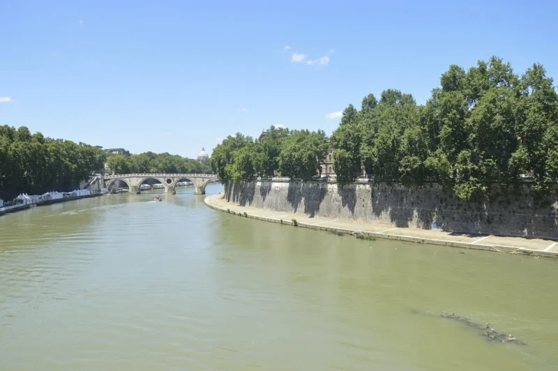
On December 28, 1870, three months after the breach of Porta Pia, the Tiber flooded Rome with a flood that the sources describe as exceptional even for a city used to inundations. The water entered the Pantheon, Piazza Navona, the ghetto, along the whole low band of the center. The government of the Kingdom, just installed, found itself facing the first big technical problem of the new capital, and solved it in the most drastic way possible.
A government commission examined the projects and approved the one by engineer Raffaele Canevari. The law that financed the work, declaring it of public interest, dates from 1875 and was promoted in Parliament with the support of Giuseppe Garibaldi, then a deputy, who had taken a personal interest in the hydraulic regulation of the Tiber. Work began in 1876 and finished, for the urban stretch, in 1926: half a century of construction site.
What the Canevari project called for
The project imposed on the riverbed a constant width of 100 meters between the tops of the walls, along about eight kilometers of urban crossing, with the top of the walls brought more than a meter above the level reached by the 1870 flood. To get that uniform width in a river that in Rome wound between irregular banks, everything standing at the water's edge had to be demolished, on both sides, for the entire length.
The port of Ripetta, the most beautiful piece that vanished
The port of Ripetta was built in 1704 to a design by Alessandro Specchi, on the left bank at the level of today's Via di Ripetta, just below the Mausoleum of Augustus. It was a curved double-ramp staircase that went down to the river, with two hydrometric columns recording flood levels, and it is considered one of the most successful pieces of urban scenography of the late Roman Baroque.
It disappeared between the late 1800s and the early 1900s, overwhelmed first by the embankment works and then by the construction of Ponte Cavour, opened in 1901, which took away even the port's residual function. Practically nothing of the port remains on site: it is known from engravings, drawings and period photographs. The name survives in the street names, that is, in Via di Ripetta and Passeggiata di Ripetta, and that is all.
The port of Ripa Grande, on the other bank
Ripa Grande was the real port, the commercial one, on the right bank under the San Michele complex, facing the Trastevere side. From there came the goods that traveled up the river from Fiumicino and from Ripa: grain, salt, timber, wine. Next to the port Clement XI had the papal arsenal built between 1714 and 1715, on the model of the one at Civitavecchia.
The embankment walls closed the matter: with no landing, river activity ended completely. What remains are two access ramps going down toward the river under San Michele, the building of the former arsenal, and again the street names, Via del Porto and Lungotevere Ripa Grande. Anyone leaning over the parapet at that spot looks at a river that in Rome has had no ports for 130 years.
The houses on the water and the gardens
Along the whole demolished band there were houses that ended in the water, vegetable plots, gardens of noble palaces that went down to the bank, and service structures. The continuous front of 16th-century palaces that faced the Tiber from the side of Via Giulia was cut and closed off by a blind wall, and behind that wall ended up also part of the underground cemetery of the archconfraternity of the Morte, which faced the river and of which only a single room survives today.
The Fountain of Ponte Sisto is the clearest case of a moved object. Built in 1613 against the hospice of the Cento Preti, in rione Regola, at the mouth of Ponte Sisto, it was taken apart around 1880 when the hospice was torn down for the embankment walls. It stayed in pieces for almost 20 years and in 1898 it was reassembled on the other bank, in what is today Piazza Trilussa, to a design by Angelo Vescovali, who managed to recover a little more than half of the original materials.
The demolished ghetto and the Great Synagogue
The ghetto of Rome was established in 1555 and abolished on September 20, 1870, with the taking of the city by the Italian army. At the start of the 1800s about 10,000 people lived there in a very tight area, with a crowding that has no comparison in the rest of the center. The abolition of the restriction did not by itself change the material conditions: the houses stayed the same, overpopulated and unhealthy, for another couple of decades.
The decision that changed everything dates from 1875, and concerns the embankment walls. The route of the new riverside road passed exactly over the ghetto, and the demolition needed just to fit the road in involved tearing down about half of the old quarter. The rest followed with the master plan, and in 1888 a large part of the small streets and surviving buildings was demolished. The sources converge on the year 1888 as the central moment of the operation, with tails in the years immediately after.
What disappeared
Piazza delle Cinque Scole disappeared, one of the main entrances to the quarter, and with it the building that housed the five synagogues united under a single roof, a solution imposed centuries earlier by the ban on building more than one. The network of alleys, courtyards and added floors that had layered up over three centuries disappeared. What remained standing were the Portico of Octavia, the church of San Gregorio della Divina Pietà with its inscription, and a few blocks on the side toward Via del Portico d'Ottavia.
In place of the demolished quarter came the Great Synagogue. The competition was won by Vincenzo Costa and Osvaldo Armanni, work began on July 20, 1901, Vittorio Emanuele III visited the finished building on July 2, 1904, and the official consecration took place on July 27, 1904, officiated by Chief Rabbi Vittorio Castiglioni. The synagogue has a pavilion dome on a square plan, a choice that makes it recognizable from any high point in the city.
Why the synagogue stands exactly there
The position is not casual and is the political point of the whole operation. After three centuries of confinement, the Roman Jewish community built its main building in plain view, on the new riverside road, with a dome visible from afar, and did it on the ground freed by the demolition of the ghetto itself. The page on the Jewish Ghetto of Rome goes into the life of the quarter. Here what interests us is the urban before and after, that is, a closed maze replaced by a monument facing the river.
The other post-Unification cuts
Between 1870 and the early 1900s Rome changed scale. The population grew fast, ministries, barracks and offices arrived, and with them the most violent building speculation in the city's history. The operations of that period do not have the fame of the Fascist sventramenti, but they cut as deep as those and deeper, because they rewrote entire sectors of the center and created neighborhoods from nothing.
Corso Vittorio Emanuele II
The corso was opened to connect the bridge toward the Vatican with Piazza Venezia through the heart of Renaissance Rome, and to do so it went through an extremely dense fabric. The cut grazed or touched a quantity of historic buildings, leaving some palaces with their main facade on a street that didn't exist before and the blind side on truncated alleys. Anyone walking the corso today meets churches that open directly onto the roadway because the churchyard has been eaten by the street.
The new neighborhoods and the markets
Prati was born outside the walls on farmland, with an orthogonal grid deliberately indifferent to the direction of St. Peter's, and is today the neighborhood we talk about on the page on Prati and Borgo. The Esquiline was rebuilt around Piazza Vittorio with arcaded blocks on the Turin model. The slaughterhouse of Testaccio went into operation at the end of the 1800s and brought with it a working-class neighborhood designed around the meat trade.
Mercati Generali on Via Ostiense, opened in the 1920s, moved out of the center the wholesale food trade that until then had taken place inside the walls, at Campo de' Fiori and in the nearby squares. The subject is wider than this page and we cover it in the one dedicated to the markets of Rome. Here the urban fact is enough, that is, that the center lost in a few years a function that had defined it for centuries.
Via dell'Impero: the Alessandrino quarter and the Velia hill
The Alessandrino quarter was born around 1570 at the will of Cardinal Michele Bonelli, nephew of Pius V, from the province of Alessandria, hence the name. Bonelli had the marshy area between Trajan's Column and the Velia reclaimed and raised, reactivating the Cloaca Maxima, and had a regular quarter built over it with a main street, Via Alessandrina, that crossed the buried Forums.
For three and a half centuries that quarter was lived in. Houses of three and four floors, shops, small churches, a couple of convents, all built directly on top of and inside the Imperial Forums, which nobody saw because they lay under six or seven meters of earth and foundations. This is the Rome that disappears: not an abandoned archaeological field, but a living piece of city.
The dates of the work
The first substantial demolitions in the area date from 1924 and 1926, to uncover the Trajan's Markets and the Forums of Augustus and Trajan. In 1929 the executive plans began to be studied. The actual demolitions of the quarter began in September 1931, when the route of the new street had not yet been decided: the master plan called it Via dei Monti and had it reach all the way to San Giovanni.
In the summer of 1932 things sped up to be in time for the celebrations of the tenth anniversary of the March on Rome, with expropriations and demolitions not foreseen in the plan of the year before and an additional expense of 20 million lire. The cutting of the Velia hill, which is the biggest operation of all, removed the only physical obstacle to a straight street and made it possible to make the Colosseum appear at the end of the perspective.
How big the Velia cut was
The documented measurements of the excavation are these: over 200 meters in length, a height between 18 and 25 meters, a width between 40 and 60 meters. A hill was carried away, not a bump. The decision was made after the detailed plan, drawn up eight months earlier, still foresaw a completely different solution, with a square at the level of the Basilica of Maxentius and a connection that overcame the difference in level.
How many people were sent away, and here the numbers diverge
On the number of displaced from Via dell'Impero there are at least three different estimates, all citable, all partial. The Giornale d'Italia of October 18, 1932 spoke of 2,203 rooms demolished, for a total of 608 apartments inhabited by 746 families, but that figure refers only to part of the demolitions and does not include the central block of Via Alessandrina.
Italo Insolera and Francesco Perego tried to calculate the total starting from the data supplied by Antonio Muñoz and from the average crowding density of dwellings in rione Monti, estimated at 1.25 inhabitants per room, arriving at an approximate figure of 7,000 people. This is the estimate that circulates most often in books, and it should be taken for what it is, that is, an indirect calculation.
In the holdings of the Ufficio di Assistenza Sociale kept at the Archivio Storico Capitolino there are two internal sketches, drawn in pencil and with no official value, with more detailed figures. The first puts at 3,140 the dwellings demolished for master plan works between 1929 and 1932 and at 3,389 the evicted families, for a total of 16,915 people, but it includes all the Roman interventions of those years, including those outside the monumental program.
A second sketch, limited to the streets around the Capitoline Hill and the Forums, indicates 874 dwellings demolished, 3,172 rooms, 1,091 families and 4,378 people. This document too was for internal use and the figures should not be taken as definitive, because the inhabitants of some buildings that were also torn down were not counted. They remain nonetheless the most detailed sources we have on the evictions of those years.
Whoever looks for the single number will not find it. The reasonable range for the Forums area alone lies between 4,000 and 7,000 people, depending on what is counted and where the boundary of the intervention is placed. Anyone who cites a flat figure without saying which document it comes from is choosing, not measuring.
Where they ended up
The sketch relating to the sventramenti around the Capitoline Hill is the most explicit document: of 1,309 evicted families, 988 made their own arrangements, 286 went into dwellings of Istituto Case Popolari, 20 into dwellings of the Governatorato and 15 into temporary shelters. In total the families housed with public intervention were 321, that is, less than a quarter. The majority got by on the private market, and almost nothing is known of their moves.
What remains today
Of Via Alessandrina a stump remains. The northern stretch, about 60 meters long, was removed in recent times to reunite the reading of the Forum of Trajan with the other Forums. The archaeological excavation that followed lasted from March 2018 to November 2020 and yielded, among other things, over 60 fragments of the frieze of arms and two heads of the imperial age. The remaining stretch runs at a higher level, above the excavated Forums, and is the only piece of the 17th-century quarter still readable.
The rest can be read in the isolated monuments. The House of the Knights of Rhodes is today a building that floats above the Forum of Augustus because everything around it has been removed. The Torre dei Conti was freed in 1934 from the buildings that enveloped it. The churches of Santi Cosma e Damiano and Santa Francesca Romana face a void that wasn't there before.
The street was inaugurated on October 28, 1932 with a national parade of war-disabled veterans opened by Mussolini on horseback. The name Via dei Fori Imperiali came in 1945, after the regime had fallen. The planned demolitions were never completed because the money for the anniversary ran out, and this explains why even today along the street there survive scraps of modern building that in the plans were meant to disappear.
The Spina di Borgo and Via della Conciliazione
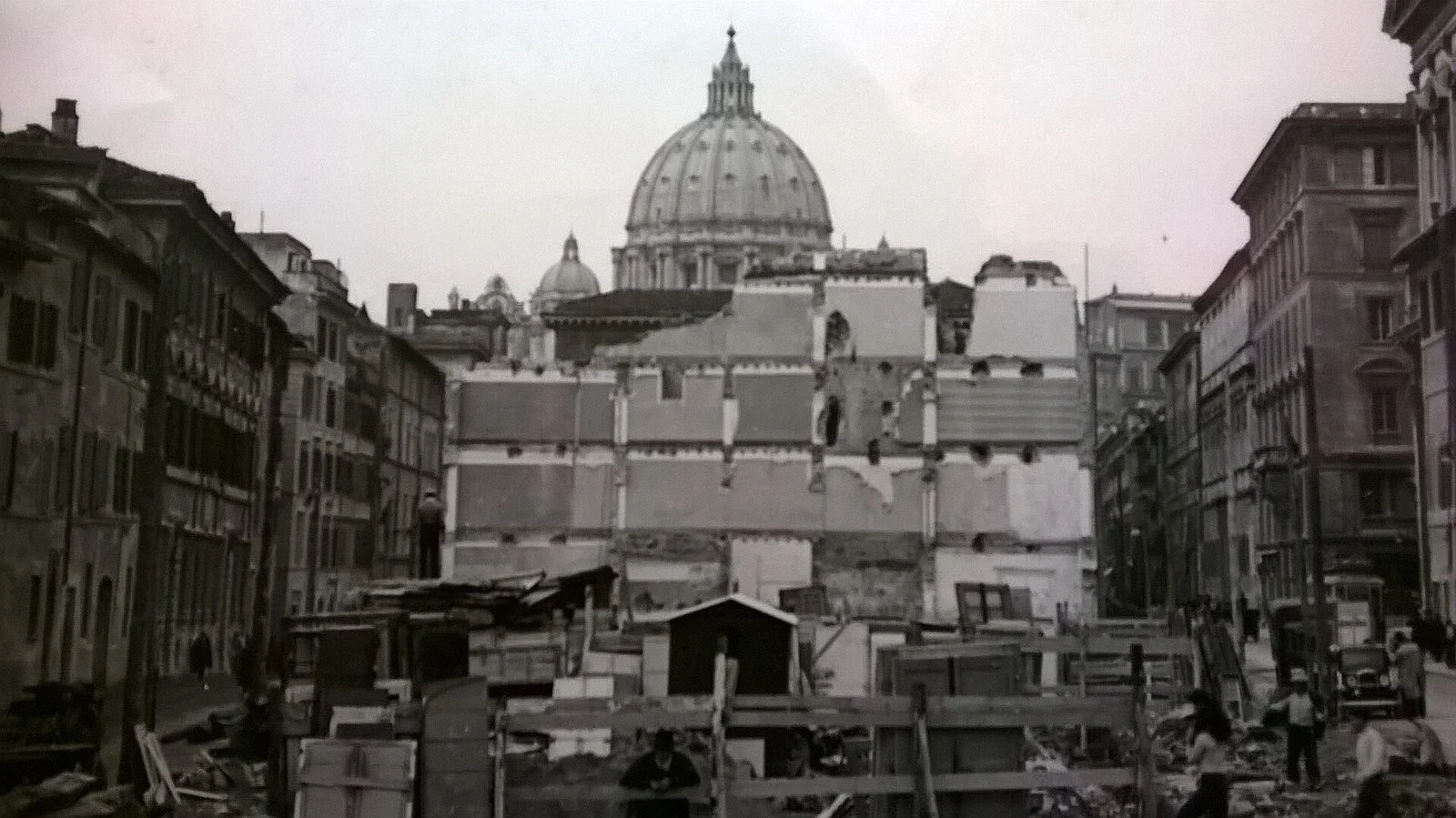
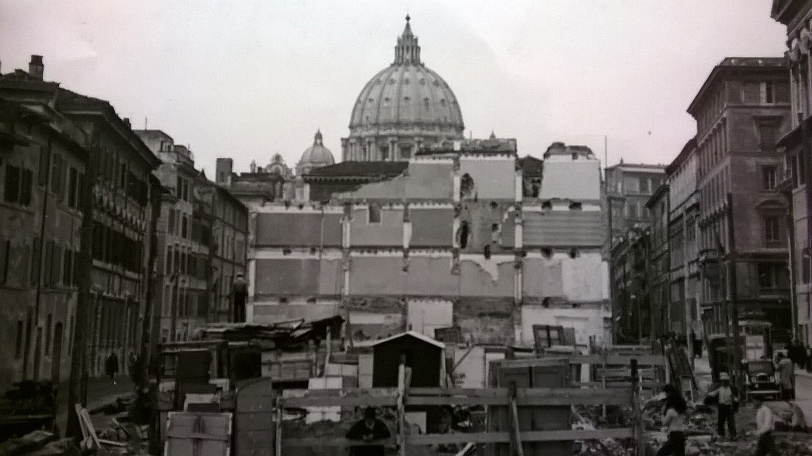
The Spina was a long, narrow, wedge-shaped block, set between two parallel streets: Borgo Vecchio, on the right looking at St. Peter's, and Borgo Nuovo, on the left, opened by Alexander VI around 1500. Between the two streets stood a fabric of houses, palaces and churches, and halfway along opened Piazza Scossacavalli, with its fountain by Carlo Maderno and the church of San Giacomo. The effect was that the basilica appeared suddenly, coming out of the narrow gut of Borgo.
The push to demolish comes from the Lateran Pacts of 1929: a monumental access to St. Peter's was needed that would represent the reconciliation between State and Church. The debate flared up at the end of 1934, with a long series of articles in the Messaggero signed by Antonio Andriulli that record very different positions, even within the regime. Some architects, among them Gai, Natale and Cecchelli, wrote a document opposing the demolition.
Who decided and when
Marcello Piacentini and Attilio Spaccarelli received the official commission in February 1935. On August 14, 1936 Vittorio Emanuele III signed the measure. At the Consulta of Rome, in July 1936, the architect Vincenzo Fasolo raised the most lucid problem of the whole debate, namely that the reasons used to justify the demolition of the Borghi could have justified any other sventramento, leading to the destruction of Rome's building character. Nobody contradicted him: Piacentini and Bottai replied that the work should be considered an exception.
On the start date of the demolitions the sources differ by a day. Part of the historical bibliography gives October 28, 1936, other sources, including the chronicle that describes the scene, give October 29, 1936, with Mussolini in the uniform of commander of the militia who at nine in the morning brings down the first blow of the pickaxe on a cornice of Palazzo Suave, in the presence of Governor Giuseppe Bottai. The difference is minimal and does not change the substance, but it should be pointed out because both dates circulate as certain.
What was demolished
The fabric torn down corresponded, by Vannelli's estimate, to 142 registered properties and about 6,000 cadastral rooms. Other sources speak of about 600,000 cubic meters of built volume. The church of San Giacomo Scossacavalli fell, as did that of San Michele Arcangelo and the college of the Maronites. Palazzo dei Convertendi and Palazzo Rusticucci were taken apart and rebuilt elsewhere, in forms different from the originals.
The Maderno fountain placed in Piazza Scossacavalli was taken apart in 1941 and stayed in storage until 1957, when it was reassembled in front of Sant'Andrea della Valle, a church whose facade Maderno had worked on. Anyone looking at it today sees an object that has changed neighborhood and rione, and that today looks at a different church from the one it was conceived for.
The thing the project did not manage to do
The street was built with parallel sides after the designers realized that the fronts of Borgo Nuovo and Borgo Vecchio followed different alignments relative to the axis of the basilica, one diverging and the other parallel. The initial project included an entrance portico, strongly supported by Piacentini, which in the end was eliminated: it was preferred to have the street open directly onto Piazza Rusticucci, today Piazza Pio XII, bounded by two porticoed propylaea that advance onto the street and narrow its view.
The result is a compromise you can see with the naked eye. The propylaea recreate a kind of interruption: from there you see the facade with the dome, and only by advancing toward Piazza San Pietro does the view open onto Bernini's colonnade. It is the attempt to artificially recover the surprise effect the Spina produced on its own. The basilica lost its backdrop at close range and gained one half a kilometer long.
Via della Conciliazione took its name in August 1937 and was completed in 1950, for the Holy Year. The debate has not closed: Leonardo Benevolo, in a 2004 book, went as far as proposing its removal and the recovery of the spaces of the Borghi, a proposal probably provocative but indicative of how open the question remains. On the quarter that survived around the street we have a dedicated page on rione Borgo.
Who lived in Borgo and where they went
Rione Borgo is the best-documented case of all, thanks to a statistical study edited by Maroi on the eve of the sventramento and published in Capitolium in 1937. In 1931 rione Borgo counted 16,283 people, divided into 3,936 families. The population was for the most part made up of wage-earning workers, 41.08 percent, but it differed from the profile of a classic working-class rione by the presence of merchants, industrialists, clergy and professionals, an effect of the closeness of the Vatican.
Of those 1,236 families, only 188 obtained a dwelling from the Institute: 151 lowest-cost public housing units, 35 public or economy housing units, two among small houses and shelters. The other 1,048 found a place on their own, and of their moves nothing is known at present. Of the 188 assigned, 131 families went to Primavalle, 16 to Tiburtino III and four to Pietralata.
Piazza Augusto Imperatore and the isolation of the Mausoleum
The Mausoleum of Augustus has had more lives than any other Roman monument: fortress of the Colonna, garden, amphitheater for shows and bullfights under the name Anfiteatro Corea, and finally concert hall, the Augusteo, which was for decades Rome's main symphonic hall. Around the mound a dense quarter of Renaissance and 19th-century houses had layered up.
The 1931 master plan and the 1932 detailed plan established that the monument be isolated and a new square created. The project was entrusted to Vittorio Ballio Morpurgo. The demolitions began in 1934 and erased the quarter around the mound. The archaeological excavations had already been carried out between 1926 and 1930 by Giulio Quirino Giglioli and Antonio Maria Colini.
The concert hall that was closed
The Augusteo was a working and well-attended hall, not a ruin. Between 1936 and 1938 the monument was freed of the hall's structures, which was permanently closed. Rome lost its main symphonic hall and went without one for many years. It's the detail that is usually missing from accounts of the operation, because it concerns not public housing but a musical institution, and does not fit the usual rhetoric on the sventramenti.
The square was inaugurated on October 28, 1938, about a month after the opening of the pavilion that housed the Ara Pacis, reassembled for the Augustan bimillennium. The restoration of the Mausoleum, directed by Antonio Muñoz, continued until 1942, when the war interrupted the work. The definitive arrangement of the surrounding area came only between 1950 and 1952.
The two churches left in the middle
The most visible proof of the cut is the two churches on the river side. San Rocco all'Augusteo and San Girolamo dei Croati stood inside a continuous building fabric and today find themselves aligned on a backdrop, with the facade facing an open space conceived 80 years after them. The proportions don't work, and they don't work because those facades were calculated to be seen at an angle, up close, in a narrow street.
Corso del Rinascimento and the demolitions around Piazza Navona
The Corso del Rinascimento was foreseen by the 1931 master plan to replace with a straight street the winding route formed by Via del Pino, Via del Pinnacolo and Via della Sapienza, between Corso Vittorio Emanuele II and Piazza delle Cinque Lune. The project is by Arnaldo Foschini with the collaboration of engineer Salvatore Rebecchini. Mussolini inaugurated the construction site on April 21, 1936, the birthday of Rome, and the street was opened on April 21, 1938.
The operation involved the partial or total demolition of many buildings of value, including Palazzo Cordelli, Palazzo Piccolomini, Palazzo Baldinotti Carpegna and part of the church of San Giacomo degli Spagnoli. Palazzo Madama, seat of the Senate since 1871, found itself with a new front on a wide street. Piazza Navona lost a good part of the fabric that separated it from the rest of the rione.
The judgment of the Romans, back then
The borgate: where the displaced ended up
The official borgate of Rome are 12 and were built between 1930 and 1937 in the Agro Romano, then far from the built-up area, in derogation of the master plan. They are different from the unauthorized borgate, built by the inhabitants on private land, and from the borghetti, spontaneous clusters of shacks that grew on the outskirts, often along the ancient aqueducts. The official ones were planned by the Governatorato of Rome and by Istituto Fascista Autonomo Case Popolari.
The list, clockwise from the west: Primavalle between Via Trionfale and Via di Boccea, Val Melaina and Tufello beyond Montesacro, San Basilio between the Tiburtina and the Nomentana, Pietralata and Tiburtino III along the Tiburtina, Prenestina between Portonaccio and the Prenestina, Quarticciolo between Via Lucera and the Prenestina, Gordiani between Via dei Gordiani and Via Teano, Tor Marancia along today's Via Cristoforo Colombo, Trullo between Magliana and Portuense, Acilia along Via del Mare.
The dates, group by group
During the 1930s Istituto Case Popolari took over management and built new clusters of lowest-cost public housing, of better construction, in some cases next to the existing borgate. In order: Val Melaina between 1930 and 1932, Pietralata between 1935 and 1936, Tiburtino III between 1936 and 1937, Primavalle in 1938, with the borgata inaugurated on May 24, 1938, then Trullo, Tufello and Acilia in 1940, San Basilio in 1940 and Quarticciolo between 1940 and 1942. Acilia was inaugurated on April 21, 1940.
Primavalle and the link with Borgo
Primavalle was born toward the end of 1930 in the northwest quadrant, with a documented purpose: to house about 50 shack-dwelling families who were near Porta Cavalleggeri, where the master plan foresaw a school. The Governatorato bought 25,000 square meters at five lire per meter, nine kilometers from St. Peter's: the very low price of the land is enough on its own to explain the choice of place.
Primavalle is the only borgata that can truly be called the daughter of a sventramento. Of the 188 Borgo families who obtained public housing, 131 ended up there. For all the other borgate the link is much weaker, and on this the archive data contradict the current version.
What the numbers really say
Adding up the assignments relating to the main sventramenti and adding those concerning other interventions in the rioni, such as Via delle Botteghe Oscure, Piazza Nicosia, Trastevere and San Giovanni in Laterano, you count 686 assignments between 1935 and 1940: 410 lowest-cost public housing units, 239 economy and public housing units, 37 among shelters and small houses. These are small numbers compared to the mass of the evicted, and the reason is that most changed home by relying on the private market.
Borgate like Gordiani, Tor Marancia and Prenestina, contrary to the most widespread reconstructions, hosted a very low percentage of people transferred because of demolitions. With the exception of Primavalle, those evicted from the center were not the majority component of the population of the lowest-cost borgate, which filled up through a more fragmentary internal migration: public works in the city outside the walls, shack clearances, transfers decided by the Institute, and also ordinary assignment competitions with drawings by lot.
Documentation is missing precisely where it would be most needed. The files of the Quinta Ripartizione relating to the eviction and housing service, those that would have allowed the families expelled after 1935 to be quantified, turn out to be absent from the archive, at least in the part made available for consultation. It means the total number of displaced by the Roman sventramenti cannot be reconstructed with the sources as they stand.
Why oral memory stays useful even if imprecise
The memory of the borgate tells a linear story: the regime guts Rome, drives out the Romans of the center and confines them far from everything. The archive data say that the direct link holds fully only for Primavalle and that elsewhere the settlement was more complicated, which circumscribes that testimony without dismantling it.
The material condition of the borgate, that is, the isolation, the poor materials, the absence of services, the closeness of the military forts also used as control, is documented exactly as the inhabitants tell it. The page on Quadraro and the one on the places of memory in Rome touch the same ground from another angle.
Where you can still see the cut, walking
The sign of a sventramento is recognized by three clues. The first is the blind wall: a wall without windows, often badly plastered, where the building that leaned against it used to be. The second is the half palace, that is, a building cut with a new, makeshift facade on the side of the cut. The third is the jump in level, where the new street level doesn't match the old one and you see a plinth or a slope.
The exact points to stop at
On Lungotevere dei Tebaldi, at the level of the Fontana del Mascherone, the wall that closes the fountain behind it dates from the late 1800s: the fountain stood in a widening, and now it is squashed against a blind backdrop built for the embankment walls. In Piazza Trilussa, the fountain reassembled in 1898 is the same one that stood on the other side of the river: you look at it knowing it's a transferred object.
On Via della Conciliazione, the memory of Piazza Scossacavalli survives in the name of a very short side street, Via Scossacavalli, which connects Borgo Santo Spirito to the new street. In Piazza Sant'Andrea della Valle, the fountain in front of the church comes from the vanished square. They are two points a kilometer and a half apart, and holding them together in the mind is the only way to understand what happened.
At the Forums, the surviving stretch of Via Alessandrina runs at a higher level above the excavations: you walk on the level of the 17th-century quarter, looking down at the Forums that quarter covered. On the Colosseum side, the brick retaining wall that holds up the remaining slope is the sign of the Velia cut: that wall exists because the hill was carried away.
In Piazza Augusto Imperatore, the two churches on the front toward the river are aligned to a void 80 years younger than they are. In the ghetto, the stretch around the house with the inscription of Lorenzo Manilio, along Via del Portico d'Ottavia, is one of the few surviving scraps: 10 meters farther on the new building begins, and the change is sharp.
A curiosity about Rome before and after
The demolitions of the Spina di Borgo were checked with full-scale models before being completed. In October 1937 temporary life-size structures were erected to check the perspective effect of the street, because the designers had realized that the fronts of Borgo Nuovo and Borgo Vecchio were not parallel to the axis of the basilica and that following them would have produced a crooked street.
Something nobody tells you about Rome before and after
The decorative elements extracted during the demolitions of the Borghi were never reused in the reconstructions. So says a study conducted on the documentary series of the municipal archives, which made it possible to establish which buildings were spared, which were permanently torn down and which were rebuilt in a form unfaithful to the original. Cornices, portals, coats of arms and windows were detached, cataloged, stored, and did not return to the reassembled palaces.
The consequence is that the palaces rebuilt on Via della Conciliazione are copies, not anastylosis. Palazzo dei Convertendi and the palace of the Governor of Borgo look like ancient buildings but their surfaces are remakings, and in some cases the alterations were even done in disregard of the original dimensions. Anyone who photographs them thinking they're photographing the 1500s is photographing the 1940s and 1950s.
My advice for visiting Rome before and after
Take one walk only and do it in chronological order, not geographic. Start from the riverside road at the level of Via Giulia, which is the 1800s, go down to the ghetto and the Portico d'Ottavia, which is 1888, climb back up to Piazza Augusto Imperatore, which is 1934, and finish with the Forums and Borgo, which are 1932 and 1936. In three hours you have crossed 70 years of decisions made by different administrations with different motives.
Choose the wrong hour on purpose. These places read best when they are empty, because the emptiness is exactly the object of the visit. Via dei Fori Imperiali on Sunday morning early, when it is closed to traffic, and Piazza Augusto Imperatore at the end of the day are two moments when the scale of the sventramento is physically perceived, which in traffic doesn't happen. For getting around, the page on how to get around Rome sums up the options.
Another well-known fact, yet rarely mentioned
It's always said that Via dell'Impero was built for parades. True, but the first intended destination was different: the master plan called it Via dei Monti and had it reach all the way to San Giovanni, and at one point there was discussion of building Palazzo del Littorio on it, the headquarters of the party. The idea was then shelved, and with it the last possibility that the street would become something other than a through axis.
The right photo to take in Rome before and after
The photo that tells this page's story is not of a monument but of an edge. Look for the point where the ancient building fabric ends sharply against the new one, and frame the two together, centering neither. On Via del Portico d'Ottavia the passage from the surviving fabric of the ghetto to the late 1800s buildings is a few meters apart and fits in a single frame.
The second useful shot is from above. From the terrace of the Vittoriano, or from the Janiculum for the Borgo side, you see the geometry: the straight line entering the curved fabric, and the way the blocks next to the cut have broken shapes. From above the sventramento reads like a drawing, which from the ground almost never happens.
Some important events that happened here in history
On December 28, 1870 the flood of the Tiber inundated the center of Rome and set off the whole story of the embankment walls. In 1875 Parliament approved the financing law, backed by Garibaldi, which declared the work of public interest. In 1876 work began, which for the urban stretch ended in 1926.
In 1888 a large part of the ghetto was demolished, in implementation of the master plan. On July 20, 1901 construction of the Great Synagogue began, consecrated on July 27, 1904. In September 1931 the demolitions of the Alessandrino quarter began, and on October 28, 1932 Via dell'Impero was inaugurated.
In 1934 the demolitions around the Mausoleum of Augustus began. The Corso del Rinascimento was opened on April 21, 1938. The Spina di Borgo fell between the end of October 1936 and October 8, 1937. Piazza Augusto Imperatore was inaugurated on October 28, 1938 and Via della Conciliazione completed in 1950.
Who has passed through Rome before and after
Raffaele Canevari is the engineer whose project for the embankment walls was approved by the government commission: his work determined the look of the Tiber's banks for eight kilometers and withstood the 1915 flood without damage. Giuseppe Garibaldi, as a deputy, backed the 1875 financing law in Parliament, and had taken a personal interest in the hydraulic regulation of the river.
Corrado Ricci was the first to support the project of freeing the Forums, and Antonio Muñoz physically carried out the operations on Via dell'Impero and the restoration of the Mausoleum. Marcello Piacentini and Attilio Spaccarelli signed Via della Conciliazione. Vittorio Ballio Morpurgo designed Piazza Augusto Imperatore. Arnaldo Foschini, with engineer Salvatore Rebecchini, signed the Corso del Rinascimento. Vincenzo Costa and Osvaldo Armanni won the competition for the Great Synagogue. These are the names that appear on the records, and it's worth keeping them distinct from the politicians who decided.
Vincenzo Fasolo deserves a line of his own. An architect and consultor, in the session of July 1936 he said in public that the reasons given for demolishing the Borghi could have justified the destruction of Rome's building character, and nobody contradicted him on the merits. It is the sharpest critical voice on record from those years, and it comes from inside the institution, not from outside.
Where to find historical photos: archives you can consult, and licenses
Pages like this one are written to work without images, but the images exist and it's worth knowing where they are. Below are only verified archives, with an honest indication of what they offer and on what terms. The general rule in Italy is that a photograph enters the public domain based on the date it was taken and the nature of the work, but that the institution holding it may still ask a fee for supplying the high-resolution file: they are two different levels and it's best not to confuse them.
Wikimedia Commons
Wikimedia Commons is the collection with the clearest terms of use, because every file carries its license written on the page. It contains specific categories on the Roman demolitions, including one dedicated to the Spina di Borgo with photographs of the works. The images are in the public domain or under Creative Commons licenses, and the terms must be read file by file: the category guarantees nothing, the individual page does. It is the first place to look when you need material that is truly reusable.
Archivio Storico Capitolino
The Archivio Storico Capitolino, in Piazza dell'Orologio, holds the archives of the Camera Capitolina, of the papal Comune, of the post-Unification Comune and the Archivio Notarile Generale Urbano. It is the natural place for the administrative documents of the sventramenti, that is, resolutions, expropriations, files of the departments. It also holds a photographic collection of about 3,000 prints on life in Rome between the late 1800s and the mid-1900s, which can be consulted online. The terms for reproduction and reuse must be asked of the institute directly: it is not material published under a free license.
Foto in Comune, Sovrintendenza Capitolina
Foto in Comune is the photographic archive of Musei di Roma Capitale system, with a dedicated portal. It works as an archive and as a point for buying images: you consult it, identify the item and request the supply, which is paid according to a municipal fee schedule. It is not a source of free images, but it is the institutional route to get quality reproductions from the heritage of the civic museums, including Museo di Roma's holdings on the vanished city.
Archivio Storico Istituto Luce
The Luce Archive holds over 3 million images and the film documentation of the newsreels, and for the demolitions of the 1930s it is the richest visual source of all, because those operations were filmed and photographed as propaganda. The Luce holdings of negatives cover the period from 1927 to 1956. The portal can be consulted freely, but use of the images goes through a request for material and a license: they are not images reusable without authorization.
Archivio di Stato di Roma
The Archivio di Stato di Roma offers a photoreproduction service of the documentation it holds, with its own rules on requests and costs. It is the place to ask for state records, while municipal ones are at the Capitolino. Here too reuse is not free by definition and must be checked case by case.
What to expect, in practice
For a web page that has to publish images without complications, Wikimedia Commons is the only source that gives immediate certainty. For research work or a publication with a budget, the institutional archives offer much more in quantity and quality, but with time and costs. The national guidelines on the acquisition and reuse of reproductions of cultural heritage have pushed in recent years toward more open terms, but the application varies from institute to institute and the check must always be made on the individual item.
Eating in the area: Borgo, Forums, Ripetta and Testaccio
The four areas touched by the sventramenti now have four different food situations, and three out of four are difficult. Borgo and the Forums are among the most touristy spots in Europe, Ripetta is an area of offices and shops, Testaccio is the only one where you still eat the way people used to eat. It's worth knowing which of the four you're in before sitting down.
The signs that tell you the place isn't for you
The menu with photographs of the dishes is the first clue. No kitchen that counts on its food needs to show the image of the carbonara: those photos are for people who don't read Italian and say that the expected clientele passes through once. It also goes for the lady rolling out fresh pasta in the window or on the sidewalk, which is a scenic lure and not a sign of cooking, because pasta is made inside, in the morning, without an audience.
The person at the entrance inviting you to sit is the second clue. A place that has to stop people in the street has a filling problem and solves it with recruiting, and in Borgo and around the Forums the figure is almost systematic. The third clue is hours running continuously from morning to night with no kitchen break: a place that serves lunch and dinner stops in the afternoon to clean and prepare, one that stays always open works on a different model.
Prices close the list. In front of monuments, and in particular along Via della Conciliazione and on the front of the Forums, you find places that adjust the bill to the customer: menu items without a price, different price lists between the dining room and the outside tables, cover charges and service that appear only at the end. Asking how much it costs before ordering is not rude, it's the minimum defense.
The repeated signs of the center
In these areas there are chains with the same sign repeated a few hundred meters apart, often right at the points of heaviest foot traffic. They function as a tourist attraction in every respect: they have a recognizable image, lines at the entrance, staff trained to handle volume. There is nothing scandalous and no need to be snobbish, but it should be said clearly that Romans don't go there, and that the product is designed for people who stop once.
The only criterion that always works
Look at who is sitting at the tables and in what language they order. If at 12:30 the room is full of people speaking Italian, who walk in without looking at the posted menu and who greet the people working at the counter, you're in the right place. If instead the room is full at 17:30 and nobody speaks Italian, you're in a place serving another function. It holds in Borgo as at the Forums, and it holds in Testaccio too, where the risk has grown in recent years.
Testaccio remains the area with the best ratio of price to quality among those touched by this page, because it was born as a working quarter around the slaughterhouse and the offal cooking stayed there. The Nuovo Mercato Testaccio in the morning is the place where you understand how it works, and the museo diffuso del rione tells why. For a wider picture, the page on where to eat in Rome reasons by area.
Daniele keeps an updated list on Google Maps with the places he really goes to, with no fees and no commercial agreements: Daniele's list of places. It is a personal selection, not a ranking, and it serves above all to avoid the most predictable mistakes in the most heavily trodden areas.
Frequently asked questions
How many Romans were displaced by the Fascist sventramenti?
A reliable total number does not exist, and anyone who gives one is estimating. The files of the Quinta Ripartizione relating to the eviction and housing service turn out to be absent from the archive for the period after 1935. For the years 1929-1932 an internal sketch of the Governatorato speaks of 3,389 evicted families for a total of 16,915 people, but it includes all the Roman interventions, even those outside the monumental program. For the Forums area alone, estimates range between 4,000 and 7,000 people.
When exactly was the Spina di Borgo demolished?
The demolitions began at the end of October 1936 and ended on October 8, 1937. On the start date the sources differ by a day: part of the historical bibliography gives October 28, other sources give October 29, with Mussolini at nine in the morning bringing down the first blow of the pickaxe on Palazzo Suave. The street took the name Via della Conciliazione in August 1937 and was completed in 1950.
What was there in place of Via dei Fori Imperiali?
There was the Alessandrino quarter, created around 1570 by Cardinal Michele Bonelli on an area reclaimed between Trajan's Column and the Velia hill, and there was the Velia hill, cut over 200 meters in length, between 18 and 25 meters in height and between 40 and 60 in width. Three small churches were demolished, along with the properties of the Pio Istituto Rivaldi with their 16th-century gardens.
Can you see photos of what it was like before anywhere?
Yes, but almost never on site. The main collections are Wikimedia Commons for images with a clear license, the photographic archive of the Archivio Storico Capitolino, Foto in Comune for the heritage of the civic museums and the Archivio Storico Istituto Luce for the footage of the 1930s. Only the first gives immediate certainty on reuse: the others require authorization and generally a payment.
Why is the synagogue of Rome exactly in that spot?
Because that land was freed by the demolition of the ghetto in 1888, imposed by the route of the riverside road decided in 1875. The Jewish community chose to build the Great Synagogue in plain view, on the river, with a pavilion dome visible from afar, after three centuries of confinement in a closed quarter. Work began on July 20, 1901 and the consecration took place on July 27, 1904.
Where did the inhabitants of rione Borgo really end up?
The clearance affected 1,236 families and 4,992 people, about a third of the rione, which in 1931 counted 16,283 inhabitants. Only 188 families obtained a dwelling from Istituto Case Popolari: of these 131 went to Primavalle, 16 to Tiburtino III, four to Pietralata, the others to closer neighborhoods. The remaining 1,048 families found housing on their own and nothing is known of their moves.
Is it true that all the borgate were born from the sventramenti?
No, and the archive data disprove it. Primavalle is the only one that can be called the daughter of a sventramento, because of the influx of the inhabitants of Borgo. Gordiani, Tor Marancia and Prenestina hosted a very low percentage of people transferred because of demolitions. The settlement of the borgate depended on a set of factors: shack clearances, public works outside the walls, transfers decided by the Institute and also drawings by lot in ordinary assignment notices.
Who wrote this page
The page you have read is edited by the editorial team of Tour Leader Pro, a Roman project office that designs visits, itineraries and cultural events in Rome and Lazio. The dates, figures and attributions reported here were compared with academic studies, archive documentation and institutional sources available at the date of publication, and where the sources give different numbers we wrote that instead of choosing one. If you find a figure that doesn't add up, tell us.
Building a route on a subject like this means holding together distant places, different hours and levels of access that change from one block to the next, and above all it means having the right material in hand at the moment you find yourself facing a void. Anyone organizing for themselves or for a group will find planning tools and working materials on Tour Leader Pro, made for those who guide and for those who travel on their own.
For the wider picture, meaning trains, rentals, airports and the destinations in Lazio outside the center of Rome, from the Castelli to the northern lakes to the coast, the reference resource is Italy Planner.