Falerii Novi
In short. Falerii Novi is a Roman city left under a field, with its circuit of walls still standing and a medieval abbey church planted inside.
Falerii Novi is a Roman city left under a field, with its circuit of walls still standing and a medieval abbey church planted inside. It is in the municipality of Fabrica di Roma, in the province of Viterbo, about 50 kilometers from Rome. You enter freely, there is no ticket office, there is no custodian in the open area. The reason to come is one: to walk along an almost complete Roman wall circuit without anyone asking you anything.
The city was founded in 241 BC, after Rome razed Falerii Veteres, the capital of the Faliscans that stood where Civita Castellana is today. The survivors were moved to the plain, to a place easier to control and harder to defend. The result is a regular, almost triangular plan, with Via Amerina crossing it from north to south.
Today inside the walls there are plowed fields, a few rows of vines, a paved road that cuts the site and the abbey of Santa Maria di Falleri. The rest is buried. In 2020 a team from Cambridge and Ghent mapped its entire interior surface with ground-penetrating radar, without touching the soil. That map is the reason the name of this place ended up in newspapers around the world, and also the reason many arrive here expecting something that isn't above ground level.
Where it is and how to get there
The published address for the archaeological area is Via Falerii Novi, 01034 Fabrica di Roma (VT), and there is no street number: the real reference is the provincial road that connects Fabrica di Roma to Civita Castellana, about four or five kilometers from both towns. The sources differ on the exact distance, between the four kilometers given by local tourism and the five declared by the regional portal.
You need a car, and I say it without beating around the bush. The regional railway Roma Piazzale Flaminio, Civita Castellana, Viterbo has a stop at Civita Castellana and one at Fabrica di Roma, but from both stations there remain four or five kilometers of provincial road with no sidewalk and no city bus that reaches the site. On foot it can be done, in a little under an hour, but you walk on the roadway.
The line is owned by the Lazio Region and since July 1, 2022 the infrastructure has been entrusted to ASTRAL while the rail service is run by Cotral. The Rome terminus is at Piazzale Flaminio, below Piazza del Popolo, next to the Flaminio station of metro line A. If you want to try it by train, reckon with the suburban runs, which are far less frequent than those on the urban stretch as far as Montebello.
By car from Rome you exit onto the Cassia bis Veientana and continue toward Nepi and Civita Castellana, or you take the A1 as far as Magliano Sabina and go down toward Orte. An hour and a quarter of driving, barring traffic on the Grande Raccordo Anulare. You park in the dirt pull-offs along the road, in front of the church: there is no equipped parking lot and on open days it can fill up.
A curiosity about Falerii Novi
The circuit of the walls can still be walked almost in full, and that is something you can't do in Rome. The Aurelian Walls you see in stretches, cut by roads, absorbed into buildings, closed behind gates. Here instead the loop closes. You start from a gate, keep the curtain wall on your left and after a little more than two kilometers you are back at the starting point.
On the exact length the sources don't agree. The municipality of Fabrica di Roma gives 2,108 meters, the portal of the Faliscan territory speaks of 2,018 meters, the encyclopedia entry and some museum listings report about 2,400 meters. The difference almost certainly depends on where you measure, on the outer edge of the facing or on the axis of the curtain. In any case we are a little over two kilometers.
There were about 80 towers and about 50 are still standing. They are not whole towers: they are square stumps of tuff that stick out from the curtain at fairly regular intervals, some four or five meters high, others reduced to a tooth of masonry. Counting them as you walk is an exercise that keeps kids busy for the whole loop, and it works better than any explanation.
The walk around the walls, step by step
The full loop takes between an hour and an hour and a half, with stops. The ground is dirt and grass, in some places a path beaten by tractors, in others tall meadow. After rain it turns into heavy tuff mud, the kind that sticks to the soles and doubles the weight of your shoes. Closed shoes, always. Sandals and ballet flats are a terrible idea here.
Porta di Giove
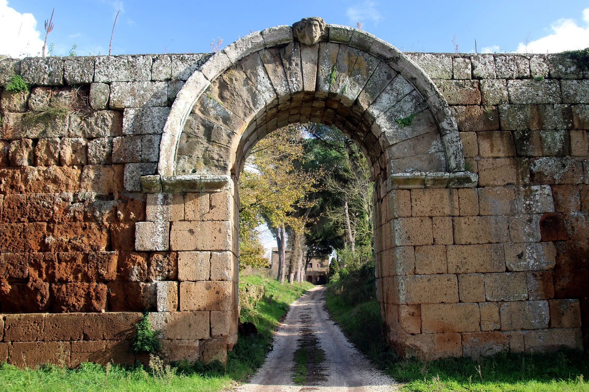
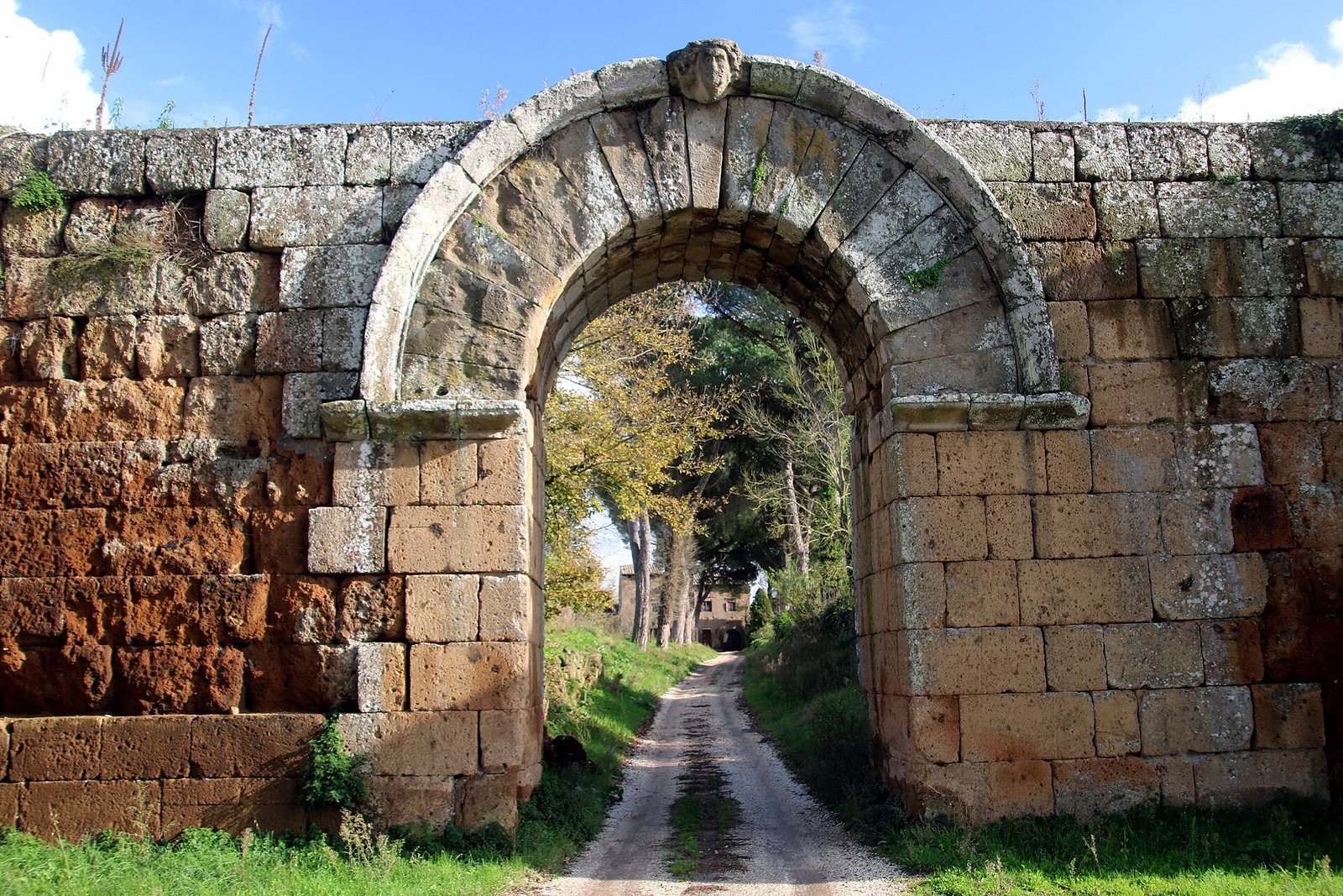
Porta di Giove is the most photographed entrance and the point from which it's best to start. It is a round-headed opening in squared tuff blocks, with a bearded head carved on the keystone. The listing from Faliscan tourism claims that the one visible today is a copy and that the original is in the museum of Civita Castellana: the museum doesn't state this on its own page, so take it as information to confirm on site.
The arch is one of the oldest and best preserved examples of this technique in southern Etruria. Look at the archivolt from the inside, from the countryside side: you can see the joints between the voussoirs without mortar, cut to fit. It is the kind of detail that in a living city you can never observe up close, because traffic goes through it or they built up against it.
Porta del Bove
Porta del Bove opens on the southeast side and is the second that has been well preserved. It owes its name to a carved bovine head, and here too the attribution is local rather than epigraphic. The comparison between the two gates says a lot: same technique, same stone, different conservation outcomes depending on how much vegetation and plowing have worked on the flanks of the curtain.
On the total number of gates the sources diverge sharply. The municipality and the encyclopedia entry speak of eight gates, the regional portal of Lazio counts nine, the Faliscan territory listing six. It is not a scholars' subtlety: it means that the identification of some openings in the curtain is debated, and that a couple of openings may be later or rural passages.
The north side and the amphitheater
Outside the walls, to the north, is the amphitheater. It was excavated in the 19th century and the arena measured 55 meters by 33. Don't expect stands today: what you read on the ground is an elliptical depression and little else, because after the excavation the area went back to being countryside. Anyone who arrives thinking of a small Colosseum goes back disappointed, and the disappointment is avoidable by reading first.
The theater and the forum were also uncovered in the 19th century, inside the walls. Very little of those excavations remains in view. Part of the materials recovered in the urban center and in the surrounding necropolises ended up in the National Etruscan Museum of Villa Giulia in Rome, which for the Faliscan world remains the reference collection together with that of Civita Castellana.
How to read the site on the ground
The difficulty of Falerii Novi is that the main monument is an empty space. Anyone who arrives used to sites where the structures emerge, like Ferento or ancient Sutri, is thrown off. You need to change method: instead of looking for buildings, you look at the perimeter, the ground levels and the direction of the field edge tracks, which often follow ancient axes.
Start from the wall and work inward. From the curtain you grasp the shape of the city, which is a rounded triangle with sides adapted to the slope toward the ditch. From there you sense where Via Amerina ran, because the two main gates face each other on the north-south axis and the modern road roughly repeats its direction.
Then look at the color of the plowed earth. Where there are walls underneath, the worked soil lightens and fills with tuff chips and fragments of brick, while on the free areas it stays dark and compact. It is the same logic the aerial photographs used in archaeology rely on, and with the naked eye it works in the weeks right after plowing.
Last exercise, which always works. Stand under Porta di Giove looking inward and try to estimate how much city you have in front of you: 30.5 hectares, about 43 soccer fields. Then think that all that space was built, lived in for more than a thousand years and then emptied. The silence you hear is the most honest historical fact of the place.
When it is closed and what you don't see
The abbey church is closed for most of the week, and in the cold months some sources indicate opening suspended altogether. The adjoining convent can't be visited: what remains are ruins absorbed into the meadow and partly fenced. Restoration work phases can also close the interior without any notice published online.
Of the Roman theater inside the walls, excavated in the 19th century, very little can be made out on the surface today. The amphitheater outside the walls is a depression in the ground. The baths, the macellum and the temple identified by the radar are not visible in any way. Anyone looking for standing Roman structures, beyond the walls and the gates, won't find them on this site.
The whole set of services an archaeological area open to visitors normally has is also missing: ticket office, visitor center, updated signage, marked routes, restrooms. The flip side is that there is no turnstile, no schedule and no line. For certain visits, and for certain groups, this trade is well worth it.
Something nobody tells you about Falerii Novi
Inside the walls they still farm. It is not a fenced and museum-ized area: it is agricultural land with an archaeological restriction, crossed by a paved road and by field edge tracks. When you arrive in spring you find wheat waist-high over the blocks of the Roman city, and in autumn you find clods turned by the plow. The season completely changes what you see and how much you can walk.
This coexistence of plow and archaeology is the technical reason the site became an international laboratory. Soil that is worked but never built on is the condition geophysical surveys need: no reinforced concrete, no modern utilities, no cellars. Nothing like it exists in Rome, nor at Pompeii, where above the ancient layer there is no countryside but an already open excavation.
The practical consequence for the visitor is that part of the site, in the months of cultivation, is in fact inaccessible without trampling someone else's crop. The wall perimeter always remains walkable along the edge, but cutting inside is not. Respecting the fields here is not generic good manners: it is the condition for the place to stay open and free.
The city under the field: what the radar really showed
In June 2020 the journal Antiquity published the study that made this place famous. The authors are Lieven Verdonck, Alessandro Launaro, Frank Vermeulen and Martin Millett, between the University of Cambridge and Ghent University. The article came out on June 9, 2020 in volume 94, issue 375. Field data collection had begun in 2015. The article can be consulted on the Cambridge Core portal.
The method is less esoteric than it is made out to be. An array of georadar antennas towed by a quad covered all 30.5 hectares inside the walls, collecting about 71.7 million readings and something like 4.5 gigabytes of raw data per hectare. The result is horizontal maps at successive depths, not photographs: they read like plans, with a trained eye.
The structures identified are a bath complex with an open pool, a commercial building interpreted as a macellum, a temple and a public monument near the north gate, made of two twin bodies inside a double portico, which the authors declare without known parallels. A network of water pipes also emerged running under the blocks and not only under the streets, which changes the idea of how the city was designed.
Now the part that is usually cut. Falerii Novi was not a blank sheet: the 19th-century excavations and a magnetometry campaign of the 1990s had already given a partial plan. The same authors write that neither method, georadar or magnetometry, produces a complete picture on its own. Headlines like the city revealed without digging are journalism, not the conclusion of the article.
A second necessary clarification. Falerii Novi is a little under half of Pompeii in extent, so the comparison holds on scale but not on the type of information: the georadar returns plans, not floors, not frescoes, not objects, not stratigraphy. It says where the buried walls are and with what orientation, not in what year they were built or what happened inside.
Since 2021 a real excavation campaign has also been working on the site, the Falerii Novi Project, under concession from the Soprintendenza archeologia belle arti e paesaggio for the province of Viterbo and southern Etruria. Taking part are the British School at Rome with the universities of Harvard, Toronto, London, Florence and Ghent. The project website is faleriinoviproject.org. One of the areas investigated is a monumental Republican temple.
My advice for visiting Falerii Novi
Come on a Saturday or Sunday morning, early, and arrange things first with the municipality's culture office. The archaeological area is always accessible and free, but the abbey church opens only in certain time bands and those bands have changed several times. A phone call to 0761 569001 saves the day. Without that call you risk driving 100 kilometers and finding the door closed.
Bring water. There are no fountains inside the area, no cafe, no public restroom. The nearest services are in the towns, that is in Fabrica di Roma or Civita Castellana. In summer the field has no shade for almost the whole loop, except the tree-lined stretch along the ditch: from 11:00 to 16:00 in July it is a walk to avoid.
Allow a good two and a half hours if you want to do the full loop of the walls plus the church. If you're short on time, at least do the stretch between Porta di Giove and Porta del Bove along the outer side, which is the most continuous and the most legible. Half an hour of walking, and you take home the best thing about the place.
It's worth pairing Falerii Novi with something else on the same day, because on its own it doesn't fill a trip. The combinations that work best are with the very ancient city of Sutri and its amphitheater carved in tuff, or with Calcata and the Treja Valley Park, 20 minutes away by car.
The abbey of Santa Maria di Falleri
The abbey church is the only monumental structure still standing inside the walls, and it is not Roman: it is medieval, built on top of and inside the ruins of the ancient city. It was built by the white monks, and already here the sources quarrel. The documentary tradition gives 1143 as the year of arrival of a monastic colony from Saint Sulpice, with a Cistercian presence attested in 1179.
The municipality and the encyclopedia entry instead place the building at the end of the 12th century and speak of Savoyard monks. Even the founding order is debated, between Benedictines and Cistercians. I won't try to reconcile the divergence: the listing gives it to you as it is, because on this point there is no single version accredited by all the sources consulted.
What you see is very clear. Romanesque facade with a portal in the Cosmatesque manner, three aisles without frescoes and without decoration, and above all the apse solution: one large apse in the center and four smaller ones, two per side. Five apses are a rarity and are the real architectural reason this church deserves the detour, much more than its contested history.
Inside, the columns and several stone elements are reused material taken from the Roman city around it. A specialist listing on the abbeys of Lazio notes among these a marble altar linked to Cornelia Salonina, wife of the emperor Gallienus. Looking at the bases and the column drums you recognize cuts and moldings of different eras lined up without much ceremony, which is exactly how they built in the 12th century.
The complex had an adjoining convent, now largely reduced to ruins. The church remained almost completely abandoned for centuries and restoration restarted around 1990. Anyone expecting a working abbey with a monastic community, like Fossanova or Farfa, won't find it here: it is a monument opened by the municipality, not an active place of worship with regular services.
A local story circulates about the summer solstice, according to which at dawn the light would draw a figure of a dove on the apse, with people showing up at 5:00 in the morning. I report it as a local tradition documented by Tuscia tourism, not as a verified phenomenon: there is no technical source that measures its astronomical orientation.
Another well-known fact, yet rarely cited
Via Amerina passed through here, and it was no ordinary road. It branched off the Cassia, touched Nepi and Falerii Novi and continued toward Ameria, present-day Amelia, in Umbria. In the early Middle Ages its route became the Byzantine corridor that kept Rome connected to Ravenna bypassing the Lombard territories, and this explains why so many settlements along the line survived.
On the ground Via Amerina can still be read well at several points in the Faliscan countryside, with cuts in the tuff several meters high and surviving paving stones. The best stretches run toward Corchiano and in the oasis of Pian Sant'Angelo, where the route runs inside the gorges. Anyone who wants to understand Roman logistics understands it better there than inside the walls of Falerii Novi.
The second urban road was Via Cimina, on the east-west axis, toward the Cimini mountains and Lake Vico. The crossing of the two determines the layout of the city, which is orthogonal but not perfectly regular, because the planners had to take into account the slope toward the ditch and the pre-existing direction of the Faliscan routes.
Hours, access and contacts: the real situation
The archaeological area appears to be always accessible and free of charge, with no ticket office and no published schedule. It is an open space crossed by a road, so in practice you enter at any hour of the day. At night it makes no sense, there is no lighting and the ground is uneven. Data collected from institutional and local sources, checked on September 28, 2026.
On the abbey church the matter is more complicated and the sources diverge sharply. The municipality's tourism page, in a notice dated April 2024, indicated opening from May to October on Saturday from 16:30 to 19:30 and on Sunday from 10:00 to 13:00. A specialist listing instead reports Saturday and Sunday from 9:00 to 13:00, with free admission.
A local news report from 2018 gave Saturday and Sunday from 10:00 to 13:00 with qualified assistance on site. Three sources, three schedules. The fixed point is another: the church is managed by the Municipality of Fabrica di Roma under an agreement with the then Soprintendenza archeologica per l'Etruria meridionale, and opening and maintenance are carried out by municipal staff, not by volunteers and not by a parish.
The reference to call is the culture office of the Municipality of Fabrica di Roma, at Via Alberto Cencelli 20, phone 0761 569001. Guided visits and weekday access have to be arranged with that office. The municipal portal is comune.fabricadiroma.vt.it. An online booking channel is not published: if someone offers you one for a fee, you are buying a service, not a ticket.
Fees for the area and for the church are not published because admission is free in both cases. None of the sources consulted gives a price, and none indicates an included visiting service. Assistance in the church, when there is any, depends on the presence of municipal staff on that shift.
Accessibility
The ground is grassy, uneven and partly sloping, with no paved paths or handrails. Anyone in a wheelchair can drive up to the church, which has access from ground level, while the walk around the walls is out of the question. No accessible restrooms are listed in the area. Ask the culture office which rooms of the complex can be reached, because the answer changes with restoration works.
The right photo to take at Falerii Novi
The photo that works is Porta di Giove shot from outside the walls, from below, with the tuff curtain running off to the right and the field in the foreground. You need raking light: early morning in summer, late afternoon in winter. At noon the tuff turns flat and gray and the arch completely loses the volume of the voussoirs.
The second frame to take home is the row of towers on the long side, shot diagonally with a modest telephoto lens, around 90 or 100 millimeters equivalent. The perspective compression lines up the stumps one behind the other and conveys the idea of how many remain. With a wide-angle the same subject gets lost and looks like any country wall.
Inside the church the challenge is contrast. The five apses can be read only from the central nave stepping back to the inner facade, and without a tripod you need to keep the ISO high and accept some noise. Flash makes everything worse: it flattens the bare masonry, which is exactly what makes that Cistercian interior interesting.
Last tip, counterintuitive. The best photo of the abbey is not the facade but the back, with the apse side poking out of the meadow and the Roman walls in the background. In a single frame you put 13 centuries. It is the only image that really tells what this place is, and almost nobody takes it.
Some important events that happened here in history
241 BC, the deportation
The city is born from a defeat. In 241 BC the Faliscans rebelled against Rome and were crushed in a few days. Falerii Veteres was destroyed and the population moved downhill, to a site with no natural defenses. Founding a city on the plain, under Rome's eyes, was a security measure: a community on the plain can't defend itself and doesn't rebel twice.
The imperial age
Falerii Novi functioned for a long time as a municipal center along Via Amerina, with forum, theater, baths and an amphitheater outside the walls. The bath complex and the commercial building the radar identified indicate a city equipped as you would expect of a mid-sized municipality, with public investment and a water system designed ambitiously from the outset.
The medieval emptying
Around 1033 the population had already returned to the original site, the high and defensible one of Civita Castellana, and the last literary mention of the city would date to 1064. It is the opposite path from that of 241 BC: when the State no longer guarantees security, people go back to the cliff. These dates come from the encyclopedia entry and are not confirmed by an institutional source.
The monastic 12th century
With the city now empty, the white monks settle inside the walls and build the church and the convent. They chose that place for the same reason people had left it: isolation, silence, land to work and already squared stone to reuse. It is a pattern repeated all over Lazio, from Tre Fontane to Fossanova.
19th century, the first excavations
In the 19th century the forum, the theater and the amphitheater were excavated, with the arena of 55 meters by 33. Most of the materials flowed into public collections, in Rome and Civita Castellana. After the excavation the areas were largely covered over and returned to agriculture, which is the reason why today almost nothing of those campaigns can be seen on the surface.
2020, the full map
The publication in Antiquity in June 2020 put Falerii Novi on international front pages. It was the first time the entire surface of a Roman city had been covered with high-resolution georadar. The effect on the ground, it must be said, was almost nil: no new service, no visitor center, no updated sign. The fame arrived in the journals, not on the provincial road.
Who has passed through Falerii Novi
Martin Millett and Alessandro Launaro, of the University of Cambridge, led the work that made the site an international case study, together with Lieven Verdonck and Frank Vermeulen of Ghent University. Millett has worked on Roman urbanism for decades and has stated that the level of detail obtained here could change the way urban sites are investigated.
Since 2021 the excavation site has brought to the place researchers from the British School at Rome together with Harvard, Toronto, London, Florence and Ghent. In June 2024 the results of the campaign were presented publicly inside the abbey, with talks by Stephen Kay for the British School at Rome, Seth Bernard for Toronto and other scholars from the universities involved.
Before them, the site was the territory of 19th-century antiquarians and topographers, the ones who opened the forum and the amphitheater and sent the finds to the state collections. The collections of the Museum of Etruscan and Italic Antiquities at Sapienza and of Villa Giulia hold materials that come from this part of the Faliscan countryside.
As for the monks, they came from far away: the sources speak of a colony from Saint Sulpice and, in another version, of Savoyard monks. They brought with them an architectural model that in Rome and southern Lazio is recognizable at a glance, made of bare walls, measured light and no figurative decoration inside the church.
The position you probably won't like
The georadar, in our judgment, has done more harm than good to visiting Falerii Novi. For five years people have been arriving here with the reconstructions published by the newspapers in their heads and looking on the ground for something that matches. There is nothing to look for: those plans stay two or three meters under the soles of your shoes and will stay there, because nobody intends to dig 30 hectares.
The result is that the real heritage of this place, the almost intact wall circuit of the 3rd century BC, gets treated as a side dish. There are people who drive 50 minutes from Rome, spend 20 minutes in front of the church, look at the field, ask where the baths are and leave. They had just walked along the walls without noticing.
I'll add something that will also displease those who promote the area. Falerii Novi can't carry a whole day on its own, and presenting it as a stand-alone destination creates expectations the place can't meet. It is an excellent first half, with Sutri, Castel Sant'Elia or Civita Castellana to follow. As the absolute protagonist, no.
Eating in the area
You don't eat here. Inside and around the archaeological area there are no businesses, not even a seasonal kiosk, so lunch is organized beforehand: either a packed lunch to eat on the grass outside the walls, or a move to the towns of Fabrica di Roma and Civita Castellana, four or five kilometers each way. Anyone who arrives at one o'clock without a plan goes back to the car hungry.
The warning signs in Tuscia are the same as in Rome, only less frequent. Menus with photographs of the dishes printed large and translated into four languages: a bad sign everywhere. The woman rolling out pasta dough behind the window or directly on the sidewalk is a scenic lure, not a clue to the cooking that comes off the pass. The person who intercepts you at the door and invites you to sit is doing a job of capture, not of hospitality.
Another warning bell: the kitchen open without a break from morning to late at night. A kitchen that never closes is a kitchen that reheats, not one that cooks. And then the question of prices in front of the attractions: in places set right under the photographed monument it happens that some items are not priced, that the fish is sold by the etto with no weight declared, and that the price list posted outside doesn't match the one they bring to your table. Asking for the itemized bill is a right, not a discourtesy.
In the tourist historic centers of Lazio the signs that repeat identically from town to town have multiplied, with the same window and the same portioned product. They work as a tourist attraction, with the line serving as advertising. There is nothing scandalous about it, simply residents almost never go and anyone who wants to understand how people eat in the area has to look elsewhere. No moral judgment, just practical information.
There is only one criterion and it applies from the doorstep: look at who is sitting inside and in what language they order. If at 13:30 on a Wednesday the tables are occupied by locals talking with whoever serves, you are in the right place. If they are all foreigners with backpacks, change street. It holds in Fabrica di Roma as in Viterbo.
The area is a land of pecorino, of chestnuts toward the Cimini, of hazelnuts around Caprarola and Ronciglione, and of white wines of the hills. If you're looking for addresses where to eat, you'll find the updated list on Google Maps. It is a list, not a ranking, and the signs you'll find in there, not here.
What is around, to build your day
Civita Castellana is the natural stop, a few kilometers away: cliff, gorges, cathedral with the Cosmatesque portico and above all the Museo archeologico nazionale dell'Agro Falisco inside Forte Sangallo, on Via del Forte. It is open Tuesday to Sunday from 8:30 to 19:00, last entry at 18:00, closed on Monday, January 1 and December 25. Ticket €5.00 full and €2.00 reduced, phone 0761 513735.
Heading north you find Vasanello, Vignanello and Soriano nel Cimino, and further up the Roman city of Ferento with its theater, which for someone who has just seen an entirely buried site works as a counterpoint: there the structures can be seen, here not.
Toward the Cimini there are Capranica, San Martino al Cimino with its Gothic abbey church, the Palazzo Farnese in Caprarola and the gardens of Villa Lante at Bagnaia. These are long visits, so either Falerii Novi early in the morning or one of these, not both at leisure in the same afternoon.
For those chasing the Etruscans the right area is another one: Tarquinia with the Monterozzi necropolis, Cerveteri with the Banditaccia, Vulci and Tuscania. The Faliscans are a distinct people, they spoke an Italic language related to Latin, and confusing them with the Etruscans is the most common mistake around here.
If the day is hot and the field isn't inviting, half an hour away there are water and shade: the Picchio waterfall near Nepi, the Nepi solfatara for those who can stand the smell of sulfur, and further north Bomarzo, Vitorchiano and Civita di Bagnoregio. Toward the southwest remain Faleria, Blera and Barbarano Romano.
For those returning to Rome wanting to continue the discussion on walls, the two references in the city remain the Museum of the Walls at Porta San Sebastiano, where you walk inside the sentry walkway, and the Aqueducts Park for the theme of water infrastructure, which at Falerii Novi the radar found under the blocks.
Frequently asked questions
Do you pay to enter Falerii Novi?
No. The archaeological area appears to be free entry with no ticket office, and the abbey church too is indicated as free by all the sources consulted. No fee is published by an institutional source. If someone sells an entrance ticket, they are selling an escort service or a transport, not an access pass to the site.
Do you really need a car?
Yes, in practice you do. The nearest station is Fabrica di Roma on the regional railway run by Cotral, but four or five kilometers of provincial road with no public connection to the site remain. Taxis in the area can't be found on the street and must be called in advance. With a bicycle it works well, with small children and strollers it doesn't.
Is the abbey always open?
No, and the published hours diverge between the sources. One version gives Saturday and Sunday from 10:00 to 13:00, another Saturday and Sunday from 9:00 to 13:00, a municipal notice of 2024 reported from May to October Saturday from 16:30 to 19:30 and Sunday from 10:00 to 13:00. Call 0761 569001 before leaving.
How long does the walk around the walls take?
Between an hour and an hour and a half for the full circuit of a little over two kilometers, walking on dirt and grassy ground. With photo stops, reading the panels and visiting the church you easily reach two and a half hours. If you're in a hurry, do only the stretch between the two preserved gates, a little under half an hour.
Can you see anything of what the georadar found?
No, nothing. The baths, the market, the temple and the monument near the north gate are buried structures, identified by instruments and never brought to light. On the surface there are cultivated fields. The maps published in the 2020 scientific article are the only way to see them, and it's best to look at them before you arrive.
Is Falerii Novi Etruscan?
No. It is a Roman foundation of 241 BC, built after the destruction of the Faliscan city of Falerii Veteres. The Faliscans were a people with their own Italic language, close to Latin, settled between the Tiber and the Cimini mountains, in very close contact with the Etruscans but distinct from them. The museum in Civita Castellana explains the difference well.
Are there restrooms, cafes or water points?
No, none of the three inside the area. The nearest services are in the towns of Fabrica di Roma and Civita Castellana. Bring water from home, especially from May to September, when the walk around the walls is almost entirely in the sun. Trash cans are missing too, so you carry your waste back with you.
Can you go with a dog?
In the open area yes, on a leash, bearing in mind that you cross private farmland and that you don't enter cultivated fields. For the inside of the church the rule depends on who opens that day and is not published: ask the municipality's culture office when you phone about the hours, so you avoid arguments on the doorstep.
When is the best time to come?
April, May, October. In spring the field is green and the low light works well on the tuff, in autumn the ground is plowed and you walk better along the perimeter. July and August are tough, with no shade and dry grass. In winter after rain the tuff mud makes the full walk around the walls uncomfortable.
Who wrote this page
The page is edited by the team at Tour Leader Pro, the Rome-based project office that designs and coordinates itineraries, visits and cultural events across Rome and Lazio. Hours, contacts and conditions given here were checked against the sources cited in the text at the date of publication: before getting in the car it's best to recheck them by phone, because in small municipalities they change without notice. Reports of outdated data are welcome.
Whoever puts together a day outside Rome has to make fit together discretionary openings, monuments run by municipal offices and not by tourism bodies, distances that look short on paper and are not on a provincial road, and groups that have to be taken to the restroom and to lunch in places where there is neither. Planning tools for guides and for people who organize on their own are gathered on Tour Leader Pro.
For the big picture on regional trains, car rentals, airports and destinations in Lazio outside the center of Rome, from Tuscia to the lakes to the coast, the resource to consult is Italy Planner, which thinks in terms of whole days and real transfers instead of lists of monuments.