Pian Sant’Angelo di Corchiano (VT) – WWF Oasis
In short. There are places in Lazio that you understand only by entering them on foot, with someone ahead of you who knows the way.
There are places in Lazio that you understand only by entering them on foot, with someone ahead of you who knows the way. Pian Sant'Angelo is one of them. It is not an urban park with a turnstile gate, it is not a scenic rest area along a provincial road, it is not even a fenced archaeological site with a ticket and a bookshop. It is an agricultural property of 262 hectares, between the municipalities of Corchiano and Gallese in the province of Viterbo, which the Lazio Region has declared a Natural Monument and which WWF Italy manages as an Oasis. Inside are cultivated fields, isolated oaks in the middle of the wheat, olive groves, woods that have not been cut for decades and, above all, ravines: those narrow canyons carved in the tuff that make the Agro Falisco a piece of the world different from everything that grows around it.
The first thing to make clear, because it is the reason many people arrive here and stay outside the gate, concerns access. The Oasis is listed as open all year, but only with guided visits and with mandatory booking. Independent access is not permitted. WWF states it on its own listing for the Oasis and the page of the protected area on the regional portal confirms it. Whoever arrives on a Sunday morning convinced of finding a public protected area with a parking lot and a free trail finds instead a country road, an entrance onto a private property and nobody to accompany them. Booking here is not a bureaucratic detail: it is the way the place works.
The second thing to make clear concerns expectations. Whoever is looking for the spectacular ravine, the one 50 meters deep with the waterfall at the bottom and the stream to ford, should know that a few hundred meters as the crow flies away are the Forre di Corchiano, which give that spectacle in a more immediate way and with free access. Pian Sant'Angelo works in a different register: it is a mosaic, a piece of countryside that has kept the structure this whole area had before the great monocultures, with inside it an archaeological heritage, Faliscan and Roman, that elsewhere has been leveled by tractors or swallowed by brambles. The value is not measured on the single glance, it is measured on the quantity of different things that coexist in barely two square kilometers.

Where Pian Sant'Angelo is and how you really get there
The protected area occupies a strip of countryside straddling the boundary between the municipal territories of Corchiano and Gallese, in the province of Viterbo, at an average elevation between 150 and 200 meters above sea level. We are in the heart of what archaeologists call the Ager Faliscus, the Agro Falisco: the portion of northern Lazio lying roughly between the Tiber to the east, the Cimini mountains to the west and the Treja valley to the south, inhabited in pre-Roman times by a people, the Falisci, linguistically related to the Latins but culturally orbiting the Etruscan world.
The entrance to the Oasis opens along the Strada Provinciale San Luca, first stretch, at kilometer 6.500, in the territory of Corchiano. It is an address worth copying in full, because a navigator set to the name of the protected area alone tends to lead to the geometric center of the 262 hectares, which is a wooded ravine without roads, or to the center of the town of Corchiano, which is a few kilometers away.
Whoever leaves from Rome has two roads, and they are not equivalent. The first, indicated by WWF itself, involves taking the Cassia bis heading north, following signs for Nepi, then for Fabrica di Roma and finally for Corchiano. It is the most continuous route, all on medium-traffic roads, and it crosses a piece of Tuscia that is worth the trip even on its own, between Nepi, Fabrica di Roma and their surroundings. The second involves the A1 motorway to the Magliano Sabina exit, then the signs for Civita Castellana, then for Gallese and finally for Corchiano: you gain time on the motorway stretch and lose it in the last piece of provincial roads, so the real advantage depends a lot on the traffic on the Grande Raccordo Anulare at the moment of departure.
Whoever leaves from Viterbo has a simpler route: direction Vignanello, then Fabrica di Roma, and at the second roundabout the signs for Corchiano. The turnoff for the Oasis comes before entering the town, which is worth remembering: whoever gets as far as the square of Corchiano has passed it.
On the train it's best to be honest. The useful station on the Rome-Florence line via Orte is Orte, which is an important rail hub, but from the station to the entrance of the Oasis there are still several kilometers of out-of-town roads with no sidewalk and no public transport service designed for visitors. For a group a bus solves everything. For two people the train is a complication, not a shortcut.
What Pian Sant'Angelo really is: a Natural Monument that is also a farm
Here is the key to understanding everything else. Pian Sant'Angelo was established as a Natural Monument with the Decree of the President of the Lazio Region of February 29, 2000, number 133, published in the Official Bulletin of the Lazio Region of April 10, 2000, number 10. The recognized extent is 262 hectares, the municipalities involved are Corchiano and Gallese, the managing body indicated by the regional portal of protected areas is WWF Italy, which operates through its Foundation. These are the formal data, and they are the ones that explain why the place is visited this way and not another.
The Natural Monument, in the Lazio regional system, is the category of protection designed for specific elements or for limited portions of territory with a particular natural or landscape value. Unlike a regional park, which is born with a dedicated public body, a board, a director and a budget, a Natural Monument can be entrusted for management to a different entity. Here exactly this happened: the land is private, belongs to a family-run farm, and the protection coexists with cultivation.
Inside the perimeter, using organic farming methods, hazelnuts, wine and wheat are produced. There are about 1,200 olive trees and some farmhouses. Over 40 percent of the surface, however, is free of crops and hosts woods and ravines. The order of magnitude that has circulated for years in descriptions of the Oasis speaks of about 160 hectares of agricultural surface and around 100 hectares between deep ravines and broadleaf woods: the two formulations tell the same thing with two slightly different accountings, and the message does not change. Barely two thirds worked countryside, a good third of nature that has taken back its spaces.
This coexistence produces the most interesting element of the whole protected area, the one that a distracted eye doesn't register because it simply looks like countryside: the traditional agrarian landscape preserved intact. Hedgerows at the edges of the fields, large downy oaks left isolated in the middle of the fields, plots of contained size, rows, ditches not covered over. It is the structure that all of central Italy had before the mechanization of the 1960s and 1970s imposed wide fields, felled hedgerows and trees removed because they got in the way of tractor maneuvers. In terms of biodiversity that structure is worth as much as a forest: hedgerows are ecological corridors, isolated oaks are perches and pantries for dozens of species, the margins are the band where most of the life is concentrated.
In recent years the management has added targeted interventions to further increase biodiversity: the creation of a shallow body of water intended above all for amphibians and the planting of new hedgerows at the edges of the fields. They are unobtrusive and very effective operations, the exact opposite of the big enhancement works that fill press releases and empty places.
The tuff ravines and the landscape: what you see inside the 262 hectares
The geology of this corner of Tuscia is the consequence of two events very distant in time that met. The first is volcanic: the Cimino-Vico complex, that is, the apparatus that built the Cimini mountains and the basin that today hosts Lake Vico, covered the surrounding territory for tens of kilometers with eruptive material, depositing layers of tuff of considerable thickness and creating flat terraces. The second is fluvial: once that material had cooled, the watercourses began to cut into it, and the tuff, which is soft vertically and cohesive laterally, lets itself be cut into furrows with almost vertical walls instead of opening into V-shaped valleys as an ordinary rock would.
The result is the ravine: a narrow, deep gorge, with tuff walls that rise sheer and a damp, shady bottom where a stream runs. In Europe a system of ravines as extensive as that of the Agro Falisco is a genuine rarity, and this is the technical reason why the area deserves protection. The hydrographic network of Pian Sant'Angelo belongs for the most part to the basin of the Rio Miccino, a right-bank tributary of the Tiber, and to a lesser extent to that of the Fosso Chiare Fontane, a tributary of the Fosso di Rustica which in turn reaches the Tiber.
Whoever walks here crosses three environments within a few minutes, and the transition is the real spectacle. Up high, on the plateau, there is the cultivated field with its full light, the wheat or the hazel grove, the isolated downy oak that shades a piece of land the size of a room. Then the ground breaks off and the descent begins: the edge of the ravine, where the scrub thickens and the temperature drops by a few degrees within 20 steps. At the bottom you reach the stream, with the shallow water running among the boulders, the walls that take away the sky and a dampness that in July is the most precious thing in the whole province.
Inside the ravines a phenomenon is observed that scholars call inversion of the vegetation succession, and that is the most notable botanical oddity of the place. Normally, going up in elevation, you pass from Mediterranean species to species of cool climates. Here the opposite happens: the species tied to cool climates are found low down, on the bottom of the valleys, where the high humidity and the lack of direct sun recreate microclimatic conditions of a much higher elevation, while up high and on the south-facing slopes holm oak and Mediterranean scrub hold out. The result is that in 40 meters of elevation change you cross two plant worlds that normally lie hundreds of meters of elevation apart.
On the bottom of the valleys grow Turkey oak, manna ash, ash, hazel, wild service tree, true service tree and hornbeam. Along the watercourses the gallery hygrophilous forest forms, with alder, aspen and white poplar closing off the sky above the stream. The undergrowth alternates wild rose, dogwood, hawthorn and privet. On the southern slopes, sunnier, extensions of Mediterranean scrub take over with heather, strawberry tree and phillyrea, while holm oaks and downy oaks colonize the south-facing flanks of the ravines.
There is a management detail worth more than many descriptions: the woods of the Oasis have not been cut for commercial purposes for several decades. Anyone who knows the woods of central Italy knows how rare this is. Nearly all the wooded surfaces of Lazio are coppice, that is, woodland cut in rotation every 15 or 25 years, made of thin shoots all of the same age. Here instead the stand is evolving toward high forest, uneven-aged, with trees of different ages, climbing plants and, above all, dead and rotting wood standing and on the ground. Dead wood is the element missing almost everywhere and that makes the difference for wood-boring insects, woodpeckers, bats and the whole chain that depends on them. A clean forest is a poor forest, and this is one of the few truths of forest ecology that admits no nuance.
A curiosity about Pian Sant'Angelo di Corchiano (VT) - WWF Oasis
The curiosity concerns a bridge that carries neither people nor carts: it carries water. Inside the perimeter of the protected area a construction is preserved known locally as Ponte del Ponte, which is an aqueduct work built in tuff ashlar masonry to span the Fosso di Pian Sant'Angelo. The dating given by the sources of the protected area places it between the third and fourth centuries BC.
It's worth pausing a moment on what this means. We are talking about a monumental hydraulic work built in an era when Rome, 50 kilometers away, had just begun to equip itself with its own aqueducts: the Aqua Appia dates to 312 BC. Here, in a territory that school textbooks dismiss in two lines as the periphery of southern Etruria, there existed a community capable of designing a masonry crossing to carry water from one side of a ravine to the other, cutting and squaring blocks of tuff and assembling them dry with the precision that ashlar masonry requires.
Ashlar masonry (opera quadrata), for those not familiar with the term, is the building technique that uses squared parallelepiped blocks, laid in regular courses, without mortar. It holds thanks to the weight and the precision of the cut. In a material like tuff, soft to work but fragile under impact, it requires nearby quarries, specialized workers and a site organization that presupposes a strong patron. The presence of a structure of this kind in the middle of the fields tells much more than any museum display case about the technical capacity of the Falisci and their neighbors.
The second face of the curiosity is that the bridge survived precisely because the place never became anything. No city expanded over it, no modern road cut through it, no quarry eroded it. It stayed there, at the back of an agricultural property, protected by the economic irrelevance of the place, until the moment when economic irrelevance became a value to defend. Many of the things preserved in Italy are preserved for this reason, and rarely does anyone say it out loud.
The archaeology of the Oasis: via Amerina, rock-cut tombs and the world of the Falisci
The Natural Monument protects a portion of the ancient Ager Faliscus, and the definition is not rhetoric. In the first millennium BC the demographic expansion of the main Faliscan centers, starting with Falerii Veteres, today's Civita Castellana, led to the birth of many secondary rural centers. Among these, in the eighth century BC, Corchiano and Vignanello arose. The territory now included in the Oasis was therefore in the middle of a densely inhabited, cultivated countryside, crossed by roads and dotted with necropolises dug into the tuff walls.
The most important infrastructural element is via Amerina, built in the fourth century BC as a connecting axis between Nepi and Veii, with a course parallel to that of the Cassia. Locally it is paved with leucite basalt blocks, a dark and very hard volcanic rock, and within the protected area stretches of the paving are preserved. Walking on a road of the fourth century BC is not a frequent experience in Italy: normally the ancient consular roads lie under the modern state roads, which followed their route precisely because it was the right route. Here instead via Amerina lost importance early enough to stay where it was, and this makes it readable.
The later history of via Amerina deserves a line, because it explains the medieval fortune of this whole belt of territory. After the fall of the Western Empire and during the long war between Byzantines and Lombards, the corridor that linked Rome to Ravenna through the Agro Falisco and southern Umbria remained for decades the only safe road in Byzantine hands. That corridor, in large part, coincided precisely with via Amerina. The necropolises, the parish churches and the perched villages found between Corchiano, Gallese, Orte and the Tiber valley tell the same story from different vantage points.
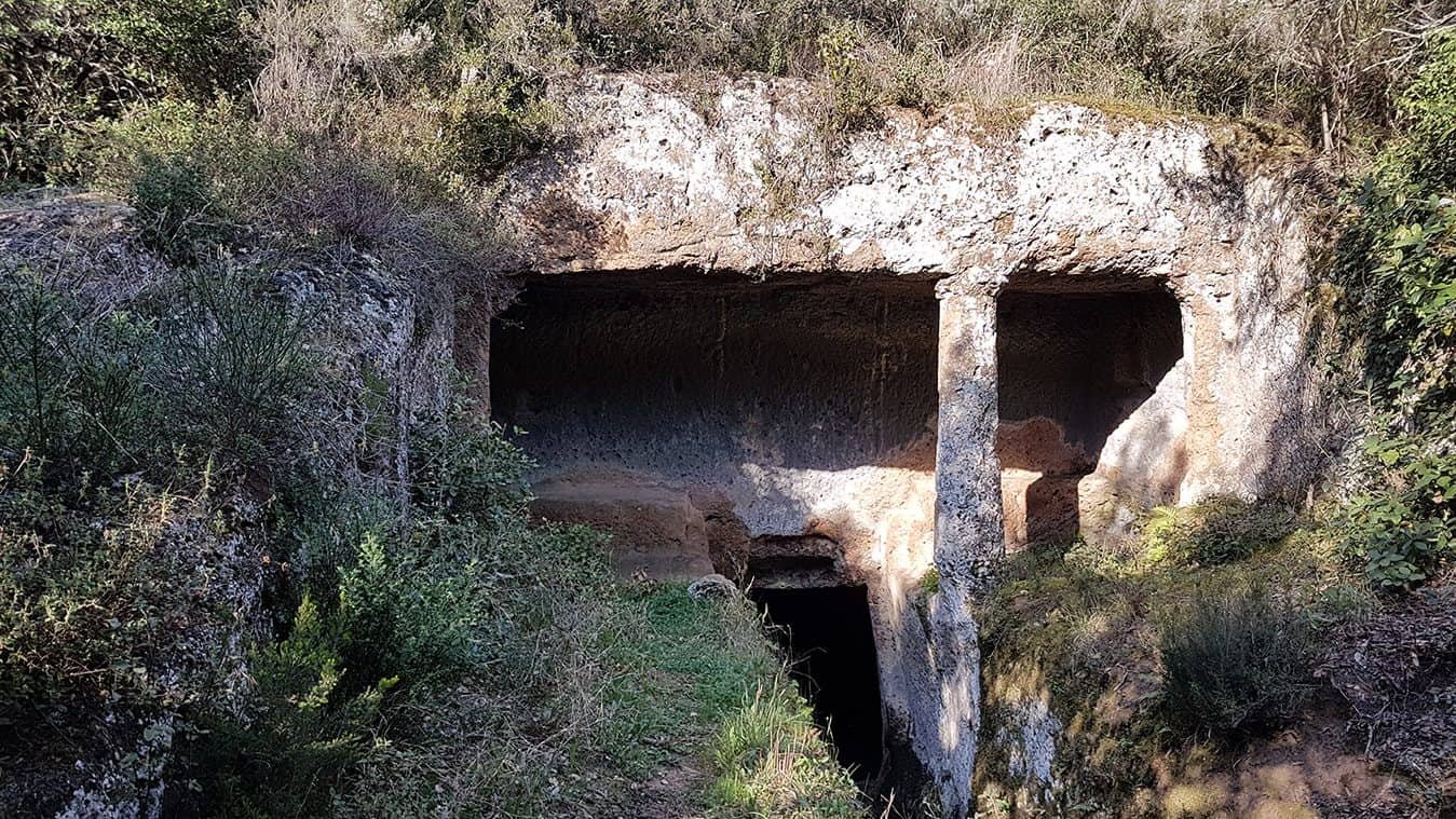
Among the funerary testimonies preserved inside the protected area, two rock-cut chamber tombs of considerable architectural quality, of the Etruscan-Faliscan age, stand out. The first is the so-called Tomba del Capo, datable between the third and second centuries BC: a portico tomb with a burial chamber below, which still preserves the carved trace of the false door, the columen on the ceiling, that is, the false beam carved in the tuff in imitation of wooden domestic architecture, and a column in the facade. It is architecture dug out rather than built, and it reproduces in the rock the elements of a house: the door that doesn't open, the beam that supports nothing, the column that holds up no architrave. The world of the dead as a dug-out copy of the world of the living.
The second is the Tomba del Pipistrello, brought to light only in 2015 and attributable to the same period. The fact that a chamber tomb of this kind emerged so recently, inside an area already protected and already studied, says how much still remains under the vegetation of the ravines across the whole Agro Falisco. Anyone who knows the area knows that every winter, when the rains move the earth on the slopes, something turns up.
Human presence in this portion of territory goes back, however, to a much more remote era. Ravines and rock shelters were frequented as far back as the Paleolithic, as many finds from excavations carried out in the first decades of the 20th century attest. The reason is evident as soon as you descend into a ravine: permanent water, shelter from the wind, walls soft to dig, and above, on the plateau, game and later land to cultivate. No human being with a minimum of common sense would have ignored a place like this.
With the Roman conquest the picture changes. After the defeat of the Falisci in 241 BC, Falerii Veteres was abandoned and the population moved to the new Falerii Novi, in the plain, easier to control. Many settlements of the Faliscan territory, Corchiano included, were abandoned in the same framework. It is one of the rare occasions on which the end of a settlement landscape can be dated precisely, and its effects on the territory of the present Oasis are still readable: tombs and roads remain, the settlements do not.

Something nobody tells you about Pian Sant'Angelo di Corchiano (VT) - WWF Oasis
The thing almost nobody says is that the highest natural value of these 262 hectares is not found in the ravines, which are the photogenic part, but in the fields. It is a statement that sounds counterintuitive and that in fact holds up very well against the facts.
The ravines of the Agro Falisco, after all, defended themselves. They are steep, shady, hard to reach and impossible to cultivate: nobody touched them because it wasn't worth anybody's while to touch them. Nature stayed there by inertia, not by merit. The fields instead are the exact opposite: they are the profitable part, the one on which every management choice has an immediate cost. Leaving an isolated downy oak standing in the middle of an arable field means losing productive surface, going around it with the machine, harvesting less. Keeping a hedgerow instead of tearing it down means giving up a strip of land and accepting the competition of the roots. Growing hazelnuts, wine and wheat organically, in a territory where the hazel has for decades been synonymous with intensive treatments, means lower yields and greater risks.
The traditional agrarian landscape you see here is not a random remnant: it is an economic choice repeated every year, by a family farm, for decades. And the ecological result is enormous, because the species that are disappearing in Italy are not those of the deep woods, which in many cases are even increasing, but those of traditional agricultural environments: the birdlife of the croplands, the amphibians of the temporary pools, the pollinating insects of the grassy margins, the small mammals of the hedgerows. The fact that as many as 93 bird species are recorded at Pian Sant'Angelo, of which at least 72 nesting and 35 of conservation interest, does not depend on the ravine. It depends on the mosaic.
The second part of the argument is less flattering and just as true: a model of this kind is fragile. It holds as long as a family decides to make it hold. A generational change, a bad year, a reform of agricultural subsidies that penalizes small farms, and the mosaic simplifies within two seasons. Hedgerows are removed in a week. Rebuilding them takes 20 years. Whoever books a visit here is not buying just a walk: they are contributing in a small way to making sustainable a way of keeping the land that the market, by itself, does not reward.
Third and last observation. The formula of the Natural Monument entrusted to a private entity for management has another practical effect little told: there is no public office with hours and a counter to turn to. Operational information goes through the telephone, the mailbox and the social page of the Oasis. Whoever expects an institutional website refreshed every day, with a real-time visit calendar and automatic booking, is disappointed. Whoever instead phones and talks to a person usually gets precise answers and the possibility of building the visit to measure, which is exactly the opposite of what an online ticket office offers.
The advice I give you for visiting Pian Sant'Angelo di Corchiano (VT) - WWF Oasis
The main advice is only one and has to be said first: phone beforehand, and phone with real advance notice. The Oasis number is 345 7576224 and the mailbox is piansantangelo@wwf.it. Guided visits require mandatory booking and independent access is not permitted. School classes and groups, with a stated minimum of 15 people, can enter every day by booking. For photographers and birdwatchers it is possible to arrange access at particular hours, with specific arrangements to be defined directly with the management. This last possibility is precious and little used: whoever photographs knows that the two hours around dawn are worth more than the whole day, and here a channel exists to obtain them instead of having to give them up.
The second piece of advice concerns how you frame the request. A call that says only "I'd like to visit the Oasis" gets the standard proposal. A call that says what you are really interested in gets much more. If the interest is archaeological, it's worth saying so right away and asking explicitly whether the route planned that day touches the Ponte del Ponte, the paved stretches of via Amerina and the rock-cut tombs. If the interest is botanical and the period is that of the blooms, it's worth saying so: the wild orchids are noted as an element of importance, but they are pinpoint, last a few weeks and whoever knows them knows where to look. If the interest is ornithological, it's worth saying so and asking for the right hours. The guide who accompanies you knows where things are. The visitor who doesn't declare what they're looking for inevitably gets the generic tour.
Third piece of advice, on shoes and clothing. The route recorded in the regional trail network as CAI 136A, which bears the name of Pian Sant'Angelo, measures 4.1 kilometers with difficulty classified E, that is, hiking, with about 20 meters of elevation gain and about 10 of descent. Numbers that look harmless and need to be read in context: the total elevation change is minimal because you walk mostly on the plateau, but the ground on farmland and at the edges of the ravines is uneven, with furrows, clods and muddy stretches after rain. Trekking shoes with a lugged sole, not city sneakers. Long pants, always: the margins of the fields are full of brambles and, in the warm season, of ticks. A careful check on return is part of the game when you walk in agricultural and wooded environments of central Italy, and nobody ever tells you.
Fourth piece of advice, on water and food. There are no kiosks, vending machines or bars here. Bring a full water bottle from home, and in summer bring more than one. Lunch, if the visit takes half a day, is solved on the return in Corchiano or in the nearby towns, where the cooking of southern Tuscia works on solid foundations: the local oil, the hazelnuts of the Agro Falisco that have a serious market, the wines of the Cimini. An obvious recommendation that is worth repeating: whatever you bring in leaves with whoever brought it. On an organic farm every abandoned piece of waste is a concrete problem, not an aesthetic matter.
Fifth piece of advice, the one about mental time. Pian Sant'Angelo should be visited slowly. Whoever arrives with the idea of ticking a box and moving on to the next site doesn't understand where they are, because the richness is distributed and not concentrated: it lies in the 10 meters of hedgerow where six different species move, in the downy oak with the hollow trunk, in the stream where the freshwater crayfish survives because the water is still clean, in the tuff wall where you glimpse the cut of a burial chamber. Two hours walked slowly are worth more than four walked fast.
Fauna and flora: who lives inside the 262 hectares
The faunal list of Pian Sant'Angelo is the kind that makes eyebrows rise for anyone who knows the situation of wildlife in central Italy, because it contains almost all the species that once frequented our countryside and that elsewhere have disappeared as a result of land transformation, pollution of waters and soils, the use of pesticides and growing urbanization.
Among the mammals, present either directly or through their traces, are the porcupine, the badger, the weasel, the wild boar, the pine marten, the polecat, the fox and the elusive wildcat. The latter deserves a parenthesis: the European wildcat is a species that almost nobody ever sees, nocturnal, wary, hard to tell at a distance from a tabby domestic cat, and its stable presence is considered an indicator of forest continuity and low disturbance. In the same list appear the edible dormouse and the hare, the latter easily observed in the cultivated fields.
Among the reptiles are recorded the common tortoise, that is, Hermann's tortoise, and the four-lined snake, the largest snake in Italy and one of the most harmless, traditionally tolerated by farmers because it eats rodents. Among the amphibians appear the tree frog and the common toad, and it is precisely for them that the shallow body of water mentioned before was created: amphibians are the group that has suffered most from the disappearance of pools, watering troughs and ditches not turned to concrete.
In the watercourses lives the freshwater crayfish, and this is perhaps the most significant piece of information in the whole list. It is a species extremely sensitive to pollution, which disappears at the first discharge and the first runoff of agrochemicals from the fields upstream. Its presence certifies that the water running at the bottom of the ravines is still truly clear, and directly links the choice of organic farming on the plateau to the life observed 40 meters lower down. The freshwater crayfish is, in practice, the test of the entire management model.
The birdlife is the richest chapter. 93 species recorded, at least 72 nesting, 35 of conservation interest. Among the nocturnal raptors are the long-eared owl, the barn owl, the tawny owl, the little owl and the scops owl, that is, practically the entire company of the owls of central Italy, which presupposes available cavities, farmhouses with accessible attics and old trees. Among the diurnal ones appear the buzzard and the kestrel, the peregrine falcon, the honey buzzard and the sparrowhawk. The peregrine needs vertical walls to nest and the tuff ravines provide them, the honey buzzard is a migrant specialized in the nests of hymenopterans, the sparrowhawk hunts inside the woods with maneuvers that seem impossible. In the fields you see pheasants, quails and all the passerines typical of traditional agricultural environments, which is also the category of birds in greatest decline across Europe.
On the plant side, besides the formations already described, the blooms deserve a mention. Cyclamens and anemones in the undergrowth, rockroses on the warm slopes and above all wild orchids, noted as an element of particular importance. Among the genera documented in the area are names that tell an enthusiast a great deal: Dactylorhiza romana, Orchis purpurea, Serapias lingua, Spiranthes spiralis. The last flowers in autumn, when the season is already closed, in tiny, twisted spikes that go unnoticed by anyone who is not looking for them. Wild orchids are not picked, not transplanted and not trampled: they are protected, they depend on symbiotic soil fungi and a plant pulled up does not grow back elsewhere.
Another well-known fact, yet rarely mentioned
The well-known fact is that the Agro Falisco has the most extensive system of ravines in Europe. You read it everywhere, the guides repeat it, it appears in the educational materials. What is almost never added is the practical consequence of that record, which is administrative in nature more than geological: that unique system has no single body protecting it, and it is fragmented into a mosaic of different protections that touch and don't talk to each other.
You only have to look at the map. The ravines of the Rio Fratta at Corchiano are a natural monument on their own. Pian Sant'Angelo is another natural monument, managed by WWF. The Valle del Treja Park is a regional park with its own body, its own director and its own plan. The Nazzano Tevere Farfa Nature Reserve guards the confluence on the Tiber side. Farther west the Lake Vico Nature Reserve covers the volcanic origin of the system. The Park of the Ancient City of Sutri protects another piece of the same story of tuff and cuttings. All these areas tell the same geological phenomenon and the same civilization, and each has its own rules, hours, budget and communication.
The result is that the visitor never finds a single front door. There is no integrated ticket, no coordinated signage, no overall map of the ravines of the Agro Falisco hung in every municipality. Whoever wants to understand the system has to build it alone, visit after visit, and almost always does so by chance, arriving at Pian Sant'Angelo for the nature and discovering the archaeology, or arriving at the ravines for the archaeology and discovering the botany.
There is a second aspect little cited, and it concerns tourism. This area lies less than an hour and a half from Rome, in a region that receives tens of millions of visitors a year, and it remains essentially unknown. The reason is not the distance, which is ridiculous, and it is not the quality, which is high. It is the absence of a synthetic image. Tuscany has its cypresses, Umbria has Assisi, the coast has the sea. The Agro Falisco has a landscape that has to be explained before it can be appreciated, because the ravine isn't seen until you lean over it: from the car window it looks like ordinary countryside, and the cut in the tuff opens only when you are already above it. A territory that doesn't show up on a postcard struggles to become a destination, and this is at once its commercial curse and its environmental fortune.
The right photo to take at Pian Sant'Angelo di Corchiano (VT) - WWF Oasis
The photograph that tells this place best of all is the one that puts in the same frame the two things that coexist here and that elsewhere are separate: the cultivated field up high and the dark cut of the ravine that opens right below. It is a photo that requires finding the right point on the edge of the plateau and waiting for raking light, because at midday the contrast between the lit field and the ravine in shadow is impossible to hold together in a single shot. The first hour after dawn and the last before sunset solve the problem: the low light comes in from the side, lights the tuff wall instead of leaving it black and draws out the texture of the field.
The second photograph, simpler and more effective than it seems, is the portrait of an isolated downy oak in the middle of the arable field. It is the visual symbol of the traditional agrarian landscape and works in every season: with the green wheat in spring, with the golden stubble of July, with the dark plowed earth in autumn, with the low fog on January mornings. It's best to crouch down, keep the horizon low and let the tree occupy the sky, because the real subject is the isolation.
A practical note on conduct: nature photography inside a managed protected area has precise rules, and here there is the possibility of arranging access at particular hours precisely for photographers and birdwatchers, with specific arrangements set by the management. Whoever needs the dawn light asks for that channel when booking. No sound lures to attract birds, no deviation from the route to approach a nest, no drone without explicit authorization. These are obvious rules and in fact they are regularly violated.
Some important events that happened here in history
The chronology of this piece of territory reads like a summary of the history of central Italy, and it's worth going through it in stages.
The first stage is prehistoric. The ravines and rock shelters of the area were frequented as far back as the Paleolithic, and many finds from excavations carried out in the first decades of the 20th century attest to it. It is not a stable settlement in the modern sense, but the recurring presence of human groups who found in these furrows water, shelter and raw material.
The second stage is the eighth century BC. The demographic expansion of the main Faliscan centers, starting with Falerii Veteres, leads to the birth of many secondary rural centers, among them Corchiano and Vignanello. The countryside that is now the Oasis enters its phase of greatest pre-Roman agricultural organization: worked land, roads, necropolises dug into the tuff walls, places of worship.
The third stage is the fourth century BC, with the building of via Amerina, a connecting axis between Nepi and Veii, running parallel to the Cassia and with local paving in leucite blocks. It is the moment when this territory passes from being a well-populated countryside to being a transit corridor, with everything that follows in terms of trade, wealth and, inevitably, military exposure. To the same phase, between the fourth and third centuries BC, date the monumental hydraulic works like the Ponte del Ponte.
The fourth stage is the Roman conquest. In 241 BC the defeat of the Falisci ends the autonomy of this people: Falerii Veteres is abandoned and many settlements of the Faliscan territory, Corchiano included, share the same fate. Chamber tombs continue to be dug for a few more generations, between the third and second centuries BC, as the Tomba del Capo and the Tomba del Pipistrello show, but the center of gravity moves elsewhere, to the plain and along the axes controlled by Rome.
The fifth stage is early medieval. In the long war between Byzantines and Lombards the corridor that linked Rome to the Exarchate of Ravenna crossed this very belt of territory, following in large part via Amerina. For decades it was the only safe link between the two capitals, and its strategic importance explains the dense network of castles, parish churches and fortified villages that still today dots the area between Corchiano, Gallese, Orte and Civita Castellana.
The sixth stage is modern and concerns agriculture. The 20th century brings to southern Tuscia mechanization, the merging of holdings, the felling of hedgerows and, from the 1960s on, the expansion of the specialized hazel grove, which in the province of Viterbo has reached enormous dimensions. The previous agrarian landscape disappears almost everywhere. The Pian Sant'Angelo property follows a different road and preserves the traditional structure: it is this choice, repeated for decades, that makes possible everything that comes after.
The seventh stage is February 29, 2000, with Decree of the President of the Lazio Region number 133, published in the Official Bulletin of the Lazio Region of April 10, 2000 number 10, which establishes the Pian Sant'Angelo Natural Monument on 262 hectares in the municipalities of Corchiano and Gallese. Management is entrusted to WWF Italy, which operates through its Foundation, and the area becomes part of the regional system of protected areas of Lazio.
The eighth stage is very recent: 2015, the year in which the Tomba del Pipistrello was brought to light. An archaeological discovery inside a protected area established 15 years earlier is the clearest way of saying that this territory has not yet finished telling its story.
Who has passed through Pian Sant'Angelo di Corchiano (VT) - WWF Oasis
The people who have crossed this countryside left no signatures on the walls, but they left traces more solid than a signature.
The hunters and gatherers of the Paleolithic passed through, those whom the finds of the 20th-century excavations document in the shelters of the ravines. The Falisci passed through, who built their countryside here: they dug the burial chambers in the tuff imitating their houses, laid out the roads, raised the aqueduct over the stream. The Romans passed through, who paved via Amerina with leucite blocks and then emptied the Faliscan centers after 241 BC.
In the early medieval centuries there passed through the messengers, soldiers and pilgrims who traveled the corridor between Rome and Ravenna, in an era when choosing the wrong road meant ending up in enemy territory. The monks and builders of the parish churches that still mark the surrounding countryside passed through, and the farmers who for about 20 generations cultivated the same fields with the same tools, opening and maintaining the landscape that is now protected by law.
The archaeologists and paleontologists of the first decades of the 20th century passed through, those whose excavations in the ravines produced the finds that still today date the oldest presence in the area. More recently passed through the scholars who in 2015 identified and brought to light the Tomba del Pipistrello, giving back a monument that nobody expected anymore.
The WWF volunteers and staff passed through, who since 2000 have managed the area on behalf of the association and who built the program of guided visits, the activities with schools and the interventions to increase biodiversity, among them the body of water for the amphibians and the new hedgerow plantings. The members of the Club Alpino Italiano passed through, who surveyed and entered into the regional trail network the numbered route 136A, whose 4.1-kilometer course now appears on the official cartography of the protected areas of Lazio.
And passing through, every year, is a family that continues to grow hazelnuts, wine and wheat organically inside a protected area, to maintain 1,200 olive trees and to decide not to cut down the isolated oaks in the middle of the fields. Without that daily passage, silent and without commemorative plaques, there would be nothing to visit.

When to go and when it's better to postpone
Spring is the best season, no argument. Between March and May the ravine woodland is at peak activity, the blooms of the undergrowth follow one another, the wild orchids appear, the nesting birds sing and the wheat on the plateau is green. The temperatures allow comfortable walking and the ground, except after days of rain, holds up well.
Autumn is the second choice and in some ways the most underrated. October and November bring the colors of the broadleaf trees in the ravines, the clean air that makes the tuff sharp and a late bloom like that of Spiranthes spiralis. It is also the period when fungi and dead wood give their best from a photographic point of view. Against: the days get shorter and the ground becomes slippery in the shaded stretches.
Summer requires a strategy. In July and August the cultivated plateau, without shade, is hard to face in the middle hours, while the bottom of the ravine stays cool and damp. Whoever visits in these months sets the day on the early morning hours, which here are also the best for wildlife. To be arranged when booking, because particular hours must be agreed with the management.
Winter is the season of structure: without leaves you can read the tuff walls, the cuts of the burial chambers and the course of the streams as at no other time of the year. Whoever comes for the archaeology should come in January. Whoever comes for the flowers should avoid it.
What there is around the Oasis of Pian Sant'Angelo
The most natural combination is with the Forre di Corchiano, a few minutes away, which show the same geological phenomenon with different access and an immediate visual impact. A short distance away are Civita Castellana, that is, the ancient Falerii Veteres, with its cathedral and the Sangallo fortress, and Vignanello with the garden of the Ruspoli castle, one of the best-preserved Italian gardens in Lazio.
Toward the west Tuscia opens onto Fabrica di Roma, Vallerano, Caprarola with the Palazzo Farnese, Lake Vico and Viterbo with Villa Lante at Bagnaia and San Martino al Cimino. Toward the south you meet Nepi, Castel Sant'Elia, Faleria, Calcata and the Valle del Treja Park, as well as Sutri and its archaeological park.
Toward the east, along the Tiber, you reach Orte, Bassano in Teverina, Vasanello and Civitella San Paolo, with the Nazzano Tevere Farfa Nature Reserve and Monte Soratte closing the horizon. Whoever has a passion for abandoned places can climb toward Soriano nel Cimino and reach Chia, the village where Pier Paolo Pasolini bought the tower that became his refuge, or push on to the Park of the Monsters of Bomarzo.
For sleeping, the most convenient solution remains Corchiano itself or the nearby towns of Civita Castellana, Orte and Vignanello, where farm stays and small establishments are the norm and booking direct works better than any intermediary.
Quick questions
Can you enter the Oasis freely?
No. The area is open all year but only with guided visits by mandatory booking. Independent access is not permitted.
How big is it and in which municipalities does it lie?
262 hectares, in the municipalities of Corchiano and Gallese, in the province of Viterbo.
Who manages it and by what act was it established?
Management is by WWF Italy through the WWF Foundation. The Natural Monument was established with the Decree of the President of the Lazio Region of February 29, 2000 number 133, published in the Official Bulletin of the Lazio Region of April 10, 2000 number 10.
How do you book?
At the number 345 7576224 or by writing to piansantangelo@wwf.it. Groups and school classes, with a minimum of 15 people, every day by booking. For photographers and birdwatchers it is possible to arrange access at particular hours.
Is it suitable for children?
Yes, the route recorded in the regional network measures 4.1 kilometers with minimal elevation changes. The ground, however, is agricultural and uneven: you need closed shoes and care at the edges of the ravines.
The verdict is that Pian Sant'Angelo is the right place for those who have understood that a landscape is read and not consumed. Whoever is looking for the postcard view had better go elsewhere. Whoever wants to understand how a piece of central Italy really works, from the tuff to the downy oak to the freshwater crayfish to the tomb carved in the wall, finds everything here together and explained by the people who work in it every day.
Frequently asked questions about Pian Sant'Angelo di Corchiano (VT), WWF Oasis
What is Pian Sant'Angelo di Corchiano?
Pian Sant'Angelo di Corchiano is a Natural Monument of the Lazio Region managed by WWF Italy, extending over 262 hectares between the municipalities of Corchiano and Gallese, in the province of Viterbo. It was established with the Decree of the President of the Lazio Region of February 29, 2000, number 133. The area combines tuff ravines and cultivated fields, within the territory that archaeologists call the Ager Faliscus.
Where exactly is Pian Sant'Angelo?
Pian Sant'Angelo straddles the boundary between the municipal territories of Corchiano and Gallese, in the province of Viterbo, at an average elevation between 150 and 200 meters above sea level. The area lies in the heart of the Agro Falisco, the portion of northern Lazio lying between the Tiber and the Cimini volcanic highlands.
Can you enter the Oasis freely?
No, at Pian Sant'Angelo di Corchiano independent access is not permitted. The area is open all year but only with guided visits by mandatory booking. School classes and groups, with a stated minimum of 15 people, can enter every day by booking, while individual visitors must in any case go through booking with the managing body.
How do you book a visit to Pian Sant'Angelo?
To visit Pian Sant'Angelo di Corchiano you need to phone in advance at the number 345 7576224 or write to the address piansantangelo@wwf.it. Guided visits require mandatory booking and independent access is not permitted in any case, neither for individuals nor for groups.
What can you see inside the Oasis of Pian Sant'Angelo?
Inside Pian Sant'Angelo di Corchiano you see the tuff ravines carved by the stream of the same name, the cultivated fields on the plateau above and the Ponte del Ponte, an aqueduct work in tuff ashlar masonry datable between the third and fourth century, which spans the stream. The area also preserves traces of the ancient Faliscan settlement, among rock-cut tombs and remains tied to via Amerina.
When is it best to go to Pian Sant'Angelo di Corchiano?
Spring is the best season to visit Pian Sant'Angelo di Corchiano, no argument. Between March and May the ravine woodland is at peak activity, the blooms of the undergrowth follow one another, the wild orchids appear and the nesting birds are active, while the wheat on the plateau is still green. Autumn is the second recommended choice.
What is near the Oasis of Pian Sant'Angelo?
Near Pian Sant'Angelo are the Forre di Corchiano, which show the same geological phenomenon with different access, and Civita Castellana, the ancient Falerii Veteres, with its cathedral and the Sangallo fortress. A short distance away is also Vignanello, with the garden of the Ruspoli castle, one of the best-preserved Italian gardens in Lazio.
Article written by the editorial team of TourLeaderPro, contact them for Private/Corporate/V.I.P. Tours and Experiences. For an organized day in Faliscan Tuscia, with a licensed tour guide, start from the TourLeaderPro contact page. Tour operators who build itineraries among the ravines of the Agro Falisco will find the consulting service in the section for tour operators.
Planning a trip to Rome? The English guides for visiting the city are on ItalyPlanner.com. For those thinking in day trips out of town there is the guide to the best day trips from Rome.