Imperial Ports of Claudius and Trajan
In short. The Port of Trajan is the hexagonal basin you see from the window 30 seconds before landing at Fiumicino, and almost none of the passengers who look at it ever set foot there.
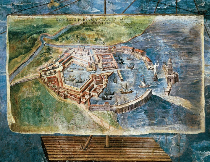
The Port of Trajan is the hexagonal basin you see from the window 30 seconds before landing at Fiumicino, and almost none of the passengers who look at it ever set foot there. It lies north of the mouth of the Tiber, inside a state archaeological area that opens onto Via Portuense at number 2360, under the viaduct of Via dell'Aeroporto di Fiumicino. The grain that fed Rome passed through here.
Let's clear up right away a confusion that causes half the misunderstandings: there are two ports, not one. The one of Claudius is the large basin open to the sea, begun in AD 42. The one of Trajan is the hexagon dug inland, between 100 and 112. The first is today almost entirely under the airport and under the reclaimed countryside. The second is still full of water, and the part with the water doesn't belong to the State.
The Port of Trajan is the visit that needs the most explaining before you do it. Not because it's difficult, but because people arrive convinced they'll walk along the edge of the hexagonal lake and instead walk among warehouses, quays and brick walls. The explanation has to come beforehand, not in front of the gate.
What the Imperial Ports of Claudius and Trajan are
The Imperial Ports are the artificial port system that Rome built for itself at the mouth of the Tiber when the city passed a million inhabitants and the old landing of Ostia Antica was no longer enough. The river was shallow, the sandbar at the mouth scraped the keels, large cargo ships couldn't go upstream. A real port was needed, dug into the land, connected to the river by canals.
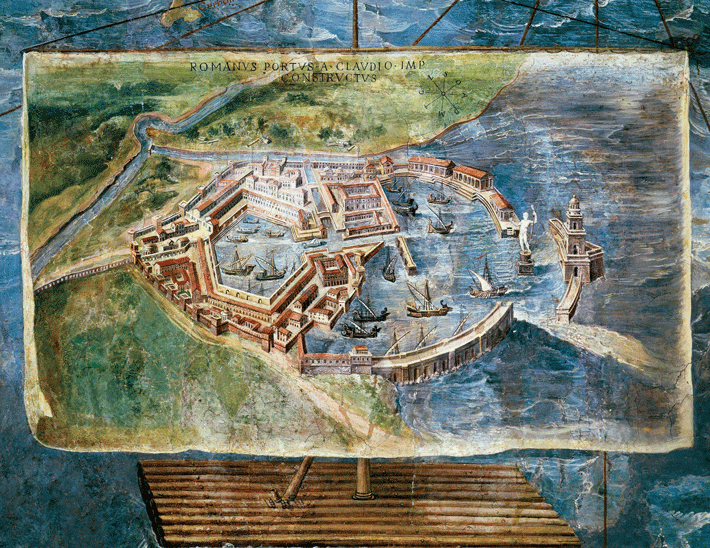
Claudius opened the building site in AD 42. The project included two curved moles reaching out into the sea, an artificial island at the center of the entrance and, on the island, a multi-story lighthouse. Modern sources don't agree on the surface area: the Ostia Antica Archaeological Park speaks of about 150 hectares of water, other reconstructions go down to about 70. The difference depends on what is counted, the inner basin or the whole protected anchorage.
Trajan stepped in half a century later because the port of Claudius, however enormous, was poorly sheltered. Between 100 and 112 a second basin was dug inland, hexagonal, 358 meters per side and about 32 hectares in area, around five meters deep. The quays were faced with travertine, and behind them ran the warehouses in several rows. It was a closed, defensible port, with always calm water.
The link with Rome was the decisive piece. The Fossa Traiana, the artificial canal that is still called the Fiumicino canal and is still navigated today, carried the goods from the basin to the Tiber. From there the barges went up the river to the city depots, where the shards of the unloaded amphorae built over the centuries the hill we call Monte Testaccio.
Around the two basins a city grew, Portus, with baths, a representative palace, a necropolis on the strip of land between the canal and the river, and later a bishop's see. It wasn't an appendage of Ostia: it was an autonomous center, which ended up draining the old river city. Anyone who visits Ostia Antica and then arrives here understands why Ostia lost its population.
Port of Claudius and Port of Trajan: what you really see of each
The right question to ask before buying the ticket is this: what is left standing of one and what of the other. The answer is asymmetrical and it's best to know it before leaving, because it determines how long it's worth staying and with what expectations.
Of the port of Claudius you see the negative
Of the basin of Claudius, in practice, you see the imprint. The runways and aprons of Fiumicino airport cover a large part of the water surface, the rest is countryside reclaimed in the 1800s. What remains are stretches of quay, the great portico that faced the water, the remains of the bath complex and the cistern of Monte Giulio. The lighthouse is gone, and there's no vertical ruin to photograph.
The story of the lighthouse, though, deserves to be told on the spot. To build its foundations the ship that had brought the obelisk from Egypt, the one that now rises in the middle of Saint Peter's Square, was sunk. A gigantic cargo ship, filled with concrete and sent to the bottom to serve as a base. Knowing this, in front of the apparent nothing of the dock, you start looking at the ground in a different way.
Of the port of Trajan you see the edge, not the water
The hexagon still exists, it's full of water and it's called Lake Trajan. The point is that the basin and most of its shores are private property, inside the estate called Oasi di Porto. The state archaeological area borders the lake but doesn't surround it: what you walk with the Park ticket are the port's service structures, not the circuit of the water surface.
Inside the state area you walk among the Trajanic warehouses lined up along the dock, the Great Warehouses of Septimius Severus, the so-called Imperial Palace that served as a representative residence, quays, moles and service walls. It's horizontal archaeology, of floor plans, of low brick. Anyone arriving expecting the Colosseum is thrown off.
The viewpoint that allowed a look over Lake Trajan from the state area appears to be temporarily closed according to the notice published by the Park, checked on September 28, 2026. It's the fact that most often ruins the visit of those who come specifically to see the water. Before leaving it's best to check the official page again, because these notices change without warning.
A curiosity about the Port of Trajan
The curiosity concerns the number of sides. A port is dug round, or square, or horseshoe-shaped: six sides serve no purpose from the point of view of navigation, and cost more in excavation and facing. Trajan's hexagon has 358 meters per side and a perimeter of over two kilometers of quay, all usable for mooring.
That is exactly where the soundest explanation comes from. A regular six-sided polygon maximizes the quay frontage relative to the dug water surface: more linear meters to dock at, fewer cubic meters of earth to remove. Each side becomes an autonomous sector, with its own warehouses behind it. It's logistical organization put on a plan, not geometric whim.
Then there's the symbolic reading, which circulates quite a lot and is worth handling with caution. You often read that the hexagon referred to imperial or astronomical meanings. The ancient sources are silent on this, and no Roman text explains the choice. When a symbolic explanation has no ancient line to support it, it should be presented as a modern hypothesis, saying so.
The project is attributed to Apollodorus of Damascus, Trajan's trusted engineer, the same man to whom we owe the bridge over the Danube and the complex still seen at the Trajan's Markets. The attribution is plausible given the chronology and scale of the work, but no inscription confirms it. Presenting it as certain would be incorrect.
The hexagon you see from the plane: where it is and who owns it
Anyone landing at Fiumicino from the north sees it on the left, a few seconds from touching down on the runway: a dark geometric figure surrounded by green, which doesn't look natural because it isn't. It's the basin of Trajan, the only Roman monument that millions of people a year look at from above without knowing what it is. Many mistake it for a settling basin of the airport.
Ownership is the key to everything. The area was reclaimed in the 1800s after Alessandro Torlonia bought it, and then passed by inheritance to the Sforza Cesarini family, who still hold it and who set up a nature oasis there in 1993. Hence the name Oasi di Porto by which the estate is known and under which it organizes its own visits.
This explains the anomalous access arrangement. The State manages the port structures, the private owner holds the water surface: two different tickets, two different calendars, two different entrances on the same Via Portuense. There is no single route that links them. Anyone who wants to see both the quays and the lake must plan for two separate visits, and on two different days if the calendars don't coincide.
The private estate publishes its own calendar of guided visits by reservation, roughly from October 15 to June 15, on limited days of the week and with last entry in the early afternoon, with a dedicated phone number. The fees don't appear to be published openly on a stable basis and change with the season: they have to be asked for by phone, and anyone who finds them written around on third-party sites should be careful, because they are often old.
One thing nobody tells you about the Port of Trajan
Nobody warns you that this is an archaeological site where the ancient landscape has been turned upside down twice. The first time by the sea, which withdrew: the coastline today runs about three kilometers further west than the Roman layout, so a seaport is visited in the middle of the countryside, without a thread of salt water in sight. The second time by the airport, built over the outer basin.
The practical consequence is that it takes an above-average effort of imagination. It's best to bring a printed plan, because without the plan the walls remain walls. If you go alone, do the same: study the floor plan beforehand, even just on your phone, because the signage on the spot is sober and the panels are not enough.
The second little-known fact concerns a building that came to light in 2009, during investigations of a British research project carried out together with Italian institutions. Under the Imperial Palace an elliptical building was identified, with an estimated capacity of around 2,000 seats, which the press of the time immediately renamed the little amphitheater of Portus. Its exact function remains debated among scholars.
Third thing you don't read in the guides: the noise. You walk among imperial ruins with planes taking off over your head every few minutes. For some it ruins the visit, I like it, because it's the only place in Italy where the function of the place hasn't changed one iota in 2,000 years. The goods of the Mediterranean arrived here then, they arrive here now.
Fourth thing, the least romantic. The site has no cafe, no restaurant, practically nothing within walking distance. The ground is uneven, in summer there's little shade and plenty of mosquitoes at sunset, in winter the mud after rain is serious. Closed shoes, water in your backpack, repellent from April onward.
Hours, tickets and opening arrangements, verified September 28, 2026
The archaeological area of the Imperial Ports of Claudius and Trajan is managed by the Ostia Antica Archaeological Park, which depends on the Ministry of Culture. It's not a municipal monument, so the phone channel of the Rome Civic Museums is of no use here: whoever calls the city number to reserve is knocking on the wrong door.
Days and hours
The area is open Tuesday to Sunday, holidays included, with entry from 10:00. Last entry changes with the season according to the calendar published by the Park: 15:30 from October 25 to the end of February, 16:15 in March, 16:30 from April 1 to October 24. Closed weekly on Monday, plus December 25 and January 1.
A clarification is needed here, because the place's reputation says the opposite. For years this area was visited only on set days, the first Saturday and the last Sunday of the month, by reservation and with free admission. That arrangement still appears on local institutional pages and on dozens of blogs copied from one another. The right calendar is the one published by the Ostia Antica Archaeological Park.
Tickets
The full ticket costs €6, the reduced ticket €2 for European Union citizens between 18 and 25, with the ordinary ministerial free admissions. There is an integrated ticket at €18, reduced €2, valid eight consecutive days on all the Park's sites. Every first Sunday of the month admission is free, as in all state sites.
The integrated ticket is the money-saving advice I give almost every time. With €18 you get into Ostia Antica, the Imperial Ports, the Ships Museum and the necropolis of Portus at Isola Sacra, spreading them over eight days. Three single tickets cost more and force you to squeeze everything into one day, which here is a terrible idea.
Reservation: needed or not
For individual visitors no reservation is required: you arrive, pay, enter. For groups and school classes the reservation goes through the Park's services concessionaire, with dedicated numbers and addresses active every day from 9:00 to 18:00. The switchboard of the Ostia Antica Archaeological Park answers every day during daytime hours.
The audio guide, where available, costs €5 in the two languages Italian and English. The guided tour is not included in the admission ticket, here as in almost all state sites. Anyone who wants an explanation has to book it separately or arrive with their own guide, and in that case the Park's rules on group access apply.
Two specific prohibitions that are best known beforehand. Drones are absolutely forbidden, because you are inside the Fiumicino airport airspace and the issue is not archaeological but flight safety. Picnics are not allowed inside the area. Dogs on a leash, on the other hand, are admitted, which is not a given at a state site.
My advice for visiting the Port of Trajan
The main advice is not to come here first. This site is only half understood if you haven't already seen how a Roman port city worked, and the way to see it is to go first to Ostia Antica, where warehouses, thermopolia, insulae and guild squares are preserved standing. Then you come here and the flat plans become readable.
Second piece of advice: half a day, not an hour. The area is large, the routes are long, the distances between one complex and another are covered on foot over uneven ground. Counting two full hours inside the enclosure is realistic, two and a half if you stop to read the panels. Anyone arriving at 15:00 in winter risks being escorted to the exit halfway through the route.
Third piece of advice, the one that saves the day: combine. The Ships Museum in Fiumicino, a short distance away, displays the vessels recovered in the 1950s and 1960s during the airport works, right inside the basin of Claudius. Seeing the hulls after seeing the port closes the circle better than any explanation. The necropolis of Portus at Isola Sacra adds the third piece, the funerary one.
Fourth piece of advice, on the season. The good time runs from October to May, with a preference for the clear days of November and March. July and August here are hard: little shade, glare, humidity from the reclaimed countryside. Anyone coming in summer should leave at opening and plan to be out by noon.
Last piece of advice, a practical one. Call or check the Park's website the day before, always. This is not the Pantheon, which opens anyway: it's an outlying site where a closure notice for works, weather alert or staff shortage can appear 24 hours ahead. The viewpoint on the lake, for example, has been closed for some time.
How to get here from Rome, by public transportation and by car
The entrance is at Via Portuense 2360, in Fiumicino, under the viaduct of Via dell'Aeroporto di Fiumicino. This is the reference published by the Ostia Antica Archaeological Park and the one to put in the GPS, as also reported by the Ministry of Culture listing. There are also conflicting kilometer indications on the same Via Portuense, at kilometer 25.600 or at 27: they are old and lead you astray.
By train and shuttle
The most reliable combination goes through the airport. From Roma Termini station the Leonardo Express reaches Fiumicino Airport with no stops. From the stations of Trastevere, Ostiense, Tuscolana and Tiburtina the regional line FL1 reaches the same airport with more stops and a lower fare. From Roma Trastevere you can also comfortably set off from Porta Portese on foot.
From the airport there is a free shuttle run by the airport operator that links Terminal 3 with the area of the Fiumicino archaeological sites, with a stop at the Ships Museum from Tuesday to Sunday from 9:30 to 18:30, according to the airport operator's website. The shuttle hours change and don't always coincide with those of the site: if you're counting on it, check at the terminal information desk as soon as you land, before setting out.
There are also intercity bus lines that run along Via Portuense between Rome and Fiumicino and stop along the road. I don't publish line numbers and stops because they change often, and a wrong line here means two kilometers on foot along a road without a continuous sidewalk. The exact route has to be checked the same day on the carrier's app.
If you arrive from the airports by plane and want to fit the visit into your arrival or departure day, you'll find the complete picture of connections in the page on how to get to the center from the Rome airports. It's a maneuver that works better on departure than on arrival, with your luggage already dropped off.
By car
By car you leave the Roma Fiumicino highway and take Via Portuense toward Fiumicino, following the signs for the archaeological area. The parking in front of the entrance is limited and unattended. A practiced alternative is to leave the car in a paid airport parking lot and take the shuttle, a convenient solution on crowded weekends.
If you're coming from the northern coast, from Fregene or from Lido di Maccarese, it's a 10-minute drive. From Marina di San Nicola and from Ladispoli you need 20 or 25. It's a pairing that works very well in spring: archaeology in the morning, sea in the afternoon.
Another well-known fact, yet rarely cited
Everybody knows Rome depended on grain from Egypt and Africa. Almost nobody draws the logistical conclusion: without these two basins the city could not have sustained a million inhabitants. The annual requirement was measured in hundreds of thousands of tons, and every ton passed through a quay, a warehouse, a barge and a porter.
The cycle worked like this. The cargo ships arrived from the eastern Mediterranean and North Africa between spring and autumn, unloaded at the quays of the hexagon, and the cargo went into the warehouses behind the mole. From there it passed onto the river barges, which went up the Fossa Traiana and then the Tiber under tow, to the city depots under the Aventine.
In winter the sea closed. Navigation stopped for months and the port warehouses became the capital's food reserve: public order depended on this. A late fleet meant dearer bread and unrest in Rome, and more than one emperor built his popularity on managing this mechanism, not on military victories.
This also explains the representative architecture inside a working area. The Imperial Palace, the baths, the decoration of the quays say that high-ranking officials passed through here and sometimes the emperor in person. A State port was also a political showcase, as the complex of the Imperial Forums was in the city.
If you want to see the other end of the chain in the city, there are two addresses. Monte Testaccio, the hill made of olive oil amphora shards, and the fabric of the district told by the Testaccio district open-air museum. The port ended there, between unloading and dumping.
The right photo to take at the Port of Trajan
The photo everybody wants, the one of the whole hexagon, doesn't exist from the ground. You need altitude, and altitude here is forbidden to drones for airspace reasons. Whoever has seen that image saw it from a satellite or from the window of a plane landing. It's worth saying right away, to avoid disappointment at the gate.
The real photo, the one that works, is taken with a telephoto lens on the dock and the warehouses. The subject is repetition: rows of identical brick rooms, arches all alike, the serial geometry of an ancient industrial plant. A raking late-afternoon light in winter brings out the texture of the bricks better than any summer noon.
Three framings I recommend
The first is the front of the Trajanic warehouses along the dock, shot at three-quarters to make the perspective run. The second is a tight detail on the facing of the quay, where the join between stone and brick tells how the edge was built. The third, the hardest, is the plane taking off over the ruins: it takes patience and a fast shutter speed.
If the day is the right one and the viewpoint on the lake should turn out to be reopened, the outlook over the water of the hexagon is the only point from which you sense the scale of the basin. Don't expect the recognizable geometric figure, though: from the ground you see a very long straight bank and nothing else. The shape is information the ground doesn't give back.
Last technical warning. The drone ban here is absolute and the penalties concern air navigation, not cultural heritage. It's not a rule you get around discreetly, because airport traffic is a few hundred meters away. If you want aerial footage of Roman ruins, shoot it elsewhere, for example on the Appian Way, where the rules are different.
Some important events that happened here in history
Claudius's building site, opened in AD 42, is the first event and the most underrated. Rome decided to build itself an artificial port where nature didn't offer one, moving millions of cubic meters of earth and sand with manual means. The inauguration came under Nero, and modern sources differ on the exact year between 54 and 64.
In AD 62 a storm sank an enormous number of cargo ships inside the basin of Claudius, according to tradition around 200. It was the practical demonstration that that port, open to the open sea, did not protect enough. From that disaster comes the decision, half a century later, to dig a second closed basin inside the first.
The excavation of the hexagon between 100 and 112 is the second event. It wasn't an enlargement, it was a change of concept: from the large and vulnerable port to the small and safe port, with quays on six sides and warehouses behind each. The difference between the two projects can still be read today on the plan of the area.
The city of Portus
Around the basins a real city consolidated, with its own statute and territory, which in late antiquity took a name tied to the Constantinian dynasty. Portus had basilicas, a bishop and a monumental necropolis on the strip of land between the canal and the river, Isola Sacra, which can today be visited with the same integrated ticket of the Park.
The diocese of Porto still exists today as a suburbicarian see, a sign of how much that center counted in ancient ecclesiastical geography. The necropolis of Isola Sacra, with its chamber tombs of the port's middle classes, tells who worked here: shipowners, merchants, craftsmen, doctors, bakers. It's a first-rate social source, and remains little visited.
Sieges and decline
In the fifth century the port became a military objective, because whoever controlled it starved Rome. The chronicles tell that during the sieges of the city the Gothic commanders occupied Portus precisely to cut supplies to the capital. The mechanism was known to everyone: no port, no grain, surrender in a few weeks.
During the Gothic War of the sixth century the complex changed hands several times between the Byzantines and the Goths, and the sources of the time describe its late antique fortifications. Those walls cut off its commercial function cleanly: from the logistics center of the empire to a garrisoned military stronghold. Traffic dwindled, the warehouses emptied, the maintenance of the canals ended.
Silting did the rest. The Tiber deposited sediment for centuries, the coast advanced, the basins turned to marsh and the zone became malarial. For a millennium the imperial port was a swamp with ruins in it, crossed only by shepherds and hunters. The orderly landscape you see today is the result of the land reclamation of the 1800s and 1900s.
Rediscovery and excavations
The excavations of the 1800s promoted by the private owners brought part of the structures back to light and produced the first reliable plans of the hexagon. In the 1900s the State acquired the area of the port structures, while the basin stayed private: hence the division that still shapes the way the site is visited today.
Between 1958 and 1965 the works for the new airport intercepted, inside the basin of Claudius, the wrecks of several ancient vessels of small and medium tonnage. Those timbers are now the core of the Fiumicino Ships Museum, reopened to the public after a long restoration and refitting project.
From 2007 onward an international archaeological mission has remapped the site with non-invasive methods, identifying unknown buildings, among them the elliptical one under the Imperial Palace. It is the research phase that has changed the understanding of the area over the last 20 years, and much of that work has not yet been translated into a visiting route.
Who passed through the Port of Trajan
Claudius is the first name on the list, and not only as the patron. The ancient sources describe an emperor who personally took charge of supplying the capital, going as far as guaranteeing the shipowners out of his own pocket against losses at sea to persuade them to sail even out of season. This port is that policy translated into masonry.
Nero completed the work and made propaganda of it, having coins struck with the image of the port and the ships. Those coins are now an important iconographic source, because they show the lighthouse and the moles when they still existed. Comparing the coins with the archaeological plan is one of the favorite games of the site's scholars.
Trajan and his technical entourage are the protagonists of the second phase. The name that recurs is that of Apollodorus of Damascus, designer of the forum and of the commercial complex that you visit at Trajan's Markets, and author of the bridge over the Danube sculpted on Trajan's Column. For the port the attribution remains probable, not documented.
Then there are the names we don't know, and that interest me more. On the gravestones of the Isola Sacra necropolis the trades of the port appear: who measured the grain, who carried it on their shoulders, who kept the accounts, who repaired the hulls. People who came from all over the Mediterranean, who lived here and stayed here.
In late antiquity pilgrims and bishops bound for Rome pass through here, because landing at Portus and going up the river was the normal route for those coming from the East. Whoever arrived by sea saw this port first and then the city. The Basilica of Saint Paul Outside the Walls rose along that river route.
In the 1800s the archaeologists and topographers pass through who published the first scientific plans of the complex, and in the 1900s the teams that dug out the wrecks during the airport works. In the last 20 years the research has been led by a foreign university mission in collaboration with the Park, whose scientific director has passed away, leaving work that continues.
A contrarian position on this visit
I'll say something enthusiasts don't like: for the average visitor the state archaeological area is worth more than the private Oasi, not less. The opposite idea circulates, that the real visit is the one to the hexagonal lake and that the rest is a fallback for those who can't get a reservation. In our judgment it's wrong.
The lake, seen from the ground, is a shoreline. Beautiful, quiet, full of birds, but a shoreline: the hexagonal shape can't be perceived, the ancient quay is largely not visible, and the interest becomes more natural than archaeological. Anyone who goes hoping for the image seen from the plane goes home with the feeling of having missed something.
The state area, on the contrary, has the structures: warehouses, quays, the palace, the baths, the walls that explain how the cycle of goods worked. It costs €6, opens six days out of seven without a reservation and you can decide the same morning. For someone with only one day, there is no doubt about the destination.
The second unpopular opinion concerns pairings. I often see the combination of the Port of Trajan plus the Colosseum or the Roman Forum proposed for the same day. It's a wrong day: two contexts very far apart in logic and in state of preservation, with an hour and a half of transfers in between. The port should be paired with the port.
Third uncomfortable position: this is not a site for everybody, and it needs saying. Anyone visiting Rome for four days who has never seen the Palatine, the Capitoline Museums or the Pyramid of Cestius shouldn't come here. It's a visit for a second or third trip, or for a curious resident.
What to see around it, to build a sensible day
The good radius around the Port of Trajan is 10 kilometers, and inside that radius is the whole Roman port system. The Fiumicino Ships Museum, on Via Alessandro Guidoni, displays the wrecks found in the basin of Claudius during the airport works and is open Tuesday to Sunday from 10:00, closing at 16:00 in winter and at 17:00 in summer.
The necropolis of Portus at Isola Sacra is the second piece of the system. It opens Tuesday to Sunday from 10:30 to 16:30, last entry at 16:00, with a ticket of €6 full and €2 reduced, and is reached from Via dell'Aeroporto di Fiumicino following the Park's signs. The chamber tombs of the port merchants are the port's social archive.
Ostia Antica remains the obligatory complement, and on its own it takes a whole day. If you have time, add the village of Ostia Antica, the 1400s castle and the medieval fabric right next to the excavations, which almost nobody visits and which you can walk in 40 minutes without a ticket.
Toward Rome, along Via Portuense
Heading back toward the city along Via Portuense you meet the necropolis of Via Portuense, which ideally closes the funerary theme begun at Isola Sacra. Further on the road enters the city at Porta Portese, where the ancient route and the modern one overlap almost without a break.
Anyone who wants to end the day on the Tiber has an embarrassment of choices among Ponte Sisto, the Tiber Island and the stump of the Ponte Rotto. The common thread is always the river as a transport route, which is exactly why the ports were built down there.
Among the big archaeological containers in the city, the Centrale Montemartini is the stop I recommend to those who appreciated the industrial logic of the port. Machines and statues in the same space, and a district, Ostiense, that also arises from a function as a freight yard.
Toward the coast and the northern shore
From the Port of Trajan the sea is a few minutes away. Fregene and the Lido di Maccarese round off an archaeological morning well, especially off season when the beach clubs are empty and the pine forest can be walked. From there the coast continues toward Marina di San Nicola and Ladispoli.
If you have a second day and want to continue the theme of ancient ports, head north. Civitavecchia is the port that Trajan built in almost the same years and that has kept working to this day, which Portus did not manage. The comparison between the two fates is the clearest geography lesson in Lazio.
Still to the north, the Etruscan world offers the pre-Roman counterpoint: the Banditaccia necropolis at Cerveteri and the painted tombs of Tarquinia. These cities lived off maritime trade centuries before Rome dug its first basin, and their landing places have almost entirely disappeared today.
For a day of fresh water and light archaeology there's Lake Bracciano, and for those chasing ancient ships the Museum of the Roman Ships of Nemi tells a different and equally instructive chapter of naval archaeology. They are two half-days, not two hours.
If there's time left in Rome
Anyone returning to the city with energy still to spare finds the natural completion in the area of the Imperial Forums, where the same patron left another complex of enormous scale. The Baths of Caracalla instead give an idea of the imperial volumes that at Portus can only be deduced from the foundations.
For the theme of water and infrastructure I recommend the Park of the Aqueducts and, for those who want the detail of a single channel still in operation, the story of the Aqua Virgo. Rome built for incoming water and incoming goods with the same engineering obsession.
On the front of imperial propaganda, the comparison closes among the Ara Pacis, the Mausoleum of Augustus and Castel Sant'Angelo. Three monuments that say in marble what the port says in brick: power is also measured in public works.
For a long outdoor walk there remain the Appia Antica Park with the Mausoleum of Cecilia Metella and the Villa of the Quintilii, or the view from the Janiculum. They are different days, but the same idea of the city.
Accessibility, children and real timing
The ground of the archaeological area is uneven, partly dirt and partly grass, with differences in level and rough stretches. The Park recommends comfortable shoes and does so for a reason. Anyone in a wheelchair or with mobility difficulties should ask at the ticket office which stretches of the route are practicable, because the answer changes with the season and the state of maintenance.
For children the site works on two conditions. The first is telling the story of the ships, the grain and the lighthouse before going in, because bricks alone speak to nobody under 12. The second is pairing it with the Ships Museum, where the real hulls do the work that the foundations can't.
Dogs on a leash are allowed, picnics are not. There are no internal refreshment points worthy of the name, so water and something to eat must be brought and consumed outside. In summer the sun is full for almost the whole route and shade is found only along some walls: the visit should be made at opening, not at noon.
On timing, the right measure is this: two hours for the archaeological area, an hour and a quarter for the Ships Museum, an hour for the Isola Sacra necropolis. Three sites in a day are feasible only by car and starting early. With public transportation, two at most.
Eating nearby, without getting fleeced
Around the archaeological area there's nothing: you eat in Fiumicino town, on the canal, or at Isola Sacra, and in both cases we're talking about fish. The zone has serious seafood cooking, with a fleet that unloads every day a few hundred meters from the tables. It also has, as a consequence, a high share of places that live off the airport's passing trade.
The first warning sign is the menu with photographs of the dishes. A kitchen that needs to show you the picture of a fried seafood platter means it doesn't trust your ability to read a name, and that its typical customer will never come back. It holds on the Fiumicino canal as in Testaccio, where the real markets have taught otherwise.
The second sign is the scene in the window. The lady rolling out the pasta sheet behind the glass or on the sidewalk is a lure, not a guarantee: in a seaside zone, moreover, fresh pasta displayed at the entrance says above all that someone has studied well where the tourists looking for a photograph pass. It says absolutely nothing about the cooking.
Third sign, the person at the entrance who invites you to sit down. A place with its own clientele doesn't need to recruit passersby on the sidewalk, and whoever does works on the flow, that is, on people who won't return. Fourth sign: a kitchen open nonstop from morning to night, with no break. It means reheating, not stoves lit on schedule.
Fifth and costliest: prices calibrated to the customer. It happens in front of the landings and in the photogenic little squares, where fish is sold by the hectogram, someone else decides the weight and items without a price appear on the menu. Definitive sign: a different price list for those sitting outside and those sitting inside. Ask the price per kilo before ordering, always.
On the chains with a repeated sign, the ones you meet in every historic center and also at the airport, this has to be said without snobbery. They work as a tourist attraction: they have consistent product, predictable lines and a promise they keep. Romans simply don't go there, and anyone traveling to eat Italian has far better options 500 meters away.
The single criterion, which almost never fails, is to look at who is seated and what language they order in. Tables of local families, airport workers on break, fishermen at the end of their shift: go in. Only suitcases and open maps on the table at 11:30 in the morning: move on and walk another 200 meters.
If you want a concrete reference instead of a general rule, you can start from Daniele's list of addresses on Google Maps, kept up to date over time and organized by zone. It's a starting point, not gospel: places change management and the list should be read together with the signs described above.
Last recommendation, valid throughout the zone. You eat early compared to Roman hours, because here the rhythm is set by work and not by tourism: at 13:00 the good dining rooms are already full, at 14:30 many kitchens really close. Anyone leaving the archaeological area at 14:00 risks finding open only the places they have no use for.
Frequently asked questions
Are the Port of Trajan and the Imperial Ports of Claudius and Trajan the same thing?
The official name of the state archaeological area is Imperial Ports of Claudius and Trajan, in the plural, because it includes the remains of both installations. Port of Trajan is the everyday name, also used by the people of the area, and refers mainly to the hexagonal basin. In practice there is a single ticket and it gives access to the same archaeological enclosure.
Can you see the hexagonal lake when you enter with the state ticket?
The hexagonal basin full of water, the so-called Lake Trajan, falls largely on private property and is not included in the route of the state area. There was a viewpoint that allowed a look over it, but it appears to be temporarily closed according to the notice published by the Ostia Antica Archaeological Park, checked on September 28, 2026. Anyone who wants to see the water must contact the private estate.
How much is the ticket and do you need to reserve?
The full ticket costs €6 and the reduced ticket €2 for European Union citizens between 18 and 25. The integrated ticket valid eight days on all the Park's sites costs €18. For individual visitors no reservation is required. For groups and schools the reservation goes through the Park's services concessionaire, whose call center answers every day from 9:00 to 18:00.
What days and hours is the site open?
It is open Tuesday to Sunday and on holidays, with entry from 10:00 and last entry varying with the season: 15:30 from October 25 to the end of February, 16:15 in March, 16:30 from April 1 to October 24. It is closed on Monday, as on December 25 and January 1. The calendar is that of the Ostia Antica Archaeological Park.
How do you get there from Rome without a car?
The most reliable way is the train to Fiumicino Airport, with the Leonardo Express from Termini or with the regional line FL1 from Trastevere, Ostiense, Tuscolana and Tiburtina, and then the free shuttle of the airport operator to the archaeological sites, which according to the airport operator's website stops at the Ships Museum Tuesday to Sunday from 9:30 to 18:30. The shuttle hours should be checked at the airport, because they change.
What is the difference between the port of Claudius and that of Trajan?
The port of Claudius is the outer basin, begun in AD 42 and inaugurated under Nero, open to the sea and today largely buried under the airport and the reclaimed countryside. The port of Trajan is the inner hexagon dug between 100 and 112, 358 meters per side, still full of water but privately owned.
How much time does the visit take?
Two full hours is the realistic measure for the state archaeological area, walked unhurriedly and reading the panels. Adding the Fiumicino Ships Museum takes another 75 minutes or so, and the necropolis of Portus at Isola Sacra asks for one more hour. A whole day comfortably covers two of the three sites, three only by car.
Can you use drones to film the hexagon from above?
Drones are absolutely forbidden over the whole area, because it lies right next to the airspace of Fiumicino airport. The ban is not about archaeological protection but flight safety, and the consequences are heavy. The only aerial image available to the public remains the satellite one or the one taken from the window of a landing plane.
Is the visit suitable for those coming to Rome for the first time?
For a first trip to Rome of four or five days the answer is no, and I say it against the interest of those who sell excursions. This site demands archaeological basics and the ability to read a plan, and pays off little in memorable images. It becomes an excellent visit on a second or third trip, or for someone who lives in Rome and already knows the center.
Who wrote this page
This page is edited by the team of Tour Leader Pro, the Roman structure that designs and coordinates visits, itineraries and cultural events in Rome and Lazio. The hours, fares and access conditions reported here were checked on the date indicated in the text against the institutional sources cited: before setting out it's best to check them again, because in this area they change often.
Anyone building an itinerary outside the center of Rome, with state sites on seasonal hours, private properties that open on set days, airport shuttles that don't match the openings and distances that look short on paper but aren't without a car, will find planning tools on Tour Leader Pro, designed both for those who lead groups and for those who organize on their own.
For the overall picture on trains, rentals, airports and destinations in Lazio beyond the center of Rome, from the coast to the lakes to southern Etruria, a useful resource is Italy Planner.