Ponte Nomentano
In short. You cross Ponte Nomentano on foot, for free and with no published hours: it is an outdoor pedestrian and cycle passage over the Aniene, which Turismo Roma places at Via Nomentana 434, in Monte Sacro, in Rome's Municipio III.
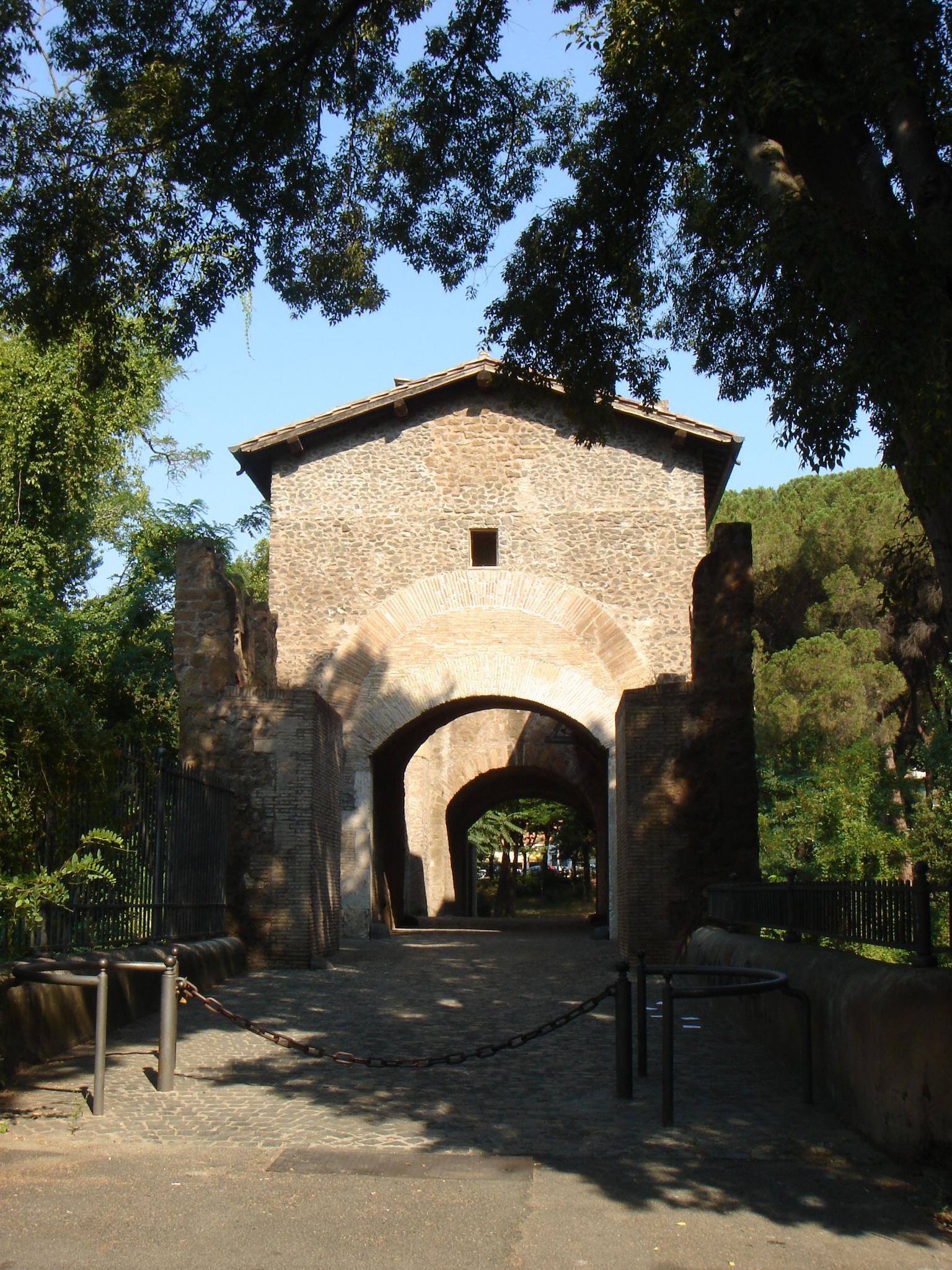
You cross Ponte Nomentano on foot, for free and with no published hours: it is an outdoor pedestrian and cycle passage over the Aniene, which Turismo Roma places at Via Nomentana 434, in Monte Sacro, in Rome's Municipio III. Protection of the monument belongs to the Capitoline Superintendency, while maintenance works are funded by Roma Capitale. The interior of the towers, on the other hand, has no regular opening and is seen only on rare visits by reservation. The bridge is at the edge of the Riserva Naturale Valle dell'Aniene, managed by the regional body RomaNatura.
The Roman bridge dates, according to the Superintendency, to a period between the late 2nd and early 1st century BC, when Via Nomentana crossed the river here at the foot of the Monte Sacro hill. Today it looks like a large travertine arch topped by a crenellated fortification, with two small ramp arches on each side. The castle part dates to the works of Pope Nicholas V, in the mid-15th century. For almost 30 years cars have no longer driven over it.
Data checked on September 29, 2026 on the Capitoline Superintendency's page for the bridge, on the Roma Capitale tourism portal, on the RomaNatura website and on the press report of September 18, 2026 announcing the restoration of the wooden walkway between the two towers. None of these sources publishes hours or fares for crossing the bridge, because there are none. None indicates a calendar of tower openings. For information on visits and initiatives the city's channel is the contact center 060608.
In brief: address, hours, ticket
- Address: Ponte Nomentano, Via Nomentana 434 according to Turismo Roma, Monte Sacro district, Municipio III, Rome.
- Operator: Capitoline Superintendency of Cultural Heritage for protection, Roma Capitale for works, RomaNatura for the surrounding reserve.
- How you get in: the bridge is crossed on foot or by bicycle, the towers have no regular opening.
- Price: free, no ticket for crossing.
- Hours: no published hours, the Superintendency lists it as visible from the outside.
- How to get there: area served by metro line B1, Conca d'Oro and Libia stations, routes and buses updated on the Atac website.
- Accessibility: the operator doesn't publish specific information, Turismo Roma refers to the Roma accessibile section.
Where it is and what you really see
The bridge is at the point where the ancient Via Nomentana, starting from Porta Pia and the Aurelian Walls, goes down toward the Aniene before climbing again toward Mentana. Modern traffic runs on a more recent bridge, not far away. The ancient one stays apart, among trees and meadows, and you reach it on foot. The hill rising on the north bank is Monte Sacro, which gives its name to the whole neighborhood and which tradition links to the first secession of the plebs.
Up close the monument is more compact than it looks in photos. The Superintendency describes a single large travertine arch, with a span of 15.1 meters, and two small ramp arches on each side. The fronts are in travertine blocks, while the underside of the arch is in Gabine stone, the volcanic stone quarried in the area of ancient Gabii. Above the arch runs the castle structure, with the two crenellated towers connected by the walkway.
Anyone arriving along the river sees the towers first of all. Then, as you get closer, the materials can be told apart: the travertine of the Roman arch, the more irregular masonry of the early medieval small arches, the parts rebuilt in the following centuries. The bridge works like a history book written in layers, and each era left its piece without erasing the previous one. It is this overlapping, more than any single detail, that justifies the visit.
Around it is the Aniene valley, with meadows, reed beds along the banks and pedestrian and cycle paths. To the east opens the Parco Nomentano, which the Touring Club describes as a green area between Via Nomentana and Via Tiburtina inside the reserve. To the west the river goes down toward Conca d'Oro and the Parco delle Valli, which Turismo Roma lists as part of the reserve, with about 21 hectares. The bridge acts as a hinge between these spaces and the neighborhood built on the hill.
The Aniene Valley Nature Reserve follows the river's urban course for several kilometers, and the Touring Club estimates it at about 6 million square meters. It is a protected area inside the city, with dense neighborhoods on both sides. The bridge is on its boundary, and from its back you can clearly see the two souls of the place: the Roman countryside that holds out along the water and the 20th-century buildings that surround it, a few hundred meters away.
Don't expect a fenced archaeological site. The bridge is a place of daily passage for those who live in Monte Sacro and the nearby neighborhoods, and it is crossed by cyclists, people with dogs, children heading to the park. For this very reason it must be respected: no climbing on the masonry, no climbing onto the ramps off the path, no writing on the stones. It is a protected monument, and its daily use depends on the care passersby take of it.
The neighborhood on the hill is young compared to the bridge. The Touring Club describes it as a garden city born about a century ago on the bank of the Aniene, with the aim of bringing houses and greenery to what was then a countryside area. Piazza Sempione, built in the 1920s, is its center. The contrast is sharp: in a few minutes on foot you go from a republican arch to apartment buildings with gardens, villini and tree-lined streets of the early 20th century.
A curiosity about Ponte Nomentano
Among the phases listed by the Superintendency there is one that few expect. In the 16th century a latrine was added to the bridge, later restored in the 19th century. It is the most domestic detail of a monument that is always told with popes, emperors and rebelling plebeians. A latrine only makes sense where someone stays a long time, and it suggests a stable presence of people on the bridge, probably those in charge of watching over it.
The published sources don't describe in detail who lived in the towers and with what duties. The general picture is clear, though: a fortified bridge on a consular road, at the gates of Rome, served to control who entered the city from the northeast. The castle above the arch was not a decoration. Look at the bridge with this idea in mind, and the towers stop looking like a romantic whim and go back to being a work built for a precise use.
The central pier also hid a practical device. The Superintendency recounts that the Roman bridge had two arches separated by a pier crossed by a flood window, an opening that served to discharge the water when the river rose. Without that window the current would have pushed against the masonry as against a dam. The Aniene is a river that swells quickly, and the Roman builders knew it well when they chose the shape of the bridge.
Another curiosity concerns ownership. The most widespread encyclopedia entry says that from the 10th century the bridge belonged to the monastery of San Silvestro in Capite, which in 1205 passed it to the church of San Lorenzo in Lucina, and that later it entered the holdings of San Pietro in Vincoli and of Sant'Agnese fuori le Mura. A bridge with its revenues was an economic asset, and it changed hands like a farm.
Something nobody tells you about Ponte Nomentano
The Mausoleum of Menenius Agrippa, which stands not far from the bridge in the Parco Caio Sicinio Belluto, bears a name that cannot be its own. Menenius Agrippa, the consul of the fable who according to tradition convinced the plebs to return to the city, would have lived in the 5th century BC. The tomb, according to the itinerary published by the Touring Club, is in yellow tuff, circular in plan, and dates to the 1st or 2nd century AD. Five centuries apart.
The name, then, is the neighborhood's tribute to the history that made it famous, not an archaeological attribution. The same goes for the park dedicated to Caio Sicinio Belluto, whom tradition names as the leader of the secession. Monte Sacro built its own identity around that story: the streets, the parks, the monuments. Knowing that it is a chosen memory, and not evidence on the ground, makes the walk more honest and, in our view, more interesting too.
The second thing concerns Charlemagne. Very many texts repeat that the pope and the king of the Franks met on the bridge in the year 800. The Enciclopedia dei Papi of Treccani, based on the Liber pontificalis and the Frankish annals, places instead the meeting of November 23, 800 at Mentana, at the 12th mile from Rome. The bridge is on the same road, much closer to the city. The link with Charlemagne is therefore a local tradition, not a documented fact.
How has the bridge changed in 2000 years?
The first version is Roman, of the Republican age. The Superintendency dates it between the late 2nd and early 1st century BC and describes it with two central arches separated by a pier, pierced by a flood window that let the water through when the river swelled. Other reconstructions, like that of the Touring Club and the most widespread encyclopedia entry, speak instead of three tuff arches with travertine archivolts. The sources don't agree on the number of the original arches.
In the 6th century war arrived. The Superintendency writes that the bridge suffered damage during the Gothic War, fought between 535 and 553, and the most widespread reconstructions speak of a refounding after the destruction by Totila. In the 8th century the side small arches were built, in concrete work with recovered material. It is the phase in which the bridge becomes a defensive structure, on the road that connected Rome to the Sabina.
On the date of the towers the sources diverge. The Touring Club and the most widespread encyclopedia entry attribute a first fortification with two towers to Pope Hadrian I, in the 8th century, with reinforcements in the 12th and 13th centuries. The Superintendency instead refers the crenellated castle structure to the works of Nicholas V, pope between 1447 and 1455. The two versions can be read together: an early medieval core, later rebuilt and raised in the 15th century into the form you see today.
The modern age added practical details. The 16th-century latrine, restored in the 19th century, is the last modification cited by the Superintendency before the 20th century. Then the bridge continued to serve Via Nomentana until the end of the last century: the most widespread encyclopedia entry and the Touring Club report that in 1997 it was closed to car traffic. Since then it has been a route reserved for pedestrians and bicycles, with a restoration that the same sources place in 2002.
The Superintendency also mentions a consolidation and conservative restoration of the whole bridge by the city administration, without giving the date. The last work documented by the press dates to September 2026: the replacement of the wooden walkway connecting the two masonry towers at the top, with an investment of €40,000 from the Infrastructure and Public Works Department of Roma Capitale. The old wooden structure was badly deteriorated.
The new walkway, according to the press reporting the announcement of the Public Works office, is about 10 meters long and 1.20 wide, with walking surface and load-bearing elements in wood like the previous one. The technicians improved the slope and the drainage of rainwater, to extend the life of the structure. Councilor Ornella Segnalini described the work as a targeted but important intervention, designed to preserve and secure a historic element of the bridge.
My advice for visiting Ponte Nomentano
My advice is to reach the bridge along the river, not from the road. Going down into the valley from the Parco Nomentano or from the reserve's paths, the monument appears from the side, with the towers reflected in the water when the current is calm. From Via Nomentana, instead, you meet it head-on and understand little of its shape. Allow for comfortable shoes, because the paths along the Aniene can be muddy after rain.
It's then worth choosing the moment. On weekend mornings the bridge is frequented by runners and cyclists, but stays quiet. In the late afternoon the low light warms the travertine and the towers take on a warm color. In summer the valley floor is humid and there are a few mosquitoes, so bring repellent. In winter, with the river higher, you understand why the Romans provided a flood window in the pier.
The last piece of advice concerns the time to devote. In our view the bridge alone is worth an hour, no more. It becomes a full half day if you fit it into a route that includes the Mausoleum of Menenius Agrippa, the Monte Sacro hill, Piazza Sempione with the Church of the Santi Angeli Custodi and a walk in the reserve. It is the right way to read the neighborhood, which without the bridge would not have the same history.
Anyone coming with children finds in the bridge a simple destination: no ticket, no line, space to run in the surrounding meadows. Keep an eye on the banks, though, which are not protected everywhere, and remember that the river can have strong currents even when it looks still. Other ideas for a family-friendly day in the city can be found among our entries, in Rome with children, which collects parks and easy places to visit.
Do you pay and can you enter the towers?
Crossing the bridge is free and requires no booking. Turismo Roma and the Superintendency list the monument as visible from the outside, and neither publishes hours. The bridge is a pedestrian and cycle route in a public green area. The towers are another matter: according to the press of September 2026 they used to host activities and workshops, but today no calendar of openings published by the city or the Superintendency appears.
The official channel for historical information is the page of Ponte Nomentano on the website of the Capitoline Superintendency. To find out if visits or initiatives are scheduled, it's best to contact the Roma Capitale contact center, number 060608, active every day from 9:00 to 19:00, or write to info@060608.it. Be wary of anyone selling tickets for the bridge: crossing is free and there is no paid entrance.
Visits inside the monument, when there are any, are organized by the Superintendency in the Archeologia in Comune program. The most recent example among those published on the website is from November 23, 2019: a free guided visit to the bridge and the Mausoleum of Menenius Agrippa, with mandatory booking at 060608 starting seven days before and a maximum of 25 people. For 2026 no similar event appears to have been announced.
Any walks, themed days or extraordinary openings may also be announced by other local players, with dates and arrangements that change from year to year and don't always appear on institutional channels. The advice is to check the pages of Municipio III and RomaNatura before organizing a visit with the idea of going up the towers. Without an event under way, you stay on the bridge and look from outside.
Another well-known fact, yet rarely cited
That Monte Sacro is the site of the secession of the plebs is repeated by everyone, starting from the plaques and street names of the neighborhood. The Treccani Dizionario di Storia dates the episode to 494 BC and recounts that Menenius Agrippa, with his fable, would have convinced the plebs to return to the city in exchange for the institution of the tribunes of the plebs. So far the best-known story, the one you learn at school.
The detail that is rarely cited is another. The same Treccani entry writes that the plebs withdrew to Monte Sacro or to the Aventine, and describes part of the narrative as probably legendary. The ancient sources, that is, didn't agree even on the place. Our opinion is that the neighborhood's exclusive identification with the secession is overrated: Monte Sacro is one of the two handed-down locations, not a certainty, and the episode itself is wrapped in legend.
It's worth remembering why the episode still weighs. The tribunes of the plebs, who according to Treccani were the prize for the return to the city, became one of the most important magistracies of the Republic, with the power to defend plebeians from abuses by patrician magistrates. Monte Sacro is therefore linked, in Italian civic memory, to the idea of a peaceful protest that wins rights. This is why the name has lasted 25 centuries.
The bridge, in any case, has little to do with the story. In 494 BC the stone bridge didn't yet exist, given that the Superintendency dates it to more than three centuries later. If the plebs really crossed the Aniene at that point, they did so on a ford or on a wooden structure of which no trace remains. The link between the bridge and the secession is geographic, not historical: the bridge is at the foot of the hill, and the hill bears the sacred name.
The right photo to take at Ponte Nomentano
The photo that tells the bridge is taken from the bank, at a distance, with the whole arch, the two towers and the reflection in the Aniene. You need a spot on the meadow beside the river, far enough to contain the whole monument, where the vegetation leaves room for the view. A normal lens is enough. The best light is that of the late afternoon, which warms the travertine and brings out the battlements of the towers against the sky.
The second photo is a detail: the arch seen from below, with the travertine blocks of the fronts and the underside of the arch in darker Gabine stone. It is the point where the hand of the Roman builders is best read. Don't go down onto banks where the ground is crumbly or slippery, and don't get near the water after rain. Even from a few meters away, with a slight telephoto lens, the blocks read well.
The small ramp arches also deserve a frame. The Superintendency dates them to the 8th century and describes them in concrete work with recovered material, that is, pieces taken from older buildings and reused. Up close you recognize fragments of brick and stone of different sizes, very far from the regularity of the Roman blocks of the main arch. A photo that puts the two masonries together tells the passage from antiquity to the Middle Ages in a single image.
The third possibility is the view from the top of the bridge, along the pedestrian path, toward the river and the Monte Sacro hill. It conveys well the monument's position, suspended between the green of the valley and the neighborhood. For anyone who loves the contrast between ancient and modern, the best photo includes the medieval towers with the buildings in the background. Avoid photographing people strolling without asking: for many it is the daily route home.
Foggy winter days give the bridge a different look, with the towers emerging from the mist of the valley floor. It takes patience and a cold morning, but the result has little to do with summer postcards. After rain, instead, the wet travertine turns darker and the veining reads better. In every season it's best to avoid the middle hours, when light from above flattens the masonry.
How do you get there from central Rome?
The simplest means is the metro. The walking itinerary in the neighborhood published by the Touring Club lists as reference points the Conca d'Oro and Libia stations of line B1, plus Ponte Mammolo on line B, also connected to the area by the GRAB cycle route. None of the official sources indicates the nearest stop or the minutes of walking. From the stop to the bridge the walk is not short, and it's best to calculate it beforehand with a map.
Anyone who prefers the bus finds on Via Nomentana several surface lines connecting the neighborhood to the center, but the numbers and routes change with works and reorganizations tied to the metro. The updated reference is the Atac website, with the route calculator. For the RomaNatura Casa del Fiume, seat of the reserve, the operator indicates lines 341 and 342, with a stop on Via Vicovaro, at the corner with Viale Kant.
On foot from the center it is a long but instructive walk. You start from Porta Pia and follow Via Nomentana north, passing beside Villa Torlonia, the Sant'Agnese complex and the Mausoleum of Santa Costanza. From there the road goes down toward the Aniene. It is a few kilometers, to be tackled in comfortable shoes and without hurry, perhaps stopping along the way.
By bicycle the bridge is reachable along the pedestrian and cycle paths of the Aniene valley, which connect Conca d'Oro, the Parco delle Valli and the Parco Nomentano. It is perhaps the best way to get there, because you see the bridge appear from the river as travelers used to see it. By car, instead, the advice is to avoid it: the bridge has been closed to traffic since 1997 and parking on the surrounding residential streets is scarce, especially on weekends.
Anyone riding a bicycle from the center can also use the GRAB, the Grande Raccordo Anulare delle Biciclette, which the Touring Club cites among the area's connections with the stations of metro B and B1. The full route is long and crosses many neighborhoods, but the stretch along the Aniene is among the greenest. It's worth checking the state of the paths in advance, because after floods some unpaved passages become difficult.
Some important events that happened here in history
The first event tied to the place is the secession of the plebs, which Treccani dates to 494 BC, placing it on Monte Sacro or on the Aventine. More than three centuries later, between the late 2nd and early 1st century BC, the stone bridge is built on Via Nomentana. In the 6th century the Gothic War, fought between 535 and 553, damages it, and according to the most widespread reconstructions the bridge is rebuilt after the destruction by Totila.
In the 8th century come the side small arches and, according to the Touring Club and the most widespread encyclopedia entry, the first fortification ordered by Hadrian I. On November 23, 800 Leo III welcomes Charlemagne at Mentana, at the 12th mile along the same road, and on December 25 crowns him emperor in Saint Peter's. Local tradition moves the meeting onto the bridge. From the 10th century the bridge belongs to the monastery of San Silvestro in Capite.
In 1205 the bridge passes to the church of San Lorenzo in Lucina, according to the most widespread reconstruction. Between 1447 and 1455 Nicholas V has the crenellated castle structure described by the Superintendency built. In the 16th century the latrine is added, restored in the 19th century. In the 20th century, on the hill beside it, the Monte Sacro neighborhood is born, which the Touring Club describes as a garden city that arose about a century ago on the bank of the Aniene. In 1997 the bridge is closed to cars.
The last chapters are recent. The encyclopedic sources cite a restoration in 2002. The Superintendency recalls a consolidation of the whole bridge by the city. On November 23, 2019 the Superintendency organizes a free visit to the bridge and the Mausoleum of Menenius Agrippa in the Archeologia in Comune program. In September 2026 Roma Capitale announces the restoration of the wooden walkway between the two towers, about 10 meters long and 1.20 wide.
Read in sequence, the chronology shows a bridge that has never stopped serving. It has been a consular road, a guard post, a church property, a vehicle crossing until the end of the 20th century and finally a pedestrian route inside a park. Each era modified it for its own needs, without demolishing it. It is rare for a Roman work on the outskirts to reach today with all its phases still readable on the same masonry.
Who has passed through Ponte Nomentano
The first to pass here, according to the Superintendency, were not people but animals. The point where Via Nomentana crossed the Aniene was traversed since antiquity by the herds of the transhumance, which went down and up between the Roman plain and the mountains of the Sabina. The bridge was born on an already beaten path, and for centuries shepherds, carts and merchants used this road to enter the city from the northeast.
Then came the wars. The bridge was damaged during the Gothic War, according to the Superintendency, and the most widespread reconstructions tie that damage to the destruction by Totila, the Gothic king who fought for a long time around Rome. In the 8th century Pope Hadrian I, according to the Touring Club, had the crossing fortified. The name of Charlemagne, whom tradition puts on the bridge in 800, is the most famous, even though the documents place the meeting with the pope farther away, at Mentana.
In the 15th century the protagonist is Nicholas V, the humanist pope whom the Superintendency lists as the author of the castle structure. After him the bridge remained for centuries among the holdings of Roman churches, crossed by travelers heading to the Sabina. In the 20th century came the inhabitants of the new neighborhood, who chose the secession as a founding myth and dedicated the streets to the protagonists of that story, from Menenius Agrippa to Sicinius Bellutus.
Today the bridge is crossed above all by those who live in the area. Students pass, people going to work by bicycle, families heading to the park, people jogging along the river. This is its current condition, more interesting than any organized visit: a 2,000-year-old monument that still does the job it was built for, namely carrying people from one bank of the Aniene to the other.
Charlemagne and the plebs: what do the documents say and what is told?
The documents say little, but precisely. The Superintendency dates the Roman bridge between the 2nd and 1st century BC, ties the crenellated towers to Nicholas V and the latrine to the 16th century. The Treccani Enciclopedia dei Papi, on the basis of the Liber pontificalis and the Frankish annals, including the Annales Laureshamenses, places Charlemagne's reception of November 23, 800 at Mentana, at the 12th mile from Rome, and specifies that this distance was reserved by ceremonial for the emperor.
Tradition adds the places of the neighborhood. It says that the meeting between Leo III and Charlemagne took place on the bridge, and the most widespread encyclopedia entry presents it as a local legend. It says that the plebs withdrew to Monte Sacro, the hill that overlooks the bridge, while Treccani recalls that the ancient sources also spoke of the Aventine. It says, finally, that the mausoleum in the park is the tomb of Menenius Agrippa, something the dating of the monument rules out.
Then there is the level of legend proper. The fable of Menenius Agrippa, that is, the comparison between the State and the human body in which the limbs rebel against the stomach, is for Treccani a probably legendary tale. That it was delivered precisely on Monte Sacro, and precisely in front of that plebs, has no proof. It is a useful story, which Italian schools have repeated for generations, and which the neighborhood has turned into an identity.
One detail curiously links the two medieval accounts. According to Treccani, the attack on Leo III of April 25, 799 took place near the monastery of San Silvestro in Capite. According to the most widespread reconstruction, from the 10th century the bridge belonged to that very monastery. No source connects the two things, and a link should not be invented. But the fact that the same name returns in both stories helps to understand how tight the network of churches and properties around Via Nomentana was.
What is around the bridge in the Aniene valley?
The bridge is on the boundary of the regional reserve managed by RomaNatura. The operator lists as its main seat the Casa del Fiume, at Via Vicovaro 21 at the corner with Viale Kant, open on Saturday from 10:00 to 13:00 and from 14:00 to 17:00 and on Sunday from 10:00 to 14:00, accessible to people with motor disabilities. A second access is at Via di Tor San Giovanni 301. Among the reserve's areas the operator lists the Pratone delle Valli, Saccopastore and the Cervelletta.
The Parco delle Valli, to the west, has two entrances listed by Turismo Roma, at Via Conca d'Oro 169 and Via Val d'Ala 19, with bike paths, play areas, sports facilities and a large black poplar among the trees pointed out. From the bank you can watch water birds such as mallards. The Parco Nomentano, east of the bridge, was inaugurated in 2008 according to the Touring Club. Together they form a continuous green strip along the river.
RomaNatura lists in the reserve sports facilities and picnic areas spread over several points, useful for those who want to spend the day outdoors. The advice is to bring water, a bag for trash and something to sit on, because services are not everywhere. In protected areas the operator's rules apply: no fires, dogs on a leash where indicated, respect for the vegetation along the banks and for the animals that live there.
The river itself deserves attention. The Aniene rises in the Monti Simbruini, passes through Subiaco, plunges in the waterfalls of Villa Gregoriana at Tivoli and reaches Rome after crossing the countryside. From its valley the Romans took water for some of their aqueducts, whose arches can still be seen in the Aqueducts Park. The bridge is one of the points where the river meets the city.
Anyone who loves Rome's historic bridges can put it in a series with the others. Milvian Bridge over the Tiber, where according to Treccani Leo III was welcomed on his return to Rome on November 29, 799, is its closest relative: a Roman bridge, fortified, tied to great battles. Ponte Sant'Angelo and Ponte Sisto tell instead of the city of the popes, inside the walls.
When is it closed and what not to expect?
The bridge has no published opening hours and no official source reports regular closures. It can, however, be closed during works, as happened with the walkway site in 2026, or in case of Aniene floods that make the paths along the river dangerous. In those cases the only way to know is to go or to ask the contact center 060608. With no works under way, crossing is free at any hour of the day.
Don't expect to enter the towers. The walkway restored in 2026 connects the towers at the top, but no source lists it as a route open to the public with fixed hours. Don't expect detailed explanatory panels, an information point or a ticket office either. The bridge is a monument inside a neighborhood park, and you read it with your eyes and a few notions in your pocket. Bring what you need to understand it, because on site the information is scarce.
Don't expect a monument isolated from the neighborhood either. The bridge is near busy roads, and at rush hour the noise of Via Nomentana reaches the river. Anyone seeking silence must move a few hundred meters away along the reserve's paths, where traffic fades and the sounds of water and birds prevail. Early in the morning, on holidays, even the bridge finds a certain calm.
Don't expect the Charlemagne scene either. The tradition that puts him on the bridge is rooted in the neighborhood, but anyone who arrives looking for a plaque or a material sign of that meeting comes away empty-handed. The same goes for the secession of the plebs: on Monte Sacro there is no dedicated archaeological site, only the name of the hill and of the streets. The bridge is Roman and medieval, and that is enough to make it one of the most complete monuments of the northern outskirts.
On summer evenings the paths along the river can be poorly lit, and the valley floor gets dark early. The advice is to visit the bridge in daylight, especially if you don't know the area, and to stay on the main paths. After heavy rains the meadows near the river can flood and some stretches become impassable. The bridge itself remains walkable, but the walk in the reserve is best postponed to the dry season.
Eating in the area
Around the bridge and along Via Nomentana there are places of every kind, and the neighborhood lives mostly off residents, which helps. The typical traps of the center are less frequent here, but they exist on the outskirts too: photo menus, items written with no price, places open nonstop with no kitchen break, fresh pasta made in the window as a show more than as work. They are signs to recognize in any neighborhood of the city.
Romans, in general, choose places where the menu has prices written, where the menu changes with the seasons and where the customers are regulars. Anyone arriving from the park with children and a bicycle is looking for a simple place, and in residential neighborhoods there are many. The advice is to avoid places that lure passersby with a tout on the sidewalk. To get your bearings there is the list of addresses on Google Maps curated by the editorial team.
In the good season the simplest alternative is a picnic. RomaNatura lists equipped areas at several points of the reserve, and the meadows of the Parco delle Valli and the Parco Nomentano are well suited to a break on the grass. Take away everything you brought, trash included, and don't leave food scraps on the meadows: they attract animals and dirty a protected area that the operator then has to clean.
What to combine in a day
The first pairing stays on Via Nomentana. Toward the center, before the bridge, you find the Basilica of Sant'Agnese fuori le Mura, with the catacombs, and the Mausoleum of Santa Costanza, with the early Christian mosaics of the vault. Even closer to the center is Villa Torlonia, with the Casino Nobile, the obelisks and the Jewish catacombs.
A second possibility leads west, toward Via Salaria. The Catacombs of Priscilla are on Via Salaria, near Villa Ada, the large park of the Trieste district, which can be paired with the bridge in a day devoted to greenery. A short distance away is the Coppedè district, with its fantastic early 20th-century architecture, and in the Villa Torlonia area there is also Villa Massimo, home of the German Academy.
Anyone who prefers to stay in the neighborhood can go up to Piazza Sempione, heart of the garden city of the 1920s, and visit the Church of the Santi Angeli Custodi, which the Touring Club dates to 1924. From there you head back toward the river passing the Mausoleum of Menenius Agrippa. It is a loop of a couple of hours that puts together the three layers of the place: the Roman and medieval bridge, the memory of the secession, the 20th-century neighborhood.
For a day entirely devoted to the Aniene, you can instead take the opposite direction and leave Rome toward Tivoli, where the river crosses Villa Gregoriana and where Villa d'Este and Hadrian's Villa are. Anyone looking for other ideas without spending finds suggestions among our entries, in free Rome, where the bridge fully belongs among the free visits.
Frequently asked questions
Do you pay to cross Ponte Nomentano?
No. The bridge is an outdoor pedestrian and cycle route, free and without a ticket. Turismo Roma and the Capitoline Superintendency list it as visible from the outside and don't publish hours or fares. The towers, on the other hand, have no regular opening. Anyone who wants to know if visits inside are scheduled can ask the Roma Capitale contact center, 060608, active every day from 9:00 to 19:00, or write to info@060608.it.
Did Charlemagne really meet the pope on the bridge?
According to local tradition yes, according to the documents no. The Treccani Enciclopedia dei Papi, based on the Liber pontificalis and the Frankish annals, places Leo III's reception of Charlemagne on November 23, 800 at Mentana, at the 12th mile from Rome, on the same Via Nomentana. The bridge is much closer to the city. The bridge tradition is rooted in the neighborhood, but has no confirmation in the ancient sources.
What does the bridge have to do with the secession of the plebs?
Little, from the historical point of view. The secession, which Treccani dates to 494 BC, would have taken place on Monte Sacro or on the Aventine, and the stone bridge was built more than three centuries later, between the 2nd and 1st century BC. The link is geographic: the bridge is at the foot of the Monte Sacro hill, which gives its name to the neighborhood and to its dearest memory.
Who built the bridge's towers?
The sources don't agree on the first phase. The Touring Club and the most widespread encyclopedia entry attribute a fortification with two towers to Pope Hadrian I, in the 8th century, reinforced in the 12th and 13th centuries. The Capitoline Superintendency attributes the crenellated castle structure to the works of Nicholas V, pope between 1447 and 1455. What you see today, with the battlements and the two towers, corresponds to the 15th-century phase described by the Superintendency.
Can you cross the bridge by bicycle?
Yes. Since 1997, according to the Touring Club and the most widespread encyclopedia entry, the bridge has been closed to cars and reserved for pedestrians and bicycles. It lies along the pedestrian and cycle routes of the Aniene valley, which connect the Parco delle Valli, the Parco Nomentano and the other areas of the reserve. At the busiest times it's best to slow down and give way to those on foot, because the crossing is shared by everyone.
Is Ponte Nomentano wheelchair accessible?
The operator doesn't publish specific information on the bridge's accessibility, and Turismo Roma refers to the Roma accessibile section of its portal. The valley's paths are partly unpaved and can be muddy after rain. For the reserve, RomaNatura lists the Casa del Fiume at Via Vicovaro 21 as accessible to people with motor disabilities. Before setting out, it's best to ask for updated information from the contact center 060608.
What was restored in 2026?
According to the press of September 18, 2026, which reports the announcement of the Public Works office of Roma Capitale, the wooden walkway connecting the two masonry towers at the top of the bridge was replaced. The new structure is about 10 meters long and 1.20 wide, with an improved slope and a rainwater drainage system. The work cost €40,000, funded by the Infrastructure and Public Works Department.
Where exactly is Ponte Nomentano?
Turismo Roma lists it at Via Nomentana 434, in the Monte Sacro district, where the ancient consular road crosses the Aniene at the foot of the hill that gives the area its name. Modern traffic runs on a more recent bridge, and the ancient one is reached on foot from the meadows and paths around it. It lies at the edge of the Riserva Naturale Valle dell'Aniene, between the Parco Nomentano to the east and the river's course toward Conca d'Oro.
How much time do you need to visit it?
For the bridge alone an hour is enough, the time to look at it from the bank, cross it and observe the details of the arch and the towers. It becomes a half day if you pair it with the Mausoleum of Menenius Agrippa, Piazza Sempione and a walk along the Aniene. With stops along Via Nomentana, at Sant'Agnese, Santa Costanza and Villa Torlonia, you easily fill a whole day without moving far from the same road.
Who wrote this and on which sources
The text comes from the editorial team of Tour Leader Pro, the Rome-based outfit that designs itineraries, tours and cultural events in Rome and Lazio. The fares, hours and booking arrangements given here come from the official sources cited in the text, as of the date given at the start: for Ponte Nomentano the references are the Capitoline Superintendency page, the Roma Capitale tourism portal, the RomaNatura website and the September 2026 news on the walkway. Tell us what you find has changed.
Organizing a stop at Ponte Nomentano for many people seems easy, because there are no tickets or turns. The real difficulty is logistics: the distance from the metro stops, the paths that turn muddy after rain, the crossing shared with cyclists and residents. It's best to set the meeting point in the park and not on the bridge. For anyone planning cultural outings in the city, a useful resource for people who organize group travel is Tour Leader Pro.
Ponte Nomentano is also a stage of the long road that leads from the city toward the Sabina and the sources of the Aniene. Following the river and the consular road out of the capital leads toward Tivoli, Subiaco and the Abbey of Farfa, territories that deserve a multi-day trip. Putting together city and province takes a bit of planning, and a useful resource for building a multi-day itinerary is Italy Planner.