Ponte Flaminio
In short. You cross the Ponte Flaminio on foot, for free and at any hour: it's the large travertine road bridge that carries corso di Francia over the Tiber, between the Parioli district and Tor di Quinto, a little upstream of Ponte Milvio.
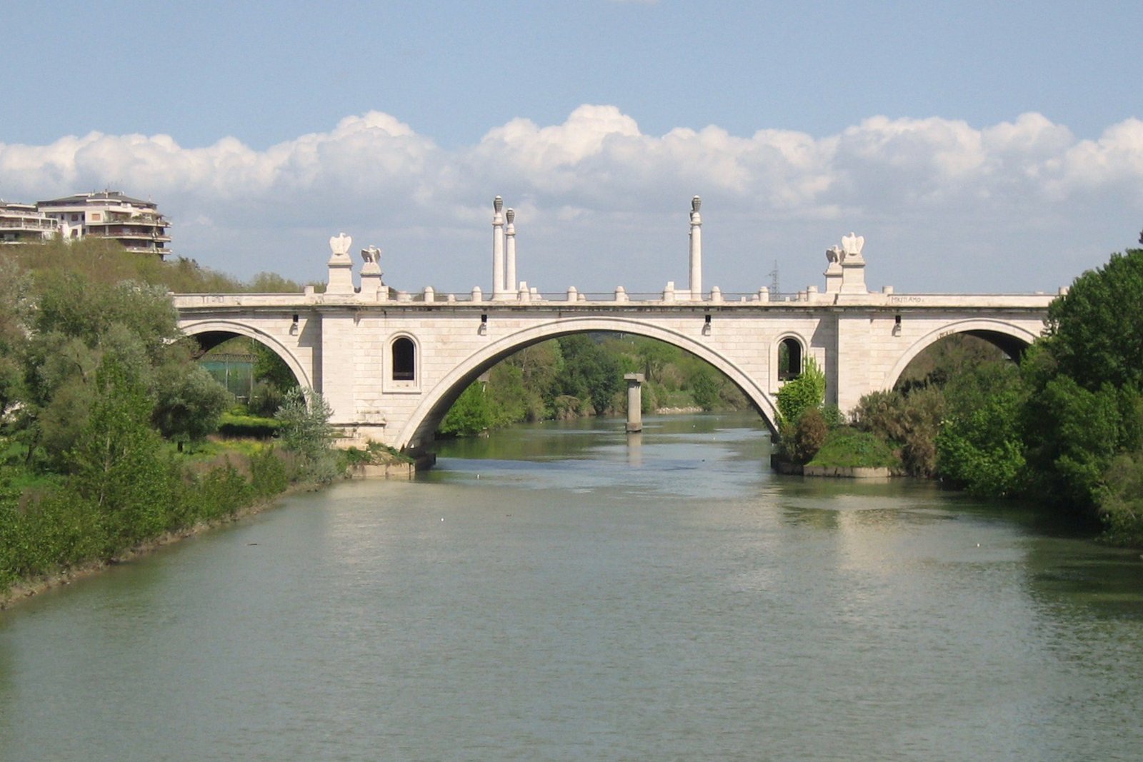
You cross the Ponte Flaminio on foot, for free and at any hour: it's the large travertine road bridge that carries corso di Francia over the Tiber, between the Parioli district and Tor di Quinto, a little upstream of Milvian Bridge. There are no tickets, hours or reservations. It's a Roma Capitale road, used every day by heavy traffic, with two raised sidewalks for pedestrians. It was designed by the architect Armando Brasini, and the work lasted from 1938 to 1951.
Anyone who knows it only from a car remembers it as a wide, fast passage toward the Cassia and the Flaminia. Seen on foot it's something else: a work conceived in the 1930s as a monumental gate to the city from the north, with eagles above the columns, lanterns, stairs that go down toward the river and a continuous cladding of light travertine. In September 2026 the City switched on new lighting, after the cleaning of the travertine completed in 2025.
Data checked on September 29, 2026 on the Turismo Roma page dedicated to the bridge, on the ANSA news item of September 28, 2026 on the new lighting, on the report of the local paper VignaClaraBlog, on the roma2pass portal dedicated to the Tiber and on the encyclopedia entries cited further on. For the bridge there are no fares or hours, because it's a public road. For works, closures and detours the City's channel is the 060608 contact center, active every day from 9:00 to 19:00.
At a glance: address, hours, ticket
- Address: Ponte Flaminio, along corso di Francia, between the lungotevere dell'Acqua Acetosa and the lungotevere Salvo D'Acquisto (Parioli side) and the Tor di Quinto bank, Rome.
- Operator: city bridge of Roma Capitale, the recent works were overseen by the Public Works Department, for information the 060608 contact center.
- How to get in: you walk it on the two raised sidewalks, at any time, beside the vehicle traffic.
- Price: free, no ticket.
- Hours: no hours, the bridge is always open except for temporary closures decided by the City.
- Getting there: from the center take metro line A to Flaminio and then tram 2 toward piazza Mancini, checking the line's status on the Atac site, then on foot along the river.
- Accessibility: the City publishes no specific information for the bridge, for particular needs it's best to call 060608.
Where it is and what you actually see
The bridge spans the Tiber in the stretch north of the city, where the river has just received the Aniene and bends toward Ponte Milvio and the Foro Italico. On the Parioli bank the viaduct of corso di Francia joins in, passing over the Villaggio Olimpico. On the opposite bank the road continues toward Tor di Quinto and Vigna Clara. It's the most direct link between via Flaminia and via Cassia, and that's why the traffic never stops.
On the Parioli side the bridge marks the border between two lungotevere. Upstream runs the lungotevere dell'Acqua Acetosa, which reaches as far as the mouth of the Aniene. Downstream begins the lungotevere Salvo D'Acquisto, which goes down to piazzale Cardinal Consalvi, at the entrance to Ponte Milvio. The two bridges are close, and from one you see the other. It's a pair to read together: the ancient stone bridge, downstream, and its 20th-century heir, wider and higher, upstream.
The structure is reinforced concrete entirely clad in Roman travertine, in warm, light tones. Turismo Roma and the English encyclopedia entry give a length of 254.94 meters and a width of 27. The number of arches changes depending on the source: seven for Turismo Roma, five for the encyclopedia entry and for ANSA. The site Sotterranei di Roma describes a central arch of 52 meters, a depressed arch, the widest, which carries the most decorated part of the deck.
On the raised sidewalks rise columns and cylindrical shafts of travertine that carry the eagles and the lamps. Turismo Roma reads the eagles as a symbol of Roman military power and the whole as a direct reference to imperial architecture. The bridge has no groups of statues on the parapets like Ponte Sant'Angelo. Its decoration is made of a few repeated elements, on a large scale, designed to be seen even by people passing at speed.
On the Tor di Quinto bank the landscape changes. Corso di Francia continues north, toward Vigna Clara and via Cassia, among residential buildings of the second half of the 1900s and big intersections. It's the part of the bridge that interests least those who come to look at it, but it explains its function: carrying the traffic of the northern consular roads into the city without going over the ancient bridge. Anyone arriving on foot can stop at the end and come back on the other sidewalk.
Don't expect a monument to visit in silence. The Ponte Flaminio lives on traffic, with cars running on two carriageways separated by a central divider. The sidewalks are wide, but the noise covers every pause. Its value is measured in scale and position: it's one of the last great monumental bridges built in Rome in the 1900s, and from the middle of the span you take in the whole bend of the river between the Acqua Acetosa and Ponte Milvio.
A curiosity about the Ponte Flaminio
The bridge changed its name before it was even finished. The project was born as Ponte XXVIII Ottobre, from the date of the March on Rome, according to roma2pass and the English encyclopedia entry. After the war that name was no longer possible. Turismo Roma writes that the bridge was inaugurated in 1951 as Ponte della Libertà and took the name Flaminio only in 1961. Roma2pass maintains instead that the name of Libertà was only planned. The sources don't agree.
The final name does not refer to the Flaminio district, which is further downstream. The English encyclopedia entry explains that the bridge was named this way to tie it to corso di Francia, then called via Flaminia nuova, the road of which the bridge was the stretch over the river. The name, therefore, points to the consular road and its modern doubling. Anyone coming from the center following the historic via Flaminia doesn't pass here but over Ponte Milvio.
Then there's a detail that escapes almost everyone. The site Sotterranei di Roma points out, along the bridge, stone markers with inscriptions indicating the stretches of the ancient consular roads. They are small and go unnoticed beside the columns with the eagles. It's worth looking for them while walking on the sidewalk: they are the point where the bridge declares its function, that of a junction between the roads that entered Rome from the north.
The form too has a precise model. The English encyclopedia entry observes that the design of the bridge takes up that of nearby Ponte Milvio, with enormously accentuated proportions. Placed side by side, the two bridges tell the same idea 2,000 years apart: stone arches, a passage on the road that comes from the north, an entrance to the city. The 20th century took the Roman bridge and enlarged it, adding the insignia of power.
The bridge, then, does not end where the river ends. On the Parioli bank the road continues on the viaduct of corso di Francia, built according to roma2pass nine years after the inauguration, in view of the 1960 Olympics, with slender piers above the Villaggio Olimpico. Anyone looking from above sees a single continuous axis, but they are two works of different eras and languages: the travertine and the eagles of the bridge, the exposed concrete and essential lines of the viaduct.
One thing nobody tells you about the Ponte Flaminio
After a few years in service, the bridge risked collapsing. Roma2pass and the English encyclopedia entry tell that in the early 1960s the fifth pier gave way. The bridge was closed, and to avoid interrupting traffic a temporary Bailey-type bridge was installed, upstream. The consolidation work was overseen by the engineers Arrigo Carè and Giorgio Giannelli, and the Ponte Flaminio reopened in 1964. 11 years after the inauguration, the monumental gate of Rome was already a construction site.
The second thing that is little said is that the bridge soon lost the function for which it was born. Roma2pass observes that with the Grande Raccordo Anulare and the Fiumicino airport the traffic entering the city took other roads. The Ponte Flaminio is no longer the north gate of Rome. It has become a neighborhood artery, very busy, connecting the Parioli and the Villaggio Olimpico with Tor di Quinto, Vigna Clara and the Cassia.
A clear position, in our view: the Ponte Flaminio is too often dismissed as a piece of regime rhetoric, to be crossed without looking. That's a mistake. The work was completed by Republican Italy, carries a name that has nothing celebratory about it and represents one of the best examples in Rome of how a large concrete bridge dressed in stone was built. It deserves an hour on foot more than many monuments of the center photographed in a rush.
Finally a detail on the recent works. The new lighting switched on at the end of September 2026 has not yet involved the historic lanterns. According to ANSA and VignaClaraBlog, eight lanterns are under restoration in agreement with the state Soprintendenza, and two of them, a large one and a small one, are in the lab to study technical solutions. Anyone passing in the coming months may find some lanterns off or missing, and it is not neglect.
Why did Rome build a second bridge upstream of Ponte Milvio?
The answer is traffic. The site Sotterranei di Roma explains that in the 1930s Ponte Milvio could no longer handle the flow of vehicles coming from via Cassia and via Flaminia. An ancient bridge, narrow and with its ramps, had become a funnel. Roma2pass places in 1930 the approval of the urban plan from which the idea of the new crossing was born, a little further upstream, along the route of a new road.
The traffic problem was joined by a political ambition. According to the site Sotterranei di Roma, the goal was to give the capital a monumental entrance from the north, able to compete with those of the great European capitals. The bridge was meant to welcome those arriving by car with a scenography of stone, eagles and lanterns. The Foro Mussolini, today the Foro Italico, was a little further downstream, on the other bank, and completed the picture.
Brasini had thought of something even bigger. Roma2pass and the English encyclopedia entry report that the original project included an enormous monumental arch on the model of Roman triumphal arches. Mussolini had it removed and asked for the design to be simplified. The bridge we see is therefore the reduced version of a much more theatrical idea, and still bears the mark of that cut in the almost austere measure of its decorations.
Construction began in 1938 according to Turismo Roma and the English encyclopedia entry, in 1939 according to ANSA and VignaClaraBlog. The technical direction was by the engineer Aristide Giannelli, whom roma2pass presents as a professor of construction science at the Faculty of Engineering of Rome. The contractor is given as Tecnobeton by Turismo Roma and as Ferrobeton by roma2pass. In 1943 the work stopped because of the war and the damage suffered by the site.
The site resumed in 1947, in a Rome that had to rebuild much more than a bridge, and the Ponte Flaminio was inaugurated in 1951. Nine years later, for the 1960 Olympics, roma2pass recalls the construction of the viaduct of corso di Francia, with its piers above the Villaggio Olimpico area. Brasini's bridge thus became the final piece of a new road axis, which rose from the Flaminia toward the north crossing the river.
How is the bridge made, piece by piece?
We start from the structure. Under the cladding is reinforced concrete, which carries the arches and the deck. The site Sotterranei di Roma describes the central arch, 52 meters wide, with a depressed arch, that is flatter than a semicircle. It's the solution that allows a wide span over the river without raising the road too much. The other arches, smaller, follow the carriageway toward the two banks and support the ramps.
Above the structure is the skin of stone. Turismo Roma speaks of Roman travertine in warm tones, laid over the whole bridge. The cleaning completed in 2025 gave back exactly this color, which for decades had disappeared under the smog of a very busy road. Look at the parapets up close: the new raking light, according to ANSA, was designed to bring out the grain of the stone after sunset.
Then there are the vertical elements. Columns and cylindrical shafts rise on the sidewalks and carry the eagles and the lamps. On the central arch, according to the site Sotterranei di Roma, four eagles and four lanterns similar to lighthouses are concentrated, marking the highest and most decorated point of the bridge. The rhythm is simple and regular, readable even at car speed, and that was exactly the aim of the design.
Finally the road. The two carriageways are separated by a central divider, on which the new lighting has mounted 98 fixtures, 49 per direction of travel according to ANSA. On the sides run the two raised sidewalks, with another 124 semi-recessed fixtures. The stairs connect the sidewalks with the lower levels, and the markers with inscriptions recall the consular roads that the bridge was meant to serve. Everything else is traffic.
The advice I give you for visiting the Ponte Flaminio
My advice is not to just cross it by car. The Ponte Flaminio is only understood on foot, and it's at its best within a walk along the river that starts from Ponte Milvio. Go down along the lungotevere Salvo D'Acquisto, watch the bridge grow as you approach, climb onto the sidewalk and walk it to the middle. From there come back on the other side, to see the bend of the river in both directions.
Choose the hour carefully. At peak hours the traffic on corso di Francia is continuous and loud, and stopping on the sidewalk becomes unpleasant. Sunday morning is the quietest time. At sunset the travertine takes on the warm color the sources describe, and after dark you see the new lighting, with the raking light that the design directs onto the parapets. They are two different visits, both worthwhile.
Look at the bridge from below too. The stairs that the English encyclopedia entry calls scenographic connect the sidewalks with the lower levels, and from the bank you can read the arches and the stone cladding well. Before going down, check the state of the river: after heavy rain the areas near the water can be muddy or off limits. In that case stay on the lungotevere and don't look for improvised ways down to the bank.
Bring water in the warm months, because on the bridge there is no shade and the travertine reflects the sun. In the neighborhood there are public drinking fountains, and the general information is collected in the page dedicated to the nasoni of Rome. Comfortable shoes, a little attention at the pedestrian crossings on the lungotevere and half an hour are enough to see the bridge calmly. With Ponte Milvio and the river, count on a good hour.
If you can, come twice. The first time by day, to read the arches, the color of the travertine and the relationship with Ponte Milvio. The second after sunset, to see the bridge with the new light, when the stone of the parapets stands out from the dark and the columns with the eagles become sharp silhouettes. Between the two visits there is time for a walk in the neighborhood or for a concert at the Auditorium, which is on the same bank.
Do you pay anything to cross it?
No. The Ponte Flaminio is a public road of Roma Capitale and you cross it for free, on foot, by bike or by vehicle, at any hour of the day and night. There is no ticket, there is no reservation, there is no opening time. The City's tourism pages describe it as a work by Armando Brasini without indicating any visiting services. For works, traffic closures or extraordinary events the reference is the 060608 contact center.
There are no sales channels to point out for the bridge, and be wary of anyone offering a ticket to cross it or to go up the stairs. Anyone who wants a historical reading of the area will find offers from private operators and cultural associations, with prices and calendars published on their respective sites. For the bridge itself no service is needed: everything there is to see can be seen from the sidewalk and the banks, for free, in any season.
The only costs of the walk are those of public transport, with the Atac ticket for metro and tram, and whatever you decide to spend along the way. If you combine the bridge with a concert at the Auditorium Parco della Musica or an exhibition at the MAXXI, the tickets are bought on the official channels of those venues. The bridge has nothing to sell, and that is one of its merits.
Another well-known fact, yet rarely cited
Many Romans know that the Ponte Flaminio appears in Caro diario, Nanni Moretti's 1993 film. Few remember what it's doing there. Turismo Roma and the English encyclopedia entry report that in the film the director openly declares his love for the bridge and tells of crossing it at least twice a day. It's one of the rare declarations of affection in Italian cinema for a 20th-century work of architecture, and it changed many people's view of the bridge.
The detail matters, because in Caro diario the bridge appears as a personal choice, not as a backdrop. Anyone who wants to follow the traces of cinema in the city finds a route on the page Rome in the movies. The Ponte Flaminio belongs there by right, even though it rarely appears in the lists of the best-known film locations.
A second well-known and rarely cited fact concerns the material. Everyone sees the white of the bridge and thinks of a stone work. Turismo Roma specifies that the load-bearing structure is reinforced concrete, entirely clad in Roman travertine. It's the typical technique of the great public works of the 1930s: concrete to hold up, stone to represent. The travertine, in this sense, is a garment, and for exactly that reason it must be cleaned and protected regularly.
The last cleaning before the recent one dated back many decades. According to VignaClaraBlog, the cleaning and protection treatment of the travertine, which cost 600,000 euros, was completed in 2025. ANSA adds this figure to the 310,000 euros of the new lighting, for a total investment of about 900,000 euros. Anyone who has in mind the gray, blackened bridge of past years will find a much lighter surface today.
There's also a fact that concerns those who use the bridge every day without thinking about it. Its eagles, columns and lamps were designed to be read from a moving car, in an era when the car was still a symbol of modernity. Today that same speed prevents you from seeing them. The paradox of the Ponte Flaminio is all here: a monument designed for drivers, which is really appreciated only by getting out of the car and walking on the sidewalk.
The right photo to take of the Ponte Flaminio
The best photo of the bridge is taken from a distance, from the lungotevere Salvo D'Acquisto, walking from Ponte Milvio upstream. From there the bridge appears at three-quarters, with the arches reflected in the river and the row of columns above the parapets. In the late afternoon the light falls on the travertine and warms it. A medium lens is enough, a wide-angle helps keep the trees on the bank in the frame too.
From the bridge itself, the photo to take is downstream. In the foreground are the columns with the eagles, in the background you see the bend of the river going down toward Ponte Milvio. It's the framing that best tells the relationship between the two bridges, the ancient and the modern. Wait for a moment with no cars on the sidewalk and stand next to the balustrade, without leaning out and without climbing on any element of the bridge.
In the evening the photo changes. The new lighting, according to ANSA, counts 222 fixtures: 98 on the carriageways, mounted on the central divider, and 124 semi-recessed along the two sidewalks, divided into four groups, with a raking light aimed at the travertine parapets. The result photographs well from the banks, with long exposures and a stable support. The light trails of the headlights on the bridge are part of the image.
A detail not to overlook is the eagles. Photographed up close, from the sidewalk, they tell the language of the bridge better than any overall view. Look for a framing from below, with the sky in the background, and an hour when the sun is not behind the sculpture. Respect the traffic: photos are taken from the sidewalk, never from the roadway and never stopping on the pedestrian crossings.
How do you get there from the center of Rome?
By public transport the simplest solution is metro line A to the Flaminio stop, in piazzale Flaminio, next to the Porta del Popolo. From there tram 2 departs, going up via Flaminia as far as piazza Mancini. The line has been suspended several times in recent years for works and replaced by buses, so it's best to check the service status on the Atac site on the day of the visit. From piazza Mancini you continue on foot along the river.
From piazza Mancini you reach Ponte Milvio walking along the lungotevere, and from Ponte Milvio you continue on the lungotevere Salvo D'Acquisto to the Ponte Flaminio. It's the most pleasant route, because it lets you see the ancient bridge first and then the modern one. Anyone who prefers to arrive from corso di Francia by bus must check lines and stops on the Atac site, because the routes in the area change often.
On foot from the historic center the route is long but straightforward. From piazza del Popolo you go up via Flaminia, pass beside Villa Poniatowski and the Etruscan Museum of Villa Giulia, cross the Flaminio district and arrive at Ponte Milvio. Alternatively you can follow the Tiber along the lungotevere, passing in front of the Foro Italico on the opposite bank. Count on more than an hour of walking.
By bike the Tiber offers the best solution, with the bike path along the embankments that goes up the river from the center toward the north. To get up on the bridge you have to return to street level. By car the area is congested at peak hours, and parking around Ponte Milvio is almost always difficult, especially in the evening. On match days at the Stadio Olimpico the traffic in the area gets even worse.
Some important events that happened here in history
In 1930, according to roma2pass, the urban plan is approved from which the idea of a new bridge upstream of Ponte Milvio is born, able to absorb the traffic of the Cassia and the Flaminia. The commission goes to Armando Brasini, an architect whom Turismo Roma gives as born in 1869 and died in 1965. The bridge takes the provisional name of Ponte XXVIII Ottobre, tied to the anniversary of the March on Rome, and the initial project includes a large monumental arch.
Mussolini asks to simplify the design and the arch is eliminated, according to roma2pass and the English encyclopedia entry. The site opens in 1938 according to Turismo Roma, in 1939 according to ANSA. In 1943 the war stops everything: Turismo Roma speaks of work suspended also because of the damage suffered. For four years the bridge remains unfinished on the Tiber, in a city occupied and then liberated, and its original name loses all meaning.
In 1947 the work resumes. In 1951 the bridge is inaugurated, with the name Ponte della Libertà according to Turismo Roma. On July 26, 1948, according to the encyclopedia entry on the lungotevere, the road along the bank between Ponte Milvio and the new bridge had already been named after Salvo D'Acquisto, the carabiniere killed by the Nazis in 1943. In 1960, according to roma2pass, the viaduct of corso di Francia is built over the Villaggio Olimpico.
In 1961, according to Turismo Roma, the bridge officially takes the name Flaminio. The year after, according to roma2pass, the fifth pier gives way. The bridge is closed and a temporary Bailey-type bridge is installed beside it. The engineers Arrigo Carè and Giorgio Giannelli direct the consolidation, according to the English encyclopedia entry. In 1964 the Ponte Flaminio reopens to traffic, after about two years of work on the river.
In 1993 Nanni Moretti's Caro diario comes out, and the bridge enters the history of Italian cinema. In 2025, according to VignaClaraBlog, the cleaning and protection treatment of the travertine is completed, for 600,000 euros. On September 28, 2026, according to ANSA, the new lighting goes into operation, built by Areti of the Acea group on behalf of Roma Capitale, in the presence of the mayor Roberto Gualtieri and the Public Works councilor Ornella Segnalini.
On the same day, according to ANSA, the chief executive of Acea Fabrizio Palermo, the president of Municipio XV Daniele Torquati, the chief executive of Areti Raffaele De Marco and representatives of the state Soprintendenza were also present. The restoration of the eight historic lanterns is still under way. VignaClaraBlog reports that the lighting work was carried out mostly at night, so as not to block such a busy road during the day.
Who has passed by the Ponte Flaminio
The first name is that of Armando Brasini, the architect who signed the project and who in Rome tied his name to works of monumental taste. Beside him Aristide Giannelli, an engineer born in 1888 and died in 1970 according to Turismo Roma, who oversaw the construction. Brasini had imagined a triumphal entrance, with a large arch, and had to reduce the project at the request of the head of government. The bridge that bears his signature is the fruit of that compromise.
Mussolini passed through here above all as the client. Roma2pass and the English encyclopedia entry attribute to him the decision to remove the monumental arch. The bridge he had wanted to celebrate the March on Rome was inaugurated only six years after his death, with another name and in another State. It's one of the many Roman public works begun by the regime and completed by the Republic, and the change of name is its most evident sign.
In the 1960s the engineers Arrigo Carè and Giorgio Giannelli passed through the consolidation site, who according to the English encyclopedia entry directed the restoration after the collapse of the pier. The Bailey bridge installed upstream allowed Romans for two years to cross the river even with the Flaminio closed. These are names that appear on no plaque, but without their work the bridge probably would not have lasted to today.
Then Nanni Moretti passed, who in Caro diario described the bridge as a place of the heart, to be crossed twice a day. Every day thousands of drivers pass heading for the Cassia, Vigna Clara and Tor di Quinto, along with people going to concerts at the Auditorium or to matches at the Olimpico. It's the normal life of the bridge, far from the celebratory intentions of the project and much closer to that of a neighborhood road.
In September 2026 the mayor, the Public Works councilor, the president of Municipio XV, the heads of Acea and Areti and the representatives of the state Soprintendenza passed over the bridge for the switching on of the new light. The bridge has thus had two inaugurations: that of 1951, with which it went into service, and that of 2026, with which it returned to being looked at as a monument. Between the two there are 75 years of traffic.
What is documented and what is told about the bridge?
It's best to distinguish three levels. The documented one concerns the main facts: Brasini's project, the construction between the end of the 1930s and 1951, the suspension during the war, the collapse of the pier and the reopening in 1964, the works of 2025 and 2026. These are facts that the sources report without hesitation, even when they disagree on some details, like the year the work began, the name of the contractor or the number of arches.
The second level is that of the city's memory. The name Ponte della Libertà, which according to Turismo Roma was that of the inauguration and according to roma2pass was only planned, lives in uncertain territory. The same goes for the story of the eliminated arch: the sources agree on Mussolini's decision, but none of those consulted reports drawings or measurements of the arch. It's a plausible and widespread story, to be treated as such.
The third level concerns symbolism. The eagles are read by Turismo Roma as a symbol of Roman military power, and the whole bridge as a quotation of imperial architecture. It's a solid interpretation, consistent with the taste of the era and with Brasini's work. Be wary, though, of anyone who attributes to every element a precise and hidden meaning. The bridge speaks a clear language, made of stone, heights and repetitions, without coded messages.
On the measurements too the sources differ. Turismo Roma and the English encyclopedia entry give 254.94 meters by 27. ANSA writes about 300 meters by 27. The site Sotterranei di Roma distinguishes between the original measurements, 255 meters by 27, and the current ones, 292 meters by 40, perhaps calculated including ramps and sidewalks. The difference depends on what is measured. For someone walking, what matters is that the bridge can be crossed in a few minutes.
How does it fit among the bridges of north Rome?
The Ponte Flaminio is part of a sequence of crossings that, going up the river from the center, tells all the eras of the city. Ponte Milvio is Roman, with restorations from many ages. The Ponte Duca d'Aosta, further downstream, connects the Flaminio district with the Foro Italico. The Ponte Flaminio closes the series of the great monumental bridges of the 20th century. Further upstream the river receives the Aniene, and the landscape becomes that of the urban countryside.
Anyone who loves Rome's bridges will also find on the site pages dedicated to Ponte Sisto, the Renaissance pedestrian bridge between Trastevere and the center, to Ponte Sublicio, heir of the oldest crossing on the Tiber, and to Ponte Nomentano, the fortified bridge over the Aniene. Put in a row, these bridges form an itinerary of several days, from the age of the kings to the second postwar period, each with its own function.
The most useful comparison remains the one with Ponte Milvio. The ancient bridge is narrow, pedestrian and crowded, especially in the evening, and its banks are a gathering place. The Ponte Flaminio is wide, fast and almost deserted for walkers. In our view the appeal of Ponte Milvio as a place for the evening nightlife is overrated, while Brasini's bridge, a little further upstream, remains underrated precisely because nobody stops there.
The Ponte Flaminio is also the point where the city's Tiber begins to change appearance. Upstream, beyond the Acqua Acetosa, the river meets the Aniene, and along that course extends the Valle dell'Aniene Nature Reserve. Downstream begins the Rome of the lungotevere with the retaining walls. Anyone walking the river bike path feels the transition: the bridge marks the border between the built-up city and the freer banks.
When is it closed and what should you not expect?
The bridge never closes. It's a city road open day and night, except for temporary closures decided by the City for works, demonstrations or emergencies. There are no published closing calendars, because there are no opening hours. The restoration of the historic lanterns, still under way according to ANSA, can involve small work sites on the sidewalks. To find out if there are works or detours on the days of your visit, the channel is the 060608 contact center.
Don't expect a quiet place. The traffic is continuous, especially at peak hours and on event days at the Stadio Olimpico or the Auditorium. Don't expect signs, panels or explanations on site either: the bridge has no information setup for visitors. Don't expect statues or sculptural groups as on the bridges of the center. The decoration is limited to the eagles, the columns, the lanterns and the markers with inscriptions.
The areas along the river under the bridge are the most exposed to Tiber floods. After heavy rain they can be muddy, flooded or closed. In that case stay on the sidewalks of the bridge and on the lungotevere. Never go down toward the water where there are no equipped paths, and don't try to reach the piers to photograph them up close. The river, even when it seems calm, has strong currents and unstable banks.
In the evening the bridge stays open and, with the new lighting switched on at the end of September 2026, the sidewalks are more visible and better lit. ANSA reports that the project also aims to improve safety. Common-sense rules remain, though: walk on the sidewalk, cross only on the crosswalks, don't stop on the ramps where cars accelerate. At night the traffic drops, but drivers tend to go faster on such a wide road.
Eating in the area
The Ponte Milvio area is one of the busiest in north Rome for eating and drinking, and for exactly that reason it's full of traps. The most common are concentrated around the ancient bridge and in the streets of the evening nightlife: photo menus displayed at the entrance, a tout who stops you on the sidewalk, places open continuously with no break between lunch and dinner, menu items with no price. These are signs that the locals of the neighborhood recognize right away.
Be wary too of fresh pasta made in the window as a show for passersby, of menus that differ between inside and outside, of prices that change depending on who walks in. It isn't snobbery: these are places designed for people who pass once and don't come back, and the cooking follows that logic. People who live between Flaminio, Parioli and Vigna Clara often eat on side streets, where the menu is handwritten and changes with the season.
The practical advice is not to choose a place by looking at the bridge or the river, because you pay for the view and it rarely improves the dish. Move a few streets away, look at who is sitting at the tables and check that the prices are displayed. For a more considered choice, with addresses selected in the area and in the rest of the city, you'll find the list of addresses on Google Maps, which collects places chosen away from the most touristy circuits.
What to combine in a day
The most sensible combination is a walk between the two bridges and the 20th-century places around them. You start from Milvian Bridge, go up the lungotevere Salvo D'Acquisto, cross the Ponte Flaminio and head back toward the Villaggio Olimpico and the Auditorium Parco della Musica, with its concert halls. From there you can walk to the MAXXI and the Teatro Olimpico. It's a half day devoted to modern and contemporary architecture.
A second possibility is to climb the hills of the Parioli. Villa Glori is on the hill that overlooks the Villaggio Olimpico, with a tree-lined public park that slopes down toward the Tiber valley. A little further on extends Villa Ada, one of the biggest parks in the city, on the opposite side of the Parioli, toward via Salaria and the Catacombs of Priscilla. It's a combination suited to summer mornings, with plenty of shade after the sun on the bridge.
Anyone who prefers the river and sports can cross Ponte Milvio and continue toward the Foro Italico and then go down toward the center, with the obelisk of piazza del Popolo as the ideal end of a day on the Flaminio axis. On the way back you meet the Galleria Nazionale d'Arte Moderna, Villa Borghese and the Pincio, from which you watch the sunset over the city.
For a day devoted to the Tiber, the Ponte Flaminio can be the starting point of a descent along the river toward the center, as far as Castel Sant'Angelo, the Ara Pacis and the Mausoleum of Augustus, and further on to the Tiber Island. Anyone traveling with children finds ideas on the page Rome with kids, and anyone looking only for free places in free Rome.
Frequently asked questions
Do you have to pay for the Ponte Flaminio?
No. It's a public road of Roma Capitale and you cross it for free, on foot or by vehicle, at any hour of the day and night. There are no tickets, reservations or opening hours. The raised sidewalks allow you to walk it on both sides. For information on works or temporary closures the reference is the City's contact center, 060608, active every day from 9:00 to 19:00.
Who designed the Ponte Flaminio?
The architect Armando Brasini, with the technical direction of the engineer Aristide Giannelli, according to Turismo Roma. The original project included a large monumental arch, eliminated at Mussolini's request according to roma2pass and the English encyclopedia entry. Construction began in 1938 or 1939, depending on the source, stopped in 1943, resumed in 1947 and ended with the inauguration in 1951.
Why is it called Flaminio?
The name comes from the road that the bridge carries over the river. According to the English encyclopedia entry, corso di Francia was called via Flaminia nuova, and the bridge took its name from it. Before that it had been conceived as Ponte XXVIII Ottobre, in memory of the March on Rome. Turismo Roma writes that it was inaugurated in 1951 as Ponte della Libertà and renamed Flaminio in 1961. Roma2pass maintains that the name of Libertà was only planned.
Are there statues on the bridge?
There are no groups of statues as on Ponte Sant'Angelo. The decoration is made of columns and cylindrical shafts of travertine that carry eagles and lamps, of lanterns and of markers with the inscriptions of the ancient consular roads, according to the sources consulted. The site Sotterranei di Roma describes four eagles and four lanterns similar to lighthouses on the central arch. Eight historic lanterns are now under restoration with the state Soprintendenza.
What changed with the works of 2025 and 2026?
According to VignaClaraBlog, in 2025 the cleaning and protection treatment of the travertine was completed, which cost 600,000 euros. On September 28, 2026, according to ANSA, the new lighting worth 310,000 euros went into operation, with 222 fixtures between carriageways and sidewalks and a raking light on the parapets. The restoration of the eight historic lanterns is still under way, and two of them are in the lab.
Can you go down under the bridge?
The English encyclopedia entry notes stairs that connect the sidewalks with the lower levels, and from the banks the bridge is seen well. Before going down check the state of the river: after heavy rain the areas near the water can be muddy, flooded or closed. Don't get close to the piers and don't go down where there are no equipped paths. The best photos are taken from the lungotevere Salvo D'Acquisto anyway, without risk.
How far is it from Ponte Milvio?
Not far. The two bridges are connected by the lungotevere Salvo D'Acquisto, which according to the encyclopedia entry runs from piazzale Cardinal Consalvi, at the entrance to Ponte Milvio, to the Ponte Flaminio. You walk it in a few minutes, and from one bridge you see the other. It's the best way to arrive, because it lets you watch Brasini's bridge as you approach, with the arches and columns in view.
How much time do you need to see it?
For the bridge alone 20 or 30 minutes is enough, the time to walk it on one side, come back on the other and look at it from the bank. With Ponte Milvio and the lungotevere between the two you need about an hour. It becomes a half day if you add the Auditorium, the MAXXI or a climb to Villa Glori. In the evening it's worth coming back to see the new lighting, which changes a lot how the bridge reads.
Can you cross it by bike?
Yes, the bridge is a public road and can also be ridden by bike, following the rules of the road code and paying close attention to the fast traffic of corso di Francia. The sources consulted don't indicate a dedicated bike lane on the bridge. Anyone cycling for pleasure finds the bike path along the Tiber embankments more comfortable, going up the river from the center toward the north. To get up on the bridge you then have to return to street level.
Who wrote this and on what sources
The text comes from the editorial team of Tour Leader Pro, the Roman outfit that designs itineraries, tours and cultural events between Rome and Lazio. The fares, hours and booking arrangements given here come from the official sources cited in the text as of the date indicated at the opening: for the Ponte Flaminio these are the Turismo Roma page on the bridge and the ANSA news item on the new lighting. Tell us what you find changed.
Organizing a walk between Ponte Milvio and the Ponte Flaminio for many people seems easy, because there are no tickets or time slots. The real difficulty is the traffic of corso di Francia, the noise that drowns out voices, the crossings of the lungotevere and the evening crowd around the ancient bridge. It's best to set the meeting point at piazzale Cardinal Consalvi and not on the bridge. A useful resource for people organizing group trips is Tour Leader Pro.
The Ponte Flaminio is also the beginning of the road that leads from Rome toward the north, along the Cassia and the Flaminia, toward the Tuscia, Umbria and Tuscany. Putting the city and the towns along the consular roads together in a single trip takes some planning, among trains, buses, site hours and travel times. For those who want to look beyond Rome, a useful resource for building a multi-day itinerary is Italy Planner.