Collebertone – Polino (TR)
In short. Collebertone is the grassy plateau that opens above the village of Polino, in the province of Terni, at an elevation of around 1,200 meters, within the territory of the smallest municipality in Umbria by number of inhabitants.
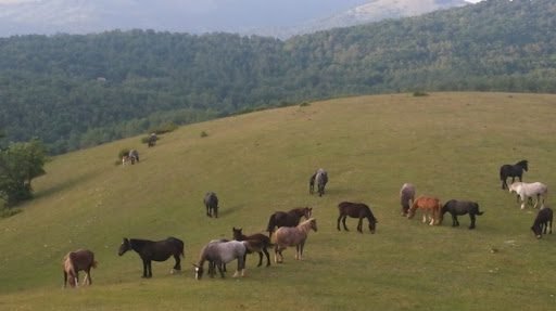
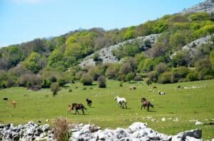
Collebertone is the grassy plateau that opens above the village of Polino, in the province of Terni, at an elevation of around 1,200 meters, within the territory of the smallest municipality in Umbria by number of inhabitants. Polino has just over 200 residents and sits at 836 meters above sea level, on the Umbrian side of the Apennines, in that band of mountains that closes the Valnerina to the south and looks at the same time toward the Terni basin and toward the Rieti area. Anyone climbing from Polino toward Collebertone leaves behind the stone houses, the hairpin bends between dry-stone walls and the bell tower of San Michele Arcangelo, and within a few kilometers is in another landscape: high-altitude meadows, a compact beech forest covering the slopes, wooden tables, spaces for picnics and barbecues, silence. There are no ticket offices, no turnstiles, no cash desk to pay at the entrance. There is a road that climbs, an informal parking spot on the grass and a natural amphitheater of beeches that, depending on the season, completely changes character. To frame the area it's worth also reading the pages on the Marmore Falls, which is about 30 kilometers away by road, and those on the Rieti-area towns that look out from the other side of the watershed, such as Leonessa and Rieti.
The old way of describing this place reduced it to two lines: an enchanting ancient forest, lovely meadows, an equipped area for picnics and barbecues, seven kilometers of mountain trails that lead from the plateau back to the village, hornbeams, Turkey oaks, mountain maples and rowans along the way, and the remote chance of crossing paths with a pine marten, a wildcat or a sparrowhawk. All true, and all much more interesting than it sounds in that compressed form. Because Collebertone lies inside a piece of the Apennines that has a documented mining history, a geology that appears in university petrology textbooks, a village that was a border fortress between two states and even the seat of a mint, an astronomical observatory that discovered an asteroid and that is now closed, and a river, the Nera, that gave its name to a regional park and that feeds the tallest artificial waterfall in Europe. It's worth telling it in full.
Where Collebertone is and how to really get there
The first thing to clarify is the geography, because the name is misleading. Collebertone is not a town, it's not a hamlet and it has no registry office: it's a place, a hill and the grassy saddle that goes with it, in the municipal territory of Polino. When you read that name next to the name of the town, you are in fact reading an address: the Collebertone plateau, municipality of Polino, province of Terni, Umbria. The spot lies on the ridge that separates the Nera basin from the Velino one, that is, on the line that for centuries divided two different administrative worlds and that still today divides Umbria from Lazio a few kilometers away.
By car from Rome and from Terni
The simplest route from Rome goes along the A1 motorway to Orte, then along the motorway link that leads to Terni. From Terni you take the Valnerina road in the direction of Arrone and Ferentillo, go up the Nera valley for about 20 kilometers and at Arrone take the turnoff that climbs toward Polino. From there the municipal road keeps climbing to the plateau. The total from Rome is around 140 kilometers and the real travel time, with normal weekend traffic, exceeds two hours. From Terni the distance is much shorter, about 30 kilometers, but the time doesn't drop below 40 minutes because the last stretch is all curves.
The point no map describes well is precisely this last stretch. The climb from Arrone to Polino and then from Polino to Collebertone is a narrow mountain road, with tight hairpins, low guardrails and very few places where two wide cars can pass each other comfortably. Anyone driving a camper or a bulky car would do well to think about it beforehand. Anyone driving in winter has to allow for ice on the shaded stretches and snow on the plateau: snowfall here is normal, not exceptional, and the road to the hill can be impassable for days. Nobody posts a sign in the valley to warn you, so a phone call to the Municipality of Polino before leaving in the cold season is the move that saves a pointless trip.
By train and public transportation
The reference railway stop is Terni, on the line connecting Rome to Ancona through Orte and the Nera valley. From Terni leave the intercity bus services that go up the Valnerina and serve the towns of the valley. It must be said frankly that these connections are designed for residents, with runs concentrated in school and work hours, and that the last uphill stretch to the plateau is not covered by any scheduled service. Anyone who wants to reach Collebertone without a car has to allow for a ride, a taxi from Terni or a long uphill walk from the valley floor. Bus schedules change every year and vary between the school period and the summer: they must be checked with the service operator before organizing the day, because a missed run in the mountains means being stuck on foot until the next morning.
Where to leave the car
There is no paved parking lot with marked spaces. There are grassy and dirt clearings along the road and near the equipped area, and the unwritten rule is the one of every mountain area: you pull over without blocking the passage of service vehicles and without encroaching on the mown meadows, which often belong to private owners or are subject to civic use. On August weekends and holidays the plateau fills with families from Terni and Rieti with grills and small tables, and finding a spot after 10 in the morning becomes complicated. Arriving early solves the problem better than any strategy.
What Collebertone really is: an equipped plateau, not a tourist resort
Honesty is needed here, because the confusion is frequent. Collebertone is often cited as if it were a ski resort of the Umbrian Apennines. In reality what the visitor finds is a high-altitude plateau with meadows, beech forest, tables, fire spots and a very wide view. The small winter facilities of the central Apennines have had mixed fortunes over the last decades, with periods of activity, long suspensions and partial reopenings tied to snow cover and to the availability of operators. It is not correct, and above all not useful to the reader, to claim that ski lifts operate here, that there is a scheduled snowmaking service, that there is a ticket office with seasonal rates or that the slopes are groomed regularly. Anyone who wants to ski in the area has to get information directly from the Municipality of Polino or from the tourist offices of the Valnerina, with a phone call and not an online search, because the information circulating online on this kind of facility is almost always years out of date.
What does always work, because it depends on no operator, is the rest: the air, the forest, the meadows, the silence, the view. On a clear spring day the plateau offers a simple and complete experience, and the elevation alone is enough to change the climate compared with the Terni basin. When Terni goes above 35 degrees Celsius, up here the temperature drops by quite a few points and the shade of the beech forest does the rest. This is, historically, the reason why families from the province come up here in August: not the facilities, but the temperature difference.
The equipped area and its rules
The picnic area is the main reason most people come up to Collebertone. Wooden tables, benches, spaces dedicated to cooking on embers. The rules are those of every Italian mountain area and deserve to be recalled, because breaking them causes permanent damage. Fire is lit only in the equipped spots and never on the grass or under the tree canopy. In the periods of highest wildfire risk the regional authorities issue ordinances that ban lighting open-air fires altogether, and those ordinances apply even where masonry braziers exist. The start and end dates of the risk period change every year and are published by the Region: checking them before loading the charcoal into the car avoids a heavy fine and, above all, avoids setting a beech forest on fire.
The second rule concerns trash: you take away everything you brought up, extinguished embers included. The third concerns animals, and a dog on a leash in an area where cattle graze and where the forest hosts wildlife is not a bureaucratic formality.

The beech forest, the meadows and what you see while walking
The forest covering these slopes is a good-quality high-altitude beech forest, with specimens of remarkable size in the stretches that have been cut least in recent decades. The beech, at our latitudes, forms compact stands above 1,000 meters and creates an environment recognizable even to untrained eyes: gray, smooth trunks, dense canopies that in midsummer let little light through, an understory poor in shrubs and rich instead in a litter of leaves that crunches under your shoes. The silence of a mature beech forest on a windless day is something you remember.
Going down in elevation, or in the more exposed and sunny stretches, the composition changes. Hop hornbeam, Turkey oak, mountain maple and rowan appear, the last of which bears showy red fruit at the end of summer. This alternation between pure beech forest and mixed woods is typical of the transitional altitude band and makes the walk more varied than you'd expect: you cross stretches of closed forest, then grassy clearings, then patches of pasture, then forest again. Botanists attribute high value to this area precisely for the richness of its plant features, and the sentence that appeared in the old description, the one about the high merit of the botanical features, was correct even if written in the language of a technical report.
The wildlife you might cross paths with
We talk about animals in the conditional, because with wildlife the conditional is the only honest form. The woods of the area host mammals and raptors that appear in the faunal lists of the Nera protected area. The pine marten is an arboreal, nocturnal and shy mustelid: its presence in these woods is documented, while a daytime sighting by a hiker is a rare event. The wildcat is even more elusive and is frequently confused with feral domestic cats, so much so that serious surveys are done with camera traps and not by eye. The sparrowhawk, on the other hand, you do get to see: it's a raptor of modest size, adapted to flying among the trunks, and its quick pass along a clearing is a show of a few seconds. In the skies above the meadows you more often notice the buzzard and the kestrel, the latter recognizable for its ability to hang motionless in the air beating its wings.
At the edge of the forest, at dawn and dusk, you can see roe deer, which have returned in numbers throughout the central Apennines, while the wild boar leaves evident traces in the turned-over ground. The wolf too is present on the Apennine ridge, but an encounter is so unlikely that citing it as an attraction would be wrong: the leash rule comes partly from here.
The route to the village
The traditional description speaks of about seven kilometers of walking between the plateau and the village through the forest and the pastures. An important clarification is needed on this, and it counts as a general warning: hiking signage in this area exists but is not uniform, and the network of numbered trails in the Umbrian Apennines has undergone uneven maintenance over the years. Before relying on a route it's best to get up-to-date mapping, verify the state of the path with the Municipality or with the local sections of the Club Alpino Italiano, and consider the season. After a windy season, fallen trees can block stretches of trail for months, and cell phone coverage in the forest is patchy. Anyone who doesn't know the area would do well to stick to short, clearly visible itineraries, without inventing crossings.
A curiosity about Collebertone - Polino (TR)
The most solid curiosity of this territory is not about the forest and not even about the village: it's about the stones. In the municipality of Polino there crops out a small volcanic complex that petrologists have studied for decades and that appears in the international scientific literature under the name of the town. The rocks found here belong to a very rare family, the kamafugites, that is, ultra-alkaline, silica-poor lavas that are known in very few places on the whole planet. The other Italian occurrences are at San Venanzo, also in the province of Terni, and at Cupaello, in the Rieti area: three points a short distance from one another that form what geologists call the intramontane ultra-alkaline province of central Italy. Outside Italy, comparable rocks are found mainly in the eastern branch of the African Rift Valley, in Uganda, which is where the name of the family itself comes from.
The point of it all, translated out of the language of the manuals, is this: beneath these limestone mountains, in an epoch geologically very recent compared with the history of the Earth, magmatic material rose with an anomalous chemical composition, different from that of the Lazio volcanoes everyone knows, from the Colli Albani to Lake Bolsena. There is no cone, no spectacular crater, nothing that resembles a textbook-illustration volcano. There is a modest outcrop which, however, for anyone concerned with how magmas form in the Earth's mantle, is worth as much as a monument. Students and researchers from Italian and foreign universities come here on educational field trips, and for the town that grayish stone is a title of scientific nobility that no tourist brochure has ever managed to explain well.
Anyone who wants to look for the outcrops on their own needs to know two things. The first is that they are on land that has owners, and that collecting samples in areas of scientific interest or inside a protected area is subject to precise limits: the geologist's hammer is not to be used at will. The second is that without competent accompaniment you risk looking at a rock without understanding what you're looking at. Over time the Municipality of Polino has set up an educational route dedicated to the geology of the Apennines, and it is to that kind of initiative, checking its hours on site, that you should turn.
Rocca di Polino, the 17th-century fountain and the smallest village in Umbria
The town that gives Collebertone its name deserves more than the five minutes it is usually granted. Polino began as a fortified settlement of the medieval age, tied in local tradition to the family from which it takes its name, and grew for a strategic reason written in its geography: it sits on a border ridge. For centuries this line separated the papal possessions from those of the Kingdom of Naples, and a village perched on a border ridge, with mines in its territory, is worth far more than its size suggests.
The Rocca dominates the village from a spur of rock. The structure has a polygonal plan and keeps two cylindrical towers, and the double ring of walls that surrounded the old core is still legible in places. Fortifications of this type, in the Umbrian Apennines, were remodeled several times between the 15th and 16th centuries to adapt them to firearms: the cylindrical bastions served precisely to deflect artillery fire, something the square medieval towers did not do. Looking at the Rocca knowing this changes how you read the building: those curves are not an aesthetic whim but a technical answer to a ballistic problem.
The monumental fountain
In the center of the town is a monumental 17th-century fountain, built at the wish of the Castelli family, which held a governing role here. It is a late Mannerist work, with lion heads and sculpted mythological figures, fed by the mountain's springs. The contrast between the scale of the work and the scale of the town strikes anyone who arrives in the square: a fountain of that kind would fit without looking out of place in a much bigger city. It is the signature a powerful family left on the place it administered, and in this case it has outlived all of those who commissioned it.
The church of San Michele Arcangelo
The parish church is dedicated to San Michele Arcangelo, a very widespread dedication in the central Apennines and tied to Lombard devotion, which arrived here with the duchy of Spoleto. The building keeps 17th-century elements and has been the subject of restorations. Inside is a plaque recalling the donation of relics of Saint Valentine by a Cardinal Orsini to the Castelli family: a detail that links this tiny mountain village directly to the patron saint of Terni, the city you can see at the bottom of the valley on clear days. The opening hours of a parish church in a municipality of 200 inhabitants follow the availability of the parish priest: anyone who wants to go in does well to ask in town instead of showing up hoping for luck.
The demographic record
Polino is the least populous municipality in Umbria. It is a record that in Italy almost always comes with the same dynamics: mountain depopulation that began after the Second World War, closure of the extraction and forestry activities that provided work, emigration to Terni and to the industrial north, a high average age. Anyone arriving in town on a Tuesday morning in November finds four people in the square and the bar closed. Anyone arriving at Ferragosto finds the town full, because the children and grandchildren of the residents come back. This double face is the reality of hundreds of Apennine municipalities and it's worth knowing before forming hasty judgments about the vitality of the place.
Something nobody tells you about Collebertone - Polino (TR)
An astronomical observatory that discovered an asteroid operated in this municipality. It's not a figure of speech: the Polino observatory received its own identification code from the Minor Planet Center, the international body that assigns codes to the facilities that carry out observations of minor bodies of the solar system. The facility was active between the end of the 20th century and the early 2000s and is credited with the discovery of a main-belt asteroid, in November 1999, later named after a person tied to the story.
The reason an observatory ends up up here is the same one for which amateur astronomers from half of Italy chase the mountains: the sky. At 1,200 meters, far from the lights of the Terni basin and the plain, with the horizon open toward the south, light pollution is much lower than in any valley-floor location. On nights without moon and without humidity the Milky Way is visible to the naked eye as a continuous band, something that in Italian cities has not happened for decades.
The part that is rarely told is what came next. The available sources indicate an indefinite closure for the observatory. It's not a sad story in the strict sense, it's the ordinary story of many small Italian scientific facilities, born from the enthusiasm of a group of enthusiasts and from an initial public grant, and then left without the recurring resources for maintenance and staff. Anyone going up to Collebertone hoping to find an open dome and a telescope ready is in for a disappointment. Anyone going up knowing that here, for a few years, someone really did point an instrument at the sky and found a celestial body that nobody had cataloged before looks at those same stars with a different eye. Before planning any observation activity it's best to ask the Municipality whether evenings organized by astronomy associations are planned, which in the Apennines happens fairly often during the summer.
The advice I give you for visiting Collebertone - Polino (TR)
The advice is to reverse the order in which almost everyone approaches this outing. The usual sequence is: you go straight up to the plateau, eat, take a short stroll in the meadow, go back down and head home. The town remains a sign passed in the car. Doing it this way you lose more than half of the place.
The sequence that works is the opposite. You arrive in Polino early in the morning, leave the car at the entrance to the town and give an hour to the village: the square with the fountain, the loop under the walls, the climb toward the Rocca, the church if it's open, a couple of words with whoever you meet, which in a municipality of 200 inhabitants is still a normal way of getting information. Then you get back in the car and go up to the plateau, arriving when the light has already warmed the meadows but before the midday wave. You walk an hour or two in the forest, return to the equipped area, eat without hurry. In the early afternoon, instead of heading straight back to the motorway, you go down into the Valnerina and devote the rest of the day to the Marmore Falls, keeping in mind that the water releases follow set schedules and need to be checked in advance.
What to put in your backpack
Water, and more than seems necessary: on the plateau there are no guaranteed drinking fountains and in summer dehydration arrives sooner than you think, because dry mountain air is deceptive. Shoes with a lugged sole, because the grassy ground going downhill is slippery and the ground under the beech forest stays damp even when everything in town is dry. An extra layer, always, even in August: the difference between the sun in the meadow and the shade in the forest easily exceeds 10 degrees Celsius, and an afternoon summer thunderstorm in the Apennines drops the temperature suddenly. A bag to carry your trash back down. Cash, because in the businesses of a small mountain municipality electronic payment doesn't always work when the data line is missing. A spare battery or power bank for your phone, since the constant search for a signal drains batteries at double speed.
What not to do
Don't trust the navigator blindly for the last stretch: forest roads and service tracks appear on maps as normal roads and lead where you don't want to go. Don't light fires outside the equipped spots and don't light any at all in the ban periods. Don't park on mown meadows. Don't leave food on the tables when you walk away, because corvids and foxes learn fast. Don't set out on the trail to the town in the late afternoon in October counting on arriving in daylight: in the mountains darkness under a beech forest arrives much earlier than on the plain.

The charcoal burners' sites, the iron and the Cava dell'Oro
Walking in the forest, with a minimum of attention, you notice in the ground some perfectly flat circular platforms, a few meters wide, often set against the slope and held by a dry-stone wall. These are the remains of the clearings for the charcoal kilns, and they are the most eloquent document of what this mountain was before it became a destination for the Sunday picnic.
The charcoal kiln was a long and laborious process. The charcoal burner stacked the wood in a concentric dome around a central chimney, covered everything with earth and leaves and lit the fire from the top, letting the wood burn slowly with very little air for entire days. The result was charcoal, which weighed much less than the starting wood and made transport down to the valley by mule economical. The charcoal burner couldn't leave: the kiln had to be watched constantly, day and night, because a collapse of the covering meant losing the whole batch. That's why in the Apennine woods there were brushwood huts next to the clearings, and why entire families spent weeks in the mountains.
This activity was widespread throughout the area that today corresponds to the Nera River Park, and it shaped the forest we see. A beech forest exploited as coppice for charcoal has a different structure from a beech forest left to grow: multiple shoots from the same stump, regular cutting rotations, trees of uniform age. When the charcoal kilns were abandoned, over the course of the 20th century, the forest began to age again, and that's why today you find specimens of respectable size where 70 years ago cutting happened every two decades. The landscape the visitor judges wild is in reality the result of the abandonment of a productive activity.
The iron, the marble and the silver
The territory of Polino had mineral resources that historical sources describe as considerable and that included marble, iron and silver. Today those deposits are exhausted, but their existence explains the town's history better than anything else. A mountain village with mines on its own territory and a border position between two states is not just any village: it is an asset. Local sources say that coins were struck here, which, if confirmed, places Polino in a very small category of tiny Apennine towns. A border mint, fed by metals extracted on the spot, is exactly the kind of activity that makes sense of a Rocca so solid and a family able to afford a Mannerist fountain.
The Cava dell'Oro
Among the mining sites of the territory is a place with an evocative name, the Cava dell'Oro. The name should be taken for what it is, that is, a traditional designation: in the Italian Apennines, place names that recall gold refer far more often to minerals with golden reflections, such as pyrite, than to real gold deposits. What matters, beyond the name, is that a mining tunnel in the area is visitable and that it represents one of the few Umbrian cases where a historical extraction activity has been turned into a visitor route. The access terms, the hours and the need to book depend on local organization and must be checked directly with the Municipality of Polino before going up: a tunnel is not a museum with a ticket office always open, and entry is with an escort.
Anyone interested in the industrial and mining archaeology of the area will also find material in Museo di Arte e Giacimenti Minerari, and more generally in the network of mining museums of central Italy, a vein that in Umbria and Lazio preserves little-visited and very instructive testimonies.
Another well-known fact, yet rarely cited
The Cascata delle Marmore, which is a short distance from here and which almost everyone visits on the same day, is artificial. It's a very well-known fact, repeated everywhere, and yet rarely does anyone explain what it really implies, and above all rarely is it connected to mountains like these.
The story begins in 271 BC, when the Roman consul Manius Curius Dentatus had a channel dug to drain the stagnant waters of the Rieti plain and send them toward the natural drop, making them plunge into the Nera. The result, expanded and corrected several times over the centuries, is today the tallest artificial waterfall in Europe, with a total drop of 165 meters spread over three tiers. It's a hydraulic work more than 2,200 years old that still works.
The rarely cited part is the practical consequence: the waterfall doesn't always flow. The system is regulated and the water is released at set times, because the same flow feeds hydroelectric plants. A sound signal announces the opening of the sluice gates and within a few minutes the flow increases spectacularly. Anyone arriving outside the hours finds a wall of wet rock and a trickle of water. The schedules change from season to season and must be checked before leaving: it's the most common mistake among people visiting this part of Umbria for the first time.
The link with Collebertone is direct. The water that makes the show possible comes down from the mountain basins of the area, and the mountains you see from the plateau are part of the same hydrographic system. The Nera rises in the Sibillini, crosses the Valnerina, picks up the Velino at the Marmore and continues toward the Tiber. Looking at the valley from above knowing this means understanding why first hydroelectric industry and then Terni's chemical and steel industry settled here: the energy of water, before electric current arrived, was the only energy available in quantity.
The right photo to take at Collebertone - Polino (TR)
The photo almost everyone takes is the one of the meadow with the tables and the forest in the background, at high noon, with the sun directly overhead. It's the worst possible hour and the result is always the same: flat green, washed-out sky, no depth.
The photo worth taking home is another one, and it's done at two moments. The first is the first hour after dawn on a clear day in late October or early November, when the beech forest turns to copper and yellow and the low light enters between the trunks from the east. In those conditions the beech wood becomes a succession of gray columns lit from the side on a carpet of glowing leaves, and the photo is made inside the forest, not from the meadow: you stand among the trunks, lower the lens to the height of the understory and let the columns in succession create the depth.
The second moment is a winter late afternoon, after a snowfall, from the edge of the plateau that looks toward the valley. With the grass covered and the beeches bare, the contrast between the white and the black branches produces almost graphic images, and the low January light lasts a long time. For this second photo the usual warning applies: if the road is snowy, the photo isn't worth the risk, and nobody up here will come quickly to pull your car out.
The viewpoint
From the plateau and from the edges of the pastures the view opens toward the Valnerina on one side and toward the Rieti basin on the other. On late-winter days, the ones when the north wind clears the air, visibility reaches far and you can recognize the outlines of the Rieti-area peaks. It's the ideal condition for a photo of overlapping ridges, the kind of image in which each row of mountains looks paler than the previous one because of the haze. With a moderate telephoto lens the result is much more effective than with a wide-angle, because perspective compression accentuates precisely the overlapping of the planes.
The portrait in town
The third photograph, the one nobody takes, is the 17th-century fountain of Polino framed from below with the town behind it. The lion heads and the sculpted figures hold up well in the side light of the morning, and the juxtaposition between the monumental scale of the work and the modest houses around it tells the whole story of the town in a single frame. An obvious but necessary recommendation: if people appear in the frame, in a village of 200 inhabitants you ask permission, and the answer is almost always yes.
Some important events that took place here in history
The history of a municipality of 200 inhabitants doesn't fill the textbooks, but what has passed through here over the centuries is denser than its size would lead you to suppose. It's worth lining it up, distinguishing what the sources document with certainty from what belongs to local tradition.
The Lombard age and the duchy of Spoleto
This whole Apennine band fell within the orbit of the duchy of Spoleto, one of the great territorial divisions of the Lombards in Italy. The dedication of the parish church to San Michele Arcangelo is the clearest sign of that period: the cult of Michael was adopted by the Lombards as a dynastic and warrior devotion, and its spread along the mountains of central and southern Italy follows almost step by step the geography of their rule. When you find a parish church dedicated to San Michele in an Apennine town, the probability that there is an early medieval root behind it is high.
The birth of the castle
The fortified settlement took shape in the medieval age. Local tradition ties the foundation to a family that supposedly gave the place its name, and regional tourism sources indicate the 12th century as the moment of origin. From then on the village functions as the stronghold of several feudal lords, changing hands more than once, as happened to every border castle in those centuries.
The frontier between two states
The fact that determined the history of Polino more than any other is its position on the border line between the Papal States and the Kingdom of Naples. A border, in the pre-unification world, was not an abstract line: it was customs, smuggling, differences in currency, weights, criminal jurisdiction. A castle placed on that line, with mines in its territory, had a military and economic value out of proportion to its population. From this come the solidity of the Rocca, the double ring of walls, and the presence of ruling families with enough resources to commission monumental works.
The 16th and 17th centuries
In the 16th century the Rocca took on the configuration it keeps today, with cylindrical bastions designed to resist artillery. In the 17th century came the season of the Castelli family, to which the town's monumental fountain is owed, dated by the sources to 1615, and to which the donation of relics of Saint Valentine recalled by the plaque in the church is also tied. It is the moment of the village's greatest relative splendor, the one in which a small mountain town allowed itself art patronage at an urban level.
The 19th century and the end of the mines
With Italian unification the border disappears and with it the strategic reason for the settlement. The extraction activities continue as long as the deposits remain economically worthwhile, then run out. The forest keeps providing work through cutting and charcoal kilns, but that cycle too goes into crisis over the course of the 20th century, when charcoal is replaced by other fuels in kitchens and industries.
The war and the free zone of 1944
In March 1944, in the territories between Arrone, Cascia and Leonessa, that is, in the mountain band of which Polino is part, there was constituted what is remembered as the first free zone of Italy: an area removed from German and Fascist control and administered by the partisan formations before the arrival of the Allies. It is a page of history that occupies in national memory much less space than it deserves, and that these woods and these ridges made materially possible: a geography of beech forests, passes and trails is exactly the terrain in which a partisan formation can move and a motorized unit cannot. Anyone walking these slopes today for leisure follows the same passages that 80 years ago served to move without being seen.
Depopulation and protected areas
The second postwar period brings emigration. Families go down to Terni, where industry absorbs labor, or go farther away. The town empties and becomes the least populous municipality in the region. In the 1990s the Umbria Region establishes the Nera River Park, a protected area of about 2,200 hectares that extends from Ferentillo to the Cascata delle Marmore and that includes the stretch of valley below these mountains. It is the moment when the territory changes function: from a productive area to an area of protection and enjoyment.
The earthquakes
The Valnerina is seismic land. The 1979 earthquake, with its epicenter in the valley, and the Umbria-Marche one of 1997 left heavy marks on the building stock of the whole area, and the 2016 sequence in central Italy hit the neighboring towns hard. Many restorations that the visitor sees are the consequence of those events. It's useful to know this also for a practical reason: in these municipalities you may find a historic building closed for works, and it isn't poor service but a structural necessity.
Americo Matteucci
In the town's memory appears the figure of Americo Matteucci, remembered for a term as mayor that lasted 47 years. It's a fact that by itself tells the nature of small Italian mountain municipalities, where administrative continuity is measured in decades and where one person can coincide with the recent history of an entire community.
Who has passed through Collebertone - Polino (TR)
An honest list must distinguish between those who passed through here with documentary certainty and those who crossed this territory in a broader sense. We start with the latter.
Manius Curius Dentatus
The Roman consul who in 271 BC had the channel dug at the Marmore worked about 20 kilometers from here, and his work has determined the hydraulic layout of this whole part of Umbria up to today. There is no record that he climbed these mountains, but the valley you observe from the plateau is the valley he modified.
The Lombards of the duchy of Spoleto
The cult of San Michele in the town church is their imprint. Apennine passes like this one were the routes by which a duchy stretching from the Adriatic to the ridge was held together, and the ridges were roads, not obstacles.
The feudal lords, the Castelli and Cardinal Orsini
The families that governed the village left physical traces: the Rocca, the fountain, the plaque with the donation of the relics of Saint Valentine attributed to a Cardinal Orsini. The Orsini are one of the great houses of the Roman aristocracy, and their appearance in a mountain church with 200 parishioners shows how much these lands were inside the power networks of papal Rome, and not on the margins.
The charcoal burners and the miners
They are the real protagonists of this mountain, and they have no names in the books. Generations of men and women spent entire seasons in the forest watching over charcoal kilns and in the tunnel extracting iron, marble and silver. The circular platforms in the understory are their archive. When you walk in the Collebertone beech forest you walk in a workplace, not in a virgin forest, and this is the thing that changes most how you look at it.
The partisans of the Valnerina
The formations that in 1944 constituted the free zone between Arrone, Cascia and Leonessa moved on these ridges and in these woods. The plateau, the passes and the trails that today serve to reach a picnic table were for months a logistics network.
Geologists and astronomers
The latest arrivals are the most unexpected. On one side the petrologists, Italian and foreign, who come to study the ultra-alkaline rocks of the territory and who have made the name of this municipality an entry in the international scientific literature. On the other the amateur astronomers who kept an observatory running up here for a few years and who identified an asteroid. Two very small communities, both arrived for the same reason: what is under your feet and what is above your head, in a place where neither is disturbed by the city.
When to go to Polino (TR) and when to avoid the climb
Seasonality matters more here than elsewhere, because elevation amplifies everything. It's worth going through it month by month, without promising conditions that nobody can guarantee.
Spring
Between April and June the plateau is at its best. The snow has withdrawn, the meadows turn green again, the beech forest puts out new leaves of a very pale, translucent green, and temperatures stay pleasant even at noon. May and the first half of June are the ideal period for walking, because the heat doesn't weigh and crowding is still minimal. The only drawback is instability: late-spring afternoon thunderstorms in the Apennines arrive with little warning and must be taken seriously, especially if you're on an open ridge.
Summer
July and August are the months of peak attendance. The reason is simple: when the Terni basin becomes a furnace, this band of mountains offers an alternative half an hour away by car. On weekends and holidays the equipped area fills up early. Anyone looking for quiet comes up on a weekday or arrives very early and leaves in the early afternoon. In summer the fire rules apply with greater force, because it's the period when the regional bans kick in.
Autumn
October and November are, from a photographic and sensory point of view, the most beautiful moment of the year. The beech forest changes color spectacularly, the air turns crisp, the forest empties of people and fills with sounds. It's also the season when you have to pay attention to short days and to fog, which in the Apennines rises from the valley floor in the afternoon and erases landmarks in a few minutes. The hunting season must also be kept in mind, which in Italian woods affects certain days of the week: finding out in town which are the hunting days is a reasonable precaution before heading into the forest with a dog.
Winter
Snowfall up here is normal and can be heavy. The snow-covered landscape of the beech forest is magnificent, and access is another matter entirely. The climbing road can be closed or impassable, ice on the shaded stretches stays for days, there are no services at elevation and assistance in case of trouble arrives from the valley on mountain time. The winter equipment required by law on the affected road stretches must be respected, and anyone without experience driving on snow would do well to give up. On winter sports, what was said above applies: before going up with skis in the trunk you need a direct check on the actual state of any services, which cannot be taken for granted.
What's around Collebertone
The plateau works very well as one piece of a broader itinerary, because it sits at the center of an area that in a handful of kilometers passes from Umbria to Lazio and from a river valley to an Apennine basin.
Toward the Valnerina and Terni
The most obvious destination is the Marmore Falls, reached by going down into the valley and climbing back toward Terni: a 165-meter drop on three tiers, two viewpoints connected by equipped trails, and the absolute need to check the water release schedules before showing up. Staying in Umbria, anyone wanting to venture farther north will find Orvieto, which belongs to the same province though it lies on the other side of the territory, and toward the upper valley you reach Norcia and Cascia, the two towns that close the Valnerina toward the Sibillini.
Toward the Rieti area
On the other side of the watershed you enter Lazio and the Rieti basin opens up. Leonessa is the mountain town closest in character and elevation, with its arcaded square and its winter vocation. Terminillo has been the Romans' reference mountain for a century. Rieti is the provincial capital, with the historic center on the Velino, the same river that ends at the Marmore. On the Franciscan side are the Greccio Sanctuary, where in 1223 the nativity scene everyone knows was set up, and the Poggio Bustone Sanctuary, above the town of the same name.
Other villages and natural areas of the Rieti area
Anyone with time for a longer loop will find Antrodoco at the narrows of the gorges, Borgo Velino and Contigliano in the plain, Poggio Bustone on the sunny side. For hiking at elevation there are the Montagne della Duchessa Nature Reserve and the Monte Navegna and Monte Cervia Nature Reserve. Farther north, on the border with Marche and Abruzzo, are Amatrice and Accumoli.
A comparison for beech forest lovers
For anyone who truly likes beech woods, I point to a point of comparison found in a completely different area, in the Viterbo province, which deserves a trip of its own: the Oriolo Romano beech forest, a depressed beech forest that grows at a much lower elevation than normal, in the Sabatini Mountains. Comparing a high-altitude beech forest like Collebertone's with a hill-plain beech forest like the one at Oriolo helps you understand how sensitive the beech is to local conditions of humidity and temperature.
Quick questions about Collebertone and Polino (TR)
Do you pay to enter Collebertone?
No. The plateau and the equipped area are freely accessible and there is no entrance ticket. Any costs concern only private services that may happen to be open.
Are there working ski lifts?
It can't be claimed. The small Apennine winter facilities operate intermittently and in many cases are suspended. Before counting on a lift, on groomed slopes or on a rental service, you need a direct check with the Municipality of Polino or with the area's tourist offices.
How far is Collebertone from Terni?
About 30 kilometers by road, but with the last stretch all uphill and in hairpins: the real travel time exceeds 40 minutes.
Can you get there without a car?
With difficulty. The rail reference is Terni and the intercity buses serve the Valnerina, but the last stretch at elevation has no scheduled connections. You need a ride, a taxi or a long climb on foot.
Can you light a fire for a barbecue?
Only in the equipped spots and only outside the ban periods set by the regional ordinances against wildfires, which change every year. When in doubt, ask at the Municipality.
Are there bars or restaurants at elevation?
You can't count on anything being open continuously on the plateau. Food businesses are in town and in the towns of the Valnerina, with seasonal hours and openings. It's best to come up with lunch already prepared.
Is it suitable for children?
Very. The meadows are wide and flat, the distances short, and the forest is within stroller reach on the easy stretches. The things to watch are the summer sun on the open meadow, the temperature dropping fast in the afternoon and the access road, which doesn't forgive distraction.
Is there drinking water?
It's not guaranteed. Mountain fountains may be closed or not potable depending on the period and on health checks. You come up with water in your backpack.
Does the phone get a signal?
In patches. On the open plateau coverage is generally acceptable, inside the beech forest and in the ravines it becomes patchy. An itinerary planned before leaving is worth more than any app.
How much time do you need for a full visit?
A whole day if you want to combine the village, the plateau and a walk in the forest. Half a day only for the picnic and a short loop. Two days if you add the Valnerina and the Cascata delle Marmore at an easy pace.
Collebertone is worth precisely for what it doesn't have. It has no lifts to rely on, no services at elevation, no impeccable hiking signage and no infrastructure designed for mass tourism. It has a serious beech forest, real meadows, an elevation that in summer changes the day, a tiny village with a Rocca and a fountain that tell a story of borders, mines and power, and under your feet rocks that scientists come to study from half the world. Anyone coming up here expecting a tourist resort will go down disappointed. Anyone coming up to walk, eat outdoors, look at a forest and understand a territory will find one of the most honest days this part of Italy knows how to offer. The final recommendation remains a single one: call first, because in the mountains the information that counts is not found online but at the Municipality.
Frequently asked questions about Collebertone, Polino (TR)
What is Collebertone?
Collebertone is a high-altitude plateau in the municipal territory of Polino, in the province of Terni, with meadows, beech forest, tables and fire spots, and not a tourist resort or a real ski resort as it is sometimes described. The small winter facilities of the central Apennines have had mixed fortunes over recent decades.
Where exactly is Collebertone?
Collebertone is in the municipality of Polino, in the province of Terni, in Umbria: it is not a town or a hamlet, but a hill and the grassy saddle that goes with it. The name, placed next to that of Polino, in fact indicates an address: the Collebertone plateau, municipality of Polino.
Do you pay to enter Collebertone?
No, the Collebertone plateau and its equipped area are freely accessible and there is no entrance ticket. Any costs concern only private services that may be open on site, not access to the plateau itself.
Are there working ski facilities at Collebertone?
It can't be claimed with certainty. The small Apennine winter facilities near Collebertone have operated intermittently and in many cases been suspended in recent decades, so it's best to get information before counting on active ski lifts.
Why is Polino famous among geologists?
In the municipality of Polino, where Collebertone is located, there crops out a small volcanic complex studied by petrologists for decades, which appears in the international scientific literature under the name of the town. The rocks present here belong to the kamafugites, ultra-alkaline, silica-poor lavas that are extremely rare worldwide.
When is the best time to go to Collebertone?
Spring, between April and June, is when the Collebertone plateau is at its best: the snow has withdrawn, the meadows turn green again, the beech forest puts out new leaves and temperatures stay pleasant even at noon. May is indicated as the full month for the blooming of the meadows.
What is near Collebertone?
Near Collebertone, going down toward the Valnerina and Terni, is the Cascata delle Marmore, with a 165-meter drop on three tiers. In the village of Polino, at the foot of the plateau, you can see the medieval Rocca and a 17th-century fountain.
Article written by the editorial team of TourLeaderPro, contact them for Private, Corporate and V.I.P. Tours and Experiences. To organize a day in the Valnerina and on the Terni Apennines with a licensed tour leader, start from the TourLeaderPro contacts page. Tour operators building itineraries between Umbria and the Rieti area will find the consulting service in the section dedicated to tour operators.
Planning a trip to Italy? The English guides to visiting Rome and its surroundings are at ItalyPlanner.com. For those thinking in terms of days out of the city there is the guide to the best day trips from Rome, also useful for understanding how to fit southern Umbria into a trip that starts from the capital.