Accumoli (RI)
In short. You reach Accumoli from State Road 4 Salaria, at around kilometer 142, at an elevation of 855 meters, in the province of Rieti.
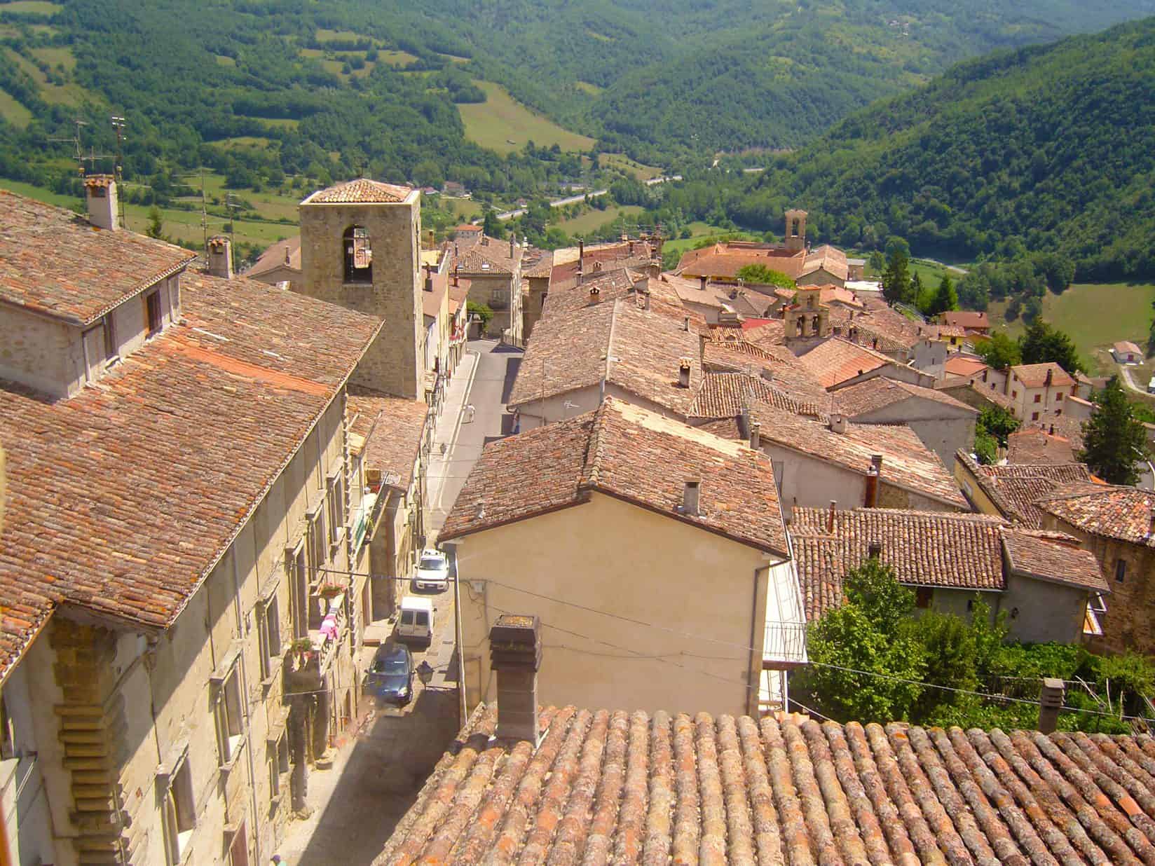
You reach Accumoli from State Road 4 Salaria, at around kilometer 142, at an elevation of 855 meters, in the province of Rieti. The town hall is at Via Salvator Tommasi 44, switchboard 0746 80435, certified email comune.accumoli@pec.it. You don't pay for any ticket because there is no paid site to visit. The main town is a village, and since August 24, 2016 its historic center has been a closed red zone, fenced off, not walkable. Anyone who arrives today sees the village from outside, from the road and from the plazas around it, and visits instead the hamlets, the trails of the Laga Mountains and the monumental cemetery, partly reopened in August 2025 after nine years of closure. From Rome it is about 150 kilometers: A1 to Fiano Romano, then the Salaria toward Rieti and Amatrice. From Rieti it is a little under 70 kilometers of Salaria, a good hour of driving. There are no ticket offices, no opening hours to respect, nothing to book. What you need is to know what you are looking at, and this guide exists for that.
If the trip is part of a wider tour of the Rieti area, the page on Rieti and the one on Amatrice complete the itinerary. Accumoli alone is worth half a day, the Tronto valley is worth three.
Accumoli (RI) today: what you can see and what you can't
The first point is what many people are not told, and what needs saying right away. The main town of Accumoli can't be visited. The village, perched on the hill that overlooks the confluence of the Tronto and its tributaries, has stayed where the earthquake left it: houses still standing but unsafe, props, scaffolding, nets, and a perimeter of barriers that closes off the entire historic settlement. The red zone is not a bureaucratic formality. It is an area where collapses are possible, and where not even the owners enter without authorization and a technical escort. Anyone who arrives hoping to stroll among the noble palaces of the 16th century is left empty-handed, and you might as well know it before starting the engine.
What you can see, and what is worth the trip, is something else. You see the profile of the village from high up on the Salaria, with the Civic Tower still standing, protected by a steel cage that has held it together for 10 years. You see the hamlets, 17 or 19 depending on how you count the smaller localities, scattered over 87 square kilometers of mountain. Some are partly lived in again, others reduced to ruins, others still, like Grisciano, have started living again. You see the village of emergency housing solutions, the wooden cottages delivered starting in 2017, where most of the population still lives. And you see, above all, a mountain landscape of the first order: the Laga Mountains to the south, the Sibillini to the north, the high-altitude pastures, the pantani, the beech woods.
The verdict, in short: Accumoli is not a destination for a quick photo and a departure. Either you arrive willing to walk a few hours on the trails and to stop and eat in one of the hamlets, or you risk turning the stop into a visit to other people's grief, which is the worst thing a traveler can do in an earthquake-stricken town. Respect, here, is measured in time spent and money left in the area.
Where Accumoli (RI) is: the northernmost municipality in Lazio
The geography of Accumoli is a small administrative anomaly that explains half the history of the village. The municipality occupies the far northeastern corner of Lazio, in the upper Tronto valley, and borders Umbria to the west, the Marche to the north, Abruzzo to the southeast. It is the only municipality in Lazio that touches the Marche. Its counterpart on the Marche side, Arquata del Tronto, is in turn the only Marche municipality that touches Lazio. A border that touches at a single point, like two fingers brushing.
The municipal territory stretches between 650 and 1,800 meters of elevation or so, over an area that municipal sources put at around 87 square kilometers, with a population density among the lowest in Lazio: a few units per square kilometer. The main town is at 855 meters. The registered residents hovered around 500 before the quake and the later data remain of that order of magnitude, but the number of people actually present in winter is considerably lower.
The name, according to the most accredited etymology, comes from ad cumulum, at the peak, at the summit. The village was founded at the top of the hill that overlooks the Tronto valley and the route of the Salaria, and the place name describes exactly what you see arriving from below. It is one of those transparent etymologies that rarely deceive.
How to get to Accumoli (RI) from Rome, from Rieti and from the Marche
By car to Accumoli (RI)
The car is in practice the only reasonable means. From Rome you take the A1 toward Florence, exit at Fiano Romano and take State Road 4 Salaria. You follow it through Passo Corese, Rieti, Cittaducale, Antrodoco, then climb toward the pass and continue in the direction of Amatrice to the Accumoli turnoff. The total is about 150 kilometers and two and a half hours of real driving, not the kind the navigator promises. The Salaria beyond Rieti is a mountain state road, with stretches of one lane per direction, tunnels and curves, and on summer weekends it backs up.
From L'Aquila you go up toward Antrodoco and take the Salaria north. From San Benedetto del Tronto and the Adriatic coast you take the motorway link toward Ascoli Piceno and continue on the Salaria inland. It is about 70 kilometers, and this is the quickest access for anyone coming from the Adriatic. From Perugia you go through Norcia and come down onto the Salaria.
A practical warning worth its weight in gold: in winter the municipal roads that climb to the high hamlets, Poggio d'Api, Roccasalli, Illica, are subject to snow and ice, and the mandatory winter equipment on these roads is not a suggestion but a necessity. Anyone who goes up in December with summer tires stays stuck, and the nearest tow truck is not around the corner.
By public transportation to Accumoli (RI)
A road connection exists and is run by private bus lines serving the axis Roma Tiburtina, Rieti, Amatrice, Accumoli, Arquata del Tronto, Ascoli Piceno and Porto d'Ascoli. The runs are few and concentrated in school and work time slots. Times and tickets should be checked directly with the carrier before leaving, because the picture changes with the school calendar. The nearest useful train station is Ascoli Piceno, about 40 kilometers away, and from there you still need a bus or a taxi.
Frequently asked questions about Accumoli (RI)
Can you visit the historic center of Accumoli (RI)?
No. The historic center of Accumoli (RI) has been in the red zone since August 24, 2016, fenced off and closed because of the risk of collapse after the earthquake that had its epicenter here. There are no authorized guided routes inside it. You look at it from the outside, from the Salaria and from the surrounding plazas.
How much does it cost to visit Accumoli (RI)?
Nothing. In Accumoli (RI) there are no tickets, no museums open in the main town and no paid parking tied to an attraction, since the historic center remains closed to visitors. The only foreseeable expense is for fuel and for a possible stop in the hamlets.
How do you get to Accumoli (RI) from Rome?
From Rome you get to Accumoli (RI) by car, taking the A1 toward Florence, exiting at Fiano Romano and taking State Road 4 Salaria, which you follow through Passo Corese, Rieti, Cittaducale and Antrodoco to the Accumoli turnoff. The total is about 150 kilometers.
What do you eat in Accumoli (RI)?
The signature dish of Accumoli (RI) is pasta alla gricia, whose most widespread etymological hypothesis derives it from the name of Grisciano, a mountain hamlet of the municipality. The recipe is absolutely simple, guanciale and pecorino, pepper and pasta, ingredients that shepherds carried with them during the transhumance because they keep and weigh little.
Is Accumoli (RI) suitable for a trip with children?
Accumoli (RI) is not a destination for small children if the idea is visiting the village, which simply doesn't exist as a walkable experience. It works well instead as a base for gentle mountain outings, with the pantani trails at manageable slopes and the hunt for the Bourbon boundary markers as an orienteering game.
When is the best time to go to Accumoli (RI)?
The best time for Accumoli (RI) is the second half of June and the month of September, when the days are long, the pastures are in bloom or golden and the Salaria flows without queues. July and August work anyway, but on the central weekends traffic on the state road gets heavier.
Is Accumoli (RI) accessible to people with mobility difficulties?
The historic center of Accumoli (RI) is closed to everyone, so the question of wheelchair accessibility doesn't arise for the village proper. The accessible areas remain the plazas, the streets of the hamlets and the village of cottages, with mostly asphalt or packed-earth surfaces.
Frankly speaking: getting here without a car is possible but inconvenient, and once you arrive you are tied to the hamlet where you got off. For an organized group a coach with a driver is best, and there are professionals who know these roads for that: the network of tourist escorts of TourLeaderPro works regularly in the central Apennines and knows which vehicles get through and which don't on the hairpin bends above Grisciano.
Where do you park and where do you stop
There is no paid parking. You stop in the pull-offs along the Salaria, in the plazas of the hamlets and in the area of the temporary village, always without blocking access for construction sites and service vehicles. Here heavy construction traffic is a daily thing and a badly parked car blocks real work.
The earthquake of August 24, 2016 in Accumoli (RI)
At 03:36 in the morning on August 24, 2016, a quake of moment magnitude 6.0 had its epicenter in the territory of Accumoli, at a depth of a few kilometers. It was not a quake felt in Accumoli. It was a quake born in Accumoli. The difference is substantial and explains why a village of 500 souls paid a price that is rarely associated with such small numbers.
The victims in the municipality were 11: four in the main town and seven in the hamlets. Among them a family of four, with two children, who were caught under the collapse of the bell tower of the church of San Francesco, which fell onto the adjacent building. It is the fact that made the name of Accumoli known all over Italy in the following hours, and that even today is the first thing local people tell about themselves when they introduce themselves to a stranger.
The seismic sequence did not end that night. On October 26, 2016 two strong shocks hit the Macerata area, and on October 30 a quake of magnitude 6.5 with its epicenter in the Norcia area, the strongest recorded in Italy in almost 40 years, finished the job on what was left standing. The buildings of Accumoli that had held in August, in many cases, fell in October. On January 18, 2017 four shocks above magnitude 5 were added in the middle of winter, with deep snow, isolating the mountain hamlets for whole days.
Why the damage was so severe
Three reasons come together, and it is worth understanding them because they apply to the whole Apennines. The first is the closeness to the epicenter and the shallow depth of the hypocenter, which concentrated the energy on a small area. The second is the building type: masonry in local sandstone, often rubble-core, with wooden floors and heavy roofs rebuilt in concrete after the war, a combination that construction science knows as particularly unfavorable. The third is the historical stratification: 16th-century palaces grown by successive additions, building clusters in which each structure reacts differently to the same stress.
Accumoli already had a documented seismic history: the earthquakes of 1639 and 1703 had heavily damaged the settlement, and in both cases the village had been rebuilt on the same site, with the same materials and the same techniques. It is an Apennine constant: you rebuild where you were, because that is where the water, the fields, the church and the dead are.
The reconstruction of Accumoli (RI): where we really stand
10 years later, the situation has to be told without discounts and without exaggeration. The displaced were moved to a village of emergency housing solutions, the so-called SAE, prefabricated cottages delivered in stages starting in 2017: the first 30 were assigned that year and the total number exceeded 70 units. Those who didn't want to or couldn't stay accepted the autonomous accommodation allowance, a monthly compensation to find housing elsewhere. Many young people took that road and did not come back. In the cottages, today, mostly elderly people live.
The historic center remains at a standstill. The work completed so far mostly concerns making things safe, removing rubble, recovering and cataloguing architectural fragments, and preparing the construction sites. In February 2026 the Special Reconstruction Office of the Lazio Region ordered the urgent temporary occupation of private areas for cleaning and surveys preliminary to repairing the retaining walls of the urban roads and public spaces of the historic center. It is yet another preliminary step, necessary, and at the same time the measure of how long the game still is. Residents interviewed for the tenth anniversary talk of at least another 10 years before the village has roads, water, sewers, lighting and gas.
The public works already completed in Accumoli (RI)
Something, however, has been finished. In August 2025 the monumental cemetery of the main town partly reopened, after nine years. The work, with a total cost of 2,649,775.40 euros, included structural repairs, demolitions and reconstructions, restoration of the architectural elements, upgrading of the systems and the construction of a new cemetery church with a mortuary chamber, a caretaker's room and restrooms. Mayor Mauro Tolomei called it a very important moment for the community, and it is not municipal rhetoric. In a village where nobody can yet go back into their own home, being able to return to the grave of one's dead is the first piece of normality given back.
In the same phase, funding increases were approved for the cemetery of the hamlet of Fonte del Campo, for over 672,000 euros, for the rebuilding of tanks and springs of the municipal aqueduct, for over 258,000 euros in total, and for the Monte Calvario road, for about 187,000 euros. These are figures that tell better than any adjective what rebuilding in the mountains means: first water, then roads, then houses.
The recovery of the works of art
The movable heritage was saved through operations carried out by the heritage offices, the fire brigade and the carabinieri of the Cultural Heritage Protection Unit, whose work in these years is also told in the Historical Museum of the Carabinieri in Rome. From the churches of Santa Maria della Misericordia and of the Madonna delle Coste, canvases, statues, liturgical furnishings and fragments were extracted and moved to the equipped depots set up after the quake. For the church of San Francesco, which collapsed, an operation begun in 2023 on commission from the Special Reconstruction Office of Lazio identified, recovered, cataloged and stored every recognizable architectural fragment, cleaning the area and making it ready for construction. It is archaeologists' work, carried out on a building of a few years ago: the numbered stones wait in storage to return to their place.

The historic center of Accumoli (RI) and its palaces
What follows is the village as it was and as it will be again, stone by stone. None of these buildings is accessible today. You recognize them by their profile, by historical photographs and, for those who arrive with a guide, by the position they occupy in the urban layout. They are worth knowing, because the value of Accumoli is not scenic but architectural, and the historiography of Apennine civil architecture considers this settlement a case study.
The Civic Tower of Accumoli (RI)
Going up Via Salvator Tommasi you reach the Civic Tower, dated to the 12th century. It is wide in plan, square, slender, and it is the symbol of the ancient communal freedoms: a structure that in the whole Tronto valley has no equal in type and proportions. It withstood 2016, wounded but standing, and the metal cage that has surrounded it for years has become, in spite of itself, the most reproduced image of the village.
A detail that says a lot: the tower was not a military watchtower, but the civic bell tower of a commune that claimed its own autonomy against the bishops and the feudal lords. In the Apennines civic towers are rare, because free communes were rare. Here, in a border valley contested among Ascoli, Norcia and the Kingdom of Sicily, a community managed to give itself its own institutions and to set them in stone.
The Palazzo del Podestà of Accumoli (RI)
Joined to the left of the Civic Tower stands the Palazzo del Podestà. It is a horizontal structure, built with squared and smooth sandstone blocks, marked on the ground floor by two arches. It is the typical solution of the medieval public palaces of central Italy, with the portico open onto the square for the market and for proclamations, and the rooms of government on the upper floor. Until the quake it housed municipal offices.
The pairing of tower and palace forms a single block that is, in fact, the civic acropolis of Accumoli. Before 2016 the thing that struck most was the quality of the worked stone: Laga sandstone, cut with precision, in a mountain village that in the 13th century counted a few hundred souls. It is not a minor detail, it is proof of skilled workers and of a patron with real money.
The Palazzo del Guasto of Accumoli (RI)
The Palazzo del Guasto dates from the 15th century. Here, between 1427 and 1433, Saint Bernardino of Siena preached. The fact is recalled by the Bernardine monogram carved on one of the windows, the radiant trigram with the letters IHS that the preacher spread across half of Italy and that is found, identical in form, on the facade of Palazzo Pubblico in Siena and in dozens of buildings in Umbria and the Marche.
Bernardino traveled the central Apennines in those years preaching against usury and factions, and died in L'Aquila in 1444. That he passed through Accumoli is not oral tradition. It is attested by the sign he left, and the monogram on a private window means that the owner wanted to mark his home with the preacher's symbol. An act of devotion, and at the same time a political statement.
The Palazzo Marini of Accumoli (RI)
Palazzo Marini is the large late Mannerist structure adapted to the slope of the street. It is recognized by the portal framed in diamond-point rustication and by the twisted columns with elephant-foot Ionic capitals: a decorative repertoire of Neapolitan derivation, which arrives here because the Kingdom arrived here. Inside, before the quake, there were frescoes inspired by Neapolitan late Mannerism, coffered ceilings and a monumental fireplace.
The diamond-point rustication and the twisted columns are not a local language. They are a court language, imported by someone who had dealings with Naples and wanted the neighbors to know. In a village of 500 inhabitants, two competing portals 50 meters from each other tell of a rivalry between families that lasted centuries.
The Palazzo Cappello of Accumoli (RI)
Palazzo Cappello is the most ambitious building in the village: five floors, 17th century, at the top of the settlement near the old fortress. The 16th-century structure incorporates a part built or rebuilt at a later time, recognizable by the different building technique. The original part is entirely in exposed squared stone, with monumental windows, while the addition stands out at a glance for its more modest masonry work.
There are three entrances, two of them monumental. The one on the east side opens at cellar level and reaches the first floor with a sandstone staircase. From there you enter the palace through a wide helical stair that lets you go down to the second-level cellars or up to the main floor. This stair, built entirely on site with sandstone steps set into the wall and resting at the center following a helix, is an architectural rarity, in all probability unique in the district. A self-supporting spiral staircase in a mountain palace is an exercise in stereotomy that presupposes a stonecutter of the highest level.
The monumental entrance to the northwest was reserved for carriages. A wide passage with a round vault leads to the inner courtyard, characterized by a loggia on three orders, with sandstone columns and Corinthian capitals in the first two, while the third, built later, adopts simpler Doric capitals. From the courtyard a monumental staircase, also from a later phase, rises to the loggia.
Local tradition says that the top floor, whose interiors stayed unfinished until 1996, was built with the precise aim of taking an hour of sunset sun away from Palazzo Marini below. It is a story to be taken for what it is, oral tradition and not an archive document, but it describes exactly the social climate of a village where two families glared at each other from their respective windows.
The palace also had a second life: from 1864 it was used as a Carabinieri barracks, three years after the founding of the Italian state, which probably makes it one of the first barracks of unified Italy. Before the quake it housed a municipal natural history museum.
The Palazzo Organtini of Accumoli (RI)
Palazzo Organtini is 18th-century, on three floors, and stands out for its frescoed rooms. The coffered ceilings and the large reception hall, also decorated with paintings of the period, are notable. It is the latest of the series and the most domestic. No longer the grandiloquence of Palazzo Cappello, but the bourgeois comfort of a family that had made its money from land and livestock.
The walls, the four gates and the fortress
Accumoli had obtained the title of city during the reign of the Aragonese, and was surrounded by civic walls equipped with towers and by four gates: Porta San Pietro, Porta Vecchia, Porta del Campo and Porta Pescara. The circuit followed the ridge, and the route is still readable in the layout of the present streets. The fortress occupied the highest point, where Palazzo Cappello was later established. Four gates for a settlement of this size mean four traffic routes: toward Ascoli, toward Norcia, toward Amatrice, toward the high pastures. Accumoli was not a closed village, it was a hub.
The monument to Salvatore Tommasi
At the entrance to the village stands the monument to Salvatore Tommasi, the work of the Pitigliano architect Enrico Lattes, completed in 1927. Tommasi, born in Roccaraso in 1813 and died in Naples in 1888, was a clinician and physiologist of European standing, a patriot, a senator of the Kingdom. The main street of the village bears his name and the town hall still has its address on Via Salvator Tommasi. The monument of 1927 comes in the year in which Accumoli passed from the province of L'Aquila to that of Rieti, and it is no accident: a statue is always also a claim of identity.
The churches of Accumoli (RI)
The church of San Francesco
It was the best-known church of the village, and on August 24, 2016 the collapse of its bell tower caused the victims in the main town. The building collapsed, and for years the remains stayed under heaps of debris. In 2023 the Special Reconstruction Office of Lazio assigned the recovery work. Every recognizable architectural fragment was identified, recovered, cataloged and stored, with the involvement of the heritage office, the Diocese of Rieti and the municipal administration. The area was cleaned and made ready for construction. The fragments are kept in secure depots and are the material basis of the future reconstruction. When people say reconstruction as it was and where it was, this is what is literally meant: putting the numbered stones back in their place.
The church of Santa Maria della Misericordia
Main church of the settlement, heavily damaged. The movable works it contained, canvases, statues and liturgical furnishings, were saved through an operation carried out by the structures of the Ministry of Culture together with the fire brigade and the carabinieri specialized in heritage protection, and moved to the equipped depots set up after the quake. It is the fate of almost all the movable heritage of the crater: the works exist, they have been saved, but they are not visible to the public and will not be until there are buildings able to receive them.
The sanctuary of the Madonna delle Coste
The sanctuary of the Madonna delle Coste, just outside the settlement, is the other place of worship that defines Accumoli, the destination of the processions and marches that the community has kept organizing even after the quake. From here too the works were recovered and secured. The Marian cult, together with the dedication of the patron saint, the Blessed Virgin Mary of Sorrows, celebrated on the first or second Sunday of September, gives the measure of how much Marian devotion structures the calendar of this territory.
The monumental cemetery
The monumental cemetery of the main town is today the only historic complex of Accumoli that is partly accessible. It reopened in August 2025 after nine years, at the end of a construction project costing 2,649,775.40 euros that included structural repairs, demolitions and reconstructions, restoration of the architectural elements, upgrading of the systems and the construction of a new cemetery church with a mortuary chamber, a caretaker's lodging and restrooms. Anyone who visits Accumoli with respect passes through here, and does so in silence.
History of Accumoli (RI): a thousand years of border
The origins and the name
The name Acumulo appears perhaps for the first time in 1037, when Conrad II confirmed the donation of the Terra Summatina, made by Maginardo di Siolfo in the 10th century to the bishop of Ascoli. The commune proper originates in the 12th century, when the territory of the upper Tronto valley was under the rule of the Normans and then of the Kingdom of Naples. The impetus was defensive: Cascia threatened the far border of the Kingdom, and the local governors decided to gather under a single city the many villages scattered across the valley, in all probability replacing the declining center of Summata. It is the phenomenon historians call incastellamento by synoecism, and Accumoli is a textbook example.
Between Ascoli, Norcia and the Kingdom
In the 13th century Accumoli was long contested by Norcia, under whose rule it fell for some time, before being returned around 1255 to the bishop of Ascoli. Annexed to the Kingdom of Sicily, under the Angevins it became part of the vast district known as the Capitania della Montagna d'Abruzzo, established to guard the northernmost stretch of the border between the Kingdom of Sicily and the Papal State. The role of frontier sentinel explains everything: the walls, the four gates, the fortress, the privileges, and the fact that such a small village obtained the title of city.
From the Medici to the Bourbons
In the 15th century Accumoli was the object of exchanges between the kings of Naples and the pope, to return then to the Kingdom as a crown-land universitas until the purchase made by the Medici in 1643. It thus became part of the Medici-Farnese states, one of the most curious enclaves of the political geography of ancien régime Italy. It suffered very serious damage from the earthquakes of 1639 and 1703, two dates that in the central Apennines mark building watersheds. Much of what was seen before 2016 was post-1703 reconstruction.
From Abruzzo to Lazio
Accumoli historically belonged to Abruzzo, under the kingdoms of Sicily, of Naples, of the Two Sicilies and of Italy. It was included in turn in the Giustizierato of Abruzzo between 1265 and 1273, in Abruzzo Ulteriore between 1273 and 1806, in Abruzzo Ulteriore Secondo between 1806 and 1860, and in the province of L'Aquila between 1860 and 1927. From 1806 to 1926 it was part of the district and then of the circondario of Cittaducale. Only in 1927, with the creation of the province of Rieti, did Accumoli and Amatrice pass to Lazio. For the oldest residents this is still a subject of conversation: culturally, linguistically and gastronomically the village looks to Abruzzo and the Marche far more than to Rome.
The hamlets of Accumoli (RI): where the village goes on living
The municipality has 17 hamlets recorded by the administration, which become 19 if some smaller localities are counted separately: Cassino, Cesaventre, Colleposta, Collespada, Fonte del Campo, Grisciano, Illica, Libertino, Macchia, Macchiola, Mole, Poggio Casoli, Poggio d'Api, Roccasalli, San Giovanni, San Giovanni Vecchio, Terracino, Tino, Villanova. They are tiny clusters, distributed between 650 and 1,200 meters of elevation, connected by narrow municipal roads. Anyone who wants to understand Accumoli has to tour them, because that is where the territory is still inhabited.
Grisciano, the hamlet of the gricia
Grisciano is the liveliest hamlet and the one that gives the traveler the best food reason to climb all the way up here. The place name goes back to a certain Grisio, whom the Farfa documents recall in 745 as the owner of vast estates between Umbria and Abruzzo. The village has changed site three times. The first settlement, on the left bank of the Chiarino, was destroyed during the struggles of the 12th century. The second was largely swept away, 26 houses, by the flood of June 24, 1858 and the later floods.
The parish church of Sant'Agata was built in 1930 and preserves a fine polychrome terracotta of the 15th century attributed to a follower of Silvestro dell'Aquila, one of the major sculptors of Aragonese Abruzzo. The bells date from 1616, the work of Josef de Nursia, and from 1680. Every year, on August 18, Grisciano holds the festival of pasta alla griscia. It is the festival that more than any other has held this community together even in the worst years.
Poggio d'Api, Illica, Roccasalli and the high hamlets
The high hamlets are the ones that paid the harshest price, both in lives and in buildings: of the 11 victims of the municipality, seven fell in the hamlets. For some of them full reconstruction on the original site has been declared in practice unfeasible, for geological reasons and slope instability, and the discussion on partial relocations is still open. Don't expect postcard villages. Expect propped-up houses, prefabricated buildings, sheepdogs and, almost always, someone who says hello to you.
Fonte del Campo, Villanova, Libertino
Fonte del Campo, in the lower part of the territory, has its own cemetery, whose reconstruction project received in 2025 a funding increase of over 672,000 euros. Libertino gives its name to the first stretch of trail that descends from Accumoli along the route of the Cammino Naturale dei Parchi, a walking itinerary that leads from the Laga Mountains toward the interior of Lazio. Passage on that stretch goes through areas affected by construction sites and closed zones. Access has to be agreed with the Municipality of Accumoli, which is the only body entitled to issue the authorization to pass, with a request to be sent in advance to the institutional addresses of the town hall.

Nature around Accumoli (RI): Laga, pantani and water
If the village can't be visited, the mountain can, and it is first-rate. The municipal territory falls within the Gran Sasso and Monti della Laga National Park and borders the Monti Sibillini National Park. Accumoli is one of very few Italian municipalities wedged between two national parks. Municipal sources indicate four sites of strategic importance for the conservation of biodiversity on the territory of the municipality alone, a density of protection explained by the variety of environments compressed into a few kilometers: beech woods, high-altitude grasslands, peat bogs, perennial watercourses.
The Laga Mountains and the geology of water
The Laga is a different mountain from all the rest of the central Apennines, and the difference is geological. While the Gran Sasso, the Sibillini and the Duchessa are limestone massifs, where water disappears underground and re-emerges downstream in powerful springs, the rocks of the Laga are sandstones and marls, more or less hard but substantially impermeable. The water does not penetrate. It flows on the surface. Hence the multiplication of brooks, torrents and waterfalls that makes this group unique in the Apennine panorama, and hence also the richer vegetation, the denser woods, the slopes green even in high summer.
Anyone who knows only the white, thirsty rock of the Gran Sasso is surprised. The Laga is dark, damp, wooded, and in autumn it goes from green to gold with a chromatic violence that limestone mountains don't know. For photographers, it is the best moment of the year.
The waterfalls of the Laga
The Gran Sasso and Monti della Laga National Park lists a series of waterfalls along the slopes of the group: the Morricana on the north side of Cima Lepri, the waterfalls of the Molinaro ditches, those of Selva Grande, the Ortanza waterfall, the Barche waterfall on the Amatrice side, the waterfall on the Tordino river on the northern slopes of Monte Gorzano, the Prata waterfall, that of the Rio Arno and the Cannavine. The best-known trail of all is that of the 100 Waterfalls, also called the 100 Springs, which climbs from Cesacastina on the southern side to the summit of Monte Gorzano among beech woods and high-altitude pastures, running alongside more than 100 brooks.
None of these waterfalls is in Accumoli in the strict sense. They are all on the Abruzzo and Marche slopes of the group, at distances ranging from half an hour to two hours of driving. But they are the reason the Laga is worth a stay and not a stop, and a base in Accumoli or Amatrice lets you reach them in a day. With only one day, the choice falls on the Prata and Volpara waterfalls, on the Acquasanta Terme side, reachable from the village of Umito. An average walk, chestnut groves, silence and a sandstone amphitheater worth the climb.
The Pantani of Accumoli (RI)
The Pantani of Accumoli are the most characteristic and least known environment of the municipality: a system of wet grasslands and high-altitude peat bogs, recognized as a site of community interest, on the ridge that separates the Tronto basin from the Velino one. You reach them with a walk from the high hamlets, and the route is a classic among hikers and mountain bikers of the area.
Up here, scattered along the ridge, are the boundary markers from the Bourbon era: squared and numbered stones that marked the line between the Kingdom of the Two Sicilies and the Papal State. They are administrative artifacts, not monuments, and for that very reason moving: an international border, with customs posts and smugglers, in the middle of a pasture where today there are only cows and clouds. Finding them is a small orienteering game, and for me it is the best thing you can do in Accumoli on a sunny day.
The WWF Oasis of Lago Secco
A short distance from Accumoli, in the summit areas above the woods, is Lago Secco, a body of water of glacial origin where animal and plant species dating back to the Quaternary glaciations survive. The area, of about 15 hectares, entered the WWF Italia oasis system in 1989 and is today included in a Special Area of Conservation, as well as falling under the protection of the system of Apennine national parks.
The amphibian fauna is the real treasure: three species of newt, the alpine, the crested and the smooth, together with the tree frog, the Italian frog and the common frog, which here reaches its southernmost site in Europe. Among mammals there are badger, roe deer, wildcat and wolf, with occasional presence of the Marsican brown bear. Among reptiles, the rare Orsini's viper. The flora includes beech woods, pastures and rare species of Alpine origin, such as the fragrant and the stinking willow, considered at risk of extinction. In spring orchids, gentians, buttercups and lilies bloom.
Blunt advice: you don't go to Lago Secco in flip-flops and you don't go at noon. You go early, in hiking boots, and you stay still and quiet at the edge for 20 minutes. Only then does the oasis show itself.
The walking routes: Terre Mutate and Cammino Naturale dei Parchi
Accumoli is crossed by two long-distance itineraries. The Cammino nelle Terre Mutate links Fabriano to L'Aquila through the territories hit by the 2016 quake, and the stage that touches Accumoli and Amatrice is among the most intense of the whole route: you walk inside the landscape of reconstruction, not beside it. The Cammino Naturale dei Parchi, which goes from Rome to L'Aquila linking the protected areas of Lazio and Abruzzo, has one of its northern strongholds here. Both are routes for trained walkers, with long stages and real elevation gain, and neither is marked as a Sunday stroll.

What to eat in Accumoli (RI)
The gricia, born in Grisciano
Pasta alla gricia, or alla griscia, is the signature dish of this territory, and the most widespread etymological hypothesis derives it precisely from the name of Grisciano, a mountain hamlet of Accumoli. The recipe is absolutely simple: guanciale and pecorino, pepper, pasta. Two ingredients that shepherds carried with them during the transhumance because they keep, weigh little and nourish. No tomato, which doesn't grow here and which in Italy enters the kitchen widely only between the 18th and 19th centuries.
The kinship with amatriciana is evident and documented by logic before texts: amatriciana is gricia plus tomato, and the distance between Grisciano and Amatrice is a few kilometers. It must be said honestly that the etymology from Grisciano is the most accredited hypothesis but not the only one. Others trace it back to the grici, the bread sellers of Alpine origin active in Rome in the modern era. Neither is demonstrated with an unequivocal document.
An Apennine table rule: gricia is judged by the guanciale, not the pecorino. If the guanciale is cut thick, rendered crisp outside and soft inside, and if the fat has been used to bind the dish instead of being thrown away, the dish works even with a modest pecorino. The opposite is not true.
Where to eat today in Accumoli (RI)
In the main town the offering is that of a village under reconstruction, concentrated in temporary structures and at hours that change with the season: it is a good idea to call first. In the hamlets and along the Salaria there are businesses reopened after the quake, and in Amatrice, about 10 kilometers away, the food area rebuilt after 2016 brings together several establishments. For the festival of August 18 in Grisciano you don't need to book. You need to arrive early.
The other products of the territory
Besides the gricia, the territory gives mountain pecorino cheeses, ricottas, cured meats from pigs raised at altitude, legumes, high-altitude potatoes and mushrooms. The pastoral tradition is that of the transhumance toward the Tavoliere, which shaped the economy of the whole ridge for centuries: the grassy tracks of the tratturi started from these mountains too. Whoever buys cheese here also buys a piece of that history, and it is the most direct way to leave money with those who stayed.
When to go to Accumoli (RI)
The best time is the second half of June and the month of September: the days are long, the pastures in bloom or golden, the Salaria flows without queues, and temperatures at altitude stay reasonable. July and August work, but on the central weekends traffic on the state road gets heavier and the few seats at tables run out. On August 18, for the Grisciano festival, the village fills up.
Autumn, between the end of September and the first half of November, is the season I prefer: the beech woods of the Laga turn copper, the light is low and slanting, the visitors vanish. Winter is harsh, with abundant snow and municipal roads that can stay closed. It is a time for cross-country skiing and snowshoes, not for improvised drives. Spring arrives late, well into May, and brings blooms at high altitude.
A warning nobody writes: on the anniversary dates of the quake, August 24 and October 30, the community gathers in private and public ceremonies. They are not days for tourism, and whoever arrives that day should do so to take part, not to look.
Accumoli (RI) with children and family
Accumoli is not a destination for small children if the idea is visiting the village, which simply doesn't exist as a walkable experience. It works very well instead as a base for gentle mountain outings: the pantani trails have manageable slopes, the meadows are passable, and the hunt for the Bourbon boundary markers easily turns into an orienteering game that keeps a kid busy for two hours. Looking for amphibians at Lago Secco, done calmly and without touching anything, is a natural science lesson that no book replaces.
The subject of the earthquake has to be tackled, not dodged: children see the propped-up houses and ask. Answering precisely and without dramatizing is the right thing, and this territory offers the chance to explain what seismic prevention is in a country that needs it constantly.
Accessibility and practical limits in Accumoli (RI)
The historic center is closed to everyone, so the question of wheelchair accessibility doesn't arise for the village. The accessible areas are the plazas, the streets of the hamlets and the village of cottages, with mostly asphalt or packed-earth surfaces. The mountain trails are not equipped for reduced mobility. There are no widespread public restrooms or permanent tourist information points. The institutional reference is the town hall at Via Salvator Tommasi 44.
Phone coverage: patchy on the ridge roads and in the gullies, good along the Salaria. If you go walking, download offline maps before leaving and tell someone where you are going. This is not generic advice about caution: in these valleys rescue comes, but it takes time.
A curiosity about Accumoli (RI)
The real curiosity of Accumoli does not concern a monument. It concerns an invisible line drawn across its pastures. Until 1860 the ridge above the Pantani was an international border, the one between the Kingdom of the Two Sicilies and the Papal State, and it had been for centuries, under different names depending on the dynasties. On that ridge the Bourbon boundary markers are still planted: blocks of squared stone, numbered in sequence, engraved with the symbols of the two sovereignties, set at regular distances along the agreed line. They are not romantic ruins, they are a land registry: the physical materialization of a treaty.
What makes the detail extraordinary is the context. Today those markers emerge from the grass of a pasture where there is nothing else, and you need the historical map in your head to understand that you are standing on the 19th-century equivalent of a customs crossing. Crossing them meant changing state, currency, law, system of weights and measures. Below, in the valley, smuggling was an economy: salt, tobacco, livestock passed by night along paths that the elders of the hamlets could still point out until a few years ago.
There is a corollary that completes the picture. Accumoli is the only municipality in Lazio that borders the Marche, and Arquata del Tronto, on the other side, is the only municipality in the Marche that borders Lazio. A region-to-region contact that exists at only one point in Italy, and that point is here. Add that the municipality also touches Umbria and Abruzzo, and you have a territory where in half an hour of walking you cross four administrative regions and two national parks. It is an atlas curiosity, but in front of a stone marker with a number engraved on it, it becomes something concrete you can touch with your hands.
Something nobody tells you about Accumoli (RI)
No guide writes it, and yet it is the first piece of information to have: the main town of Accumoli cannot be visited, and won't be for years. Tourism pages keep listing the Civic Tower, Palazzo Cappello and Palazzo Marini as if they were reachable destinations, with opening hours and itineraries. The reality on the ground is a perimeter of barriers, unsafe-building orders and a historic center in the red zone where not even the owners enter without authorization. Anyone who leaves Rome convinced they will stroll among the rusticated portals travels 250 kilometers to look at the village from outside.
The second thing that isn't said is that this is not a stalemate through inertia, but a mandatory technical sequence. First the rubble is removed, then the architectural fragments of the protected buildings are recovered and cataloged, then the retaining walls that hold up the roads and the terraces are consolidated, then the utilities are redone, water, sewers, gas, electricity, lighting, and only at the end are the houses rebuilt. In February 2026 the Special Reconstruction Office of Lazio was still at the stage of the surveys preliminary to restoring the retaining walls of the urban roads. Those who work in the sector know how to read that datum: it means the real construction phase of the historic center has yet to begin.
The third, and the most uncomfortable, is demographic. The village of emergency housing solutions is inhabited mostly by elderly people, because many young people accepted the autonomous accommodation allowance and moved elsewhere, between 400 and 900 euros a month of compensation and a life restarted in another city. Rebuilding the houses is a problem of engineering and public money, and it gets solved. Bringing back those who left 10 years ago is a different problem, and nobody, as of today, has an answer. Anyone who comes here should know it, because it changes the meaning of the visit. You don't come to see a construction site, you come to meet a community that is deciding if it will go on existing.
The advice I give you for visiting Accumoli (RI)
The advice is one and should be taken literally: don't stop in the main town of Accumoli. Use it as an observation point, stop for 10 minutes on the plaza from which you can see the profile of the village with the caged tower, and then go up into the hamlets. That is where the territory is alive, and that is where your presence has a meaning and an effect. A coffee had in Grisciano is worth more to this municipality than half an hour of photographs of the barriers.
Operationally, a full-day itinerary goes like this. Leave Rome at 07:00 to avoid traffic on the Salaria beyond Rieti, arrive around 09:30. Stop at the viewpoint over the main town, then climb toward the high hamlets and walk two or three hours to the Pantani with the hunt for the boundary markers, bringing water because safe fountains at altitude are not to be found. Late lunch in one of the reopened businesses, gricia if they make it. Afternoon at the monumental cemetery and then descent toward Amatrice for the late afternoon, which lets you see two villages of the crater in the same day and understand the difference between two reconstruction paths. Return to Rome in the evening, with the Salaria flowing well after Rieti.
Two warnings worth more than any scenic advice. The first: call ahead to eat, because the open places are few and hours change with the season, and in low season on weekdays you risk a sandwich in the car. The second, which I say harshly because it is important: don't photograph people without asking, don't stick the lens into the cottages, don't treat the temporary village as a backdrop. People live here who have been photographed for 10 years without anyone asking permission. If you go with a group, this rule has to be said before getting off the coach, and a serious escort always says it. If you organize a group trip in these areas, the professionals of TourLeaderPro work precisely on this kind of advance briefing.
Another well-known fact, yet rarely cited
That Accumoli was part of Abruzzo until 1927 is written in all the registry records of the municipality, and yet almost nobody draws the consequences. The village belonged to the Giustizierato of Abruzzo between 1265 and 1273, to Abruzzo Ulteriore until 1806, to Abruzzo Ulteriore Secondo until 1860 and to the province of L'Aquila until 1927, when the Fascist regime created the province of Rieti and transferred Accumoli and Amatrice into it. That is 660 years of Abruzzo against barely a century of Lazio.
The consequences are everywhere, if you know where to look. In language: the local speech belongs to the continuum of western Abruzzo and Sabine dialects, not to Romanesco, and a trained ear catches it in three sentences. In architecture: the diamond-point rustication and the twisted columns of Palazzo Marini are a Neapolitan repertoire, arrived from the south through the Kingdom, not from Rome. In law: Accumoli was a crown-land universitas of the Kingdom, then a Medici fiefdom, and its communal statute has nothing to do with the institutions of the Papal State that governed the rest of the present province of Rieti. In cooking: pecorino, guanciale, the transhumance toward the Tavoliere are the material culture of the Kingdom of Naples.
There is also a contemporary consequence, and it concerns the reconstruction. The seismic crater of 2016 crosses four regions, and each region has its own special reconstruction office, with different procedures, timelines and staff. Accumoli and Arquata del Tronto are a few kilometers apart and suffered the same quake, but the first answers to the office of Lazio and the second to that of the Marche. The administrative border that in the 18th century separated two states goes on, in different forms, separating two bureaucracies. It is a fact everyone knows and few talk about, and it explains better than many controversies why the construction sites don't proceed at the same pace on opposite sides of the same valley.
The right photo to take in Accumoli (RI)
The photograph to take home is not the one of the barriers. Propped-up houses seen up close are images this village has already given the world for 10 years, and redoing them adds nothing except a bit of self-satisfaction. The right photo is another one, and I point out two.
The first is the profile of the village on its hill, shot from afar along the Salaria or from one of the roads climbing the opposite slope, preferably with a medium telephoto lens, between 70 and 135 millimeters, which compresses the planes and puts the village in relation to the bulk of the Laga behind. The right time is first thing in the morning, when the raking light sculpts the ridge and the valley fog stays low, or the last hour of the afternoon, when the setting sun hits the west face of the settlement and the tower casts its shadow on the roofs. In this framing Accumoli is what it has always been: a ridge settlement, on top, ad cumulum.
The second is at the Pantani, and for me it is the best. A Bourbon boundary marker in the foreground, in focus, with the engraved number legible, and behind it, blurred, the Laga or Sibillini range. Moderate wide angle, 24 or 35 millimeters, camera low, almost resting on the grass, aperture around f/8 to keep enough depth of field in the background. It is a photograph that tells at once the political history and the geography of this municipality, and no other place in Italy allows it in the same shot. Whoever takes it in summer at sunset, with the golden pasture and high clouds, takes home the best piece.
A non-negotiable rule: you don't photograph people and their temporary homes without asking. It seems obvious, and yet it is the thing most often violated here.
Some important events that happened here in history
The first event is a foundation, and has an uncertain date but a precise logic. In the 12th century, with Cascia pressing on the far border of the Kingdom, the local governors decided to gather under a single city the villages scattered across the upper Tronto valley, replacing the declining center of Summata, the Terra Summatina that Conrad II had confirmed in 1037 to the bishop of Ascoli. This is how Accumoli is born, not through spontaneous growth but by political act: a border city built on purpose, with walls, four gates and a fortress.
The second is the 13th-century contest with Norcia, which brought Accumoli under its rule for some time before the village was returned, around 1255, to the bishop of Ascoli. Three parties, two states, a single contested village: it is the permanent condition of this territory. With the Angevins Accumoli entered the Capitania della Montagna d'Abruzzo, the military and administrative body created to watch over the northernmost stretch of the line between the Kingdom of Sicily and the Papal State.
The third is the preaching of Saint Bernardino of Siena between 1427 and 1433, attested by the monogram carved on a window of the Palazzo del Guasto. Bernardino beat the Apennines preaching against usury and factional divisions, and his passing always left two things: reconciliations between rival families and trigrams on facades. In Accumoli the second remained, carved in stone.
The fourth is the Medici purchase of 1643, with which Accumoli passed from the royal demesne to the Medici and entered the Medici-Farnese states: a rare case of a Tuscan enclave in southern territory, which shaped taxation and administration for over a century. The fifth and the sixth are the earthquakes of 1639 and 1703, which devastated the settlement and forced two successive reconstructions on the same site, with the same building techniques. Whoever looks at photographs of Accumoli before 2016 is looking largely at the village that came out of the 18th-century construction site.
The seventh is the administrative transfer of 1927, from the province of L'Aquila to that of Rieti, contemporary with the erection of the monument to Salvatore Tommasi at the entrance to the village. The eighth is the night of August 24, 2016: at 03:36 a quake of magnitude 6.0 with its epicenter in the municipal territory razed to the ground much of the settlement and the hamlets, killing 11 people, four in the main town and seven in the hamlets. The ninth is the aftershocks of October 26 and 30, 2016, the latter of magnitude 6.5 with its epicenter in the Norcia area, the strongest recorded in Italy in decades, which brought down the little that had held in August. The tenth, and for now the last, is from 2025: the partial reopening of the monumental cemetery after nine years, the first historic complex of the main town returned to the community.
Who passed through Accumoli (RI)
The most solid name is that of Bernardino degli Albizzeschi, Saint Bernardino of Siena, the Franciscan preacher who between 1427 and 1433 passed through here leaving his monogram on the window of the Palazzo del Guasto. It is not devotional tradition. It is a material sign, dated by the architectural context, and it places Accumoli on the map of the great Observant preaching itineraries that crossed the Apennines in the early 15th century, the same ones that touched L'Aquila, where Bernardino died in 1444, and the Umbrian centers linked to Cascia.
Before him, on the institutional level, came the officials of the Kingdom: the captains of the Montagna d'Abruzzo, the Angevin and then Aragonese commissioners in charge of watching the border. In 1643 the village entered the Medici holdings, and with the purchase came Florentine administrators and agents to exercise feudal rights over a village that until shortly before had been a crown-land universitas. These are passages that leave no portraits but leave papers. For the administrative history of this valley, the Medici-Farnese archives remain a firsthand source.
The modern name tied to the village is that of Salvatore Tommasi, a physician and physiologist born in Roccaraso in 1813 and died in Naples in 1888, a leading exponent of Italian scientific positivism, professor in Naples and senator of the Kingdom. The main street of Accumoli and the address of the town hall bear his name, and the monument at the entrance to the village, the work of the Pitigliano architect Enrico Lattes, was erected in 1927. The link with Accumoli runs through the family and local memory, and the village has celebrated him as one of its own.
After 2016, practically all the highest offices of the state have passed through here, for sad reasons, together with thousands of volunteers, firefighters, technicians, heritage officials, archaeologists. Among the names recurring in the chronicles of the reconstruction are that of the extraordinary commissioner Guido Castelli and that of Mayor Mauro Tolomei, who has accompanied the village through the entire post-quake phase. It is a different list from that of the Grand Tour figures, and for this village, today, it is the one that counts.
What to see around Accumoli (RI)
Amatrice and the Tronto valley
About 10 kilometers away, Amatrice is the natural next stop. There too the historic center can't be walked, but the food area and the services rebuilt after 2016 work, the surviving monuments are propped up and visible from outside, and the comparison between two different reconstruction paths is instructive. Toward the north, beyond the regional border, you enter the Marche and reach the valley of Arquata del Tronto and then Ascoli Piceno.
Toward Umbria: Norcia, Cascia, Castelluccio
Going west you pass into Umbria: Norcia, epicenter of the October 30, 2016 quake and gastronomic capital of the Sibillini, and Cascia, a pilgrimage destination linked to Saint Rita. From the territory of Norcia you climb to the Pian Grande of Castelluccio, where the karst phenomena and the bloom of late June and early July attract tens of thousands of visitors every year.
The Rieti area: Terminillo, Leonessa, Antrodoco
Going down toward Rieti you meet Terminillo, the Romans' historic ski mountain, Leonessa with its long 16th-century portico, and Antrodoco at the gorges of the Velino. Further south open the Duchessa Mountains and Lake Salto.
The Rieti holy valley and the Rieti plain
Whoever heads back to Rome unhurriedly can add the Franciscan holy valley: the sanctuary of Greccio, where in 1223 Francis of Assisi staged the first nativity scene, the sanctuary of Fonte Colombo and the Lungo and Ripasottile Lakes reserve, the last remnant of the ancient Lacus Velinus. Just past the Umbrian border the Marmore Falls close the circuit of Apennine water in the most spectacular way possible.
For those arriving from abroad who want to understand how to fit a mountain day into a trip that starts from Rome, the English guides of ItalyPlanner dedicated to Italian mountains and parks and those on day trips from the big cities are the most orderly starting point.
Quick questions about Accumoli (RI)
Can you visit the historic center of Accumoli (RI)?
No. The historic center has been in the red zone since August 24, 2016, fenced off and closed because of the risk of collapse. There are no authorized guided routes inside it for visitors. You look at it from outside, from the Salaria and from the surrounding plazas.
How much does it cost to visit Accumoli (RI)?
Nothing. There are no tickets, no museums open and no paid parking. The expenses are fuel, the motorway toll as far as Fiano Romano and whatever you spend on the spot.
How far is Accumoli (RI) from Rome?
About 150 kilometers via the A1 to Fiano Romano and then State Road 4 Salaria. The real travel time is two and a half hours, which becomes longer on summer weekends.
How far is Accumoli (RI) from Rieti?
A little under 70 kilometers along the Salaria, with a good hour of driving on a mountain state road.
How far is Accumoli (RI) from Amatrice?
About 10 kilometers on the same route. The two villages can easily be visited on the same day.
How do you get to Accumoli (RI) without a car?
With the private bus lines linking Roma Tiburtina, Rieti, Amatrice, Accumoli and the Adriatic coast. The runs are few. Times and tickets should be checked with the carrier. The nearest train station is Ascoli Piceno, about 40 kilometers away.
How many people live in Accumoli (RI) today?
The registered residents stand at around 500, but the population actually present, especially in winter, is lower. Many live in the emergency housing solutions and others have moved out of the municipality with the autonomous accommodation allowance.
How many victims did the earthquake cause in Accumoli (RI)?
11 in the municipal territory: four in the main town and seven in the hamlets.
Where was the epicenter of the August 24, 2016 earthquake?
In the municipal territory of Accumoli, a few kilometers deep, with moment magnitude 6.0 and an origin time of 03:36 in the morning.
Is the Civic Tower of Accumoli (RI) still standing?
Yes. It withstood the quake and is held together by a metal containment structure installed after 2016. You see it from outside, you don't visit it.
What happened to the church of San Francesco?
It collapsed in 2016 and the failure of its bell tower caused the victims in the main town. Since 2023 an operation begun by the Special Reconstruction Office of Lazio has recovered, cataloged and stored the architectural fragments. The area has been made ready for construction in view of the reconstruction.
Is the cemetery of Accumoli (RI) open?
The monumental cemetery of the main town partly reopened in August 2025, after nine years, at the end of a construction project costing 2,649,775.40 euros that also included a new cemetery church.
Can you visit the displaced people's cottages?
They are private homes and should be treated as such. You pass along the public streets of the village, without photographing people or interiors and without turning the area into an attraction.
How many hamlets does Accumoli (RI) have?
17 according to the municipal census, 19 counting some smaller localities separately, spread over about 87 square kilometers between 650 and 1,800 meters of elevation.
Where do you eat the original gricia?
In Grisciano, a hamlet of Accumoli from which, according to the most accredited etymological hypothesis, the name of the dish derives. The festival of pasta alla griscia takes place every year on August 18.
What is the difference between gricia and amatriciana?
The tomato. Gricia is guanciale, pecorino and pepper. Amatriciana adds tomato, an ingredient that entered Italian cooking centuries later. Gricia is considered the older version.
Is Accumoli (RI) inside a national park?
Yes, the territory falls within the Gran Sasso and Monti della Laga National Park and borders the Monti Sibillini National Park. The municipality also hosts biodiversity conservation sites of European importance.
What are the Pantani of Accumoli (RI)?
Wet grasslands and high-altitude peat bogs on the ridge, recognized as a site of community interest. Along the ridge are the stone markers that marked the border between the Kingdom of the Two Sicilies and the Papal State.
What is the Lago Secco Oasis?
A protected area of about 15 hectares around a body of water of glacial origin, which entered the WWF Italia oasis system in 1989 and is today included in a Special Area of Conservation. It hosts three species of newt and the southernmost site in Europe of the common frog.
Are there waterfalls in Accumoli (RI)?
The great waterfalls of the Laga, from the Morricana to the Volpara, are on the Abruzzo and Marche slopes of the group, half an hour or more of driving away. Accumoli is a good base for reaching them in a day.
Is Accumoli (RI) wheelchair accessible?
The historic center is closed to everyone. The usable areas are the plazas, the streets of the hamlets and the temporary village, with mostly asphalt surfaces. The mountain trails are not equipped for reduced mobility.
What is the best time to go to Accumoli (RI)?
The second half of June, September and autumn until mid-November. Winter is snowy and the municipal roads to the high hamlets can close.
Do you need to book anything to visit Accumoli (RI)?
Not for the visit, which is free and outdoors. It is a good idea to call ahead for lunch, because the open places are few and hours vary with the season.
Do you need a permit for the trails around Accumoli (RI)?
Not for the ordinary park trails. For the stretch that descends from the main town toward Libertino, affected by construction sites and closed areas, the authorization to pass must be requested in advance from the Municipality of Accumoli, the only body entitled to issue it.
What is the patron saint festival of Accumoli (RI)?
The patron saint is the Blessed Virgin Mary of Sorrows, celebrated on the first or second Sunday of September.
Is Accumoli (RI) suitable for children?
Not for visiting a village, which can't be walked, but yes for the mountain: pantani trails, the hunt for boundary markers, watching amphibians at Lago Secco. The subject of the earthquake has to be explained precisely, not dodged.
How much time do you need to visit Accumoli (RI)?
Half a day if you limit yourself to the viewpoint, the hamlets and the cemetery. A full day, and better two, if you add a walk to the Pantani or Lago Secco and a side trip to Amatrice.
You don't come to Accumoli to see a village, you come to understand what happens to an Apennine village when the earth moves and then time passes. The landscape is magnificent and would be enough by itself to justify the trip, but the real value of a day here is that it restores proportions: 10 years to reopen a cemetery, another 10 expected to have roads and sewers, a community of a few hundred people that decides every morning to stay. Go there, walk the ridges, look for the markers, eat the gricia where it was born, buy cheese from the people who make it, and if you meet someone stop and listen instead of photographing. It is the right way, and it is also the only one that leaves something to those who live here.
Article written by the editorial team of TourLeaderPro, contact them for Private/Corporate/V.I.P. Tours and Experiences.
Planning a trip to Rome? The English guides to visiting the city are on ItalyPlanner.com.