Lake Salto (RI)
In short. Lake Salto (RI) is reached from State Road 578 Salto Cicolana, the axis that climbs from the Rieti plain up the Salto valley to Cicolano: coming from Rome you exit the A24 Roma Teramo at the Valle del Salto toll booth and in about 10…
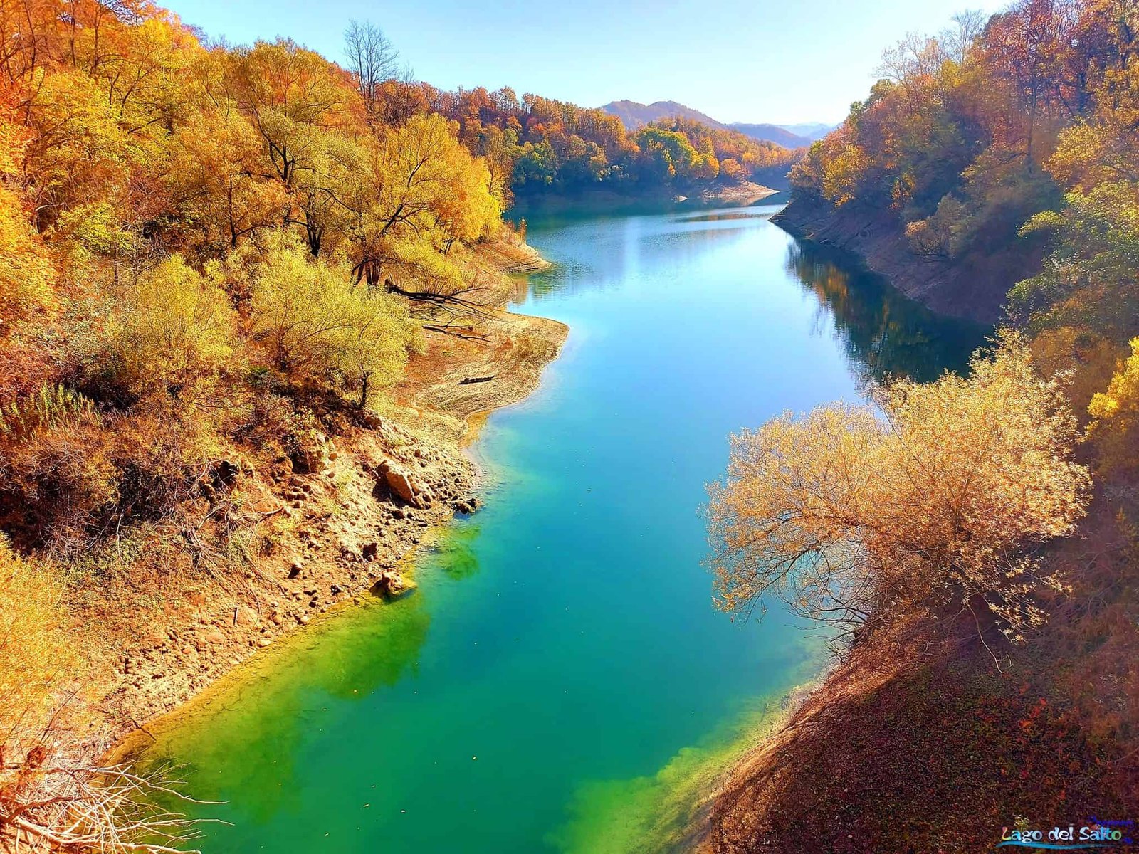

Lake Salto (RI) is reached from State Road 578 Salto Cicolana, the axis that climbs from the Rieti plain up the Salto valley to Cicolano: coming from Rome you exit the A24 Roma Teramo at the Valle del Salto toll booth and in about 10 minutes you're on the shore. The main administrative reference is the municipality of Petrella Salto (RI), about 115 kilometers from Rome, with the lakeside hamlets of Borgo San Pietro and Fiumata where beaches, rentals and restaurants are concentrated. The body of water is free and open: there's no ticket, there are no hours, no need to book. You pay only for what you choose to use, that is umbrella and lounger at the seasonal beach clubs, canoe, pedal boat, wakeboard or a boat outing, with price lists that operators post on site and that change from year to year. Swimming is allowed at the points officially designated as bathing waters, which fall in the municipalities of Petrella Salto, Fiamignano, Marcetelli, Pescorocchiano and Varco Sabino. Outside those stretches you swim at your own risk and in some periods the local authority can ban swimming and navigation. The reference body for the protected territory is the Monte Navegna and Monte Cervia Regional Nature Reserve, based at Via Martin Luther King 1 in Varco Sabino (RI), phone 0765 790002. The useful swimming period runs from June to mid-September. The rest of the year the lake remains beautiful and almost deserted.
To get a sense of the area it's worth keeping at hand also the page on Lake Turano, which is the hydraulic twin of this basin, and the one on Rieti, the provincial capital and natural logistics base for those arriving from outside the region.

Frequently asked questions about Lake Salto (RI)
Where exactly is Lake Salto?
Lake Salto is in the province of Rieti, in Cicolano, along the valley of the Salto River. It falls mainly in the municipality of Petrella Salto and, for stretches of shoreline, in the municipalities of Pescorocchiano, Fiamignano, Varco Sabino and Marcetelli, in that band of mountains that marks the border between Lazio and Abruzzo.
How much does it cost to enter Lake Salto?
Nothing: Lake Salto is freely accessible and there is no entrance ticket. You pay only for the private services you may choose, such as rentals or activities on the lake, while the shore and the villages overlooking the water can be visited for free.
How do you get to Lake Salto by car?
To get to Lake Salto by car the main route is State Road 578 Salto Cicolana, which starts from the Rieti basin and runs alongside the Salto River into Cicolano. Those leaving from Rome can also take the A24 motorway and exit at Valle del Salto, then continue toward the reservoir.
Can you swim in Lake Salto?
Yes, the waters of Lake Salto are included in the regional list of bathing waters, with sampling points spread across the municipalities of Petrella Salto, Fiamignano, Marcetelli, Pescorocchiano and Varco Sabino. The classification by the Lazio regional environmental protection agency for the 2025 season also covers this basin together with Turano.
Is Lake Salto suitable for children?
Yes, Lake Salto works well with children under three conditions: make your base at Fiumata or Borgo San Pietro, where there are services, shade and gradual access to the water, try a pedal boat or canoe in the early afternoon, and tell the story of the villages that ended up underwater in 1940 well, in front of the lake.
What is the best time to visit Lake Salto?
The best time to visit Lake Salto is the second half of September, when the water is still lukewarm and the beaches empty out. July and August are considered the worst months, because the beaches get crowded, the narrow roads become a problem and the level of the reservoir starts to drop, showing the exposed band of shoreline.
Is it true that there are submerged villages under Lake Salto?
Yes, the filling of the reservoir in 1940 erased four real inhabited centers, with their houses, their churches and their cemeteries: Borgo San Pietro, Teglieto and Fiumata, hamlets of Petrella Salto, and Sant'Ippolito, a hamlet of Fiamignano. The residents were relocated and the villages rebuilt on the shores, higher up, a short distance from the water.
How to get to Lake Salto
By car to Lake Salto
There is only one main road and it's called Salto Cicolana. State Road 578 starts from the Rieti basin, runs alongside the Salto River and accompanies it into Cicolano, that band of mountains that marks the border between Lazio and Abruzzo and that for centuries was a land of passage between the Kingdom of Naples and the Papal States. Coming from Rome you have two options. The first is the A24: you exit at Valle del Salto and find yourself immediately in the upper part of the basin, around Fiamignano and Sant'Ippolito. The second is the Salaria to Rieti and then the 578 toward Avezzano, which is slower but more beautiful, because the lake opens up in front of you suddenly after a bend and that first sight is worth the extra half hour.
The secondary accesses are mountain roads, narrow and sometimes without guardrails, but they're the most memorable: from the Abruzzo side you come down from Tornimparte, from the lower Sabina you arrive from Lake Turano crossing the Navegna ridge, from the Carseolano you pass through Pietrasecca, and there's the route through the village of Torano Grotti. Blunt advice: if it's your first time, enter by the 578 and leave by one of these, never the other way around. The lake is understood better this way, first from the water and then from above.
Lake Salto by public transport
Here we have to be honest: it's not a bus destination. The intercity connections serving Petrella Salto and the hamlets of Cicolano exist but have frequencies designed for commuters and students, with sparse runs on weekends and in summer. Check the schedules on the website of the regional road transport operator before leaving, because they change every school season. Those without a car who still want to see the lake have two sensible options: arrive by train in Rieti and rent a vehicle there, or arrange with a guide who handles the logistics, which is the most practical solution for groups. For how tourist accompaniment really works in Italy there is a serious explanation, written by people who do it for a living.
Going around Lake Salto by car and by bicycle
The lakeside road is not a perfect ring as at Turano, but the circuit can be done: counting detours, small bridges over the inlets and stops, the coastline runs to something like 57 kilometers, and the full loop takes a full half day if you want to go down to the beaches and up to the villages. By bicycle it's a route for trained legs: the elevation changes are continuous, the hairpins are tight, the asphalt in places is patched. But traffic is practically nonexistent outside July and August, and in autumn, with the chestnut trees turning, it's one of the most beautiful rides in inland Lazio.
Lake Salto in numbers
How big is Lake Salto
Lake Salto is the largest artificial basin in Lazio. It sits at an elevation of about 535 meters above sea level when the reservoir is at maximum regulation, it's around 10 kilometers long and on average a little over one wide, and at the deepest point, near the dam, it goes well past 100 meters: hydrographic sources indicate about 108 meters below the dam. These numbers need a caveat: in a hydroelectric reservoir the level is never the same. The swing between the spring maximum and the end-of-season minimum can exceed 20 meters, and with it change the surface, the perimeter, the shape of the beaches and even whether certain access ramps to the water can be used.
The Salto is a left-bank tributary of the Velino, and the Velino in turn is the river that at Terni plunges down the Cascata delle Marmore. Whoever looks at this water is looking, a few dozen kilometers ahead of time, at the same water that will form the most famous waterfall in Italy: it's worth keeping in mind when you later visit the Marmore Falls.
Why Lake Salto looks like a fjord
The shape is its signature. The lake doesn't have the rounded plan of the volcanic lakes of Lazio, like Lake Bracciano: it's a very long, thin ribbon of water that faithfully follows the old furrow of the valley, and every side gully that came down from the mountains has become a deep inlet, with wooded walls that drop steeply to the water's edge. The result looks more like a Scandinavian fjord on a reduced scale than an Apennine lake, and produces a curious optical effect: from many points on the shore you can't see where the lake ends, because the coast closes in on itself.
The two shores don't resemble each other at all. The southwest one is shady, covered with oak and chestnut woods that reach the water and keep it cool even at mid-August. The opposite one, better exposed to the sun, hosts cultivated fields, high-altitude olive groves and the small inhabited centers. It's a difference you feel on your skin: the same hour of the afternoon, on the two banks, seems to belong to two different seasons.
The Salto Dam and the birth of the lake
From the plan to the construction
The idea of damming the Salto is older than the lake. The first organic plan for the hydroelectric exploitation of the valley bears the signature of the engineer Guido Rimini, chief engineer of the province of Perugia, and dates to 1916: those were the years when the Italian electric industry was realizing that the central Apennines, with their elevation drops and their waters, were an energy reserve to be put to profitable use. The project stayed on the drawing board for more than 20 years. It was the Società Terni per l'Industria e l'Elettricità, the giant that powered the Umbrian steelworks, that brought it to completion between the late 1930s and 1940, when the reservoir began to fill.
The dam is a concrete structure over 90 meters high that closes the valley in the northwest sector of the lake. For some years it was among the tallest dams built in Italy, and local memory recalls it as the tallest of all at the moment it entered service: it's a record that circulates in the oral tradition of Cicolano and that is worth reporting for what it is, that is a community memory, not a registry datum. The official technical parameters of the work, from the crest elevation to the authorized reservoir volume, are those filed with the national authority responsible for large dams.
The plaque to the victims of the construction site
On the northwest edge, near the dam, a large plaque carved into the rock commemorates the workers who died during the works. It's not a showy monument and very many visitors walk past it without seeing it. Building a dam of that size in the late 1930s meant working with explosives, wooden scaffolding, steam winches and very few protections, in a valley where labor was recruited among farmers who had never seen an industrial site. Stopping for a minute in front of that stone is the quickest way to understand that this so quiet landscape has a price written at the bottom of the receipt.
The tunnel that joins Lake Salto to Turano
The most interesting thing about Lake Salto hydraulically can't be seen. Under the ridge of Monte Navegna, which reaches 1,508 meters, runs an artificial channel about nine kilometers long that connects this basin with that of Turano, dammed in turn by a dam built near Posticciola. The two lakes therefore work as a single reservoir with two chambers: water is moved from one to the other according to operating needs, and that's why you sometimes find the Salto full and the Turano visibly lower, or vice versa.
The Cotilia power plant and the steel of Terni
The end point of all this water is the Cotilia hydroelectric plant, in the San Vittorino plain, which went into operation in 1942. It was built to serve the Terni steelworks, that is to supply power to one of the country's strategic industries in the middle of a wartime economy. Understanding this means understanding why the lake exists: nobody created it for swimming. It was born as the hydraulic battery of a steelworks, and the fact that today it's also a vacation destination is, historically speaking, a side effect.
The villages submerged by Lake Salto
What ended up underwater in 1940
The filling of the reservoir erased four real inhabited centers, with their houses, their churches, their cemeteries and their fields: Borgo San Pietro, Teglieto and Fiumata, hamlets of Petrella Salto, and Sant'Ippolito, a hamlet of Fiamignano. The residents were relocated and the villages rebuilt on the shores, higher up, a short distance from the water. It wasn't a move: it was the complete replacement of a piece of the world. Whoever was born before 1940 in that valley spent their life with two maps in their head, the one above and the one below.
Of the reconstruction, what's remembered above all is the new Borgo San Pietro, considered an example, however marginal and peripheral, of Italian rationalist architecture in a province that during Fascism saw mostly rural and forestry works. Look at it carefully: the geometry of the buildings, the regular layout around the parish church, the logic of a settlement designed at a drafting table and not grown by accumulation. It's a village without crooked alleys, and in Cicolano this is a glaring anomaly.
The monastery of Santa Filippa Mareri
The most important piece the lake took is the monastery of San Pietro de Molito, founded in 1228 by the noblewoman Filippa Mareri, a follower of the Franciscan experience and a leading figure in women's monasticism in 13th-century central Italy. The complex ended up under the waters in 1940, and the community of Poor Clares was transferred to the new monastery in Borgo San Pietro, where the nuns still live. In the new church, with a single nave, the apse is decorated with a fresco by the friar-painter Ortensio Gionfra depicting the lake and the surrounding mountains: a 20th-century work that tells, inside a religious building, exactly the event that forced that building to exist.
Of the saint, who died in 1236, the heart reliquary is preserved, kept in the chapel of the complex together with 16th-century frescoes recovered from the old site. Devotion to Filippa Mareri isn't folklore for tourists: it's a living practice of Cicolano, and whoever happens to be here on the days of the celebrations finds the streets full of people who have come from all the hamlets.
What re-emerges when Lake Salto drops
This is the part that attracts most of the curious, and it's also the one to handle with more caution. When the reservoir level falls markedly, typically at the end of summer or in years of strong low water, strips of the submerged settlements resurface: walls, road layouts, foundations, and according to testimonies gathered on the spot the top of the bell tower of the old 13th-century monastery of the Poor Clares. It's a phenomenon documented by local chronicles and amateur photographs, not a schedulable event: there's no calendar, no date, it depends exclusively on hydroelectric operation and the hydrological season. Those who arrive hoping to see the ghost village most of the time simply find a beautiful full lake.
A practical and non-negotiable warning: the zones that re-emerge are unstable mud, with iron bars, rubble and wells. They're not walks. You look at them from the shore or from the boat, you don't cross them.

The monastery museum and the paintings by De Chirico
Inside the monastery of Borgo San Pietro there's a museum that is worth the trip by itself, and that almost nobody knows. It collects what could be saved from the old complex of San Pietro de Molito before the flooding: furnishings, household objects, documents, objects of the Poor Clares' daily life, and above all the frescoes detached from the Grotta di San Nicola, considered the oldest pictorial document of Cicolano, with 13th-century stylistic features of an Orientalizing taste.
Then there's the surprise. In the museum's rooms are displayed paintings by Giorgio De Chirico, including a self-portrait and an Adoration of the Crucified Christ in which, at the foot of the cross, next to the Magdalene and the centurion, a horse appears, a recurring motif of the painter and read here as his figure of himself before faith. The link is biographical, not casual: the De Chirico household's housekeeper, Vincenzina, came from Petrella Salto, and through her the painter and his wife Isa got into the habit of spending the summer up here starting in the 1950s. The works came to the nuns by bequest. The visit is run by the nuns and has no organized ticket office: you ring, you ask, and almost always someone opens. A common-sense rule: call ahead, and don't show up during liturgical hours.
Petrella Salto and the fortress above Lake Salto
The municipal seat is high up, dominating the valley, and is reached by a climb of hairpin bends that by itself deserves the detour. Above the village, in ruins but still legible, are the remains of the fortress, the one everyone in the area calls the rocca of Beatrice Cenci. The name isn't advertising: it's there that the most famous judicial case of late 16th-century Rome had its violent epilogue.
The established facts are these. Francesco Cenci, a Roman nobleman born in 1549, kept his daughter Beatrice, born in 1577, and his second wife Lucrezia Petroni confined in the fortress of Petrella. In 1598 Francesco was killed and his body thrown from a balcony to simulate an accident. Among the actual perpetrators the trial tradition names Olimpio Calvetti, and among those who commissioned it, his son Giacomo. The trial, demanded by Pope Clement VIII, ended with the death sentence: Beatrice, Giacomo and Lucrezia were beheaded in Rome in front of Ponte Sant'Angelo in 1599. Beatrice was 22 years old. From then on her story leaves the case files and enters European literature, but the wall where it all began is the one you have in front of you, above Lake Salto.
In the municipal territory there are two other things I recommend: the church of Sant'Andrea and the collegiate church of the Santissima Annunziata, of medieval layout, and the sanctuary of Santa Maria Apparì, built where in 1562 a girl named Persiana is said to have had a vision of the Virgin. Here, on the last Sunday of May, the blessing of the cherries is celebrated: one of those agricultural festivals that no national guide mentions and that tell Cicolano better than a museum.
The villages overlooking Lake Salto
Fiumata and Borgo San Pietro
These are the two bathing hubs. Fiumata has the most convenient access to the water and the greatest concentration of summer services, Borgo San Pietro adds the monastery, the museum and an overall view of the basin that is the classic postcard of the place. If you have only one day and are bringing children, make your base here and don't move.
Rigatti and Varco Sabino
Rigatti, a hamlet of Varco Sabino, is a hilltop village of medieval layout, with very narrow alleys, stone houses and a castle of which recognizable structures remain: its foundation is placed around the 12th century. From above the lake can be seen in its entirety between two ridges, and it's probably the best viewpoint of the whole basin. Varco Sabino also hosts the seat of the nature reserve and is the most logical starting point for excursions toward the Navegna. A little further west, beyond the ridge, begins the territory of Paganico Sabino and Castel di Tora, which belong to the Turano side.
Fiamignano, Pescorocchiano and Marcetelli
Fiamignano occupies the upper head of the valley and administers Sant'Ippolito, the fourth of the submerged villages. Pescorocchiano is the largest municipality in Cicolano and preserves a heritage of rural churches and karst caves that would deserve a chapter of its own. Marcetelli is tiny, one of the least populated centers in Lazio, and overlooks the lake from a position that on tramontana days gives one of the cleanest views over the entire Rieti Apennines. None of these three is a tourist village: you visit them for what they are, not for what they offer.
Swimming in Lake Salto
The water quality of Lake Salto
The waters of the lake are included in the regional list of bathing waters, with sampling points spread across the municipalities of Petrella Salto, Fiamignano, Marcetelli, Pescorocchiano and Varco Sabino, and the classification by the Lazio regional environmental protection agency for the 2025 season assigns to the Rieti basins, Salto included along with Turano, Ventina and Scandarello, the excellent category, the highest provided by the regulations. It's a fact that surprises those who imagine a murky industrial reservoir: the water is clear, cold and low in algae. Monitoring runs from April to September, and the results point by point are published by the regional agency during the season.
The beaches of Lake Salto
Don't expect white sand: the beaches are tongues of fine gravel and packed earth, carved out where the slope allows. The most frequented equipped areas are at the campground near the dam, at Fosso Petrella, in the Altobelli area, at Fosso Pratostretto in Fiumata and at Fosso delle Foche. In high season you'll find rental of umbrellas, loungers, pedal boats and canoes, kiosks and restrooms. Off season you'll find the lake and nothing else.
What you need to know before getting in the water
Lake Salto is a hydroelectric reservoir, and that changes everything compared with a natural lake. The bottom drops off quickly a few meters from the shore, the temperature falls sharply below the first two meters even in August, and the reservoir level varies according to operating maneuvers: last year's beach may no longer be there. In the unequipped areas there is no lifeguard. In summers of high wildfire risk, when aircraft draw water from the basin, the authorities can issue ordinances temporarily banning swimming and navigation. These are serious bans, not formalities, and must be respected to the letter. The rule is simple: you swim in the stretches marked as swimmable, in front of the equipped areas, and never alone.
Sports and activities on Lake Salto
Wakeboarding on Lake Salto
The Salto is one of the most serious places in central Italy for wakeboarding, the discipline practiced on a light board towed by a cable or a boat, cousin of water skiing. The reasons are technical: water almost always flat thanks to the high banks that cut the wind, long free straights, no commercial boat traffic. National and international level competitions have been held on the water, and in season the local schools offer lessons even for absolute beginners. If you saw someone jumping on the water while you were passing on the 578, this was it.
Canoe, kayak and pedal boat
The shape with its inlets makes the lake a playground for the paddle: you enter a side gully, you shut off every noise, and for 20 minutes you have the impression of sailing in a flooded canyon. Rentals are found at Fiumata and Borgo San Pietro. Practical advice: start early in the morning, because in the afternoon, especially from mid-July, a breeze rises that you pay dearly for on the way back.
Diving in Lake Salto
There are centers that organize guided dives on the remains of the submerged settlements. It's an activity for certified and accompanied divers: you go down in fresh, cold water, with variable visibility and with ruined structures that can collapse or trap you. It's not something you improvise with a mask and fins bought at the supermarket, and whoever offers it to you without certification should be avoided.
Sport fishing on Lake Salto
Fishing is regulated and requires a license and respect for the closed seasons. The fish population is almost entirely non-native or the result of restocking, as happens in all artificial reservoirs: carp and grass carp, tench, trout, eel, chub, crucian carp, roach, bream, bleak, European perch, largemouth bass, pumpkinseed, pike, wels catfish, rudd, whitefish. Among crustaceans there are the Turkish crayfish and the American crayfish, two introduced species that weigh not a little on the basin's balance. It's the wildlife richness most cited when talking about the lake, and it's also the one that most tells of its artificial nature: here the fauna isn't an inheritance, it's a project.
The nature around Lake Salto
Between two nature reserves
The basin occupies a fortunate position, halfway between two important protected areas: the Monte Navegna and Monte Cervia Nature Reserve, which is based in Varco Sabino and protects the ridge between Salto and Turano, and the Montagne della Duchessa Nature Reserve, which protects the slope toward the Velino and its high-altitude environments. The contiguity of these two systems guarantees a biodiversity that nobody expects looking at an industrial reservoir. Up-to-date information on trails, ecomuseum and environmental education activities should be requested directly from the managing body, at Via Martin Luther King 1 in Varco Sabino. Those who want to widen the tour will find the complete mountain system described on the page of Monte Navegna and Monte Cervia.
Birds and mammals
On the water and the shores you can observe grebes, gulls, mallards and other wintering ducks. Among raptors the peregrine falcon is reported on the rock walls, and among night birds tawny owl, barn owl and little owl, which in the evening can be heard very well from the woods above the inlets. In the woods live wild boar, foxes and badgers, together with many species of amphibians and reptiles and a very rich community of invertebrates, which is the part of the ecosystem that nobody photographs and that holds up everything else.
Woods, climate and seasons
The slopes that descend to the lake are covered with dense woods of oak and chestnut, with some conifer reforestation plantings dating back to the very years of the great works. The climate of the lower band is the typical hilly one: winters not particularly harsh and humid, moderated by the mass of deep water that works as a thermal flywheel. Climbing toward the ridges the picture changes quickly, with decidedly colder winters, though still softened by the presence of the lake. Summers are hot and at times muggy, and this, paradoxically, is the reason why people from Rieti and L'Aquila come here: the water stays cold even when the air is unforgiving.
The Pilgrim's Trail and the cave of Santa Filippa
The most significant hiking route in the area is the Sentiero del Pellegrino, which can be done on foot, on horseback or by mountain bike and leads to the cave where, according to the hagiographic tradition, Filippa Mareri withdrew before founding the monastery. The cave is in the locality of Piagge, you walk inside a dense wood, and in the open stretches you gain glimpses of the mountains of Cicolano. It's not a difficult trek, but it's not a stroll either: proper shoes, water, and in summer an early start.
When to go to Lake Salto
I'll give a sharp opinion, because on this tourist rhetoric is systematically wrong. July and August are the worst months for understanding Lake Salto: the beaches get crowded, the narrow roads become a problem, and the reservoir level starts to drop, showing the exposed band of shoreline, which is not pretty. The best time absolutely is the second half of September, when the water is still lukewarm, the woods begin to turn and the lake goes back to belonging to those who live there. The second best time is May, with the reservoir at its maximum, the broom in bloom and long days. For those who come only to photograph and walk, November and the end of January, with crystal clear air, are days that are worth double.
Lake Salto with children
It works, under three conditions. The first: base at Fiumata or Borgo San Pietro, where there are services, shade and gradual access to the water. The second: pedal boat or canoe in the early afternoon, which is the activity that wins them all over here, better than any museum. The third: the story of the village underwater told well, in front of the lake, before entering the monastery museum. No eight-year-old can resist the idea that under that water there's a bell tower. Avoid instead long walks in the middle hours of summer and the unequipped shores, where the bottom drops off immediately.
What to see around Lake Salto
The lake lends itself to being the center of a trip of three or four days in inland Lazio, and this is the combination I suggest most often. To the north in half an hour you reach Rieti with its basin and the Franciscan sanctuaries, among them the Sanctuary of Fonte Colombo, and a little further Poggio Bustone and Rivodutri. To the east you climb to Terminillo and continue to Leonessa and Amatrice. Along the old Salaria you meet Cittaducale, Antrodoco and Borgo Velino. On the opposite side of the ridge you go down to Lake Turano and continue to Collalto Sabino and Orvinio. Those traveling with foreign guests who want to prepare the itinerary in English will find an orderly overview of the region in the ItalyPlanner guide to Lazio and a reasoned selection of day trips on the page dedicated to day trips in Italy.
Where to eat around Lake Salto
The cuisine of Cicolano is mountain food, not lake food, despite the lake. On the tables you find truffle, porcini mushrooms, pasture-raised meats, high-altitude legumes and cheeses, and among the recognized traditional products of Lazio appears the pizza rentorta, a rustic pie typical of this valley. Lake fish is there, but it's a recent presence in the local food history, for obvious reasons: 70 years ago there were no fish here. The trattorias are concentrated in Fiumata, Borgo San Pietro and the municipal seats. In winter many close or work by reservation only, so a phone call before setting out avoids unpleasant surprises.
A curiosity about Lake Salto (RI)
The most beautiful curiosity about Lake Salto is a railway that never existed. Before the reservoir was filled, the Salto valley had been identified several times as the natural corridor for a railway line between Rieti and Avezzano, that is between the Rieti basin and the Fucino: a connection that would have put into direct communication two of the great inland plains of the central Apennines and would have changed the economic destiny of Cicolano. The project was taken up repeatedly between the 19th century and the early 20th, discussed, relaunched, never built.
Then the dam arrived, and the hypothetical route ended up literally underwater along with the villages. It's a detail that says a great deal about how Italian infrastructure development worked in those years: between the railway, which would have brought people and goods, and the hydroelectric reservoir, which brought power to the steelworks, the second won, and the valley was paid twice, losing the villages and never getting the line. When you drive today on the 578 along the bends of Lake Salto it's worth keeping this in mind: that winding road, which everyone curses in summer, remained the only route of this valley because the railway alternative was postponed until it became impossible.
There's a corollary I gladly add. The memory of the missing railway is still alive among the elderly of Cicolano, and you may hear it cited in the bars of Petrella or Fiamignano the way one cites a wrong suffered, not as an anecdote. Few tourist curiosities have such a high emotional temperature: ask someone local about it and you'll realize you've opened a serious subject.
Something nobody tells you about Lake Salto (RI)
No guide writes it, but Lake Salto and Lake Turano are the same plant, and this has concrete consequences for your day. Under the ridge of Monte Navegna runs an artificial channel of about nine kilometers that transfers water between the two basins according to the operating needs of the Cotilia plant. It means that the level of the two lakes is decided by an office, not by the rains, and that they can be in opposite conditions on the same day.
The practical consequence is this: before planning a beach day or a canoe outing it's worth knowing that the shoreline is not a fixed datum. In years of strong hydroelectric demand the Salto can show up with an exposed band of shore of several meters, muddy and not very inviting, while the Turano stays full, or vice versa. Those who know the system always keep plan B ready 20 kilometers away, on the other side: that's why the locals, when they organize an outing, decide the destination that same morning and not the week before.
I'll add the second part, the one that surprises even more: the drop in level is not a malfunction or a sign of drought, and it's completely normal in the second part of the summer. The basin is filled with the spring snowmelt and discharged progressively during the hydrological year. Whoever arrives at the end of August and finds the beach lower than they left it in June has not witnessed an environmental disaster: they have simply seen the machine work that this lake was built to be.
The advice I give you for visiting Lake Salto (RI)
The advice is counterintuitive: don't treat Lake Salto as a beach destination, treat it as an itinerary. Whoever arrives at 11, sets up the umbrella at Fiumata, eats a sandwich and leaves at six has seen maybe a fifth of the place, and almost always goes home saying it's nice but nothing special. The basin is understood by going around it.
The recommended day is this. Early start, first stop at the dam to grasp the scale of the work and find the plaque carved into the rock. Then Borgo San Pietro, monastery and museum, with the phone call made the day before. Next the climb to Petrella Salto and to the ruins of the fortress, which is the point where the Cenci story stops being literature and becomes a wall. Lunch in the village, not on the lakefront. Afternoon in the water at Fiumata or, if you have the legs, a partial circuit with a stop at Rigatti for the view. Return at sunset along the shady shore, which at that hour is spectacular.
Two professional warnings. The first: phone coverage here is patchy, so download the maps before leaving and expect stretches without signal. The second: fuel. Gas stations are few and keep village hours, and running dry on a mountain lakeside road at seven on a Sunday evening is a real problem. You fill up in Rieti or at the motorway exit, always. For those who organize group transfers in these conditions, what makes the difference is having logistics planned beforehand: it's exactly the ground on which those who deal with group travel organization in Italy work.
Another well-known fact, yet rarely cited
That Lake Salto is artificial everybody knows. That it was built for a steelworks few say, and almost nobody explains what that entails. The Società Terni per l'Industria e l'Elettricità wasn't just any electric company: it was the group that supplied steel to the navy and to Italian heavy industry, and its hunger for energy was enormous and constant. The Salto Turano system was born for that, and the Cotilia plant, in the San Vittorino plain, went into operation in 1942, that is in the middle of the war effort.
The rarely mentioned fact is the social consequence of this choice. The valley did not receive industry, stable employment or infrastructure in exchange: it received the relocation of four villages, the loss of the valley-floor farmland, which was the best, and the replacement of a peasant economy with a condition of marginality. Emigration from Cicolano in the 1950s and 1960s has many causes, and this is one of the ones named least.
There is also a technical side that deserves to be known. The connecting tunnel under the Navegna, nine kilometers dug into the mountain in the late 1930s, is a remarkable piece of engineering for the time, built without the mechanized excavation technologies we take for granted today. Nobody sees it, nobody visits it, it appears on no list of monuments. Yet it is probably the boldest structure in the whole area, and it supports, invisibly, everything you see on the surface.
The right photo to take at Lake Salto (RI)
The photo everybody takes is the one from the bridge, with the lake receding between the two wooded shores. It's a good photograph and there's nothing wrong with taking it home, but it's not the best this place can give.
The best is taken from above Rigatti, or from one of the hairpin bends climbing toward Petrella Salto, in the last hour of light. From up there you catch the thing that makes Lake Salto unique: the fjord shape, that is a ribbon of water that slips between the ridges and disappears behind a bend, with the side inlets looking like fingers. Technically you need a medium focal length, around 50 millimeters equivalent, because the wide angle flattens the planes and kills the depth. It's best to expose for the sky and let the shores go into shadow, because it's precisely the contrast between the light water and the dark woods that builds the image.
The second shot I recommend is at water level, early in the morning, from the shores of Fiumata, when the surface is still and returns the perfect reflection of the mountains. You need half past seven in the morning and a bit of luck with the wind, but when it works it's a photograph nobody imagines could come from Lazio. And if you happen to come during a period of low reservoir, the third photo is the one of the exposed band of shoreline with the traces of the settlements: documentary, not beautiful, but it's the photograph that truly tells what happened here in 1940. A serious warning: those surfaces are photographed from the shore or from the boat, not by walking on them.
Some important events that happened here in history
The first event is medieval and concerns the founding, in 1228, of the monastery of San Pietro de Molito by Filippa Mareri, a noblewoman of Cicolano who embraced the Franciscan experience and organized here one of the first women's communities of that spirituality in central Italy. Filippa died in 1236 and her cult took root immediately throughout the valley. For more than 700 years that monastery was the religious, cultural and in large part economic center of gravity of the territory.
The second event is the Cenci murder of 1598, carried out in the fortress above Petrella Salto, where Francesco Cenci kept his daughter Beatrice and his wife Lucrezia Petroni confined. The killing, disguised as an accidental fall from a balcony, opened a trial demanded by Pope Clement VIII that closed in 1599 with the beheadings in front of Ponte Sant'Angelo, in Rome. It is one of the few cases of 16th-century Roman judicial news that has crossed the centuries generating a European literary tradition, and its initial setting is this mountain above the lake.
The third event is the construction of the dam and the filling of the reservoir in 1940, which erased Borgo San Pietro, Teglieto, Fiumata and Sant'Ippolito and rewrote the entire human geography of the valley. It is the event that divides the history of this territory in two: there is a before and an after, and it is not a figure of speech.
The fourth is the entry into service of the Cotilia plant in 1942, in the middle of the war, which placed this Apennine valley in the industrial chain of Italian steel. The fifth, more recent and of a totally different tone, is cinematic: Gabriele Salvatores shot some scenes of Siberian Education in these landscapes, bringing an international crew for a few weeks among the lake shores and the woods of Cicolano. The sixth, finally, is the 20th-century story of Giorgio De Chirico's bequest to the Poor Clares of Borgo San Pietro, which deposited in a mountain monastery works by one of the most important painters of the century.
Who has been through Lake Salto (RI)
Filippa Mareri, first of all. She is not a peripheral figure: she is the founder of the 1228 monastery, the character around whom the religious identity of the valley revolves, and her cave in the locality of Piagge is still today a pilgrimage destination along the Sentiero del Pellegrino. She died in 1236, and her memory also went through the 1940 submersion: the community of Poor Clares carried with it the heart reliquary and the 16th-century frescoes to the new site.
Then the Cenci family. Francesco, born in 1549 and killed in the fortress in 1598, Lucrezia Petroni his second wife, and above all Beatrice, born in 1577 and beheaded in Rome in 1599 at 22. If you find the judicial reading of the character convincing, or the romantic one, the fact remains that this mountain above Lake Salto is the material setting of one of the most told stories of European modern history.
Then Giorgio De Chirico, and this is the passage that most amazes visitors. The painter, together with his wife Isa, got into the habit of spending summer periods in Petrella Salto starting in the 1950s, because of the tie with the household's housekeeper, Vincenzina, who came from the place. From that habit came the bequest to the nuns: a self-portrait and an Adoration of the Crucified Christ, with that horse at the foot of the cross that is at once signature and confession. These are works now displayed in the museum of the monastery of Borgo San Pietro, and seeing them at 700 meters of elevation, in an Apennine valley, produces an effect of disorientation that is almost De Chirico-like in itself.
There is then the friar-painter Ortensio Gionfra, author of the apse fresco of the new church, who depicted the lake inside the church that the lake had forced to be built. And there is Gabriele Salvatores, who arrived here with the crew of Siberian Education. Finally, dozens of international wakeboard athletes pass through this lake every year, choosing the flat water of the Salto to train and compete: they are not characters for a history textbook, but they are the reason the name of this basin circulates in sports circles well beyond the borders of the Rieti area.
Quick questions about Lake Salto (RI)
Where exactly is Lake Salto (RI)
In the province of Rieti, in Cicolano, along the valley of the Salto River. It falls mainly in the municipality of Petrella Salto and, for stretches of shoreline, in the municipalities of Pescorocchiano, Fiamignano, Varco Sabino and Marcetelli.
How much does it cost to enter Lake Salto
Nothing. The lake is freely accessible and there is no entrance ticket. You pay only for seasonal private services, that is umbrellas, loungers, rentals and private parking, with rates posted by the operators.
Can you swim in Lake Salto
Yes, in the stretches identified as bathing waters by the Lazio Region, which are found in the five lakeside municipalities, and in particular in front of the equipped areas of Fiumata, Borgo San Pietro and the dam area. Outside those stretches there is no lifeguard and local bans may apply, which must be respected.
Is the water of Lake Salto clean
The classification by the Lazio regional environmental protection agency for the 2025 season places the waters of the Rieti lakes, Salto included, in the excellent category, the highest provided. Checks run from April to September and the specific results can be consulted on the agency's portal.
How deep is Lake Salto
The point of maximum depth is near the dam and hydrographic sources indicate about 108 meters. The bottom drops off quickly even near the shore, and it's the main reason it's best to swim only in the marked areas.
Why does the level of Lake Salto change so much
Because it's a hydroelectric reservoir. Water is stored and released according to the needs of the Cotilia plant, and part of it is transferred to Lake Turano through a tunnel of about nine kilometers under Monte Navegna.
Can you really see the submerged villages in Lake Salto
Only when the level drops markedly, and not on a predictable calendar. In those conditions walls, layouts and, according to local testimonies, the top of the bell tower of the old monastery re-emerge. On most visits none of this can be seen.
Can you walk on the ruins that re-emerge
No, and it's a terrible idea. They are muddy, unstable surfaces, with rubble, iron bars and cavities. They are observed from the shore or from the water.
Which villages were submerged by Lake Salto
Borgo San Pietro, Teglieto and Fiumata, hamlets of Petrella Salto, and Sant'Ippolito, a hamlet of Fiamignano. They were rebuilt on the shores, not far from the water.
When was Lake Salto created
In 1940, with the damming of the Salto River carried out by the Società Terni. The Cotilia hydroelectric plant, which uses these waters, went into operation in 1942.
How tall is the Salto dam
It exceeds 90 meters. It was among the tallest dams built in Italy in those years, and the official technical data are those filed with the national authority that oversees large dams.
Can you visit the Salto dam
The dam is an industrial plant in operation and cannot be freely visited. It is observed from the outside, from the road and from the viewpoints. Nearby is the plaque commemorating the victims of the construction site.
How far is Lake Salto from Rome
The municipal reference of Petrella Salto is about 115 kilometers from Rome. By motorway, with the A24 and the Valle del Salto exit, the real travel time is a little over an hour and a half in normal conditions.
How do you get to Lake Salto without a car
It's complicated. Bus connections for Cicolano have frequencies designed for residents and must be checked on the website of the regional operator. The workable solution is the train to Rieti and then a rental vehicle, or an organized service.
Is Lake Salto suitable for children
Yes, if you stay in the equipped areas of Fiumata and Borgo San Pietro, where access to the water is gradual and there are services and shade. Pedal boats and canoes are the activity that works best with the youngest.
Can you bring a dog to Lake Salto
In the free areas generally yes, on a leash and with common sense, while in the beach clubs and equipped areas the decision is up to the operator. In the nature reserve zones the body's rules apply, which you ask for at the Varco Sabino office.
What sports can you do on Lake Salto
Wakeboard, which is the specialty for which the lake is known even outside the region, canoe and kayak, pedal boat, swimming in the swimmable areas, guided dives with certification and regulated sport fishing.
Do you need a license to fish in Lake Salto
Yes. Sport fishing requires the license provided by regional regulations and respect for seasons, gear and catch limits. Up-to-date information should be requested from the competent provincial offices.
What fish are in Lake Salto
Species almost all introduced or from restocking: carp and grass carp, tench, trout, eel, chub, crucian carp, roach, bream, bleak, European perch, largemouth bass, pumpkinseed, pike, wels catfish, rudd, whitefish, as well as the Turkish crayfish and the American crayfish.
What is the difference between Lake Salto and Lake Turano
They are two reservoirs of the same hydroelectric plant, connected by a tunnel. The Salto is bigger, longer and wilder, with wooded shores and few services. The Turano is more intimate and has villages overlooking the water such as Castel di Tora and Colle di Tora, with a more established tourist vocation.
How much time do you need to visit Lake Salto
A full day for a tour that includes the dam, Borgo San Pietro with the museum, Petrella Salto and a swim. Two days if you want to add the Sentiero del Pellegrino, Rigatti and the high villages of Cicolano.
Can you visit the museum of the Borgo San Pietro monastery
Yes, the visit is run by the nuns and does not work with a ticket office and fixed turns. It's best to phone the monastery first and show up outside liturgical hours.
Where do you park at Lake Salto
In the parking areas by the equipped beaches and along the permitted stretches of the lakeside roads. In August spaces are few and fill up early: arriving before 10 makes the difference.
When is the best time to go to Lake Salto
The second half of September, with water still lukewarm and no crowds, and alternatively May, with the reservoir at its maximum levels. July and August are the most crowded months and the ones in which the landscape looks worst.
Are there restaurants at Lake Salto
Yes, mainly in Fiumata, Borgo San Pietro and the municipal seats, with mountain cooking based on truffle, mushrooms, meats and cheeses, and the pizza rentorta among the traditional products of the valley. Off season many businesses work by reservation.
Final notes on Lake Salto (RI)
There are many water places in Lazio, and almost all of them have a more comfortable tourist vocation than this one. Lake Salto is not comfortable: the roads are narrow, services are seasonal, the water level changes, and to see it well you have to drive quite a lot. But it's the only Lazio basin that carries on itself, so legibly, the story of an industrial choice that rewrote an entire valley. If you come, come for that, as well as for the swim: look at the plaque near the dam, go into the museum of the Poor Clares, climb to the ruins of the fortress, and then sit down on a shady shore at the end of September. That silence is not natural. It was built in 1940, and knowing how makes the day far more interesting.
Article written by the editorial staff of TourLeaderPro, contact them for Private/Corporate/V.I.P. Tours and Experiences.
Planning a trip to Rome? The English-language guides to visiting the city are on ItalyPlanner.com.