Campo Soriano (LT)
In short. The Campo Soriano Natural Monument occupies a karst basin at about 360 meters above sea level, straddling the municipalities of Terracina and Sonnino, in the province of Latina, and is reached by driving the Campo Soriano Provincial…
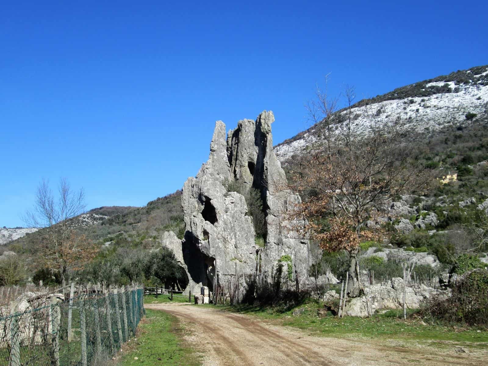
The Campo Soriano Natural Monument occupies a karst basin at about 360 meters above sea level, straddling the municipalities of Terracina and Sonnino, in the province of Latina, and is reached by driving the Campo Soriano Provincial Road that climbs from Terracina toward the interior of the Ausoni Mountains. Admission is free and unrestricted: there are no ticket offices, turnstiles or gate closing hours, because the protected area is not an enclosure but an open piece of mountain, with a paved road running through it, pullouts where you can stop, and trails that start directly from the edge of the roadway. The area was established as a Natural Monument by Regional Law No. 56 of April 27, 1985, and is now part of the Monti Ausoni and Lago di Fondi Regional Natural Park, established by Regional Law No. 21 of December 4, 2008. The managing body is based at Via Cavour 46 in Fondi (LT), telephone 0771 513644, email parcoausoni@regione.lazio.it: that is the address to contact for guided visits, permits and trail conditions. No public transportation enters the basin: you arrive by car, by bicycle or on foot from Terracina or Sonnino.
If you're planning a wider loop in southern Lazio, the area fits well with the coast and the hill villages around it: the page on tourist attractions collects the other destinations in the area.
Where Campo Soriano (LT) is and how to get there
Campo Soriano is not a town, not a hamlet with a square and a bar: it's a closed valley, a flat floor kilometers wide, surrounded by limestone ridges that cut it off from the rest of the world. Administratively the territory is split between Terracina and Sonnino, and this double belonging explains why you sometimes find it written as Camposoriano, all one word, and sometimes as Campo Soriano. The two spellings have always coexisted in documents and regional maps.
By car from Rome to Campo Soriano (LT)
From Rome the most direct road is the Pontina, the SS148, as far as Terracina, then you enter the city and take the climb toward the interior along the Campo Soriano Provincial Road. The Pontina is a fast-flowing road with traffic that gets seriously congested on summer weekends, especially on the stretch toward Latina and on Sunday-evening returns. Alternatively you can come down by the A1 motorway to Frosinone and then cross the Amaseno valley toward Sonnino, a route that is longer in kilometers but often smoother in August. From the capital allow roughly two hours of driving in normal conditions, more if you travel at the wrong hours.
My advice: if you're leaving Rome just to see Campo Soriano, leave early and be back for lunch. If instead you want to make the day count, plan Terracina alta and the coast too, because the karst basin is well visited in two or three hours and the rest of the time should be spent elsewhere.
By car from Terracina and from Sonnino
From Terracina the climb is short and spectacular: you leave the coast, pass the promontory on which the Temple of Jupiter Anxur stands, and within a few kilometers the landscape changes completely, from sea to bare rock. The Campo Soriano Provincial Road is narrow, with sharp curves and some stretches without guardrails: drive slowly, especially if you have a tall vehicle or a camper. From Sonnino you instead come down from above, and the arrival is different: the basin opens beneath you all at once, and the first look from above is worth the detour.
By public transport: train and bus to Campo Soriano (LT)
Terracina has no active railway station. The useful stops on the railway line connecting Rome to Naples via Formia are Priverno-Fossanova and Monte San Biagio, from which scheduled buses run to Terracina. Intercity transport in Lazio is run by Cotral, which publishes routes and timetables on its official website: that's where to check the runs before leaving, because they change between the summer and winter seasons and on holidays. The decisive point remains: no bus enters the Campo Soriano basin. Anyone arriving without a car must factor in a taxi from Terracina, or a climb of several kilometers on foot or by bicycle with elevation gain. It's not a destination for a traveler without their own vehicle, and anyone who tells you otherwise has never been there.
Where to park at Campo Soriano (LT)
There is no equipped parking lot with barriers and an attendant. You pull into the pullouts along the provincial road, the packed-dirt wide spots in front of the trailheads and the open space near the park's facility. Two practical recommendations, both learned in the field: never leave the car in a way that blocks the passage of farm vehicles, because tractors and livestock trucks really do come through here and they come through wide. And don't park on tall grass in high summer, because a hot muffler on dry stubble is the most banal way in the world to start a fire in a protected area.
What Campo Soriano (LT) really is: a polje in the Ausoni Mountains
The right technical word is polje, and it comes from Serbian: it means field, cultivable plain. Geology borrowed it from the Balkan karst region, where these landscapes were first studied, and uses it to indicate a large closed depression, with a flat floor, bounded by steep rocky slopes, in which water has no surface outlet and leaves by underground routes. Campo Soriano is exactly this, and it is one of the clearest and most readable polje in peninsular Italy.
The polje: the word and the thing
A polje is not a valley in the ordinary sense of the term. A valley has a river running through it and an outlet downstream. Here there is neither: the plain is closed by a continuous rocky rim, and the rainwater that falls on the floor finds no streams to follow. It goes down, seeps in, disappears into the cracks of the limestone and reappears kilometers away, at the springs on the valley floor or directly in the sea. Anyone arriving after a storm finds ephemeral puddles that are gone the next day: they don't evaporate, they drain. The difference is substantial and it is the reason the floor of the polje could be farmed for centuries without ever becoming a permanent marsh.
The four mountains that close in Campo Soriano (LT)
The basin is enclosed by Monte Romano, which is the highest peak of the group, by Monte Pannozzo, by Monte Pecorone and by Monte Cavallo Bianco. They are names the distracted visitor doesn't register and that it is worth learning instead, because they orient the reading of the landscape: the original fracture that generated everything runs between Monte Romano and Monte Cavallo Bianco, and knowing which way to look completely changes the understanding of what is in front of you. Monte Pecorone and Monte Pannozzo close the other sides and form that continuous rim that technically qualifies the depression as a polje and not as a simple basin.
Why the floor of Campo Soriano (LT) is red
The color of the soil strikes anyone who arrives in spring, when plowing has just turned over the clods: an intense brick red that contrasts with the whitish gray of the rocks. It is not a chromatic accident. These are residual red earths, the insoluble material left when limestone dissolves: the carbonate rock is corroded by slightly acidic water and disappears in solution, while the clayey impurities and iron minerals it contained accumulate on the bottom, oxidizing. Every centimeter of that red earth is the residue of an enormous thickness of dissolved limestone, and this also explains the fertility of the plain: it is a deep, clayey soil, able to retain water in an environment that is otherwise dry as a stone.
The geology of Campo Soriano (LT), explained without formulas
Here geology is not a side chapter in an appendix: it is the very subject of the visit. What is commonly called limestone, that is, the family of carbonate rocks, is the absolute protagonist of the landscape, and without understanding how it formed and how it dissolves you understand nothing of Campo Soriano.
How a limestone is born
Carbonate rocks form by sedimentation of calcium carbonate. In mostly underwater environments, the decomposition of algae, mollusk shells, corals and plankton, mixed with the deposit of very fine clays, produces a calcareous mud that accumulates layer upon layer. Then diagenesis steps in, that very slow process of compaction and cementation that turns the mud into stone. The result is a stratified rock, of variable thickness, not very homogeneous, crossed by bedding joints and fractures: and that very inhomogeneity is what water will exploit to dig. A compact limestone with no fractures does not generate karst. A fractured limestone like this one generates it in abundance.
The four stages of the geological history of Campo Soriano (LT)
The chronology reads in big chapters, each separated from the previous one by tens of millions of years.
- About 200 million years ago, Upper Triassic: the initial deposit forms, the first carbonate accumulation on the floor of a warm, shallow sea.
- About 80 million years ago, Upper Cretaceous: the limestone breccia forms, the rock made of recemented angular fragments that in many places makes up the visible backbone of the ridges.
- About 8 million years ago, Upper Miocene: the Apennine orogeny lifts the chain and it emerges. What was seabed becomes mountain.
- About 5 million years ago, Pliocene: the karst shaping that produces the landscape seen today begins.
The fracture that separates Monte Romano from Monte Cavallo Bianco, the founding event of the basin, belongs to a phase much more recent than the deposition of the rocks: first the material was built, then it was broken, finally water worked the breccia for millions of years. The Quaternary glaciations and the freeze-thaw cycles did the rest, detaching splinters from the walls and leveling the floor.
The fault between Monte Romano and Monte Cavallo Bianco
The tectonic fracture is the birth certificate of Campo Soriano. Without that dislocation the basin would not exist and the two mountains would be a single continuous ridge. The fault created the discontinuity along which water could penetrate deep, triggering the corrosion that over the following millions of years lowered the floor and widened the depression. Anyone looking at the slope up close recognizes the fault planes: smooth, almost polished surfaces that cut the layers in a clean, oblique way. They are among the most instructive things to show someone who has never seen a tectonic structure in person.
Dolines, swallow holes, cisterns and hums: the vocabulary of Campo Soriano (LT)
In the plain you can observe almost all the forms that a karst manual lists, and you observe them in a single glance. The main ones are four.
- The dolines, circular or elliptical depressions, produced by the dissolution of limestone at the surface or by the collapse of an underlying cavity. Some are a few meters wide, others tens.
- The swallow holes, narrow, deep cavities that swallow the runoff water and carry it into the underground circuit. They are the drain valve of the polje.
- The natural cisterns, basins waterproofed by clay that hold rainwater. In an environment with no surface springs they were vital water reserves for centuries, and some are still in use today.
- The hums, the isolated residual reliefs that emerge from the flat floor like spires. They are the trademark of Campo Soriano.
Chiavica 1 and Chiavica 2 of Zi Checca
The karst of Campo Soriano does not end at the surface. Beneath the floor of the basin opens an underground system of which the two swallow holes known as Chiavica 1 of Zi Checca and Chiavica 2 of Zi Checca are the most cited entrances: cavities that exceed 100 meters in depth, explored by cavers and absolutely not passable by anyone without suitable equipment, technique and company. The popular name says a lot about the peasant mentality that christened these places: chiavica is the dialect term for a sewer, a drain conduit, and Zi Checca is in all likelihood the nickname of an owner of the surrounding lands. No rhetoric, no lofty name: the hole where the water goes, the one of Aunt Checca.
A warning: the entrances to the swallow holes are not fenced off like paid attractions. If you walk off the trail, especially with tall grass or after a rain that hides the cracks, watch where you put your feet. It is the only real risk of this hike.
Campo Soriano (LT), a geosite of Lazio
The Lazio Region has included the basin in its Regional Register of Geosites, approved by Resolution No. 120 of March 5, 2026, under the name "Carsismo a Campo Soriano". The regional entry describes the basin as a karst field covered by residual red earths and dotted with karst forms at every scale, and qualifies the Cathedral as a hum, that is, a surviving portion of an enormous eroded limestone slab. The same entry notes that this is the first Natural Monument established with Regional Law No. 56 of April 27, 1985. It is a detail that nobody ever cites and that instead places Campo Soriano at the beginning of the history of nature protection in Lazio, not in the middle.
The Cathedral of Campo Soriano (LT)
If Campo Soriano has a symbol, it is this monolith about 20 meters tall that rises in the center of the plain, isolated, with a silhouette that to any observer recalls a Gothic facade with its buttresses and its spire. They call it the Cathedral, and the name is so apt that it has ended up replacing the original religious one in the language of visitors, while the locals continue to use the other.
What the Cathedral technically is
Poetry aside, the Cathedral is a hum: a residual limestone relief that survives on the floor of a karst plain while everything around it has been dissolved and carried away. The regional geosite entry defines it precisely as a surviving portion of an enormous eroded limestone slab, and this formula deserves to be understood well. It is not a boulder fallen from above, not a monolith carried by a glacier, not the remains of a collapse: it is what remains standing of a rock surface that covered the whole basin and that corrosion has taken apart piece by piece over millions of years. Looking at the Cathedral means looking at the level the ground once reached.
The rock is compact and vertical, crossed by vertical grooves produced by the flow of water, what geologists call corrosion grooves. On the summit and on the sides there are niches and cavities: some natural, others enlarged by people.
The Rava di San Domenico and the votive niche
The traditional name of the formation is Rava di San Domenico. The dedication, according to local tradition, goes back to a Benedictine monk, and the saint in question is San Domenico of Sora, a hermit abbot much venerated throughout southern Lazio and in Abruzzo, where his cult became tied in a particular way to protection from snakes and venomous bites. In a territory where the viper is at home and shepherds slept outdoors, the devotion had very concrete reasons.
At the base of the monolith survive the remains of old bricks that close off a natural niche: it was the home of a votive image, the small rock shrine of the shepherds who passed through here with their flocks. Don't expect a monumental altar or legible frescoes: it is a few rows of bricks and a hollow in the rock. That is exactly why it is worth looking for them, because they are the material proof that this boulder was never only a geological phenomenon, but a place of worship in the middle of the pasture.
What to look at up close at the Cathedral
Three things, and in the order I list them. First: the contact between the base of the rock and the red earth, where you read the passage from the limestone in place to the insoluble residue of its dissolution. Second: the vertical fractures that cut the monolith, because they indicate the lines along which the rock will flake apart over the coming millennia and show how water has worked so far. Third: the rock vegetation clinging to the cracks, wild figs, capers, spurges, plants that live on nothing and that here have built a microenvironment different from the surrounding meadow.
A firm opinion, after seeing it in every season: the Cathedral is less tall than you imagine reading the descriptions, and much more imposing than it looks in photographs. Anyone who arrives convinced they will find a 50-meter tower is disappointed for the first two minutes. Then they realize the point is not the height, but the fact that this isolated block in the middle of an empty plain makes no apparent sense, and from then on they can't stop looking at it.
The other hums of Campo Soriano (LT)
The Cathedral is the most famous, but in the plain of Campo Soriano the hums are many, scattered over the whole valley floor, in sizes ranging from a large outcropping stone to a tower several meters tall. Seen from a distance they look like sea stacks made of earth, and the image is not a stretch: the logic that produced them is the same one that produces sea stacks in the sea, that is, the differential resistance of more compact portions of rock against an environment that erodes everything else. Only the erosive agent changes, here the chemical dissolution of rainwater instead of the wave.
It's worth walking the valley floor without hurry, counting them. Some are incorporated into the dry-stone walls and the livestock pens: the farmer who had to close off a pasture simply connected two towers with a row of stones, saving labor. Others carry on their north-facing sides patches of lichen of an acid yellow that turns to orange in low light. Still others, the lowest, serve as perches for raptors and can be recognized by the pale stains at the base.

People at Campo Soriano (LT): transhumance, wheat, flax
The look of the place is harsh and at first sight inhospitable, and yet Campo Soriano has had for centuries a close and continuous relationship with the communities around it. It was never a desert: it was a transhumance terminus, that is, one of the arrival points for the flocks that moved seasonally between mountain and plain, and it was cultivated land, with fields of barley, flax and wheat carved out of the fertile floor of the basin.
The inhabitants lived among the hums respecting their spaces, going around them, using them as shelter from wind and sun, without ever trying to remove them. This is the main reason the landscape has come down to us intact: there was no season of mechanical land reclamation that elsewhere leveled everything. Farming and pastoral activities continue even today inside the protected area, and do not compromise its conservation.
La Ripa, the abandoned village of Campo Soriano (LT)
The most eloquent testimony of the community that lived in this basin is La Ripa, a small village now abandoned, made of simple houses with stramma roofs. Stramma is ampelodesmos, a sturdy grass with long, sharp leaves that grows wild on these slopes and was harvested, dried and tied into bundles to cover roofs: a free material, available a few steps from home, that insulated against heat and held up against rain. The same leaves were used to tie vines and to make ropes.
The village is not an archaeological site equipped with panels and a ticket office: these are ruins in the middle of the countryside, and they must be treated as such, without climbing on the unstable walls. But walking around them tells you more than any museum about the subsistence economy of this mountain.
The ventilated threshing floor: a masterpiece of peasant intelligence
Inside the village the threshing floor survives, the open space where grain was beaten and winnowed. It is carved out at a point naturally exposed to the draft of air that runs along the basin, and this is no coincidence: ventilation served to separate the grain from the chaff during threshing, and whoever chose that spot chose it after observing for years which way the wind blows. Not one more stone than necessary was moved, the morphology was not modified: it was exploited. If I had to point to a single detail of Campo Soriano capable of explaining what a cultural landscape means, I would point to the threshing floor of La Ripa.
The cisterns and the water problem
In a polje water doesn't stay on the surface, and for agriculture this is a blessing and for people and livestock a problem. The solution was the natural cisterns: basins waterproofed by clay deposits that collect and hold the rain. The regional geosite entry notes that some are still used as water reserves. They are one of the most fragile elements of the area: they must not be polluted, must not be used to wash anything, and if you find them full of tadpoles it is because they are the only breeding point for amphibians for kilometers.
Moscato di Terracina and the products of Campo Soriano (LT)
The flat floor of the basin is fertile throughout its extent, and this explains why Moscato di Terracina is grown here, a rare grape variety of restricted geographic spread, whose production is promoted by a food festival in the locality of La Fiora. Alongside the Moscato, Trebbiano is worked, olive groves are tended and water buffalo are raised: the herds grazing among the hums are one of the most characteristic images of the place and surprise anyone who associates the buffalo only with the Pontine plain.
A practical tip: if you pass through here during the food festival, the chance to taste the Moscato in the area where it is born doesn't come often, because it is a wine that rarely leaves the provincial borders in quantity. The festival dates change from year to year and should be checked with the municipality of Terracina before planning the trip. Anyone looking for a broader food and wine itinerary in southern Lazio can tie this stop to the coast and the villages of the Lepini Mountains and the Aurunci Mountains.
Flora and fauna of Campo Soriano (LT)
The biodiversity of the basin is that of a mid-altitude Mediterranean environment strongly marked by centuries of human presence, and it should be looked at with this key: it is not virgin nature, it is a balance among rock, pasture and woodland that has held for hundreds of years.
The flora of Campo Soriano (LT)
The regional documentation on the geosite lists Mediterranean scrub, oak woods, garrigue, and among the blooms orchids, poppies and anemones. Alongside these, the vegetation of ruderal environments and poor soils: broom, heath, low-growing herbaceous plants that form a discontinuous carpet on the outcropping rocks.
The orchids are the reason it's worth coming here in April and May. Wild Mediterranean orchids are small, not showy from afar, and to see them you have to walk slowly and look at the edge of the trail instead of the horizon. They must not be picked, uprooted or trampled to photograph them better: it is a behavior I see all the time and that in a protected area is unacceptable as well as forbidden.
The reptiles: whip snake, four-lined snake, viper, Aesculapian snake
Campo Soriano is excellent territory for reptiles, and anyone walking in summer meets them easily. The whip snake is the black, very agile snake that dashes away when you arrive, completely harmless. The four-lined snake is the largest Italian snake and often exceeds two meters: it is a docile animal, a formidable predator of rodents, and peasant tradition considered it beneficial. The Aesculapian snake is the one that medical symbolism made famous coiled around the staff. The viper is the only venomous species present and is shy: it bites only if touched or stepped on.
Practical rule for the hike: closed shoes that come above the ankle, a stick that goes ahead of your step in tall grass, hands away from cracks between the rocks that you can't see into. Do this and the risk drops to practically zero. The green lizard, the lizard and the Italian newt in the pools of water complete the picture.
The mammals
Among the mammals you meet foxes, badgers, porcupines, wild boar, hedgehogs and martens. The regional documentation also notes the rare presence of the Apennine wolf: the wolf has returned to travel the Apennine corridors as far as the ridges of southern Lazio, and its passage in this area should be understood as such, a transit and occasional presence, not a stable pack that is observed in plain view. Porcupine quills on the trail, on the other hand, are a frequent find and are the souvenir everyone picks up: go ahead, it is a material the animal loses naturally.
Birds and the peregrine falcon
Among the peaks nests the peregrine falcon, the fastest raptor in the world in a dive, which finds in the vertical walls of the Ausoni ridges the breeding sites it needs. The regional geosite entry also lists the common buzzard and the long-eared owl. To see the peregrine takes patience and standing still with your eyes on the walls: it almost always announces itself with its call before its silhouette. Anyone who brings binoculars here really uses them.
The Monti Ausoni and Lago di Fondi Regional Natural Park
Campo Soriano does not live isolated from the administrative point of view: since 2008 it has been part of a much larger protected area, and knowing its boundaries helps to understand who manages what.
The numbers of the park that includes Campo Soriano (LT)
The Monti Ausoni and Lago di Fondi Regional Natural Park was established by Regional Law No. 21 of December 4, 2008, later amended by further measures in 2014, 2015 and 2017. It extends over 12,909 hectares straddling the provinces of Latina and Frosinone and includes the territory of 11 municipalities: Amaseno, Castro dei Volsci, Collepardo, Fondi, Lenola, Monte San Biagio, Pastena, Roccasecca dei Volsci, Sonnino, Terracina and Vallecorsa. Within this perimeter the agency lists among its main assets the rock formations of Campo Soriano, the cork oak grove of San Vito and, on the archaeological side, the Temple of Jupiter Anxur in Terracina, as well as the jagged shoreline of Lago di Fondi.
The managing agency, the office, the contacts
Management belongs to the Ente Parco Monti Ausoni e Lago di Fondi, based at Via Cavour 46, 04022 Fondi (LT). The contacts published by the regional portal of protected areas are telephone 0771 513644, fax 0771 521762 and email address parcoausoni@regione.lazio.it, with certified email parcomontiausoni@pec.regione.lazio.it. These are the contacts to ask for information about guided visits, educational activities, permits for filming and trail conditions.
There is also a visitor facility of the park in the basin of Campo Soriano, where it is possible to find illustrative material and ask staff for information. The phone number associated with this facility and reported in the listing documentation is 0773 709397: before counting on it being open, it's best to call, because the staffing hours of the peripheral facilities of regional parks vary with the season and with staff availability.
What you can and can't do inside Campo Soriano (LT)
The rules are the ordinary ones of regional protected areas, and in the basin they have a reason visible to the naked eye. You walk on the marked trails, both for personal safety on terrain full of cavities, and so as not to trample the blooms and disturb the fauna. In the equipped areas you can picnic, taking your trash away or putting it in the proper containers. No fires. No picking plants. No entering the karst cavities. No leaving the roadway with motor vehicles. Grazing livestock is to be left in peace and dogs must be kept on a leash: a loose dog among the buffalo is trouble for everyone, for the dog first.
Walking at Campo Soriano (LT): routes, times, effort
It must be said honestly: Campo Soriano is not a structured hiking network like the Simbruini or the high Aurunci. It is a basin you walk through, with farm service tracks, shepherds' traces and a few marked routes. This makes it suitable for those who walk little and problematic for those who demand continuous signage.
The valley-floor loop
The basic route is the crossing of the basin floor, starting from one of the pullouts along the provincial road, approaching the Cathedral and returning by a different track. It is a couple of hours of walking on almost flat terrain, with no technical difficulties, with only the nuisance of muddy stretches after rain and loose stones where the rock outcrops. It's the right walk for a family or a mixed group.
Climbing to the rim of the basin
Anyone who wants to understand the shape of the polje has to climb. From the slopes that close the plain, and particularly approaching from the Sonnino side, the basin reads all at once: the flat floor, the continuous rocky rim, the hums scattered like pawns. It's the difference between seeing the rocks and understanding the landscape. The climb is not technical but it is steep and exposed, so it should be done with water, a hat and proper shoes, and avoided in the middle hours of the hot months.
Gear, seasons, water
In the basin there are no guaranteed public drinking fountains, no cafés, no restrooms that are always open. You bring water from home, and you need more than you think, because the white rock reflects and the perceived heat exceeds the real heat. In summer shade is practically absent. In winter the wind in the basin can be biting and the temperature plunges compared to the coast, which is a few kilometers away but at sea level. Phone coverage is patchy: don't count on your GPS to find your way on foot.
When to go to Campo Soriano (LT)
The best seasons are spring and fall, and that is not a convenient answer. Between April and May the floor is green, the orchids bloom, the red of the plowed earth contrasts with the new grass and the light is still long and oblique. Between October and November the colors turn, the air clears after the first rains and visibility toward the sea, from the high points, reaches very far.
July and August are the worst choice for a walk, with one exception: the first hour after dawn, when the basin is still in shade and the air is still. Winter, if it doesn't rain, offers clear days and the basin completely empty of visitors, bring suitable clothing, though, because up here you are not at the seaside. After heavy rain the floor becomes muddy and the temporary pools make some stretches impassable in low shoes: wait two days.
Campo Soriano (LT) with children
It is a place that works very well with children, provided you set it up the right way. The flat floor allows walking with no elevation gain, the hums are objects that immediately catch attention because they look like castles, and the presence of grazing animals makes the route lively. The visit is easily told as a hunt: find the Cathedral, count the towers, look for the red earth, recognize a doline.
There are two cautions and they should be taken seriously. The karst cavities are not fenced, so children must be kept in sight and never allowed to run off the trail. And the snakes are really there: explain beforehand that you don't put your hands in cracks and don't lift stones. No drama, just the ordinary rules of a Mediterranean mountain.
Accessibility of Campo Soriano (LT)
The valley floor is flat, but the terrain is natural, uneven, with gravel and furrows: it can't be navigated independently with an indoor wheelchair. Some stretches near the road and the pullouts are compact and allow you to get close to the view and to see the hums from close range while staying on packed ground. Anyone with specific needs would do well to call the park agency in advance: they are the ones who know the real condition of the terrain in the period of the visit, which changes a lot after rain. For those with difficulty walking, the view from the car along the provincial road, stopping at the pullouts, still offers a decent reading of the landscape.

What to see around Campo Soriano (LT)
The basin can be visited in half a day, and it would be a waste to drive the whole Pontina only to turn back. Here is what to put in the same itinerary, in order of real proximity.
Terracina and the Temple of Jupiter Anxur
Terracina is a few kilometers downhill. The Temple of Jupiter Anxur dominates the city from the top of Monte Sant'Angelo and is included, as the agency notes, within the perimeter of the Monti Ausoni and Lago di Fondi Park: the great cryptoporticus base with the arches overlooking the gulf is one of the most recognizable images of southern Lazio. Below, the city preserves the Roman forum with its original paving and the cathedral built on an ancient temple. Anyone who wants to end the day on the water will find the Terracina beach a few minutes from the center.
Sonnino and the villages of the Ausoni Mountains
On the other side of the basin, Sonnino is a hilltop village with a 19th-century history of brigands that has left deep traces in local custom and memory. From there you continue toward the interior, where the ridges of the Aurunci Mountains and the area of the Aurunci Mountains Natural Park offer higher elevations and real woods.
The coast: Sperlonga, the Circeo, Gaeta
Heading south you quickly reach Sperlonga, with its white village and the villa of Tiberius, and further on Gaeta. Heading north you enter the Circeo National Park, with its coastal lakes and the dune: Lake Fogliano and San Felice Circeo beach are the two stops I recommend to anyone with another half day.
The interior: Priverno, Fossanova, Ninfa, Sermoneta
Going back up toward the Lepini you come to Priverno with the museums of Priverno and the archaeological park of Privernum, and further north the garden of Ninfa and the village of Sermoneta. They are places that tell the same territory from a different angle, the medieval and monastic one, and that complete well a day begun on geology.
Frequently asked questions about Campo Soriano (LT)
How much does it cost to enter Campo Soriano (LT)?
Nothing. Campo Soriano (LT) has no ticket office: the Natural Monument is an open protected area, crossed by a provincial road, and access to the trails is free for all visitors.
Where exactly is Campo Soriano (LT)?
Campo Soriano (LT) is in the province of Latina, straddling the municipalities of Terracina and Sonnino, in a karst basin of the Ausoni Mountains at about 360 meters above sea level. It is a closed, flat valley, surrounded by limestone ridges that cut it off from the rest of the territory.
Can you get to Campo Soriano (LT) by public transport?
No, you can't get to Campo Soriano (LT) by public transport, even though many travel sites describe it as a destination that is easy to reach from Rome. You need a car, given that Terracina has no active railway station: the useful stops on the Rome-Naples line via Formia are Priverno-Fossanova and Monte San Biagio.
Is Campo Soriano (LT) suitable for children?
Yes, Campo Soriano (LT) works very well with children, provided you set up the visit well. The flat floor allows walking with no elevation gain, the rock hums immediately catch attention because they look like castles, and the presence of grazing animals makes the route lively.
Is Campo Soriano (LT) wheelchair accessible?
The valley floor of Campo Soriano (LT) is flat, but the terrain is natural, uneven, with gravel and furrows, so it can't be navigated independently with an indoor wheelchair. Some stretches near the road and the pullouts are compact and allow you to get close to the view while staying on packed ground.
What is the Cathedral of Campo Soriano (LT)?
The Cathedral is the most famous monolith of Campo Soriano (LT), about 20 meters tall, isolated in the center of the plain, with a silhouette that recalls a Gothic facade with buttresses and a spire. It is the best known of the many hums, or rock towers, scattered across the whole valley floor of the basin.
When is the best time to visit Campo Soriano (LT)?
The best seasons for Campo Soriano (LT) are spring and fall: between April and May the floor is green and the orchids bloom, between October and November the colors turn and the air clears after the first rains. July and August are the worst choice because of the heat and the scarce shade.
Anyone organizing the tour for a group or a company and preferring to rely on authorized professionals can contact the tour escort service of TourLeaderPro, which works in Rome and Lazio with certified tour leaders.
A curiosity about Campo Soriano (LT)
The real curiosity of Campo Soriano is not the Cathedral, which everybody photographs: it is its administrative primacy. The entry of the Regional Register of Geosites of Lazio dedicated to the karst of this basin declares it in a line that almost nobody cites: this is the first Natural Monument established with Regional Law No. 56 of April 27, 1985. The first. Before Campo Soriano, in Lazio, that category of protection simply had no concrete application on the territory.
It's worth understanding what that means. The Natural Monument is a different instrument from the park and the reserve: it doesn't protect an extensive ecosystem, it protects a single element of exceptional value, a formation, a monumental tree, an outcrop, a spring. It is a surgical protection, designed for natural objects that have value as objects. That Lazio inaugurated this form of protection on a karst basin of the Ausoni Mountains, and not on a famous lake or wood, says how important the scientific community considered this landscape already in the first half of the 1980s, when geological outreach in Italy was almost nonexistent and geosites were not yet a category of public discourse.
There is a sequel, and it completes the curiosity. In 2008 Regional Law No. 21 established the Monti Ausoni and Lago di Fondi Regional Natural Park, which absorbed the preexisting protected areas, Campo Soriano included. The basin thus changed management after 23 years of autonomous life, passing under the Park Authority based in Fondi. The regional portal of protected areas continues to list Campo Soriano as a Natural Monument, citing both laws, that of 1985 and that of 2008: the double date in the entry is the exact photograph of this handover. A piece of the history of Italian environmental protection, written in a footnote that no tourist guide reports.
One thing nobody tells you about Campo Soriano (LT)
Nobody will tell you that you can't reach Campo Soriano by public transport. You read it between the lines, you never read it written. Travel sites describe the basin as a destination that is easy to reach from Rome, and in a certain sense it is, as long as you have a car. Terracina has no active railway station: the useful arrival points on the railway line between Rome and Naples via Formia are Priverno-Fossanova and Monte San Biagio, and from there you need scheduled buses to reach the city. Regional intercity transport is run by Cotral, which publishes routes and timetables on its official website, and that's where to check the runs before setting out. But none of those runs enters the karst basin.
The practical consequence is clear. Anyone arriving at Terracina without their own vehicle has to solve the last stretch by taxi, or climb on their own legs or by bicycle along the Campo Soriano Provincial Road, with an elevation gain that takes you from sea level to the roughly 360 meters of the basin. It is a climb that is doable for a trained cyclist and for a motivated walker, not for a family with children on an August day. If you are organizing a group outing without a bus, this is the knot to untie first, even before choosing the day.
There is a second element that nobody declares, and it concerns services. In the basin you find no cafés, no vending machines, no guaranteed public drinking fountains. The park's visitor facility provides informational materials and staff, but the staffing hours of the peripheral facilities of regional protected areas are not continuous: the phone number associated with the facility is 0773 709397, and a call before leaving avoids finding the door closed. Bring water, bring a sandwich, and factor in that the only real restroom of the day will be in Terracina. Said without drama: it is exactly the normal condition of a natural monument, which is a piece of protected territory, not a theme park with services at the entrance.
The advice I give you for visiting Campo Soriano (LT)
Arrive from the upper side, the Sonnino one, and not from Terracina. This is the only real recommendation, and it radically changes the quality of the visit.
The reason has to do with reading the landscape. Anyone coming up from Terracina enters the basin from below and gradually: first the narrow road, then some rock, then the flat floor, and by the time they arrive in front of the Cathedral they have already used up the surprise effect without noticing, because the depression has revealed itself around them a piece at a time. Anyone coming down from above instead, from the Sonnino side, sees the basin open all at once: the flat red floor, the continuous rocky rim that closes it on every side, the hums scattered like pawns on a table. In that single glance you understand what a polje is, and from then on the whole walk on the floor acquires meaning. The same rocks that seen from below are curious boulders, seen after the glance from above become the residue of a vanished limestone slab.
To the main advice I add three operational ones. The first: leave early, by nine in the morning in the hot months, because shade doesn't exist here and the white rock reflects. The second: plan the whole day with Terracina and the coast, because the basin alone doesn't fill eight hours and the empty return on the Pontina on Sunday evening is a punishment. The third: if you can choose the day, choose two days after a rain and not the same day, because with mud the clayey floor becomes a skating rink and with the dry dust of August you can't see anything. Anyone preparing a broader itinerary in southern Lazio will find a useful overview in the ItalyPlanner guide to Lazio, designed for English readers.
Another well-known fact, and yet seldom cited
That the floor of the basin is red, everyone notices. That this red is the reason a rare wine is grown here, almost nobody says, and the two facts are closely connected.
The color comes from residual red earths, as the regional geosite entry defines them: they are what remains when limestone dissolves. The carbonate rock is corroded by slightly acidic water and goes off in solution. The impurities it contained, clays and iron oxides, not being soluble, accumulate on the bottom and with oxidation take on that brick color. It is a deep, clayey soil, able to retain moisture and at the same time draining, because underneath there is a mountain of fractured limestone that lets nothing stagnate. In viticulture this combination is precious: roots that don't rot, water reserve in the dry months, good drainage in autumn rains.
On this soil Moscato di Terracina is grown, a grape variety with a very restricted geographic spread, whose production is promoted by a food festival in the locality of La Fiora. Alongside the Moscato, Trebbiano is worked, olive groves are tended, herds of buffalo graze. The point worth grasping is this: the agricultural fertility of Campo Soriano is not an accessory fact relative to the geology, it is its direct consequence. The same karst dissolution that sculpted the Cathedral produced the soil on which the vine grows. Geology and agriculture here are the same story told at two different speeds: millions of years for one, a season for the other. Anyone who visits the basin thinking they are looking only at rocks misses half the subject.
The right photo to take at Campo Soriano (LT)
The photograph everyone takes is the Cathedral framed up close, filling the frame with the rock. It is the wrong shot, and the reason is simple: isolated from its context, the Cathedral becomes an ordinary rock and loses exactly what makes it extraordinary, that is, the fact of standing alone in the middle of an empty plain.
The right photo is built in reverse. Step back until the monolith takes up less than a third of the frame and let the flat floor of the basin and the rocky rim that closes it in the background come in. Put a person in the field, small, about 20 meters from the base of the rock: without a human reference nobody grasps the proportions, with that reference the scale becomes immediately legible. If the soil has just been plowed, get low: the red of the earth in the foreground against the gray of the rock and the green of the slopes is the color combination that defines Campo Soriano and that can't be found anywhere else in Lazio.
On light I am categorical. The first hour after dawn and the last before sunset are the only ones in which this basin photographs well. At noon the vertical sun flattens the rock, erases the corrosion grooves that draw its surface and burns out the white of the limestone. With raking light, instead, every vertical groove of the monolith produces its shadow and the Cathedral acquires the relief that earned it its name. A second subject I recommend to anyone with time: the buffalo grazing among the hums, with a telephoto lens from a distance, without approaching the animals. It is an image that dismantles all the stereotypes about southern Lazio. And a third, for the most patient: the view from above on the Sonnino side, with the whole basin in the frame, which is the photo that explains the geology better than any caption.
Some important events that took place here in history
The history of Campo Soriano is measured on two clocks that have nothing in common: the geological one, which counts in tens of millions of years, and the human one, which counts in seasons. It's worth running through both.
On the long clock, the fundamental events are four and are marked by the geological record. Around 200 million years ago, in the Upper Triassic, the initial carbonate deposit forms on the floor of a warm sea. Around 80 million years ago, in the Upper Cretaceous, the limestone breccia forms. Around 8 million years ago, in the Upper Miocene, the Apennine orogeny lifts the chain and what was seafloor emerges and becomes mountain. Around 5 million years ago, in the Pliocene, the karst shaping that produced the present landscape begins. In the middle of this chronology sits the event that gave rise to the basin: the tectonic fracture that separates Monte Romano from Monte Cavallo Bianco. The Quaternary glaciations, with the freeze-thaw cycles that split the rock, completed the work, bringing the floor to the shape seen today.
On the short clock, the events are those of a mountain community. For centuries the basin was a transhumance terminus, the arrival point of flocks in seasonal movement, and land cultivated with barley, flax and wheat. The birth and then abandonment of the village of La Ripa, with its houses with stramma roofs and its ventilated threshing floor, are the most substantial human episode of this history: a settlement that is built, functions for generations and then empties when the pastoral economy stops holding up. The dedication of the Rava to San Domenico by a Benedictine monk, handed down by local tradition, belongs to the same thread: the closing off with bricks of a natural niche at the base of the monolith to house a votive image is an act dated precisely by no one, but unequivocal in its intentions.
Then there are the institutional dates, those that decided the fate of the place. On April 27, 1985, Regional Law No. 56 establishes here the first Natural Monument of Lazio. On December 4, 2008, Regional Law No. 21 establishes the Monti Ausoni and Lago di Fondi Regional Natural Park, which absorbs the preexisting protected areas and takes charge of this basin too, with later amendments in 2014, 2015 and 2017. In November 2015 the basin enters national television storytelling with a feature on the program Geo on Rai Tre, noted by the regional portal of protected areas, and in the same year it hosts outreach initiatives such as the Moonwatch Party and the Bat Night, evenings of astronomical observation and of listening to bats. On March 5, 2026, with Resolution No. 120, the Region approves the Regional Register of Geosites of Lazio, in which Campo Soriano appears under the name "Carsismo a Campo Soriano". 40 years of recognitions, from the first act of protection to the census of the regional geological heritage.
Who has passed through Campo Soriano (LT)
Campo Soriano does not have the gallery of illustrious guests of a Roman villa or a basilica. Those who have passed through here, for centuries, were nameless people: transhumant shepherds, reapers, women winnowing grain on the threshing floor of La Ripa, charcoal burners, quarrymen. It is an anonymous and continuous crowd, and it would be dishonest to replace it with a list of celebrities to make the story more appealing.
The documented presences that can be named are of three kinds. The first is religious and belongs to tradition: a Benedictine monk, whose name local memory has not preserved, dedicated the great rock formation to San Domenico of Sora, the hermit abbot who lived between the 10th and 11th centuries, who founded monasteries between Lazio and Abruzzo and whose cult spread everywhere in southern Lazio, with a popular specialization in protection from snakebites. That dedication is the reason the monolith is called, for those born here, Rava di San Domenico and not the Cathedral. The link between the saint and this place should be taken for what it is, a deep-rooted tradition and not a fact documented in archives, but it has shaped the toponymy and the devotion of generations.
The second presence is scientific. Cavers have explored and surveyed the underground system beneath the basin, and the swallow holes known as Chiavica 1 and Chiavica 2 of Zi Checca, more than 100 meters deep, bear the mark of that patient and risky work. Geologists have made this basin a case study of national and international importance: it is thanks to their work that Campo Soriano is recognized as a geosite and that today we can read in sequence the stages of the evolution of the karst basin, from the fault to glacial shaping, from frost weathering to the lake phase and finally the draining.
The third presence is that of popularizers and the public. In November 2015 the crew of the program Geo on Rai Tre shot a feature here, bringing the basin into the homes of people who would never have seen it. In the same period the area hosted public observation evenings, from the Moonwatch Party to the Bat Night. They are minor episodes compared to the history of a temple or a palace, and that is precisely why they say something specific about Campo Soriano: it is a place whose fame never passed through the powerful, but through shepherds first and scientists later.
Quick questions about Campo Soriano (LT)
How much does it cost to enter Campo Soriano (LT)?
Nothing. There is no ticket office: the Natural Monument is an open protected area, crossed by a provincial road, and access to the trails is free.
Where exactly is Campo Soriano (LT)?
In the province of Latina, straddling the municipalities of Terracina and Sonnino, in a karst basin of the Ausoni Mountains at about 360 meters above sea level, enclosed by Monte Romano, Monte Pannozzo, Monte Pecorone and Monte Cavallo Bianco.
Is it spelled Campo Soriano or Camposoriano?
Both spellings are in use and appear in official documents and in regional maps. The name of the regional geosite is "Carsismo a Campo Soriano", while in the same entry the protected area is called Monumento Naturale di Camposoriano.
What is the Cathedral of Campo Soriano (LT)?
It is a hum, that is, an isolated residual limestone relief, about 20 meters tall, that rises from the floor of the basin. The regional documentation describes it as the surviving portion of an enormous eroded limestone slab. Its traditional name is Rava di San Domenico.
Why is it called Rava di San Domenico?
Because according to local tradition the dedication was the work of a Benedictine monk and the saint is San Domenico of Sora, much venerated in southern Lazio. At the base of the monolith remain old bricks that closed off a natural niche meant to hold a votive image.
How tall is the Cathedral?
About 18 meters according to the figure traditionally reported for the Rava di San Domenico. It is the tallest residual relief in the basin.
What is a polje?
It is the term, of Serbian origin, that geology uses for a large closed karst depression, with a flat floor, bounded by a continuous rocky rim, from which the waters leave only underground. Campo Soriano is one of the most readable examples in Italy.
How long does a visit to Campo Soriano (LT) take?
For the valley floor and the Cathedral, two or three hours at an easy pace are enough. Adding the climb to one rim of the basin for the view from above brings you to a full half day.
Do you need to book to visit Campo Soriano (LT)?
Not for a free visit. Yes, with prior contact, if you want a guided visit or an educational activity: requests go to the Ente Parco Monti Ausoni e Lago di Fondi, telephone 0771 513644, email parcoausoni@regione.lazio.it.
Can you get to Campo Soriano (LT) by public transport?
No. No public transport line enters the basin. The useful railway stations on the Rome-Naples line via Formia are Priverno-Fossanova and Monte San Biagio, connected to Terracina by Cotral scheduled buses, but the last stretch has to be covered by car, taxi, bicycle or on foot.
How long does it take to get from Rome to Campo Soriano (LT)?
By car, in normal traffic, about two hours along the Pontina to Terracina and then up the Campo Soriano Provincial Road. On summer weekends allow much more, especially on the Sunday return.
Where do you park at Campo Soriano (LT)?
In the pullouts and the packed-dirt wide spots along the provincial road and near the park's facility. There are no attended parking lots. Don't block farm passages and don't stop on dry grass in summer.
Is Campo Soriano (LT) suitable for children?
Yes, the valley floor is flat and the hums immediately catch their attention. They must be kept in sight, though, because the karst cavities are not fenced, and they must be told not to put their hands in the cracks of the rocks.
Is Campo Soriano (LT) wheelchair accessible?
The floor is flat but natural and uneven, so it can't be navigated independently with an indoor wheelchair. Some packed stretches near the road allow you to get close to the view. For an up-to-date assessment it's best to call the park agency.
Are there cafés, restrooms or drinking fountains at Campo Soriano (LT)?
There are no cafés or vending machines, and don't count on public drinking fountains. Bring water and food from home. The park's visitor facility, reachable at 0773 709397, provides informational materials and staff, but the staffing hours vary.
Can you take photographs at Campo Soriano (LT)?
Yes, freely for personal use. For professional filming, with drones or with crews, you need authorizations from the managing agency, to be requested in advance.
Can you have a picnic at Campo Soriano (LT)?
Yes, in the equipped areas, taking your trash away or putting it in the proper containers. No fires are lit anywhere in the protected area.
Are there snakes at Campo Soriano (LT)?
Yes, and it's normal in a rocky Mediterranean environment: whip snake, four-lined snake, Aesculapian snake and viper, the latter the only venomous species. With high shoes, careful steps in the grass and hands away from cracks, the risk is negligible.
Can you enter the swallow holes?
No. Chiavica 1 and Chiavica 2 of Zi Checca exceed 100 meters in depth and are technical caving environments, reserved for those with suitable equipment, training and company.
When is the best time to visit Campo Soriano (LT)?
April and May for the blooms, including the wild orchids, and October and November for the colors and clean air. July and August only in the early morning hours, because shade is absent.
Are there marked trails at Campo Soriano (LT)?
There are routes and tracks, but the signage lacks the continuity of an equipped hiking network. Before a long walk it's best to ask the park agency about the state of the routes.
Can you bring dogs to Campo Soriano (LT)?
Yes, on a leash. Cattle, buffalo and flocks graze in the basin, and a loose dog creates serious problems for the grazing animals and for itself.
What animals can you see at Campo Soriano (LT)?
Among the raptors, the peregrine falcon, the common buzzard and the long-eared owl. Among mammals, fox, badger, porcupine, wild boar, hedgehog and marten, with the rare presence of the Apennine wolf. And, far more easily, herds of buffalo grazing.
What is the difference between Campo Soriano (LT) and the other karst areas of Lazio?
The difference is legibility. Elsewhere you see single isolated karst forms. Here you see the whole system at a glance, from the closed rim of the polje to the red earths, from the dolines to the swallow holes to the hums. It is this completeness that has made Campo Soriano a recognized case study.
What is La Ripa?
A small village, now abandoned, inside the basin, with simple houses with stramma roofs and a threshing floor carved out at a naturally ventilated spot for threshing grain. They are free ruins in the countryside, with no panels or custodian.
What is grown at Campo Soriano (LT)?
The fertile floor hosts the rare Moscato di Terracina, promoted by a food festival in the locality of La Fiora, as well as Trebbiano and olive groves. Historically, barley, flax and wheat were grown here.
Is Campo Soriano (LT) part of a park?
Yes. It has been a Natural Monument since 1985 and is included in the Monti Ausoni and Lago di Fondi Regional Natural Park, established in 2008, which extends over 12,909 hectares in 11 municipalities between the provinces of Latina and Frosinone.
What can you visit near Campo Soriano (LT)?
Terracina with the Temple of Jupiter Anxur and the Roman forum, the village of Sonnino, the coast toward Sperlonga and Gaeta, the Circeo National Park to the north, and inland Priverno, Ninfa and Sermoneta.
The final advice on Campo Soriano (LT)
If I had to tell a friend just one thing before they leave, I'd tell them not to come here for the Cathedral. The monolith is beautiful and deserves every minute you give it, but it's the easy part, the one you see in two minutes and photograph in five. What is worth the trip is the whole basin: the fact that this piece of mountain was carved by water for millions of years until it became a flat, fertile floor where people then planted wheat, flax and vines without ever moving a rock. Campo Soriano is one of the few places in Lazio where the geological landscape and the agrarian landscape coincide, and where those who look carefully can read both in the same glance. Go slowly, go early, and look at the ground at least as much as you look up.
Anyone who wants to build a whole day in southern Lazio around this stop can start from the TourLeaderPro services in Rome and the surrounding area for the organization, and read the guide to day trips and the things to do in Rome from ItalyPlanner to fit Campo Soriano into a broader itinerary.
Article written by the editorial team of TourLeaderPro, contact them for Private/Corporate/V.I.P. Tours and Experiences.
Planning a trip to Rome? The English guides to visiting the city are on ItalyPlanner.com.