Cave di Salone
In short. The Cave di Salone, also known as the Latomie di Salone, are ancient tuff quarries dug along Via Collatina, in the eastern quadrant of Rome, between the Grande Raccordo Anulare and the course of the Aniene, in the territory of Municipio V.
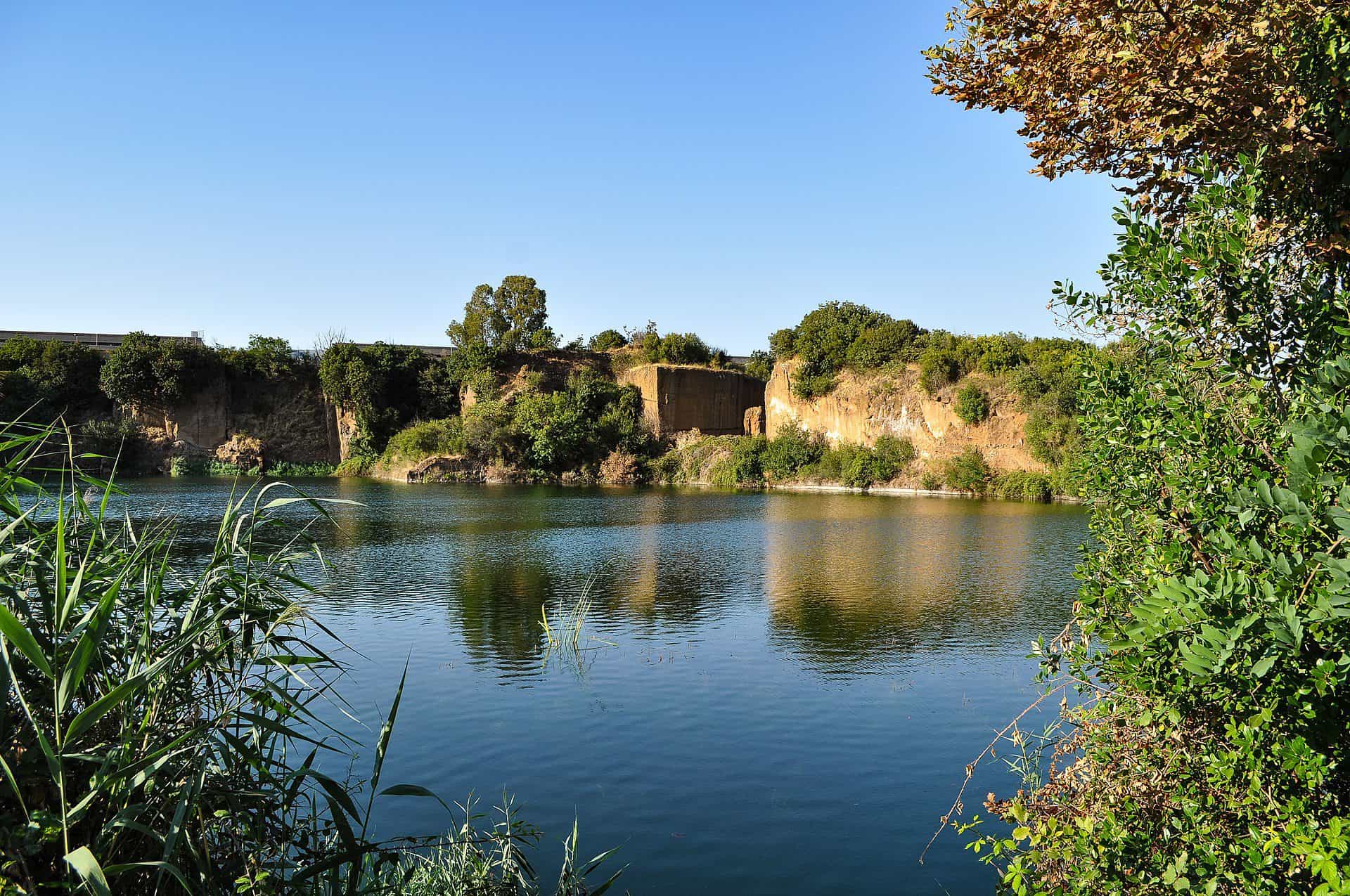
The Cave di Salone, also known as the Latomie di Salone, are ancient tuff quarries dug along Via Collatina, in the eastern quadrant of Rome, between the Grande Raccordo Anulare and the course of the Aniene, in the territory of Municipio V. You reach them from exit 10 of the Raccordo, the one named for Via Collatina, or by driving Via Collatina itself from Rome toward the east. The A24 Roma-L'Aquila-Teramo motorway runs parallel a little to the north, and from the roadway you can see the walls cut into the tuff with the naked eye. They are not an archaeological park, they have no ticket office, no opening hours and no official entrance. The quarry fronts and the water basins formed in the abandoned excavations lie for the most part on private land, occupied by warehouses, depots, sport fishing facilities and commercial businesses. Anyone who arrives here expecting a visitable site with a marked route will be disappointed. Anyone who arrives knowing what they're looking at sees one of the most impressive ancient industrial landscapes of the whole Roman area.
A premise that comes before everything else, because it concerns the safety of people and not the curiosity of the traveler: the water basins of the Cave di Salone are not bathing waters. They are not classified, not monitored, not supervised and have none of the characteristics that make a swim safe. They are flooded quarries, with walls that drop straight down below the water line, bottoms that fall away without warning and temperatures that plunge a few centimeters below the surface. Where the land is fenced and signs forbid entry, going in means trespassing on private property and getting into a situation from which, in case of trouble, rescuers have difficulty arriving. In this guide you won't find a single line inviting you to swim at the Cave di Salone: it's not something that can be recommended to anyone.
That said, the place deserves to be told in full. A huge part of the stone Rome was built with came out of here. A few hundred meters from these quarry fronts spring the sources that still feed the Trevi Fountain today. Under the fields you see from the overpass run the tunnels of an aqueduct inaugurated in 19 BC and never completely abandoned since. And the ground around has yielded protohistoric necropolises that changed what we know about Latium before Rome. For the urban stretch of the Aniene, protected and equipped, the reference page is the one on the Aniene Valley Nature Reserve.

Where the Cave di Salone are and how to get there
Salone is one of the areas of the eastern Agro Romano. It takes its name from an estate that at the beginning of the 19th century measured 615 rubbia, more than 1,100 hectares, and bordered the Aniene and the estates of Rustica, Ponte di Nona, Cerrone, Benzoni, Torragnola, Torrenova, Tor Sapienza, Casetta and Tor Tre Teste. These are the names you read today on the road signs of the eastern quadrant, and it's useful to keep them in mind: the landscape of the Cave di Salone only makes sense if you look at it as the remnant of an enormous countryside devoured by 20th century building.
By car to the Cave di Salone
The simplest way is the Grande Raccordo Anulare, 68 kilometers of ring road run by ANAS with 44 interchanges, of which 33 are numbered. Exit 10 is the one for Via Collatina, 11 the one for Via Prenestina, and 9 feeds onto the A24. From Via Collatina you proceed east, outside the Raccordo, and the road crosses the Salone district. Coming from the center you can take Via Collatina all the way up: the modern road begins at Via Prenestina near Villa Gordiani and ends at the castle of Lunghezza, following the ancient route in places.
A warning: Via Collatina on this stretch is a working road, narrow, with trucks, blind curves and nonexistent shoulders. It is not a scenic road and you shouldn't crawl along it to enjoy the view, because there's always a heavy vehicle behind you. If you want to stop, find a legitimate pull-out first, off the roadway, and get out only if the spot is safe.
Cave di Salone by public transit and on foot
The area is served by surface public transit and by the railway stations of the line that runs toward Tivoli, but routes and frequencies change often and should be checked on the same day on the transit company's website and in the official train timetable. A practical rule applies: you don't come here by chance and you don't come late. After sunset the district empties out, the public lighting is patchy and walking along the roadway becomes dangerous.
The sensible walk, for anyone who wants the river and not the quarry front, is further downstream, inside the protected stretch of the Aniene: from the Cervelletta to the Parco delle Valli, where the river flows into the Tiber, the route is equipped, well used and makes sense even with family. The Cave di Salone, instead, are observed from the outside, from public points, and photographed from there.
The context: Municipio V, GRA, A24
Three pieces of infrastructure decided the fate of the Cave di Salone more than any urban planning choice: the Raccordo, completed in 1970 with the opening of the last stretch on September 16, the A24 motorway with its 7.3 kilometer urban penetration between the Tangenziale Est and the Raccordo, opened to traffic in June 1990 on the Roma Casal Bertone-Roma Tangenziale Est stretch, and the railway to Tivoli. The result is that the ancient quarry, which for 20 centuries had been a place of work reachable from the river, found itself wedged into a knot of interchanges and warehouses. The landscape you see is the product of this overlap, and should be read as such.
Safety at the Cave di Salone: why you don't swim here
A quarry pond looks like a lake and has almost none of the properties of one. It forms when the excavation goes below the water table level and water fills the void left by the removed material: the shape of the basin is that of the cut, not that of a natural hollow. This means vertical walls, sudden drops from a few centimeters to many meters, debris and submerged structures left on the bottom, banks that collapse because they are excavation fronts and not beaches. The water is still, often stratified: at the surface it warms in the sun, just below it stays cold all year, and the sudden passage between the two layers is one of the classic causes of accidents in unsupervised waters.
What the rules say about bathing waters
The European directive 2006/7/EC, the one that regulates the matter across the Union, defines bathing waters as surface waters where the competent authority expects a large number of bathers and for which it has not imposed a permanent bathing ban or issued a permanent advice against bathing. These are waters identified every year, subject to a monitoring calendar fixed before the season, sampled at least four times per season at intervals of no more than a month, classified as poor, sufficient, good or excellent, and signposted to the public with signs on site and online publication. A basin that doesn't appear in those lists is not a place where swimming is allowed and unchecked: it's a place that is not considered swimmable at all.
The Cave di Salone fall into this second category. Nobody takes samples, nobody publishes a classification, no sign informs about water quality, no lifeguard watches the shore. The practical consequence is blunt: here you don't swim, you don't dive from the quarry front, you don't bring an inflatable boat, you don't let a child go near the shore.
Private property, fences and signs at the Cave di Salone
A large part of the quarry fronts and bodies of water falls within private, fenced areas, with productive or sports uses. Where there is a fence, a gate or a no-entry sign, that is the boundary and there is no room for interpretation: climbing over means trespassing on someone else's property, and in the case of a disused extraction area it also means setting foot on unstable ground without anyone knowing where you are. Municipal ordinances and measures by the local authorities can introduce further specific bans, and they must be respected as written on the signs posted on site.
If Someone Is in Trouble in the Water
The single European emergency number in Italy is 112. In a quarry basin, rescue is complicated by three factors that you should know beforehand: vehicles often cannot reach the shore, the exact spot is hard to describe because there are no street-number landmarks, and the vertical banks make it impossible to enter and leave the water safely even for those who swim well. Anyone who attempts a rescue by swimming in such a setting, without equipment, in cold water and with overhanging walls, adds a second person in danger to the first. The rule of professional rescuers applies here too: you call for help, you stay visible, you try to help from the shore with something that floats and can be extended, you do not go in.
A Verdict Without Beating Around the Bush
On this point our opinion is clear: the Cave di Salone are a magnificent subject to look at and to photograph, and a terrible place to use as a swimming pool. The allure of the little green lake among the red walls is real, and precisely for this reason it must be said clearly that this allure has nothing to do with safety. Anyone who wants to swim outdoors near Rome has equipped, supervised and monitored alternatives. This is not one of them.
The Tuff of the Cave di Salone: What Stone It Is and Why It Was Quarried Here
Tuff is the most widespread of the pyroclastic rocks: it forms from the accumulation and then the compaction of the materials expelled during eruptions, lapilli included, that is, fragments between two and 30 millimeters. Lazio is one of the richest regions in Europe in it thanks to two volcanic districts: the Sabatino complex, active between about 600,000 and 300,000 years ago, and the Alban Hills, active between about 600,000 and 36,000 years ago, to which among other things we owe the tufo lionato, the tawny-colored one used in building since the third century BC.
Why the Romans Chose the Tuff of the Cave di Salone
The reason is entirely practical. The Romans began to use tuff as a building material as early as the seventh century BC because it combines two qualities that usually don't coexist: it is resistant enough to hold up imposing masonry and workable enough to be cut into regular blocks with simple tools. In the quarry it is extracted almost soft and hardens in the air after exposure. It weighs little compared with compact dressed stones, and this, in an age when transport was the greatest cost, was worth as much as resistance.
How a Block Was Cut at the Cave di Salone
The ancient method can still be read on the walls today. They worked in steps, isolating the block on three sides with vertical grooves made with a narrow-pointed pick, then the block was detached from the bottom with wedges. The result is the fluted vertical wall that characterizes all the latomiae of the Mediterranean, and that at the Cave di Salone can be seen in several spots, together with the cavities and caverns that tunnel excavation left behind. Those caves are not natural: they are the negative of the stone carried to Rome.
Why the Landscape of the Cave di Salone Looks Like a Cut Mountain
The quarry front presents itself as a succession of hills broken by overhanging walls of reddish tuff, pierced by caverns of very different sizes, some as small as a room, others able to hold a shed. During the 20th century those cavities were adapted to the most varied uses, from storage to workshops. It is a hybrid landscape, half ancient and half industrial, and it has no equal in the immediate Roman outskirts.
Lucullus, the Lucullan Land and the Latomiae of Salone
The name that the scholarly tradition links to these quarries is that of Lucius Licinius Lucullus, born in 117 and died in 56 BC, Roman general and politician. His military career took place in the East: he fought under Sulla in the Social War and in the First Mithridatic War, was consul in 74 BC and led the campaign against Mithridates VI, winning at Cabira and before Tigranocerta, before being replaced by Pompey in 66 BC by virtue of the lex Manilia. The triumph was granted to him only in 63 BC, after long political resistance.
What interests us here is what came next. From the eastern conquests Lucullus came back with an enormous fortune, which he invested in properties, villas and enterprises: the villa at Tusculum with its library open to Greek intellectuals, the one in Naples with fishponds and landings, the gardens on the Pincian Hill that the Romans called horti Lucullani. His name has remained in the Italian language through the adjective luculliano, which still today indicates an immense meal, and in the line handed down by the ancients, when the servant was amazed at the table laid for the master alone: today Lucullus dines with Lucullus.
The Lucullan countryside and tuff for Rome
Local tradition, also taken up by modern sources that describe the Latomie di Salone, attributes to Lucullus the start in the 1st century BC of the systematic exploitation of the tuff quarries of this stretch of the Aniene valley, with the blocks lowered onto rafts and carried to Rome along the river. For fairness it must be said that the attribution belongs to local historiographic tradition more than to an explicit ancient document, while the existence of the agro Lucullano as a name for the territory of the springs is attested by the sources on the aqueduct. The substance, however, doesn't change: the latomie of Salone worked for centuries and their material ended up in the construction sites of the Urbs.
The Aniene, the conveyor belt of the Cave di Salone
The Aniene is 98.5 kilometers long, rises in the Simbruini Mountains on the border between Lazio and Abruzzo from two branches, the Aniene proper with its source at 1,200 meters above sea level on Monte Tarino and the Simbrivio coming down from Monte Autore, and brings to the Tiber an average of about 31 cubic meters per second. It is the second left tributary of the Tiber after the Nera. A river like that, with a regular flow and a course passing a few tens of meters from the quarries, was the cheapest way to move heavy stone: the rafts came down with the current to Rome, where the load was unloaded at the river landings. Without that river, the Cave di Salone would have remained a local resource, and the building history of Rome would be different.
From the tuff of Salone to the monuments of Rome
The material extracted here was used for centuries in the city's most important construction sites, the Colosseum included. Anyone visiting the Flavian amphitheater almost always looks at the outer travertine and forgets the rest: the masonry machine that holds up the seating is made in large part of tuff blocks and of Roman concrete pours with volcanic aggregates. Tuff occupies the part of the monument that doesn't get photographed, and without that part the monument that does get photographed wouldn't exist.

The Acqua Vergine begins next to the Cave di Salone
On June 9, 19 BC, Marcus Vipsanius Agrippa, son-in-law of Augustus and the man who built more than anyone else in Rome, inaugurated the aqueduct that bears the name Aqua Virgo. It served to feed his baths in the Campo Marzio, the city's first great public bath complex. The intake was just before the eighth mile to the north of Via Collatina, in the area of the springs fed by the Aniene water system, at about 24 meters above sea level: we are exactly here, in the Salone district.
20 kilometers and four meters of drop from the Cave di Salone to the center
The numbers of the work are impressive even today. The aqueduct is 20.5 kilometers long, equal to about 12 and a half miles, runs almost entirely underground except for the last 1,800 meters, partly on arches, and loses in all four meters of elevation from intake to arrival. Four meters over 20,000: an average slope of 20 centimeters per kilometer, kept constant by digging tunnels by hand, with service shafts and water levels. The flow was on the order of 100,000 cubic meters a day. Anyone who works with reinforced concrete and lasers knows how hard it is to hold a slope like that over that distance: here it was done in the 1st century BC.
Why it's called Vergine
The tradition reported by the ancients says that a young girl pointed out the spring to thirsty soldiers, and that from that episode the source took the name Aqua Virgo. It is an aetiological legend, that is, a story built to explain a name, and should be taken for what it is. The name, in any case, has lasted 2,000 years and reached the maps of the modern aqueduct.
The water of Salone in the fountains of the center
The story of the Aqua Virgo doesn't stop with antiquity. Restored by Tiberius in 37, put back in working order by Claudius between 45 and 46 after the damage caused by the removal of material ordered by Caligula, repaired by Pope Hadrian I in the 8th century and put back into operation by Nicholas V in 1453, it became the Acqua Vergine of the popes, then split into Vergine Antica and Vergine Nuova, the latter built in the 1930s as a pressure system. Today the water that arrives from the Salone area feeds the Trevi Fountain, the Barcaccia in Piazza di Spagna, the fountains of Piazza del Popolo below the Pincian Hill and the one in front of the Pantheon, besides many others.
It's worth pausing for a moment on this chain. The water that tourists photograph as it falls into the Trevi basin starts from a piece of countryside wedged between warehouses and interchanges, about 10 kilometers away, and arrives by gravity along a route designed under Augustus. It is the most extraordinary thing about the Cave di Salone, and no sign says so.
Before Rome: Collatia, Caenina and the protohistory around the Cave di Salone
The territory between Via Tiburtina and Via Collatina, on both sides of the Aniene, has yielded substantial traces of settlements of the Italic peoples going back to protohistory. This is not an erudite detail: it is the reason why this stretch of countryside, today reduced to an industrial backyard, appears in manuals of Latium archaeology next to far more famous sites.
Collatia, the city of Lucretia
Collatia was a city of the Latium vetus at the end of Via Collatina. Archaeological investigations of recent decades have identified its site in the Rustica district, where stretches of walls in squared tuff blocks have emerged, datable between the late Archaic period and the Republican age. Tradition had it founded as a colony by King Silvius of Alba Longa. Under Rome, King Tarquinius Priscus took it from the Sabines and set his nephew Egerius there as governor. From Collatia came Lucius Tarquinius Collatinus, first consul of Rome together with Lucius Junius Brutus and husband of Lucretia: the violence suffered by Lucretia at the hands of Sextus Tarquinius and her death, which according to the ancient account took place precisely at Collatia, were the spark of the revolt that overthrew the monarchy. The grammarian Sextus Pompeius Festus derived the name from conferre, because the city was supposed to have gathered the resources of the abandoned settlements of the region.
The necropolises of Rustica next to the Cave di Salone
In 1972, at the start of work on the motorway, a necropolis of about 300 tombs datable between the 8th and 3rd centuries BC came to light in this area, with grave goods that were rescued at the last moment from clandestine digging. Professor Lorenzo Quilici then hypothesized that the adjacent protohistoric settlement was ancient Caenina. Later excavations, which brought to light an even larger necropolis and the remains of a settlement, shifted the identification to Collatia. Near Rustica, 418 pit tombs were brought back to light, uncovered in 2009. Since December 2015 the materials from those excavations have been displayed in a dedicated room of the Museo nazionale romano. Anyone who wants to understand what was here before the quarries should start from that room, and then come see the ground.
Caenina, Acron and the rape of the Sabine women
Caenina was one of the oldest settlements of Latium vetus and its inhabitants were called Caeninenses. Its remains have never been identified with certainty on the ground: Antonio Nibby proposed the Marco Simone estate, other readings place it along the Aniene, about 10 kilometers from the confluence with the Tiber and three from Monte Sacro, in the area that today corresponds to Ponte Mammolo. The ancient story links it to the rape of the Sabine women: during the Consualia organized by Romulus the foreign women were abducted, and Caenina allied with Antemnae, Crustumerium and the Sabines against Rome. King Acron challenged Romulus to a duel, was killed, and Romulus took the city at the first assault. The weapons of the enemy were dedicated to Jupiter Feretrius on the Capitoline as spolia opima, an honor granted only three times in all of Roman history, to Romulus, to Aulus Cornelius Cossus and to Marcus Claudius Marcellus. The sources are Livy, Dionysius of Halicarnassus, Plutarch and Diodorus Siculus, who go back to the collection of Quintus Fabius Pictor.
The Osteria dell'Osa and Gabii, a Little Farther East
Continuing east, along Via Prenestina, you meet another chapter of the same story. Gabii stood at the 12th mile of the Prenestina, about 20 kilometers from Rome, near a volcanic lake now dried up that the sources called lacus Buranus or lacus Sanctae Praxedis. Its quarries supplied lapis gabinus, an excellent building stone. The excavations of Gavin Hamilton, begun in 1791, brought to light the forum and more than 200 statues, 49 of them restored. The protohistoric necropolis of Osteria dell'Osa, connected to that settlement, yielded between 600 and 700 burials datable from the ninth to the sixth century BC, one of the richest documentations that exist on Latial society before Rome. The Cave di Salone and these sites belong to the same historical landscape, and it makes sense to read them together.
A Curiosity About Cave di Salone
The place name Salone is almost certainly the result of a mistake. Studies of the territory hold that it derives from an erroneous transcription of the original Solone, a name that the medieval farmstead bore in the Latin form Campus Solonis, attested alongside the other name Castellum Ulmetum. Behind that name is a juicy scholarly tradition: Solon, the Athenian lawgiver, according to an ancient legend visited Rome in the sixth century BC, and the memory of his passage would have settled in this corner of countryside along the Collatina.
From there on, imagination worked overtime. In the 19th and 20th centuries the peculiarity of the place, with those squared-off walls and those galleries that vanish into the dark, fueled conjectures about underground cities and hypogean civilizations, and someone linked the name of Solon to the search for a site tied to the vanished Atlantean society, a theme that Plato precisely traces back to Solon in the Timaeus and the Critias. These are hypotheses without any archaeological evidence: they should be told the way the legends of a place are told, that is, by pointing out that they are legends.
The real curiosity, the documented one, is another and lurks in the same word. The name Salone still indicates today the stretch of countryside where the Augustan aqueduct has its intake: the place name and the source of the Acqua Vergine coincide, and that name born perhaps from a copying error ended up on one of the oldest infrastructures still functioning in Europe. At the Cave di Salone history always works like this: what seems a marginal detail turns out to be the center of the matter.
From Medieval Farmstead to Neighborhood: The Long History of the Cave di Salone
With the ancient age over, the territory does not empty: it changes owner. The farmstead of Salone is documented from the 11th century under the names Campus Solonis and Castellum Ulmetum, and in 1074 it appears confirmed to the basilica of San Paolo fuori le mura. It later passed to the Liberian basilica, that is, to Santa Maria Maggiore, and in the 16th century it ended up with Cardinal Agostino Trivulzio, who had a villa built there with work attributed to Baldassarre Peruzzi and Daniele da Volterra. In 1527 the Landsknechts who had sacked Rome plundered this estate too. Afterward the property returned to the chapter of Santa Maria Maggiore. At the beginning of the 19th century the estate measured 615 rubbia, more than 1,100 hectares.
The Domuscultae and the Country Castles Around the Cave di Salone
In the centuries after the devastations of the invasions, the agrarian landscape around the Cave di Salone reorganized around the great ecclesiastical estates, the domuscultae, and then around the fortified farmsteads of the Roman families. In the 13th century the barons de' Rusticis had the tall tower of the Rustica built, which gave its name to the neighborhood. The fragmentation of properties that followed multiplied the small rustic castles, and some of those fortified farmsteads can still be seen, wedged between the warehouses, often unrecognizable to anyone who doesn't know what they are looking for.
The Roman Rustic Villas Buried Under the Warehouses
Rustic villas of the Republican and Imperial age were built in great numbers in this territory rich in water and favorable to agricultural and pastoral activities, and very few visible traces of them remain. The 20th century swept the board clean: warehouses, houses, shacks, depots, and in some cases illegal buildings have covered patches of landscape that had been preserved intact for centuries. When you find a fragment of that countryside surviving around a medieval farmstead, you are looking at an exception, not the rule.
The castle of Lunghezza and the end of the Collatina
The modern Via Collatina ends at the castello di Lunghezza, which ideally closes the route that began at Villa Gordiani. In between, from Rome to Lunghezza, the road crosses the Collatino with the Boccaleone farmstead at the sixth mile, Rustica with its finds inside the Raccordo, Salone with its quarries, and further out Ponte di Nona. A stretch of the ancient road, brought to light in 2008 during work near the shopping center in east Rome, turned out to be in an excellent state of preservation, better even than that of the best-known stretches of the Appia. Other stretches are visible in Parco Fabio Montagna, partly reburied and partly left in view.
Something nobody tells you about Cave di Salone
Almost everyone who looks for information about the Cave di Salone starts from a misunderstanding: they believe it's a public area, a kind of wild park where you can freely slip in. It isn't, and it's worth explaining why properly, because the confusion comes from a true fact.
The true fact is that a little further downstream there really is a protected area: the Aniene Valley Nature Reserve, 650 hectares along the urban course of the river, run on behalf of the regional body RomaNatura by the association Insieme per l'Aniene, founded in 1999. The reserve starts from the Grande Raccordo Anulare and reaches the confluence with the Tiber, where the Parco delle Valli opens, and crosses nine urban areas: Rustica, Tor Cervara, Tor Sapienza, Colli Aniene, Ponte Mammolo, Casal de' Pazzi, Pietralata, Monte Sacro and Trieste. Inside its perimeter you find the wetland of the Cervelletta, the riparian strip of the river and the Parco delle Valli itself, with papyrus, irises, elders and algae, brown trout, crabs, frogs and American crayfish.
The Cave di Salone, however, remain outside: they are beyond the Raccordo, in an area where landscape protection doesn't translate into an equipped park and where ownership is overwhelmingly private. The paradox is all here. A few hundred meters away you go from a system of protected areas with volunteers, guided tours, biodiversity monitoring projects and signage, to a district where none of the three things a visitor takes for granted exist: an entrance, a written rule, someone to ask.
The practical consequence, which nobody ever writes plainly, is this: you don't enter the Cave di Salone. You look at them from outside, from public points and from the roads, you study them on maps and aerial photos, you tell their story. If one day part of the district is acquired and made safe, and the recovery projects discussed over the years go in that direction, then there will be a path, signage and someone in charge. Until that day, the correct answer to the question of how to visit the Cave di Salone is that you don't, and anyone telling you otherwise is sending you onto someone else's property.
The advice I give you for visiting Cave di Salone
The most useful advice is to change the very idea of a visit. The Cave di Salone aren't walked, they're read. To read them you need to arrive prepared, stay on public roads and know in advance what you're looking at. Here is how to organize half a day in this quadrant.
First, the order. You start from the Museo nazionale romano, to see the grave goods of the quadrant's necropolises and understand what it meant to live here in the 8th century BC. Then you come to the site, with that image in your head. The reverse order doesn't work: on the ground, without context, you only see a cut hill behind a fence.
Second, the time. The best light is mid-morning in autumn or spring, when the low sun lights up the red of the tuff and the shadows of the galleries turn black. In summer, at noon, the quarry front flattens out and becomes unreadable, besides being an oven. In winter, after rain, the road fills with mud and the trucks pass anyway.
Third, the vehicle. Here the car is almost mandatory, but it should be used as a base and not as a viewpoint: you park where it's lawful to do so, you get out, you look, you get back in. Stopping on the roadway of a heavy traffic road is the most effective way to turn an outing into a fine, or worse.
Fourth, and most important of all, the perimeter. You don't climb over, you don't enter the private yards, you don't go near the edge of the water basins, you don't explore the galleries. The tuff of the abandoned latomie crumbles, the edges are unstable and small collapses are normal in a quarry front that is no longer maintained. The place is as fascinating as you like, but it doesn't reward those who treat it badly.
Frequently asked questions about Cave di Salone
Where exactly are the Cave di Salone?
The Cave di Salone are in the eastern quadrant of Rome, along Via Collatina, between the Grande Raccordo Anulare and the course of the Aniene, in the area that bears the name Salone, in the territory of Municipio V. Exit 10 of the Raccordo is the one for Via Collatina, the reference point for getting there.
Can you visit the Cave di Salone?
No, the Cave di Salone aren't visited in the sense in which you visit an archaeological site: there is no entrance, ticket office, hours or organized routes. The area is largely occupied by warehouses, depots and buildings, some built without permits, and it has to be read from the public roads, knowing in advance what you're looking at, without going into private land.
Can you swim in the ponds of the Cave di Salone?
No, you don't swim at the Cave di Salone. A quarry pond looks like a lake but has almost none of the properties of one: the shape of the basin is that of the excavation cut, not that of a natural hollow, with vertical walls, sudden drops from a few centimeters to many meters and debris or submerged structures on the bottom. Staying on the public roads is the main safety rule.
Are the Cave di Salone suitable for an outing with children?
No, with small children the Cave di Salone are not a suitable destination: there are no continuous sidewalks or protected spaces, the traffic is heavy and there are unfenced bodies of water everywhere. For a day outdoors with the family in the same quadrant the reasonable choice is the equipped stretch of the Aniene Valley Nature Reserve, with the Cervelletta and the Parco delle Valli.
Why are the Cave di Salone important historically?
The Cave di Salone are important because this is where the Romans extracted tuff, the volcanic rock with which a large part of ancient Rome was built. A city of a million inhabitants in the Imperial age needed a system of extraction and transport comparable to modern heavy industry, and the latomie of Salone are one of the scars that activity left on the territory. The aqueduct of the Aqua Virgo also began in this area, inaugurated by Agrippa on June 9, 19 BC.
What is the best time to photograph the Cave di Salone?
The best time for the Cave di Salone is autumn, from mid-October to the end of November, and spring before the heat explodes, from mid-March to the end of April. In those weeks the light is low, the vegetation doesn't yet hide the walls and the air is clear enough to see the Colli Albani in the background. Avoid summer days between 11:00 and 16:00, when the vertical sun flattens the quarry front.
What is the right photo to take at the Cave di Salone?
The right photograph at the Cave di Salone is not the one of the green pond, but the one of the wall: the vertical cut of the tuff with the dark mouths of the galleries. It works for the very strong contrast between the lit reddish surface and the solid black of the cavities, as well as for the regular geometry of the excavation fronts, elements that are rarely found together in a single shot.
Fifth, the road companion. If you really want to get into this piece of Rome, go with someone who knows how to tell its story. The area has no panels, no visitor center and doesn't forgive improvisation: a licensed tour guide who knows the east quadrant changes the experience completely, and anyone organizing group outings or itineraries off the classic circuits finds the right contacts among the professionals of TourLeaderPro a Roma.
To close the chapter, a clear opinion: the Cave di Salone are not an outing for everyone. They are an extraordinary stop for those who love the archaeology of labor and the industrial landscape, and a guaranteed disappointment for those looking for a pretty place to spend Sunday. Knowing in advance which of the two groups you belong to either saves you the trip or makes it memorable.
Another well-known fact, yet rarely cited
That Rome was built with the tuff of its volcanoes everyone knows. What is rarely cited is the logistical consequence of that fact, namely that a city of a million inhabitants in the Imperial age needed a system of extraction and transport comparable to modern heavy industry, and that this system left enormous scars on the surrounding territory.
The Latomie di Salone are one of those scars, perhaps the most legible one left in the Roman area. Every cubic meter of tuff missing from these hills ended up in a wall, a foundation, a vault. There is nothing romantic about the process: it was brutal labor, often servile, carried out with sledgehammer, wedge and pick, in dust and without protection, and river transport to Rome was a trade of its own, with its raftsmen and its landings.
The second part of the fact, cited even less, concerns time. The quarries didn't work for one season: they worked for centuries, in the Republican and Imperial ages, then again in the Middle Ages and the modern era, and in industrial forms well into the 20th century. The walls you see today are a stratigraphy of different techniques: over the ancient stepped cutting are superimposed the regular fronts left by mechanical equipment, and in certain points you can see very clearly where one phase ends and the other begins. Learning to read that difference is the best way to turn a passive visit into an active reading of the landscape.
Third consequence, the one that brings tourists to Rome without anyone telling them: without the quarries of the eastern quadrant, without the river that carried the blocks into the city and without the aqueducts that came down from the same valley, none of the monuments that now queue at the ticket offices would exist. The Colosseum and the great baths are children of this territory as much as they are of the architects who designed them. Anyone planning a trip to Rome who wants to understand this chain, even in English, will find a good starting point in ItalyPlanner's guide best things to do in Rome.
The right photo to take at Cave di Salone
Photography, here, is almost the only legitimate way to take something away. And the right photo is not the one of the green pond: it is the one of the wall.
The strong subject of the Cave di Salone is the vertical cut of the tuff with the dark mouths of the galleries. It works for three technical reasons: the very strong contrast between the lit reddish surface and the solid black of the cavities, the regular geometry of the excavation fronts that gives clean lines in an otherwise chaotic landscape, and the scale, which becomes evident as soon as a known element enters the frame, a truck, a fence, a tree grown on the edge.
How to set up the shot at the Cave di Salone
Work in landscape orientation with a moderate telephoto, between 80 and 150 millimeters full-frame equivalent: perspective compression stacks the steps and conveys the mass of the cut hill. Expose for the lit stone and let the caves go black, without trying to recover them in post-production: the dark hole is the subject, not a mistake. If the sky is white, cut it out almost entirely. A washed-out sky ruins any quarry photo.
The contrast that tells the story of the Cave di Salone
The second image to look for is the contrast between ancient and industrial: the tuff wall with the warehouse, the pylon, the motorway guardrail in front of it. Many photographers avoid it because it dirties the scene. It's exactly the opposite: that visual dirt is the recent history of the Cave di Salone, and it's more honest than a cleaned-up frame pretending to a countryside that no longer exists.
Rules of common sense, and of law
You photograph from a public place, without entering private property and without climbing over. Drones are not to be flown at random: the area is crossed by infrastructure and the national airspace rules apply, which should be checked on the official maps before every flight. And you don't go down to the banks of the basins to look for the best angle: the edge of a quarry basin gives way without warning, and no photograph is worth that risk.
One last professional tip: the light that works best is that of early autumn afternoons, with the sun coming in sideways from the southwest and sculpting the steps. In those conditions even a phone delivers an image worth having.

Some important events that happened here in history
The Salone district has no famous date to show off, it has about 10 less famous and far more interesting ones. Here they are in a row, because together they tell 2,500 years of intensive use of the same piece of land.
June 9, 19 BC
It's the date of the inauguration of the Aqua Virgo by Agrippa. From that day the water of the springs at the eighth mile of the Collatina enters Rome, and it has never completely stopped entering. Few human works can show continuous operation of more than 2,000 years.
37 and 45 AD
Two maintenance dates worth as much as a foundation: the restoration by Tiberius in 37, and the one by Claudius between 45 and 46, made necessary by the removal of material ordered by Caligula. The aqueduct that starts from here survived because someone repaired it, emperor after emperor, pope after pope.
1453
Nicholas V puts the Vergine back into operation, and in the following centuries it will become the aqueduct of the monumental fountains of the center. It is the moment when the countryside of Salone becomes strategic for Rome again after a millennium of semi-abandonment.
1527
The Landsknechts who had sacked Rome also plunder the Salone estate, with the villa built by Cardinal Agostino Trivulzio. The Sack of Rome, for the history books, is a city event. For the Agro Romano it was a thorough devastation of farmsteads and estates, and Salone suffered it fully.
1791 and 1972
Two dates of archaeology. In 1791 Gavin Hamilton opens the excavations of Gabii, a little further east, bringing to light the forum and more than 200 statues. In 1972 the motorway works bring out the necropolis of the 300 tombs between the 8th and 3rd centuries BC, with the grave goods saved by a hair from clandestine digging. Between the two dates lies the whole difference between 18th century antiquarianism and the emergency archaeology of modern construction sites.
September 16, 1970 and June 1990
The completion of the Grande Raccordo Anulare and the opening of the urban motorway stretch leading toward the A24 close the infrastructural encirclement of the quarries. They are the two dates that explain why today the quarry front is better seen from the motorway than from the ground.
2008 and 2009
In 2008 work near the shopping center in east Rome brings to light two sections of the ancient Via Collatina in excellent condition. In 2009 near Rustica 418 pit tombs are uncovered, whose materials have been displayed since December 2015 in a room of the Museo nazionale romano. The territory of the Cave di Salone, in short, keeps giving back its history every time someone digs into it for other reasons.
Who has passed through Cave di Salone
A latomia is not a drawing room and keeps no registers of illustrious visits. The names that can be mentioned, however, are quite a few, and almost all documented by solid sources.
Agrippa and Augustus's engineers
Marcus Vipsanius Agrippa, the general who won at Actium and the builder of the first Pantheon, passed through here in the most concrete sense of the term: the intake of his aqueduct is in this territory, and the choice of the spring, the definition of the elevation and the route were decisions made on the spot by him and his technicians. The Aqua Virgo construction site is the first documentable illustrious presence in the Salone area.
Lucullus, or his shadow
Lucius Licinius Lucullus, the victor over Mithridates, is tied to this territory by the tradition that attributes to him the start of quarry exploitation and by the very name of agro Lucullano that designated the area of the springs. That he himself walked on the edge of these latomie is not stated explicitly by any ancient source: the link is one of property and place names, and it is right to present it that way.
The Tarquins, Lucretia, Collatinus
The story of the origins of Rome passes through here by way of Collatia, identified by recent research in the Rustica area. Lucius Tarquinius Collatinus, first consul with Brutus, came from this city. Here tradition places the violence of Sextus Tarquinius against Lucretia and her death, which opened the way to the expulsion of the kings. This is Roman historiographic tradition, not chronicle, and it should be handled with that caution. But it is the tradition on which the Romans built the very idea of a republic.
Romulus and Acron, according to the ancient account
Still in the register of tradition, the area between the Aniene and the Collatina is the theater of the conflict with Caenina after the rape of the Sabine women, with the duel between Romulus and King Acron and the spolia opima dedicated to Jupiter Feretrius. Livy, Dionysius of Halicarnassus, Plutarch and Diodorus Siculus tell the story going back to Fabius Pictor.
The building popes and their architects
Hadrian I in the 8th century and Nicholas V in 1453 put their hands to the aqueduct that starts from these springs. In the 16th century Cardinal Agostino Trivulzio had the estate's villa built, with work attributed to Baldassarre Peruzzi and Daniele da Volterra, two leading names of the Roman Renaissance. Peruzzi is the architect of the Farnesina and of Palazzo Massimo alle Colonne. Daniele da Volterra is the painter Michelangelo esteemed and whom history unfairly remembers only for the drapery added to the Last Judgment.
Cartographers, engravers and Grand Tour travelers
From the 16th century onward the eastern Agro Romano becomes an object of attention for cartographers, engravers and cultured travelers, who fix its landscape in maps and views. Between 1815 and 1890, every April 21, at the latomie of Cervara, not far from here, the festival of the foreign artists living in Rome was held, a carnival-style event organized by their fraternity. For almost a century, once a year, the tuff quarries of the east quadrant were the merriest place in the city.
The 20th century archaeologists at the Cave di Salone
Among the presences that truly changed what we know of this territory must be counted Lorenzo Quilici, who studied the protohistoric settlement that emerged in 1972, proposing its identification with Caenina, and the teams who from the 1970s onward excavated the necropolises of Rustica and Osteria dell'Osa. It is they who turned a piece of the outskirts into a chapter of a textbook.
Caves, cults and waters: the esoteric side of the Cave di Salone
The artificial cavities left by the excavation had very different uses from storing materials. The local literature on the Latomie di Salone reports three purposes: a prison for people of rank, a place of worship of deities with therapeutic powers, probably tied to the properties of the spring waters of the area, and a site for mystery rites of Eastern origin, in particular the cult of Mithras.
Why a quarry is the perfect place for a mithraeum
Mithraism was a Roman mystery religion derived from the figure of the Persian god Mithra, arisen in the eastern Mediterranean between the 2nd and 1st century BC and spread in the empire from the 1st century AD, with its peak between the 3rd and 4th. It was an initiatory and male cult, popular among soldiers and among administrative cadres, and always a minority in the population. Its places of worship, the mithraea, were natural cavities or caves adapted, or artificial buildings imitating a cave: dark rooms with no windows, able to hold a few dozen initiates for rituals that ended with a communal banquet. A disused latomia offered exactly that kind of space, at no cost and far from prying eyes.
The tauroctony and the seven grades
The central image of the cult was Mithras killing the sacred bull, the tauroctony: from the animal's body sprang the plants and fruits of the earth. The initiatory grades were seven, each associated with a celestial body: Corax, the raven. Cryphius, the bridegroom. Miles, the soldier. Leo, the lion. Perses, the Persian. Heliodromus, the courier of the sun. Pater, the father. The cult disappeared after the Theodosian decree of 391, which banned pagan rites.
How much to believe it
On the presence of Mithraic evidence in the cavities of this district the local literature is affirmative, but the materials and contexts are not documented in an accessible and verifiable scientific publication. The honest wording is therefore this: the general picture is plausible, because cave mithraea are normal in the Roman world and because the area was densely frequented. The specific attribution of a single Salone cave to a mithraeum remains, for now, a tradition to be verified and not an established fact. A similar argument holds for the so-called therapeutic waters: the quality of the springs of the area is documented by the history of the Acqua Vergine, while the healing cult belongs instead to local lore.
The Cave di Salone today: lakes, warehouses and recovery projects
The current state of the district can be described in one sentence: a first-rank historic site reduced to the back lot of an industrial zone. The cavities generated three water basins of artificial origin, around which dining and sport fishing businesses have settled. The rest of the perimeter is occupied by warehouses, depots and buildings of every kind, some built without permits. From the motorway the quarry front remains perfectly visible, and this is the reason so many Romans know it exists without ever having really looked at it.
The decay of the Cave di Salone, told without discounts
This is a place of great history that deserved protection and care much earlier. During the 20th century almost every possible pressure on the Agro Romano landscape was concentrated here: industrial quarrying, productive building, illegal construction, occasional dumping, heavy traffic. The result is a wounded landscape, in which the signs of history survive in patches. Saying it's a shame is the least. Saying it's irreversible would be false, because worse wounds, in other quadrants of Rome, have been stitched back up.
What is moving
In recent years the municipal institutions have started awareness and recovery activities involving the neighborhood's residents, especially the youngest, and in the planning of the eastern area the idea recurs of a broader park of the Aniene linking the green areas of the quadrant. The existence of the Aniene Valley Nature Reserve, with its 650 hectares from the Raccordo to the confluence with the Tiber, shows that a working model already exists a few hundred meters away. Extending it beyond the Raccordo would mean acquiring, making safe and opening: three costly and slow operations, but technically ordinary. For the progress of individual projects it's best to turn to the offices of the Municipio and the regional body that manages the protected areas.
The river, which remains the stone guest
The Aniene suffered heavy pollution in the last century, mostly due to the paper mills working along its course. After those plants closed between the 1970s and 1980s, the fauna typical of healthy rivers has reappeared, brown trout and freshwater crayfish included. It's an encouraging fact that should however be handled with caution, because water quality in the urban stretch varies a lot with the seasons, with rain and with discharges. None of these improvements makes the quarry basins or the river swimmable: they are two different discussions, and should be kept separate.
What to see around the Cave di Salone
The real reason it's worth coming all the way here is that the Cave di Salone are the geographic center of a quadrant full of extraordinary and little-visited things. Here is how to line them up to build a day.
Toward the river and the city
Coming back inside the Raccordo you enter the Aniene Valley Nature Reserve: the farmstead and wetland of the Cervelletta are the natural stop for anyone who wants to walk, and the Parco delle Valli closes the route at the confluence with the Tiber. Further south, on the other great axis of Roman water, the Aqueducts Park shows on the surface what at Salone runs underground: arches, buttresses, channels.
Toward the east, along the Collatina and the Prenestina
The castello di Lunghezza closes the modern Via Collatina. Continuing on the Prenestina you meet the protohistoric necropolis of Osteria dell'Osa and the remains of the city of Gabii, with the sanctuary of Juno Gabina of the late Republican age and the shrine attributed to Domitia Longina, wife of Domitian. Further on still, at Palestrina, the Santuario della Fortuna Primigenia is one of the most imposing complexes of the Roman world, and in the same area are the great bridges of the aqueducts, the Ponte delle Mole at San Gregorio da Sassola and the Ponte Lupo at Gallicano nel Lazio.
Toward Tivoli, at the first motorway exit
The first useful exit of the motorway leads to the Tiburtine area, and there the embarrassment of choice is real: Hadrian's Villa, the Mausoleum of the Plautii and the Ponte Lucano, the urban remains of Roman Tivoli, Villa d'Este, Villa Gregoriana and the Rocca Pia. On the way, the Acque Albule of Bagni di Tivoli tell the other side of Rome's relationship with its waters, the thermal one. A day built like this, starting from the quarries and ending at Tivoli, has a precise logic: you follow the stone and the water in the direction they came from.
Tailor-made itineraries
The east quadrant has no organized circuit and the connections between one site and the next all have to be built: it's the kind of itinerary that needs direction. Anyone working with groups, companies or small private groups who wants a route designed around their own needs can start from the page of TourLeaderPro's professional services. Anyone organizing the trip independently and thinking in English will find useful ideas in the page on day trips from Rome and in the one dedicated to the neighborhoods of Rome.
When to go to the Cave di Salone and when to avoid them
The best period is autumn, from mid-October to the end of November, and spring before the heat explodes, from mid-March to the end of April. In those weeks the light is low, the vegetation doesn't yet hide the walls and the air is clear enough to see the Colli Albani in the background.
To avoid: summer days between 11:00 and 16:00, when the vertical sun kills the relief of the quarry front and the temperature on the yard becomes unbearable. Days of heavy rain and the ones after, because wet tuff is slippery, the shoulders flood and the mud on the roadway makes it hard even to stop. Evening and night hours, in a district that empties out after working hours. On weekends heavy traffic drops a lot, and this makes the drive around more comfortable.
One last seasonal note that concerns safety: in the warm months the temptation to go near the water grows, and with it the risk. The rule stated above applies, with no seasonal exceptions.
Cave di Salone with children and accessibility issues
The opinion is clear: with small children the Cave di Salone are not a suitable destination. There are no continuous sidewalks, no protected spaces, the traffic is heavy and there are unfenced bodies of water everywhere. If the goal is a day outdoors with the family in the same quadrant, the reasonable choice is the equipped stretch of the Aniene Valley Nature Reserve, with the Cervelletta and the Parco delle Valli.
For older kids, the discussion changes: a lesson in geology and labor history given in front of a quarry front is worth 10 pages of a textbook, as long as you stay at the public points and explain well why you don't go near the water. On accessibility, the district doesn't offer routes suitable for people in wheelchairs or with mobility difficulties: uneven ground, gravel, level changes, no crossings. People with accessibility needs find better answers in the equipped parks of the reserve and in the museum sites of the center.
Quick questions about Cave di Salone
Where exactly are the Cave di Salone?
In the eastern quadrant of Rome, along Via Collatina, between the Grande Raccordo Anulare and the course of the Aniene, in the area that bears the name Salone, in the territory of Municipio V. Exit 10 of the Raccordo is the one for Via Collatina.
Can you visit the Cave di Salone?
No, not in the sense in which you visit an archaeological site: there is no entrance, ticket office, hours or routes. The quarry areas and the water basins are largely private and fenced, and are observed from the outside, from public points.
Can you swim in the ponds of the Cave di Salone?
No. They are not bathing waters: they are not classified, not monitored, not supervised. They have sheer walls, sudden bottoms, cold water below the surface and unstable banks. Where the land is fenced and signs forbid access, entering is prohibited.
How much does it cost to enter the Cave di Salone?
There's no ticket because there's no entrance: the district is not a site open to the public. The private businesses operating there each have their own conditions.
Why are they called latomie?
Latomia is the term of Greek origin that indicates an open-air stone quarry obtained by cutting the rock into blocks. The Latomie di Salone are the tuff quarries dug along this stretch of the Aniene valley.
What stone was extracted at the Cave di Salone?
Tuff, the most widespread of the pyroclastic rocks, produced by the accumulation of materials erupted by the volcanoes of Latium. The Romans used it in building as early as the 7th century BC because it combines strength and ease of working.
Is it true that the Colosseum is made with the tuff of these quarries?
The material extracted in the latomie of this territory was used for centuries in Rome's construction sites, and local tradition and descriptions of the site expressly indicate the Colosseum among the destinations. The structure of the amphitheater uses large quantities of tuff next to the travertine.
How did the blocks get to Rome?
On rafts, along the Aniene, which passes a few tens of meters from the quarries and is navigable with light boats in its final stretch. The river was the cheapest means of moving heavy stone.
Do the Cave di Salone have anything to do with the Trevi Fountain?
Yes, directly. The springs that feed the Acqua Vergine, the aqueduct inaugurated by Agrippa on June 9, 19 BC, are in this territory, just before the eighth mile of Via Collatina. That water still feeds the Trevi Fountain and other historic fountains of the center today.
How long is the aqueduct that starts from here?
20.5 kilometers, almost all underground except the last 1,800 meters, with a total drop of only four meters and a flow on the order of 100,000 cubic meters a day.
Are the Cave di Salone inside the Aniene Valley Nature Reserve?
No. The reserve, 650 hectares run on behalf of RomaNatura by the association Insieme per l'Aniene, extends from the Grande Raccordo Anulare to the confluence with the Tiber. The quarries are beyond the Raccordo, outside the protected perimeter.
Are there guided tours of the Cave di Salone?
There is no regular visit service, because there is no visitable site. There are, however, themed itineraries on the eastern quadrant organized by licensed professionals, combining the stops visible from the outside with the archaeological and museum sites of the area.
Are the Cave di Salone suitable for children?
No. Heavy traffic, no continuous sidewalks, unprotected bodies of water and uneven ground make them unsuitable for the little ones. For a day with the family in the same quadrant, the equipped stretch of the Aniene reserve is better.
Are they wheelchair accessible?
No. There are no accessible routes: the ground is uneven, and there are no crossings or equipped parking.
Can you take photographs at the Cave di Salone?
Yes, from a public place, without entering private areas and without going near the edges of the basins. For drones the national airspace rules apply, which should be checked before the flight.
What is the best time of day to see them?
Mid-morning and early afternoon in the in-between seasons, when the low light sculpts the quarry steps. At noon in summer the front becomes flat and unreadable.
What does the name Salone mean?
It most likely derives from a wrong transcription of the original Solone: the medieval farmstead is documented as Campus Solonis and as Castellum Ulmetum. The connection with the Athenian lawgiver belongs to erudite tradition.
Is it true there are underground cities below the Cave di Salone?
No. The galleries and caves you see are excavation cavities, that is, the void left by the stone carried away. The hypotheses about hypogean civilizations and Atlantean connections are 20th century legends with no archaeological support.
Are there really mithraea in the quarries?
The local literature reports the use of some cavities for mystery rites tied to Mithras, a cult that in the Roman world was commonly practiced in caves. The specific attribution of a single cave remains, however, a local tradition, not a published and verifiable fact.
What is the relationship between the Cave di Salone and Collatia?
Collatia, the Latin city homeland of Tarquinius Collatinus and tied to the story of Lucretia, has been identified by recent research in the Rustica area, right next to this territory. The necropolises excavated from 1972 onward belong to that context.
Where can you see the finds discovered around here?
The materials from the 418 pit tombs uncovered in 2009 near Rustica have been displayed since December 2015 in a dedicated room of the Museo nazionale romano.
How much time do you need for a tour of the Cave di Salone area?
For the quarries alone, observed from public points, 40 minutes is enough. For a sensible day, including the museum in the center, the river stretch of the reserve and a stop toward Lunghezza or the Tiburtine area, you need six or seven hours.
Are the Cave di Salone dangerous?
The disused quarry areas are, yes: unstable walls, edges that give way, galleries not made safe, deep and cold water basins. Observed from the public roads they present no risk. Beyond the fence the risk is real and access is forbidden.
What is the difference between the Cave di Salone and the latomie of Cervara?
They belong to the same system of tuff quarries of the Aniene valley. Those of Salone have been preserved relatively better. Those of Cervara, closer to the city, have undergone deeper transformations, and were the setting of the festival of the foreign artists celebrated every April 21 between 1815 and 1890.
The final verdict on the Cave di Salone
It's wise to distrust places that can be summed up in a single photograph. The Cave di Salone are the exact opposite: ugly at first sight, incomprehensible without context, and then able to overturn the idea you had formed of the city. Here are the stone of the monuments, the water of the fountains, the Latin city of the origins and a century of heavy industry, all in the same square kilometer, all without a sign to explain it.
If you come, come with the right mindset: look from outside, stay on the public roads, keep away from the water and take away a reading of the landscape instead of a stunt. And if you happen to pass in front of the Trevi Fountain on the same trip, stop a second longer than usual: that water comes from here, and it is the most beautiful thing the Cave di Salone still have to give to Rome.
Article written by the editorial team of TourLeaderPro, contact them for Private/Corporate/V.I.P. Tours and Experiences.
Planning a trip to Rome? The English-language guides to visiting the city are on ItalyPlanner.com.