The most convenient hill towns in Lazio from Rome are in the Castelli Romani, reachable in 40-60 minutes by Metro Line A and Cotral bus, and in Ciociaria, a little over an hour from the A1 highway. This guide covers fifteen towns with elevation, transport, entrance costs and points to check. For more destinations nearby, see our day trips near Rome page.
Hill Towns in Lazio in the Castelli Romani
The Castelli Romani are the group closest to the capital. Three towns can be reached without a car and explored on foot. Here are the details from our town pages.
Rocca di Papa
Take Metro Line A to Anagnina, then a Cotral bus, which stops at Piazza della Repubblica. From central Rome it takes a little under an hour. The old town climbs from about 700 to 900 meters, with steep stairways and alleys, so wear comfortable shoes. Entering the town is free. You only pay for the ticket to Museo Geofisico dell’INGV, at the top.
Ariccia
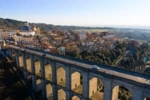
Ariccia is about 30 kilometers south of Rome, along the Appian Way. By car it is roughly 40 minutes from the Raccordo ring road. By public transit, take the Cotral bus from Anagnina and get off in the center after a little over half an hour. Walking around Piazza di Corte costs nothing. A ticket is needed for Palazzo Chigi: hours and prices are on the palace’s official website and vary by season.
Marino
Marino is about 20 kilometers from Rome, at 389 meters at the highest point of the center. The train is the simplest option: the FL4 from Termini reaches Marino Laziale in 37 minutes on average, with one train an hour per branch. A ticket from Termini to Albano costs €2.10, and Marino costs no more. From the station to the center is a ten-minute uphill walk.
Hill Towns in Lazio in Ciociaria
Ciociaria is reached by the A1 toward Naples. Two towns share the Anagni-Fiuggi exit.
Anagni
It takes a little over an hour from Rome. Exit at Anagni-Fiuggi, and about ten kilometers of provincial road lead to the upper town, at 424 meters. If you don’t drive, get off at Anagni-Fiuggi station on the Rome-Cassino line, with departures from Termini, and continue by local bus toward the center. Regional buses also run from Anagnina: schedules change often and should be checked on the operator’s website. The town is explored on foot.
Fiuggi
Fiuggi is a little over an hour from Rome. From the Anagni-Fiuggi exit, take regional road 155 for about 20 kilometers up to just under 800 meters in the Monti Ernici. The town has two parts: Fiuggi Città, the medieval village at 747 meters, and Fiuggi Fonte, the twentieth-century spa district at about 621 meters. By train, get off at Anagni-Fiuggi and continue by bus.
Hill Towns in Lazio in the Monti Lepini
Three towns in the Lepini mountains have different access routes: two from Colleferro station, one from the line to Formia.
Segni
Segni sits at 668 meters, about 60 kilometers southeast of Rome. The polygonal walls, a little over five kilometers long, can be walked freely, with no ticket and no set hours. Museo Archeologico Comunale, at via Lauri 1 (phone 06 97260072), is open Tuesday, Friday, Saturday and Sunday from 9 a.m. to 1 p.m. and from 3 p.m. to 7 p.m. By train, get off at Colleferro-Segni-Paliano; by car, exit the A1 at Colleferro.
Carpineto Romano
The town is about 60 kilometers southeast of Rome, at around 550 meters. By car, exit the A1 at Colleferro and take Strada Regionale 609 Carpinetana. By public transit, the useful station is Colleferro-Segni-Paliano, on the FL6, followed by an intercity bus. Check schedules on the Cotral website or at the toll-free number 800 174 471. The main museum is La Reggia dei Volsci.
Sezze
Sezze is about 90 kilometers from Rome, on a spur of the Monti Lepini above the Pontine Plain. The train stops at Sezze Romano, on the Rome-Formia-Naples line, but the station is at Sezze Scalo, down on the plain. To reach the old town you need the city bus, COTRAL intercity buses or a taxi: you can’t walk up from the railway. Visiting the town is free.
Hill Towns in Lazio in the Aniene Valley
To the east, beyond Tivoli, the towns climb the Monti Lucretili and Monti Ruffi. For Tivoli itself, see also our guide Tivoli Day Trip from Rome: Hot Springs, Villa d’Este and Hadrian’s Villa.
San Polo dei Cavalieri
The town is at 651 meters, about 30 kilometers northeast of Rome and about ten above Tivoli. There is no ticket: you enter on foot through the gates and can wander at any hour. Castello Orsini-Cesi-Borghese is private property and has no regular hours: it opens for events and special openings, so contact them before going up. By car, exit the A24 at Tivoli.
Canterano
Canterano has a little over 350 residents and sits at 602 meters in the Monti Ruffi. It is about 60 kilometers from Rome: exit the A24 at Vicovaro-Mandela, follow the Tiburtina Valeria toward Subiaco and climb along the provincial road. With traffic, allow a good hour. By public transit, the base is the Cotral bus Rome Ponte Mammolo-Subiaco, then local runs: schedules are on the Cotral website.
Hill Towns in Lazio in Tuscia
North of Rome, Tuscia has tuff and hilltop villages, both with free entry.
Calcata
Calcata Vecchia is at 217 meters and has a little over 900 residents between the old fortress and Calcata Nuova. It is a little under 50 kilometers from Rome, about an hour by car from the Raccordo, toward Cassia bis or Flaminia. Leave the car in the public parking lot and walk down for five minutes to the only gate. The old town has no ticket office. Public transit connections are inconvenient.
Vallerano
Vallerano has about 2,400 residents and sits at 390 meters on Monte Cimino, in the province of Viterbo. By car, exit the A1 at Orte and continue on state road 204 Ortana: allow one hour 20 minutes to an hour and a half. For the Chestnut Festival (Festa della Castagna) and the visitor offices, the reference address is piazzale Armando Diaz 13. For options without a car, check the town page and the official schedules.
Coastal Hill Towns in Lazio
On the sea, three destinations combine an old town with archaeology. For swimming, see also lakes near Rome for swimming.
Anzio
Anzio is a little under 60 kilometers away by road. The train is the option our page recommends: the FL8 leaves from Termini and arrives at the station in about an hour, ten minutes on foot from the port. Museo Civico Archeologico and Museo dello Sbarco are inside Villa Adele, at via di Villa Adele 2 (phone 06 98499427), and admission is free at both. Hours differ between winter and summer: check before you go.
Ardea
Ardea is about 40 minutes from Rome: from the Raccordo take via Laurentina and continue for about 30 kilometers. The old town sits on a tuff cliff above the Fosso dell’Incastro, while the coast stretches about ten kilometers between Marina di Ardea, Tor San Lorenzo and Lido dei Pini. Museo Giacomo Manzù is on via Laurentina at kilometer 32. Cotral buses leave from the Laurentina terminus of Metro Line B.
Minturno
Minturno is at the far south of the province of Latina, on the border with Campania. It has its own station, Minturno-Scauri, on the Rome-Formia-Naples line, close to the sea. By car, exit the A1 and take SS7 Appia. The Minturnae archaeological area has its entrance on via Ferdinando II di Borbone (phone 0771.680093): check the full hours before leaving.
How to Choose Among Hill Towns in Lazio
Start with how you’ll travel. If you don’t drive, Marino, Anzio, Anagni and Minturno have a train station in the town or close by. Rocca di Papa and Ariccia can be reached by Cotral bus from Anagnina. Calcata, Canterano, Vallerano and Carpineto Romano are easier by car.
Then check elevation and terrain. Rocca di Papa is steep, Canterano sits at 602 meters, Segni at 668. Even when the town is free, museums and castles have their own rules: the castle at San Polo dei Cavalieri opens only for events. For higher-altitude destinations, see our guide to mountains near Rome.
Always check Cotral schedules the day before: on many town pages the runs change between weekdays, Saturdays and holidays, and in some cases there are few.
| Town | Transport listed on the town page |
|---|---|
| Marino | FL4 from Termini, 37 minutes |
| Anzio | FL8 from Termini, about an hour |
| Rocca di Papa | Metro Line A and Cotral from Anagnina |
| Anagni | Train to Anagni-Fiuggi, then bus |
| Calcata | Car, about an hour |
FAQ About Hill Towns in Lazio
Which hill towns in Lazio can you reach by train?
Our town pages list Marino with the FL4 and Anzio with the FL8, both from Termini. Minturno has Minturno-Scauri station. Anagni, Fiuggi, Segni and Carpineto Romano require a bus after the train.
Which town is closest to Rome?
Among the towns in this guide, Marino in the Castelli Romani is the closest, about 20 kilometers from the center. Ariccia is about 30 kilometers away, and Ardea takes about 40 minutes by car.
Which towns have no entrance ticket?
The town center is free to visit at Rocca di Papa, Ariccia, Segni, Sezze, Calcata and San Polo dei Cavalieri. Museums and palaces have their own rules, for example Palazzo Chigi in Ariccia.
Which towns have a museum or an archaeological site?
Segni has Museo Archeologico Comunale, Anzio the museums of Villa Adele, Ardea Museo Giacomo Manzù, Minturno the Minturnae archaeological area, and Carpineto Romano La Reggia dei Volsci.
Where can you find bus schedules?
For Cotral buses, check the company’s website or, for Carpineto Romano, the toll-free number 800 174 471. Schedules change between weekdays, Saturdays and holidays. More destinations are on our day trips near Rome page.
All the places in this guide (15)
 Rocca di Papa (RM)Rocca di Papa (RM)Rocca di Papa is the perched town that closes off the eastern side of the Castelli Romani amphitheater, on the slope of Monte Cavo, the ancient Mon…
- Ariccia (RM)Ariccia (RM)Ariccia is the town of the fraschette, one of our favorite destinations in the Castelli Romani for spending a day or an evening with friends withou…
- Marino (RM)Marino (RM)Marino (RM) - Piazza Giacomo Matteotti, 5, 00047 Marino RM
- Anagni (FR)Anagni (FR)Anagni (FR) -
- Fiuggi (FR)Fiuggi (FR)Fiuggi (FR) is reached from Rome in just over an hour. Take the Autostrada A1 heading south, exit at Anagni-Fiuggi, and climb along regional road 1…
- Segni (RM)Segni (RM)Segni sits at 668 meters above sea level on the north slope of the Monti Lepini, in the metropolitan city of Rome Capital, about 60 kilometers sout…
- Carpineto Romano (RM)Carpineto Romano (RM)Carpineto Romano (RM) is a municipality of the Metropolitan City of Roma Capitale in the Monti Lepini, about 60 kilometers southeast of the capital…
- Sezze (LT)Sezze (LT)Sezze (LT) -
- San Polo dei Cavalieri (RM)San Polo dei Cavalieri (RM)San Polo dei Cavalieri (RM) is a castle village at 651 meters above sea level on the southern foothills of the Monti Lucretili, about 30 kilometers…
- Canterano (RM)Canterano (RM)Canterano (RM) is a municipality of just over 350 inhabitants in the upper Aniene valley, in the province of Rome, set at 602 meters above sea leve…
- Calcata (VT)Near RomeCalcata is a village “out of the world and out of time,” a town of witches, hippies and artists less than an hour from Rome's G.R.A.
- Vallerano (VT)Vallerano (VT)Vallerano is a town of about 2,400 inhabitants in the province of Viterbo, at 390 meters above sea level on the southern slope of Monte Cimino, the…
- Anzio (RM)Anzio (RM)Anzio (RM) - Via Fanciulla d’Anzio, 00042 Anzio RM
- Ardea (RM)Ardea (RM)Ardea (RM) is reached from Rome in about 40 minutes: from the Grande Raccordo Anulare you take via Laurentina (SP 95a) southbound and continue for…
- Minturno (LT)Minturno (LT)Minturno (LT) is a town in southern Lazio, at the southern tip of the province of Latina, set on the coastal foothills of the Aurunci Mountains as…