Canterano (RM)
In short. Canterano (RM) is a municipality of just over 350 inhabitants in the upper Aniene valley, in the province of Rome, set at 602 meters above sea level on a slope of the Monti Ruffi, with postal code 00020 and a territory of just 7.3 square kilometers.
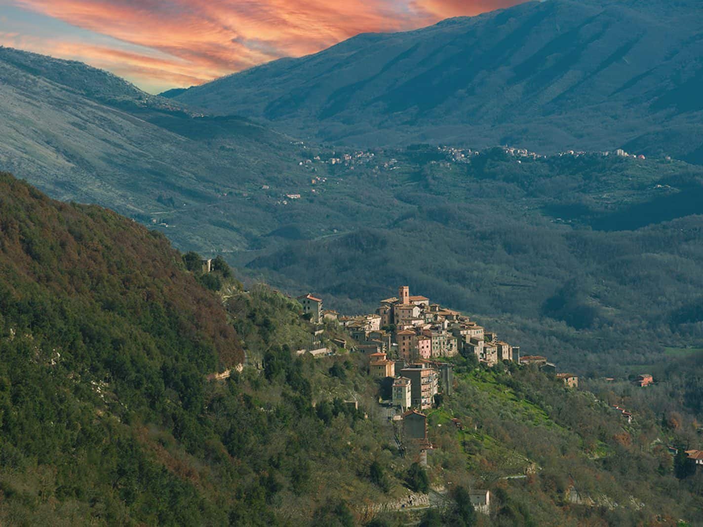

Canterano (RM) is a municipality of just over 350 inhabitants in the upper Aniene valley, in the province of Rome, set at 602 meters above sea level on a slope of the Monti Ruffi, with postal code 00020 and a territory of just 7.3 square kilometers. From Rome it is about 60 kilometers. By car you take the A24 Roma-L'Aquila and exit at Vicovaro-Mandela, then continue on the Tiburtina Valeria toward Subiaco and climb with the provincial road that serves Rocca Canterano and Canterano. The real travel time, Tiburtina traffic included, is a good hour. By public transport the backbone is Cotral, which links Roma Ponte Mammolo (metro line B) to Subiaco, Piazza Falcone. From there the local runs go up toward the villages along the Monti Ruffi slope, and the schedules must be checked on Cotral's official website before setting out, because in municipalities under 1,000 inhabitants the runs are few and concentrated around school hours. Anyone who prefers the train can use the Roma-Avezzano-Pescara line to Mandela-Sambuci station and continue by bus or taxi. The historic center is free to enter, there are no tickets or opening hours: the civic reference point of the upper village is Piazza del Castello, where at number 21 is the seat of the parish of Santa Maria and San Mauro. The town hall is in the same historic core and updated contacts are published on the institutional website of the Municipality of Canterano.
If the trip to Canterano is part of a wider loop outside the Grande Raccordo, it is worth first looking at the overview of the tourist attractions of the Rome area: Canterano works very well as the high stop of an itinerary that touches Subiaco, the monastery of Santa Scolastica and the Aniene valley.
Canterano (RM): where it really is, and why the position matters
Geography here is not a decorative detail: it is the reason the village exists. Canterano occupies a shelf on the eastern flank of the Monti Ruffi, the limestone range that the Lazio Subapennines push between the Monti Prenestini to the west, the Lucretili to the north and the Simbruini to the east. The Aniene valley separates the Ruffi from the Simbruini, and Canterano looks out exactly onto that separation. From the edge of the village the gaze falls on one side onto the gorge where the two Subiaco monasteries stand, San Benedetto and Santa Scolastica, and onto the town of Subiaco that occupies the valley floor. On the other side it opens onto the last spurs of the Monti Prenestini and a succession of green hills that slope down to the course of the Cona, the stream that flows into the Aniene near the Madonna della Pace, the hamlet shared with Agosta.
The administrative boundaries touch Agosta, Gerano, Rocca Canterano, Rocca Santo Stefano and Subiaco, and a few kilometers away is Cervara di Roma, the highest village in the province. Seven square kilometers and 350 residents mean a density of a little under 50 inhabitants per square kilometer: Apennine mountain numbers, not hinterland numbers. The agrarian landscape you cross as you climb says it better than statistics: dense chestnut groves on the cool slopes, terraces grown with vine, olive and hazel where the sun beats down, and dry-stone walls that have held the soil for centuries.
Our opinion: Canterano is not a postcard village and does not try to be. Anyone arriving in search of the scenery of a village restored for tourism will be disappointed. Anyone arriving to understand how people lived on an Apennine slope an hour from Rome finds here one of the most readable laboratories in Lazio.

How to get to Canterano from Rome: the three possible roads
By car to Canterano
The fastest way is the A24 motorway to the Vicovaro-Mandela exit, then State Road 5 Tiburtina Valeria toward Subiaco as far as the junction that climbs toward Rocca Canterano. The climb is a narrow one, with short hairpin turns and low guardrails: no technical difficulty, but in winter ice in the morning hours is a real possibility above 500 meters, and carrying chains between December and March is not excessive caution. Alternatively you can stay on the Tiburtina from the start, leaving Rome by Via Tiburtina and passing through Tivoli, Vicovaro and Agosta: you gain in scenery, you lose at least half an hour.
Parking is the usual problem of Apennine villages built before cars. The wide spots along the provincial road at the entrance to the village are the reasonable choice: you leave the car there and walk up. Driving into the alleys with a small car is possible in theory and inadvisable in practice, because many internal streets are dead ends and the maneuver to get back out, in front of a 16th-century portal, is an exercise I recommend to nobody.
By Cotral bus to Canterano
Extra-urban public transport in Lazio is run by Cotral, which serves the Aniene valley with runs leaving from the Roma Ponte Mammolo terminus, on metro line B, toward Subiaco Piazza Falcone. From Subiaco the local connections leave for the villages along the slope. The operational advice is trivial and decisive: runs to small municipalities are calibrated to the school calendar, so in July, in August and on holidays they thin out quite a lot. Schedules should be checked on the company's official website the day before departure, and it is always worth noting down the time of the last return to Rome before you even get off the bus.
By train plus bus
The Roma-Avezzano-Sulmona-Pescara railway line runs along the lower stretch of the Aniene valley and stops at Mandela-Sambuci, the reference station for the whole area of Vicovaro and Anticoli. From there, getting up to Canterano still takes a connection by road or a taxi. It is the slowest solution of the three, but for those who don't drive it remains workable and has the advantage of crossing by train the most beautiful part of the valley, the one where the Aniene runs sunk between the cliffs.
How long it takes to visit Canterano
The historic center takes an hour and a half walking slowly and stopping to look. If you add the sanctuary of the Madonna degli Angeli, the walk toward the polygonal walls and a panoramic overlook on the Subiaco gorge, the day fills up without effort. The smart way to use Canterano, though, is another: half a day here and half a day in Subiaco, with the two monasteries, or a loop that touches Cervara di Roma and Rocca Canterano. On its own the village is short. Within its valley system it becomes a full day.
The village of Canterano on foot: alleys, steps and squares
Canterano is a vertical village. It has no main axis on which the houses line up, but a structure of overlapping bands that follow the contour lines of the slope: you climb by steps, pass through arches, and come out onto small terraces three meters wide that are in fact the real squares of the village. The upper core still preserves the layout of the medieval castrum, that is of the castle that appears in the documents of the Subiaco abbey, with its covered passages and the retaining walls that confuse the eye: what looks like the base of a house is often the facing of the living rock.
Piazza del Castello, the center of Canterano
Piazza del Castello is the point where the village recognizes itself. Onto it faces the parish church of Santa Maria and San Mauro, which has its civic address at number 21, and here gather the functions that in a municipality of 350 inhabitants hold the community together. The place names say what the documents confirm: the castle was there, and it was not an ornament. The site was chosen for defense, in a line of fortifications that the Abbey of Subiaco arranged to control the valley.
Piazza dell'Olmo
The other gathering place of Canterano is the wide spot that the people of Canterano name after the tree that used to grow there. The elms of Apennine squares have almost all disappeared between the 1970s and the 1990s, decimated by Dutch elm disease, the fungal disease that has wiped the species out of half of Europe. The name of the place has remained, as the name of a thing that no longer exists always remains in the mountains. It is the space where tables are set up during the August festivals and where, on summer evenings, you understand in five minutes how many people really live in the village out of season.
The houses, the portals, the carved dates
Walking slowly you notice the portals with monolithic lintels and, on many of them, the carved date: they are the signs of the 17th- and 18th-century reconstructions, when families that had accumulated a bit of land redid the entrance of the house and put the year on it. It is the most human gesture of peasant building: the date was there to say that the house had been earned. Practical advice: walk with your nose up in the first half of the route and with your eyes down in the second, because the paving of Canterano alternates the ancient flagstones with patches of concrete and your ankles will thank you.
The churches of Canterano: four buildings, four different functions
A village that today counts just over 350 residents, and that before the 20th-century depopulation counted many more, gave itself four places of worship. It is not an excess of devotion: each answered a precise need, and reading them together tells the social organization of the village better than any chronicle.
The church of Santa Maria e San Mauro, parish church of Canterano
It is the mother church, seat of the parish named for Santa Maria and San Mauro, in Piazza del Castello 21, part of the fifth vicariate of the diocese of Tivoli and Palestrina. The double dedication deserves some thought. Mauro is the disciple of Saint Benedict par excellence, the young Roman noble whom Benedictine tradition holds was entrusted to the master in the very years at Subiaco. Naming after him the parish of a castle that belonged to the Abbey of Subiaco is not a neutral choice, it is a declaration of belonging. Every time the name of the patron was pronounced in Canterano, people were reminded who ruled the territory.
Mass times are not fixed as in a city parish, because the parish administrator follows several communities of the valley. Anyone wanting to find the church open should refer to the notices posted on the door or to the contacts of the diocese of Tivoli and Palestrina. In villages of this size there is only one golden rule: churches open for mass and for feast days, the rest of the time you have to ask around, and around you almost always find someone who has the key.
The church of San Rocco in Canterano
San Rocco is the saint of epidemics, the pilgrim from Montpellier invoked against the plague, and his presence in the villages of the central Apennines almost always marks a memory of contagion. The churches and shrines dedicated to him in the Aniene valley multiply between the 16th and 17th centuries, the same decades in which epidemics traveled up the roads from Rome toward the interior. The typical location is at the edge of the settlement, on the access road: the protector saint had to stop the evil before it entered among the houses. Anyone who visits Canterano and finds the church of San Rocco closed should not be surprised: these are buildings that live for the feast day, August 16, and for little else.
The church of Sant'Antonio
The third place of worship in Canterano is dedicated to Sant'Antonio. In the agro-pastoral communities of the Lazio interior the devotion to Anthony, in particular to Anthony the Abbot, is tied to livestock and fire: on January 17 animals were blessed and bonfires were lit. It is the memory of an economy that held at Canterano until the 1950s and that the landscape, with its terraces and its chestnut orchards, continues to tell.
The sanctuary of the Madonna degli Angeli in the locality of Maonna
The fourth place is the most important for the identity of the village, and it is not in the village. The sanctuary of the Madonna degli Angeli stands in the locality of Maonna, a small rural church at a considerable distance from the settlement: that very distance is the reason for the festival we will see further on, because it is the space the statue covers on shoulders, going and returning, over the two days of August 1 and 2. A country sanctuary far from the center is almost always the sign of a cult tied to the land and the harvests, born where people worked and not where they lived. The place name Maonna is the local dialect form of the name Madonna, a case of devotional toponymy that recurs often in the villages of the valley.

The polygonal walls of Canterano and the Pelasgian question
On Via Empolitana II, near the cemetery, remains of polygonal walls emerge: large rough-cut limestone blocks fitted together dry, without mortar, with the irregular joints that give the technique its name. Part of the wall was torn down in 1880 to build the road that now runs alongside it, and that says a lot about how minor archaeology was treated in post-unification Italy. Other stretches are found in the locality of Croce.
What polygonal walls really are
The polygonal technique, long called cyclopean for the size of the blocks, is widespread throughout inland Lazio and Ciociaria: Alatri, Ferentino, Segni and Norba preserve the monumental examples. The chronology is debated and should be taken with a grain of salt: modern archaeology tends to place the greater part of these works between the 4th and 2nd century BC, that is in the Roman or immediately pre-Roman age, scaling back the very high datings of 19th-century scholarship. They served to terrace slopes, to support sanctuaries, to defend hilltop settlements. At Canterano the preserved stretch is modest in extent, but its position, on a ridge road linking the Aniene valley to the passes toward the interior, is consistent with a function of controlling passage.
The Pelasgians: what the learned tradition says and what caution says
In 1911 Lanciotti, in the book I padri della civiltà occidentale printed in Subiaco, proposed a Pelasgian origin for Canterano, explaining the name of the village through the pairing of kan, progenitor of the Pelasgian lineage, and terapne, which in his reconstruction would indicate the dwelling: abode of Kan. The same learned tradition has the Pelasgians as nomads coming from Mesopotamia, arriving on the Lazio coasts through Syria and then moving up to the heights of the Aniene valley, bringing with them the technique of polygonal walls.
It must be said clearly, because the reader has a right to know what degree of certainty they hold in their hands: this is a learned reconstruction of the early 20th century, not an archaeological fact. The very name Pelasgians, in ancient Greek sources, generically indicated pre-Hellenic peoples about whom the Greeks themselves had confused information, and contemporary historiography no longer uses it as a label for an identifiable migrating people. Lanciotti's reconstruction retains an enormous cultural value for Canterano, because it has shaped the idea the village has of itself, but it should not be passed off as established fact. The polygonal wall, that one, remains and can be touched.
The Aequi, the real masters of these mountains
On much firmer ground is whoever speaks of the Aequi, the Italic people who occupied the territory between the Fucino basin and the upper Aniene valley, and who therefore also controlled the site of Canterano. Silius Italicus describes them as people who lived on herding, farming and hunting, rough, strong, proud, terrible to their enemies, always armed even while tilling the fields. The portrait is that of a Latin poet of the Flavian age writing about an enemy long since defeated, so it should be read for what it is: literature, not ethnography. The fact remains that Rome took more than 150 years to bend them.
The stages are known: the victory of 458 BC linked to the name of Cincinnatus, the one of 389 attributed to Camillus, the definitive submission of 304 by Publius Sempronius Sophus. Livy, in the ninth book, recounts that in that campaign 41 castles of the Aequi were burned and that the name of that people was almost entirely erased, with their lands passing to the victors. Counting 41 castles in a territory as big as this means a settlement spread everywhere on the heights: Canterano, with its defensible shelf and its polygonal wall, belongs to that world.
The caves of Bucia Cucera, the underground of Canterano
Not far from the polygonal walls opens one of the most interesting places in the territory of Canterano: a system of very deep underground cavities, which in all probability sheltered humans across the millennia. The route to reach them is wooded and is marked by a series of dry-stone walls, whose structure recalls that of the polygonal walls and which present a frontal semicircle also made of stones. Those walls were examined by the superintendency for cultural heritage and traced back to an ancient burial place.
The water that is no more
In remote times a watercourse ran along this district, and its bed carved in the rock can still be recognized today. Some springs survive and feed small waterfalls and rapids, enough to show what force the original stream had. The local people call the district Acqua Via, a place name that is already a hydraulic description. It is the kind of detail that distinguishes a landscape read from a landscape looked at: the limestone of the Monti Ruffi is a sponge, water disappears into the depths and reappears where the stratification forces it, and the settlement history of all these villages is the history of where the water resurfaced.
Bucia Cucera and the Second World War
The name by which the locality is remembered, Bucia Cucera, is tied to the use the inhabitants of Canterano made of it during the Second World War: in those caves they found shelter from the bombings. It is the most recent and most concrete chapter of the underground of Canterano, and one of the few that the oldest people in the village have still heard told in person. The Aniene valley, crossed by the route to Abruzzo, was a corridor of passage in the final phase of the conflict, and every village on this slope has its cave, its quarry, its stretch of tunnel where the population hid.
A phenomenon of the whole valley
Similar finds have also been made in the neighboring villages, from Rocca Canterano to Rocca di Mezzo, from Ciciliano to Cervara, from Roiate to Bellegra. Lined up, these discoveries make up the most solid proof of very ancient human presence along the whole Monti Ruffi slope. Anyone who wants to go see the caves should keep two things in mind: the path is wooded and not equipped, so you need real boots and not sneakers, and entering deep cavities without equipment and without someone who knows the route is an imprudence to avoid. The dry-stone wall along the route, that one, can be visited safely and is already worth the walk.
Archaeology of Canterano: the axes that are now in Rome
Human presence at Canterano goes back to very remote times, and the proof is not a hypothesis but a set of objects that can be seen in the museums of the capital. It is one of the reasons this village deserves more attention than it receives: its finds are displayed in Rome, while the place of discovery remains almost unknown.
The seven bronze axes
In 1884, in a natural hiding place, seven bronze axes with raised edges were found, made by casting, with a narrowed straight base and the cutting edge widened in a crescent. The location of the find is given by local sources as La Sportelletta. A parallel tradition places the hoard in the cave called moraitana, on Monte Rufo. The two indications may refer to the same site under different names, as often happens in Apennine micro-toponymy, and anyone seeking certainty will have to turn to the superintendency's documentation.
The type of axe with raised edges belongs to the full Bronze Age and is one of the guide artifacts for the chronology of that period in central Italy. The fact that there are seven and that they were deposited together is the interesting part: a hoard is not an accidental loss, it is an intentional deposit. Archaeologists' hypotheses oscillate between the small treasure of an itinerant founder, who set metal aside to be remelted, and the votive offering. The axes are now kept in the collections of the Museo Nazionale Romano, the institution that also includes Palazzo Massimo alle Terme, at Largo di Villa Peretti 2, a short walk from Piazza della Repubblica and Termini station.
The two Neolithic axes in green stone
Older still is the other find from Canterano: two polished axes of the Neolithic age. The first came from the locality Capo la Valle and is in dark green chloromelanite. The second, found in the district Cotoccia, has been referred to gabbro or a similar rock and has a not very dark green ground on which light yellow spots and dark spots stand out. The photographs of the find were published in 1897 by Gioacchino De Angelis d'Ossat, a geologist to whom the village has dedicated a street.
The lithological detail is not a specialist's affectation: the polished green stones of the European Neolithic traveled for hundreds of kilometers along exchange networks that predate any Roman road by millennia. Finding two on a slope of the Monti Ruffi means this territory was already inside a circulation of goods and people. The two axes are kept in the prehistoric and ethnographic collections formerly named for Luigi Pigorini, now part of the Museum of Civilizations in Piazza Guglielmo Marconi 14, in EUR, the institution born in 2016 from the union of four national collections. The prehistoric section is the one that enthusiasts still call the Museo Pigorini.
The two Roman inscriptions in the town hall
From the Roman age Canterano preserves two inscriptions, both recorded in the Corpus Inscriptionum Latinarum. The first was found by Messrs. Filippo and Rocco De Angelis in the enclosure of the ancient castle. The second was identified by Bruzza in the garden near the staircase of the archpriest's dwelling. Today they are kept inside the town hall of Canterano. Two inscriptions are little compared to the hundreds of Tivoli, but they are enough to show that the shelf was occupied in the imperial age and that someone here had the means to have a stone carved.

The name of Canterano: three explanations and no certainty
The origin of the place name Canterano is uncertain, and the three explanations in circulation should be kept clearly distinct by their degree of reliability.
The founder hypothesis
The first is the most narrative: the name would derive from a founder, a Giovanni di Camorrano who, having lost a skirmish against Gerano, made a gift of it to the bishop of Tivoli. It is a tradition of local circles, of the kind that explains the name of a place with the name of a person. Modern etymology considers it an inversion, because almost always it is the surname that derives from the place name and not the other way around.
The hypothesis of the cantors' estate
The second is the most solid on the linguistic level. Canterano would derive from the Latin Cantorianum, that is the estate of the gens Cantoria: predial place names in -anum formed on the owner's name are one of the most widespread types across central Italy, and the form fits perfectly. The interpretive variant that circulates in the village links the name to church cantors, highly esteemed chapter dignitaries who taught adults and young people to read and sing, and who would have been assigned this estate. The two readings do not entirely exclude each other, but the predial mechanism remains the most economical.
The Pelasgian hypothesis
The third is Lanciotti's, from 1911: kan plus terapne, abode of Kan. It has the appeal of 19th-century etymologies and the same fragility. I report it because it fully belongs to the culture of the village and because without it the municipal coat of arms could not be understood, but whoever wants to bet points on the Cantorianum.
The coat of arms of Canterano: a Phoenician ship on the mountain
Here is the most curious object in the village, and it is found on a piece of paper. The municipal coat of arms of Canterano, recognized by decree of the head of government on December 19, 1941, depicts a Phoenician ship on the sea, to attest the ancient origins attributed to the municipality. The banner is a cloth divided into red and blue.
A ship, at 600 meters of elevation, in a village about 70 kilometers from the sea as the crow flies and that never had a port, a navigable river or a shipyard. The coat of arms is the heraldic translation of the learned hypothesis on the eastern origins of the settlement: the vessel that would have brought to Italy the navigators who came from the Levant. The 1941 decree is the date on which that theory became official, blazoned, engraved on the letterhead of the town hall.
I find it one of the most beautiful things that minor Italian heraldry has produced, and for a reason that goes beyond folklore: the coat of arms shows that a village of a few hundred people took its own history so seriously as to put its boldest hypothesis in its own symbol. Go look for it on the facade of the town hall and on municipal documents. Then look around you, from the terraces of Canterano, and try to imagine a sail where the chestnut groves are. It is the best exercise in local history this village can offer.
Canterano and the Abbey of Subiaco: eight centuries of masters
From the Roman age to the 10th century there is no certain news about Canterano, which is the norm for small centers of inland Lazio in those centuries. The village re-emerges in the Subiaco documentation, and from then on its history is the history of whoever owned it.
From mount to estate to castle
The name, in the forms Cantorano, Cantorunu, Cantoranum, appears on a plaque set into the cloister of the Subiaco monastery of Santa Scolastica: first as a mount, then as fundum, finally as castellum. That progression of three words is a novel in miniature. The mount is a rise on which animals are grazed. The estate is a delimited agricultural property. The castle is a fortified settlement with a community inside. Within a few generations, between the 10th and 11th centuries, the mountain becomes a village: it is the incastellamento, the phenomenon that in Lazio created nearly all of the villages we see perched today.
Canterano was one of the castles of the Abbey of Subiaco, placed in a defensive position to guard the valley. Between the 11th and 12th centuries the abbey reached its greatest splendor and controlled a vast territory, which included all the centers of the Aniene valley and extended beyond. The monastery of Santa Scolastica, founded around 520 by Benedict of Nursia, is the oldest Benedictine monastery in the world still active, and its bell tower was erected in 1052: when the people of Canterano saw it from the top of their shelf, they were looking at the center of the power that governed them.
The abbots who behaved like tyrants
Abbatial power degenerated. The elected abbots began to administer the castles as feudal lords, so much so that in 1455 Pope Callixtus III instituted for Subiaco the figure of the commendatory abbot: an abbot external to the monastery, almost always a cardinal, appointed from outside to break the internal dynamics. The cure was worse than the disease, because the commenda turned the abbey into an income to be assigned to the popes' nephews.
Rodrigo Borgia and the Rocca of Canterano
Among the commendatories of Subiaco there is the name that Canterano still remembers: Rodrigo Borgia, the Valencian cardinal who in 1492 would ascend to the papal throne as Alexander VI. Local memory attributes to him a particular fondness for the Rocca of Canterano, where he supposedly retreated for his debaucheries. It should be taken for what it is, a tradition, and it must be said that the black reputation of the Borgias has attracted to itself anecdotes from half of Italy. What remains is the institutional fact, that one solid: the Subiaco commenda was one of the largest incomes of papal Lazio and passed through very powerful hands. A Spanish cardinal who picks a castle of 300 souls on the Monti Ruffi as a secluded place: as an image it works very well, and in Canterano nobody has an interest in denying it.
The long dispute with the bishop of Tivoli
The jurisdiction of the Subiaco abbey was continually contested by the bishop of Tivoli, who claimed the spiritual ministry over the villages of the valley. The agreement came in 1564, when the spiritual ministry of the Tivoli bishop Andrea Croce over Canterano and other villages was established. It was not the end of the game: under Pope Urban VIII, on November 15, 1638, the village returned definitively to the abbots of Subiaco, who governed it until 1753, when it passed to the Congregazione del Buon Governo, the papal body that approved or rejected the requests put forward by the governor of the abbey.
Anyone who knows the administrative history of the Papal States recognizes in this sequence the passage from monastic feudalism to 18th-century centralized bureaucracy. For the people of Canterano little changed in substance and a lot in practice: petitions no longer went to the abbot but to a Roman congregation.
Blessed Amato, the man of Canterano of Santa Maria di Morabotte
In religious history the village was made illustrious by Blessed Amato, son of a certain Tagliavia of Canterano and disciple of Blessed Lorenzo Coricato. Amato was the rebuilder of the cenobium of Santa Maria di Morabotte, one of the 12 monasteries built by Saint Benedict and later destroyed by the Lombards, which had remained a desolate place for about 628 years. He was its first prior and served there for 33 years, in a life of austere and continuous penance. That so small a village gave the Benedictine order the restorer of a cenobium of the first foundation is a title of merit that Canterano still claims.
Poverty, tax collectors and the Unification of Italy
Some documents of the period show a community in conditions of extreme poverty, and over time things got worse, to the point that it was not easy to find anyone willing to take on the post of tax collector for the village. It is a detail worth more than many descriptions: when nobody wants to be the tax collector, it means there is nothing to collect. After 1870 Canterano became one of the many municipalities of the Kingdom of Italy and took part in the life of the nation, with the same dynamics as all the Lazio mountains: emigration, wars, depopulation. The residents recorded by ISTAT at the end of 2024 are 355, on a territory of seven square kilometers: the tally of a century of Italian mountain life is all here.
Festivals and traditions of Canterano: August is the real month
The religious and civic events of Canterano are spread across the year, but it is in August that the village fills up and shows its nature. Dates and programs change from year to year and should be checked on the notices of the Municipality of Canterano and of the parish before setting out.
The festival of the Madonna degli Angeli, August 1 and 2
It is the festival that defines Canterano. On August 1 and 2 the village celebrates the Madonna degli Angeli with a popular participation that has nothing touristy about it. Both on the evening of the 1st and on the following day the heavy statue is carried on shoulders in procession from the village to the rural chapel in the locality of Maonna, very far from the settlement. On both days the trip there and back is made, and doing it takes strong bearers who share the weight and take turns.
Among the popular festivals of the Aniene valley it is perhaps the one that has preserved, more than any other, the rituals of peasant civilization during the course of the procession. On the evening of August 1, on arrival at the small sanctuary, where a stop is made before resuming the return walk, a big fire is lit in honor of the Madonna. The whole route is lit by flares, fireworks, torches and festive lights, which give the religious event a solemnity that is hard to describe to anyone who hasn't seen it.
The advice: if you have only one chance to come to Canterano, make it coincide with the evening of August 1 and bring a flashlight. The procession takes place on road and on trail, the return happens in the dark, and phones are not enough. Stay at the back of the procession, not at the front: from there you see the line of lights climbing, and that is the image you will take home.
The fire, the flares and the stop at the sanctuary
It is worth explaining why a bonfire lit in front of a Marian sanctuary is not a scenic detail. In Apennine festivals the fire marks the point of arrival, purifies the space and closes the daytime part of the rite before the night return. That it has been preserved at Canterano while in half the valley it has disappeared says how much the community cares about the traditional form of its festival. The festive lights and fireworks are the 19th- and 20th-century addition, the bonfire is the ancient core.
The truffle food festival and the chestnut food festival
In autumn Canterano organizes the food festivals tied to the two products of its woods: the truffle and the chestnut, with the truffle festival usually placed in October. These are festivals little promoted outside the valley, and this is at once their limit and their luck: those who get there find village long tables and not a commercial fair. Next to the stalls there is folk music and people dance the ballo della pupazza, the tradition with the puppet that in the Aniene valley accompanies village festivals.
The food walk through alleys and small stairs
The festival of the Madonna is accompanied by a food walk that crosses the alleys and small stairs of the village, with tastings of traditional dishes served in homes and in the wide spots. It is the formula that many villages have copied in the last 20 years, but here it works for a structural reason: the urban fabric of Canterano is made of narrow passages and small stops, that is it is already the perfect setting for a route in stages. Walking among those walls while the village cooks is the most direct way to understand how people lived here.
Why these festivals matter more than they seem
Anyone who looks down on village food festivals has not understood what they are for. In communities of a few hundred people the festival is the only moment in which valley residents, summer vacationers and visitors share the same space and the same table: it is there that customs pass from generation to generation, that the youngest learn the songs and the gestures, that a dialogue worn down by depopulation and by life in front of screens is mended. Maintaining the popular and religious tradition is a cultural and also an economic resource, because it is the only lever with which a municipality of this size can make itself known to provincial and regional tourism without denaturing itself.

The nature around Canterano: Monti Ruffi, chestnut groves and water
The Monti Ruffi, the mountain of Canterano
The Monti Ruffi are a limestone range of the Lazio Subapennines that stretches from northwest to southeast between the Fiumicino valley, which separates them from the Prenestini, and the Aniene valley, which divides them from the Simbruini. To the north they border the Monti Lucretili, to the southeast the Affilani. The highest peak is Monte Costasole, 1253 meters, followed by Monte Macchia with 1135 meters and Forca Travella with 1085. The municipalities that face onto them are Saracinesco, Anticoli Corrado, Marano Equo, Cerreto Laziale, Canterano, Rocca Canterano, Gerano, Rocca Santo Stefano, Bellegra, Roiate and Serrone.
These are mid-altitude mountains, without the spectacular peaks of the Simbruini, and for exactly this reason little visited. Those who walk here find what has been lost elsewhere: ridge trails with nobody on them, beech and Turkey oak woods, sinkholes, swallow holes and limestone outcrops that tell the karst story of the whole area. It is territory for a hiking map and not for improvisation, because the signage is discontinuous and the old pastoral tracks get lost in the woods.
Chestnut groves, olive trees, vines and hazelnuts
The territory of Canterano is covered with woods rich in chestnut and with large terraces grown with vine, olive and hazel. The chestnut orchard is the element that most deserves attention: it is not spontaneous woodland, it is a tree crop planted by humans and maintained for centuries with pruning, clearing and grafting. An abandoned chestnut orchard can be recognized at a glance, because the undergrowth closes in and the low branches dry out. Anyone who climbs to Canterano in October crosses a landscape that is at once natural and artificial, and that was for generations the village's real pantry: the chestnut was bread, flour and money.
The Cona, the Aniene and the water system
Below the village, at the bottom of the green valley that descends toward the west, runs the small river Cona, a tributary of the Aniene into which it flows near the Madonna della Pace, a hamlet of the municipality of Agosta. The Aniene, with its 98.5 kilometers, rises between Filettino and Trevi nel Lazio, collects the waters of the Simbrivio and descends along the valley until it joins the Tiber in Rome, in the Prati Fiscali area near Ponte Salario. It is the river that has given Rome drinking water since the 2nd century BC, and that still feeds it today with the springs of the Acqua Marcia tapped between Arsoli and Agosta, a few kilometers from Canterano.
It is worth pausing on this point, because it is the strongest link between this mountain and the capital. When you open a tap in Rome, the water that comes out is in large part from here. The Aniene valley is not a scenic backdrop: it is a water infrastructure active for 22 centuries.
The Monti Simbruini Regional Natural Park, across from Canterano
From the terrace of Canterano you look straight into the Monti Simbruini, the largest regional natural park in Lazio at 30,000 hectares, spread over seven municipalities between the provinces of Rome and Frosinone: Cervara di Roma, Camerata Nuova, Subiaco, Jenne, Vallepietra, Trevi nel Lazio and Filettino. The highest peak is Monte Viglio at 2156 meters, and several other peaks exceed 2100.
The park preserves some of the largest beech woods in Europe and more than 1,000 recorded plant species, with downy oak, hornbeam, hazel, chestnut, sycamore maple and yew. In the undergrowth are edible mushrooms and wild fruits. The fauna includes the Apennine wolf, the roe deer, the wild boar, the fox, the sporadic presence of the Marsican brown bear and red deer reintroduced between 2008 and 2009. Among the birds of prey are the golden eagle, the goshawk and the peregrine falcon, which is the symbol of the park. In the waters of the Aniene are the brown trout and the freshwater crayfish. The karst plateaus of Camposecco, Campaegli, Fondi di Jenne and Campo della Pietra, some of which reach 500 hectares, are the classic destination for hikes, along with Monte Livata above Subiaco.
One observation: the combination of Canterano and the Simbruini is the best way to use this corner of Lazio in two days. On the first day the village, the polygonal walls, the churches and the valley. On the second the plateau, the beech woods and the monasteries. Anyone who tries to squeeze everything into one day ends up driving more than they walk.
What to see around Canterano within a 20-minute radius
Subiaco and the two Benedictine monasteries
Subiaco, with 8,500 inhabitants on the valley floor, is the largest center of the area and the reason this valley entered European history. Here, in the 6th century, Benedict of Nursia lived as a hermit in a cave above the remains of the villa of the emperor Nero, a complex of buildings arranged on different levels on the right bank of the Aniene, with artificial lakes closed by a dam. The marble bridge that linked the two banks is lost. Of the 13 monasteries Benedict founded, only one survives: Santa Scolastica, the oldest Benedictine monastery still alive, with the Romanesque bell tower of 1052 and the Cosmatesque cloister commissioned by Abbot Lando in the first half of the 13th century.
There is a record that is rarely told at Subiaco and that deserves to be remembered: in 1465 a printing press was installed in the monastery, the first in Italy. The books that came out of that press are the first incunabula printed on the peninsula, and they were composed in a monastery of the Aniene valley, not in a publishing capital. The second monastery, the sanctuary of the Sacro Speco dedicated to San Benedetto, was built in the 12th century over the memory of the saint's cave and leans against the rock face, with fresco cycles that cover the walls entirely. In town you can visit the abbey Rocca, largely transformed between the 16th and 17th centuries, the church of San Francesco of 1327 and the neoclassical church of Sant'Andrea Apostolo.
Cervara di Roma, the highest village
A few kilometers from Canterano you climb to Cervara di Roma, the highest municipality in the province, famous for the artists' staircase and for having been one of the favorite places of the foreign painters who in the 19th century went up the valley in search of models and landscape. The comparison between the two villages is instructive: Cervara chose the path of contemporary art in public space, Canterano left everything as it was. Both choices have a price.
Rocca Canterano, Gerano, Rocca Santo Stefano, Agosta
The neighboring municipalities can each be visited in half a day. Rocca Canterano, the twin village on the same slope, preserves a compact medieval core. Gerano is known for the Infiorata and for the Marian sanctuary. Rocca Santo Stefano looks toward the Affilani. Agosta occupies the valley floor and shares with Canterano the hamlet of Madonna della Pace. These are villages that no general guide mentions and that, lined up, make up one of the best-preserved settlement systems in Lazio.
Tivoli, the gateway to the valley
Going down toward Rome you meet Tivoli, the city that for centuries contested with the Subiaco abbey the jurisdiction over Canterano and that today keeps two sites recognized by UNESCO, Hadrian's Villa and Villa d'Este. Anyone returning from Canterano in the afternoon has time for one of the two, not both: the preference goes to Hadrian's Villa, because you walk through it in a park and not in line.
Palestrina and the other side
On the other side of the Monti Ruffi, beyond the Prenestini, is Palestrina, with the sanctuary of Fortuna Primigenia and the National Archaeological Museum that holds the Nile mosaic. It is another day, but for anyone who wants to understand how this sector of ancient Lazio worked it is the natural complement to the visit to Canterano: the great valley sanctuary and the small hilltop settlements belong to the same system.
Vallepietra and the sanctuary of the Trinità
Higher up, inside the Simbruini park, Vallepietra keeps the sanctuary of the Santissima Trinità, set into the wall of Monte Autore, a destination of pilgrimages that have moved on foot from the Aniene valley and Ciociaria for centuries. Anyone who wants to understand the relationship between these mountains and popular devotion, after seeing the procession of Canterano, finds at Vallepietra the same culture amplified on a regional scale.
Visiting Canterano: practical tips, seasons and accessibility
When to go to Canterano
October is the best month, no argument: the chestnut groves in color, the crisp air that opens the view onto the Subiaco gorge, the truffle and chestnut food festivals. August is the month of the festival and village life, but you have to count on the heat of the valley floor on the way and the busier road. Spring gives the blooming of the ridge meadows and long days for walking. Winter is for those who love empty villages and are not afraid of ice: above 600 meters, between December and February, the road early in the morning can be treacherous.
Canterano with children
The village is all stairs and climbs, so the stroller is unusable: a baby carrier backpack is better. On the other hand the almost total absence of internal traffic makes the historic center a place where children can walk without someone holding their hand every three meters, something impossible in the city. The chestnut grove in autumn, with the harvest, is the activity that works best with the youngest. The caves, instead, are not an activity suitable for children and should be skipped.
Accessibility in Canterano
It must be said frankly: the historic center of Canterano is not accessible to people with mobility difficulties. Small stairs, steep slopes, uneven paving and narrow passages are the norm in a hilltop village that was never redesigned. Those who move in a wheelchair can however enjoy the panoramic overlooks reachable from the provincial road and the wide spots at the village entrance, where the view of the Aniene valley is already the good one. For the parish church and the municipal spaces it is worth asking the Municipality of Canterano in advance which entrances are practicable.
What to eat in Canterano
The local pantry is that of the inland Lazio Apennines: chestnuts in every form, from the roasted fruit to flour, truffle from the woods of the Monti Ruffi, hazelnuts, oil from the low terraces, mushrooms. On festival tables appear the dishes of the valley's peasant tradition, from legume soups to hand-rolled pastas made with the ferretto, to sheep meat. Don't expect a gastronomic scene: in a municipality of 350 inhabitants the places to eat are very few and not necessarily open out of season. The reasonable solution is to eat in Subiaco or Agosta and go up to Canterano for the rest, or to make the visit coincide with a food festival, when the village cooks for everyone.
Where to sleep near Canterano
Lodging in the municipality is very scarce, as is normal in a village of this size. The most sensible logistic base for exploring the Monti Ruffi slope is Subiaco, which has a varied offer and stays within a short distance, or the farm stays scattered along the Aniene valley between Agosta, Marano Equo and Cervara. Anyone who wants to sleep in absolute silence should find a rental house in the village: it is the only arrangement that really works at Canterano, and it is worth organizing in advance.
How much it costs to visit Canterano
Zero. The village has no ticket office, the churches have no admission fee, the trails are free. The only expenses are the trip, lunch and, if you happen to come during a food festival, the tickets for the tastings, which at the village festivals of the valley stay at symbolic amounts. It is one of the few places in Lazio where a whole day out of town costs as much as the fuel.
Photography, silence and good manners
Last recommendation, valid for every village of a few hundred inhabitants: there are no extras here. The people sitting in front of their houses are at home, and a camera pointed at them without a greeting is rude. You say hello, you ask, you almost always get a yes. In return you receive directions, stories and, not rarely, the key to a church.
A curiosity about Canterano (RM)
The most beautiful curiosity of Canterano hangs on the wall of the town hall and nobody notices it: the municipal coat of arms depicts a Phoenician ship on the sea. A village set into the slope of the Monti Ruffi at 602 meters, about 70 kilometers as the crow flies from the Tyrrhenian, with no navigable rivers and not the slightest historical relationship with seafaring, chose a boat as its symbol. The recognition is formal and dated: decree of the head of government of December 19, 1941, with the banner in a cloth divided into red and blue.
The explanation goes back to local scholarship of the early 20th century. In 1911 Lanciotti had maintained for Canterano a Pelasgian origin, linking the place name to kan and terapne, abode of Kan, and leaning on the remains of polygonal walls near Via Empolitana II. That theory has the Pelasgians as navigators arriving from the Levant through Syria and moving up from the Lazio coasts to the heights of the Aniene valley, bringing with them the technique of dry-fitted blocks. The ship on the coat of arms is the vessel that would have taken them to Italy.
30 years later, that reconstruction had become official heraldry. It is the passage that makes the story fascinating: a hypothesis of local history, debatable and today not accepted by research, crossed the bureaucracy of the Kingdom of Italy and ended up blazoned on the letterhead of a municipality. Contemporary historiography considers the term Pelasgians a generic label with which the Greeks indicated poorly known pre-Hellenic peoples, and for the polygonal walls of inland Lazio it tends toward much lower datings, between the 4th and 2nd century BC. But the coat of arms remains, and it is proof that at Canterano history has never been an ornament: it has been a claim.
Without mincing words: anyone who visits Canterano and doesn't ask to see the coat of arms has wasted half the trip. There is not, in all of inland Lazio, a civic symbol that tells better how high a small village can aim.
Something nobody tells you about Canterano (RM)
That the most important finds discovered at Canterano are not at Canterano. They are in Rome, displayed in two large national museums, and almost none of the visitors who look at them know where they come from.
In 1884, in a natural hiding place in the territory of Canterano, indicated by local sources as the locality La Sportelletta and by a parallel tradition as the cave called moraitana on Monte Rufo, seven bronze axes with raised edges were found, made by casting: narrowed straight base, cutting edge widened in a crescent. Seven pieces deposited together are not an accidental loss, they are an intentional hoard, and the discussion among archaeologists oscillates between a founder's metal stock and a votive deposit. Those axes are now in the collections of the Museo Nazionale Romano, the institution of which Palazzo Massimo alle Terme, at Largo di Villa Peretti 2 in Rome, is part.
Even older are two polished Neolithic axes: the first in dark green chloromelanite, from the locality Capo la Valle. The second, from the district Cotoccia, in gabbro or a similar rock, with a green ground mottled with yellow and dark. The photographs of the find were published in 1897 by the geologist Gioacchino De Angelis d'Ossat, for whom the village named a street. The two axes are kept in the prehistoric and ethnographic collections formerly named for Luigi Pigorini, now part of the Museo delle Civiltà, in Piazza Guglielmo Marconi 14 in EUR.
Then there is the Roman tail of the story: two inscriptions recorded in the Corpus Inscriptionum Latinarum, one found by Messrs. Filippo and Rocco De Angelis in the enclosure of the ancient castle, the other identified by Bruzza in the garden near the staircase of the archpriest's dwelling. Those, at least, stayed in the village: they are in the town hall of Canterano. The paradox is all here. A municipality of 350 inhabitants has material displayed in two national museums of the capital, and in the capital nobody connects those pieces with the name of the village. If you go to Palazzo Massimo or to the Museo delle Civiltà after passing through Canterano, the visit changes sign completely.
The advice I give you for visiting Canterano (RM)
Don't come to Canterano on your own and don't come for an hour. The practical advice is to build the day on two poles and in a precise order: the morning down below, the afternoon up high.
Leave Rome early, take the A24 to Vicovaro-Mandela and head to Subiaco. Devote the morning to the two monasteries, Santa Scolastica with the bell tower of 1052 and the Cosmatesque cloister of Abbot Lando, and the Sacro Speco leaning on the rock face. Have lunch on the valley floor, where there are places to eat. Then go up to Canterano in the early afternoon, when the light starts to turn to the west and the village stands out from the slope. Leave the car in the wide spots at the village entrance: you can't maneuver inside the alleys.
The route on foot is simple. You go up to Piazza del Castello, look at the parish church of Santa Maria and San Mauro, continue by the small stairs to the overlooks on the gorge, and return toward Piazza dell'Olmo. Anyone with energy left should go down toward Via Empolitana II to see the remains of the polygonal walls near the cemetery, and anyone with boots and time should continue on the wooded path that leads toward the dry-stone walls in the area of the caves. Do not enter the cavities: they are deep, not equipped, and without someone who knows the route the only thing you gain is a needless risk.
Three recommendations that are worth more than any itinerary. First: check the Cotral bus schedules before leaving, and note down the last return run, because in a village of this size being left on foot in the evening is not a theoretical possibility. Second: if you can choose the date, choose August 1, when the statue of the Madonna degli Angeli leaves on shoulders toward the Maonna, or a weekend in October, when there is the truffle food festival. Third: bring a flashlight and shoes with a treaded sole, always, even in August.
And a piece of advice you won't find elsewhere: talk to people. In a municipality of 350 residents knowledge of the territory is all oral, not published anywhere. The best directions on where the caves open, on where the best stretch of the polygonal wall runs and on how to get to the sanctuary are given by those who live here, and they give them gladly to whoever greets first.

Another well-known fact, yet rarely cited
That Canterano was for eight centuries the property of a monastery everybody in the valley knows, and nobody tells it for what it really means. The name of the village appears on a plaque set into the cloister of the Subiaco monastery of Santa Scolastica in the forms Cantorano, Cantorunu and Cantoranum, and it appears there three times with three different qualifications: first as a mount, then as fundum, finally as castellum. That progression is the history of the Lazio Apennines in three words. The mount is grazing land. The estate is an agricultural property with boundaries. The castle is a fortified settlement with a community inside.
Between the 11th and 12th centuries the Abbey of Subiaco reached its greatest splendor and owned a vast territory, which included all the centers of the Aniene valley and extended well beyond. Canterano was one of the castles placed in a defensive position to control that domain. The practical consequence, for those who lived there, is that the abbot was at once feudal lord, judge and religious authority: a concentration of powers that left no room to maneuver.
The elected abbots soon began to behave like tyrants, to the point that in 1455 Pope Callixtus III introduced the figure of the commendatory abbot, an abbot external to the monastery, most often a cardinal. The reform made things worse, because it turned the abbey into an income to be distributed in great Roman politics. The jurisdiction was long contested by the bishop of Tivoli, and an agreement was reached only in 1564, when the spiritual ministry of the Tivoli bishop Andrea Croce over Canterano and other villages was established. Under Pope Urban VIII, on November 15, 1638, the village returned definitively to the abbots of Subiaco, who governed it until 1753, when it passed to the Congregazione del Buon Governo, the body that approved or rejected the requests put forward by the governor of the abbey.
The little-cited fact, then, is not the dependence on Subiaco: it is that Canterano lived until 1870 within a system in which civil power was a function of monastic power, and that this left traces everywhere, from the dedication of the parish church to San Mauro, disciple of Benedict, to the place names of the castle. A village is not named after the favorite disciple of the order's founder by chance: it does so because it belongs to that order.
The right photo to take at Canterano (RM)
The photograph worth the trip to Canterano is not the alley with the geraniums. It is the long shot from the eastern overlook of the village, with the Subiaco gorge below, the monasteries of San Benedetto and Santa Scolastica clinging to the rock face and the wall of the Monti Simbruini closing the horizon. In a single frame fit the village in the foreground, the Aniene valley in the middle and the regional park in the background: the geography that determined all the history told so far.
The right hour is late afternoon, when the sun turns west and cuts across the slope opposite: the limestone walls above Subiaco take on a warm color and the valley fills with shadow, which increases the separation between planes. Early morning works in the opposite and equally valid way, with haze filling the valley floor and the village emerging above the fog: it is the photograph to take between October and December, when temperature inversions are frequent.
The second framing to count on is vertical and is inside the village: the small stairs of Canterano shot from below, with arches and retaining walls overlapping. You need a moderate wide-angle focal length and you need to accept the dimness, because the covered passages are dark even at noon. The third is the chestnut grove in October, with the light coming down between the old trunks.
If you come on August 1, though, forget everything above. The photograph of the year is the line of lights climbing toward the sanctuary of the Madonna degli Angeli in the dark, with the flares, torches and fireworks along the route and the big bonfire lit on arrival. You shoot from a standstill, with your elbow against a wall, long exposures and high sensitivity. Stay at the tail of the procession: in front you only see the bearers' backs, behind you see the snake of light crossing the mountain. And lower the camera when the statue enters the sanctuary: it is the community's moment, not yours.
Some important events that took place here in history
Great history passed through Canterano several times, almost always sideways, as happens to small places.
The first event is the war between Rome and the Aequi, the Italic people who occupied the territory between the Fucino basin and the upper Aniene valley and who therefore also controlled this shelf. Silius Italicus described them as people who lived on herding, farming and hunting, rough, strong, proud, terrible to their enemies, always armed even while tilling the fields. Rome faced them for generations: the victory of 458 BC linked to the name of Cincinnatus, the one of 389 attributed to Camillus, finally the submission of 304 BC by Publius Sempronius Sophus. Livy, in the ninth book of his work, recounts that in that campaign 41 castles of the Aequi were burned and that the name of that people was almost entirely erased, with their lands passing into the dominion of the victors. A total of 41 hilltop settlements destroyed in a single season of war: the Monti Ruffi slope was full of villages, and Canterano belonged to that world.
The second event is the incastellamento between the 10th and 11th centuries, when the mount becomes an estate and the estate becomes a castle in the Subiaco documentation. It is not a battle, it is a slow transformation, and precisely for this reason it is the fact that determined the form of the village one visits today: the alleys, the small stairs, the retaining walls, the high core tight around Piazza del Castello.
The third is from 1455: Pope Callixtus III institutes the commendatory abbot for Subiaco and the valley enters the game of the great Roman families. From that moment the affairs of Canterano intertwine with the history of pontificates, up to the 1564 agreement with the Tivoli bishop Andrea Croce and the definitive return to the abbots of Subiaco ordered under Urban VIII on November 15, 1638.
The fourth event is archaeological and is from 1884, the year of the discovery of the seven bronze axes in a hoard in the municipal territory. 13 years later, in 1897, Gioacchino De Angelis d'Ossat publishes the photographs of the two Neolithic axes of Capo la Valle and of the district Cotoccia. Between the end of the 19th century and the early 1900s Canterano thus enters Italian scientific literature, and will not leave it again.
The fifth is from 1880 and is a negative fact worth remembering: part of the polygonal walls near Via Empolitana II was torn down to build the road that now runs alongside them. In newly unified Italy minor archaeology was sacrificed to roads without too many scruples, and Canterano paid the price.
The sixth event is the Second World War. The inhabitants of Canterano took refuge in the caves of the locality remembered as Bucia Cucera to shelter from the bombings. It is the most recent and hardest page in the history of the village, and it is the one the oldest people have still heard told in the family. The seventh, finally, is December 19, 1941: in the midst of the war, the decree recognizing the coat of arms with the Phoenician ship. A village that, while the world burned, had its founding legend blazoned.
Who has passed through Canterano (RM)
The list of figures tied to Canterano is short, as is right for a municipality of 350 inhabitants, but the names it contains are of the first rank.
The first is Rodrigo Borgia, the Valencian cardinal who in 1492 became pope with the name Alexander VI. He was commendatory of the Abbey of Subiaco, and local memory attributes to him a fondness for the Rocca of Canterano, where he supposedly retreated for his debaucheries. For fairness it must be said that this is a tradition handed down in the village and not a documented fact: the black reputation of the Borgias has attracted anecdotes throughout Italy. The institutional link between the Borgias and the Subiaco commenda, that one, is history.
The second name is that of Blessed Amato, and he is a real native of Canterano. Son of a Tagliavia of the village and disciple of Blessed Lorenzo Coricato, he was the rebuilder of the cenobium of Santa Maria di Morabotte, one of the 12 monasteries built by Saint Benedict, destroyed by the Lombards and left for about 628 years a desolate place. Amato was its first prior and stayed 33 years in continuous penance of austere life. A man born in a Subiaco castle who puts back on its feet a monastery of the first Benedictine foundation: for the religious history of the valley it is a significant fact.
The third is Andrea Croce, bishop of Tivoli, who in 1564 obtained for the Tivoli diocese the spiritual ministry over Canterano and other villages of the valley, closing a dispute centuries long with the abbots of Subiaco. His name, for the people of Canterano in the 16th century, meant finally knowing whom to turn to.
The fourth is Gioacchino De Angelis d'Ossat, the geologist who in 1897 published the photographs of the Neolithic axes found in the municipal territory, bringing Canterano into the scientific literature of the time. The village dedicated a street to him, which is how small municipalities say thank you.
The fifth is Lanciotti, the author of the book I padri della civiltà occidentale printed in Subiaco in 1911, who proposed the Pelasgian origin of the village and the name kan and terapne. His hypothesis does not hold up under contemporary research, but it entered the municipal coat of arms in 1941 and since then represents Canterano on every official document: few provincial scholars have left such a lasting mark.
Then come the background presences, those that concern the whole valley and that reached Canterano by reflection. The abbots and monks of Santa Scolastica, who exercised jurisdiction here. The painters and Grand Tour travelers who in the 19th century went up the Aniene toward Subiaco, Anticoli and Cervara in search of landscape and models. The pilgrims bound for the sanctuary of the Santissima Trinità of Vallepietra, who set out on foot from the villages of the slope. Canterano was never a destination of that flow, it was a point of passage and observation, which is the role the village continues to play very well.
Quick questions about Canterano (RM)
Where is Canterano (RM)?
Canterano is a municipality of the Metropolitan City of Rome Capital, in the upper Aniene valley, on a slope of the Monti Ruffi, at 602 meters above sea level. It borders Agosta, Gerano, Rocca Canterano, Rocca Santo Stefano and Subiaco. The postal code is 00020.
How far is Canterano from Rome?
About 60 kilometers, which translate into a good hour of travel by car via the A24 and the Vicovaro-Mandela exit. By public transport the time gets longer, because a connection at Subiaco is needed.
How do you get to Canterano by public transport?
With the Cotral buses that leave from the Roma Ponte Mammolo terminus, on metro line B, toward Subiaco Piazza Falcone, and then with the local runs that go up toward the villages along the Monti Ruffi slope. Schedules should be checked on Cotral's official website, because the runs to small municipalities are few and follow the school calendar.
How many inhabitants does Canterano have?
355 residents according to the ISTAT figure as of the end of 2024, on a municipal area of 7.3 square kilometers. The inhabitants are called canteranesi.
Do you pay a ticket to visit Canterano (RM)?
No. The village is free to enter, there is no ticket office or opening hours, and the churches do not charge a ticket. The only expenses are the trip and lunch.
How long does it take to visit Canterano?
An hour and a half for the historic center walking at an easy pace. With the sanctuary of the Madonna degli Angeli, the panoramic overlooks and the walk toward the polygonal walls you comfortably reach half a day. With Subiaco and the monasteries it fills a whole day.
What are the churches of Canterano?
The parish church of Santa Maria e San Mauro in Piazza del Castello 21, the church of San Rocco, the church of Sant'Antonio and the sanctuary of the Madonna degli Angeli in the locality of Maonna, outside the settlement. The parish belongs to the fifth vicariate of the diocese of Tivoli and Palestrina.
Are the churches of Canterano always open?
No, and it is worth knowing before you leave. In municipalities of a few hundred inhabitants places of worship open for services and festivals. The notices posted on the door of the parish church are the most reliable reference, along with the contacts of the diocese of Tivoli and Palestrina.
What is the most important festival of Canterano?
The festival of the Madonna degli Angeli, on August 1 and 2, with the procession that carries the heavy statue on shoulders from the village to the rural chapel in the locality of Maonna, there and back on both days, the big fire lit at the sanctuary on the evening of August 1 and the route lit by flares, torches, fireworks and festive lights.
What is the ballo della pupazza?
It is the popular tradition with the puppet that in the Aniene valley accompanies village festivals, and that at Canterano is performed during the food festivals along with folk music.
When is the truffle food festival held in Canterano?
Usually in October, together with the initiatives tied to the chestnut. The exact dates change from year to year and should be checked on the notices of the Municipality of Canterano before setting out.
What are the polygonal walls of Canterano?
They are remains of walls in large rough-cut limestone blocks fitted together dry, visible near Via Empolitana II close to the cemetery and in the locality of Croce. Part was torn down in 1880 for the construction of the road that runs alongside them.
Are the polygonal walls really Pelasgian?
The Pelasgian reconstruction goes back to local scholarship of 1911 and has great cultural value for the village, but it is not an established archaeological fact. Contemporary research tends to place a large part of the polygonal works of inland Lazio between the 4th and 2nd century BC.
Can you visit the caves of Bucia Cucera?
The wooded path that leads to them, marked by the dry-stone walls examined by the superintendency and traced back to an ancient burial place, can be walked with suitable boots. Entering the deep cavities without equipment and without someone who knows the route is instead an imprudence to avoid.
Why does the coat of arms of Canterano show a ship?
Because it translates into heraldry the hypothesis of the Pelasgian origins of the village: the Phoenician ship on the sea represents the vessel that would have brought to Italy the navigators who came from the Levant. The coat of arms was recognized by decree of December 19, 1941 and the banner is a cloth divided into red and blue.
Where are the bronze axes found at Canterano?
The seven bronze axes with raised edges, found in 1884, are kept in the collections of the Museo Nazionale Romano, the institution of which Palazzo Massimo alle Terme, at Largo di Villa Peretti 2, is part. The two Neolithic axes of Capo la Valle and of the district Cotoccia are in the prehistoric and ethnographic collections formerly named for Luigi Pigorini, now part of the Museo delle Civiltà, in Piazza Guglielmo Marconi 14.
Is Canterano suitable for children?
Yes, with one precaution: the village is all stairs and climbs, so you need a baby carrier backpack and not a stroller. The almost total absence of internal traffic, however, makes the historic center a safe place to walk, and chestnut picking in autumn is the activity that works best with the youngest.
Is Canterano wheelchair accessible?
The historic center no: small stairs, steep slopes, uneven paving and narrow passages are the norm. The panoramic overlooks and the wide spots at the village entrance remain accessible from the provincial road, where the view of the Aniene valley is already broad. For public buildings it is worth asking the Municipality in advance.
Can you eat well in Canterano?
The cooking is that of the inland Lazio Apennines: chestnuts, truffle, hazelnuts, oil, mushrooms, legume soups, hand-rolled pastas, sheep meat. The places to eat in the municipality, however, are very few and not always open out of season: it is better to eat in Subiaco or Agosta, or to make the visit coincide with a food festival.
Where is it best to sleep to visit Canterano?
Subiaco is the most convenient logistic base for the whole Monti Ruffi slope, with the farm stays of the Aniene valley between Agosta, Marano Equo and Cervara as an alternative. In the village the arrangement that works is a rental house, to be organized in good time.
What is the best time to go to Canterano?
October, for the chestnut groves, the crisp air and the food festivals. August for the festival of the Madonna degli Angeli and village life. Spring for walking. Winter only for those who love empty villages and count on ice on the road in the early morning hours.
What is the difference between Canterano and Rocca Canterano?
They are two distinct, neighboring municipalities, on the same slope of the Monti Ruffi, with two different parishes in the same diocesan vicariate: Santa Maria e San Mauro at Canterano, Santa Maria Assunta at Rocca Canterano. They can be visited on the same day without effort.
Is Canterano inside the Monti Simbruini Park?
No. The regional natural park of the Monti Simbruini includes Cervara di Roma, Camerata Nuova, Subiaco, Jenne, Vallepietra, Trevi nel Lazio and Filettino, for 30,000 hectares in total. Canterano is on the opposite side of the valley, on the Monti Ruffi, and looks at the park from the other bank of the Aniene.
What can you see from Canterano?
On one side the Subiaco gorge with the monasteries of San Benedetto and Santa Scolastica and the town of Subiaco on the valley floor. On the other, the last spurs of the Monti Prenestini and the hills that slope down toward the course of the Cona, a tributary of the Aniene that flows into it near the Madonna della Pace.
Do you need to book to visit Canterano?
No, the village can be visited freely. It is worth booking lunch, though, if you plan to eat in the area on a festival day, and organizing lodging in good time on autumn weekends, when the food festivals fill the valley.
Frequently asked questions about Canterano (RM)
Where is Canterano?
Canterano is in the Metropolitan City of Rome Capital, in the upper Aniene valley, on a slope of the Monti Ruffi, at 602 meters above sea level. It borders Agosta, Gerano, Rocca Canterano, Rocca Santo Stefano and Subiaco.
How far is Canterano from Rome?
Canterano is about 60 kilometers from Rome, which translate into a good hour of travel by car taking the A24 motorway to the Vicovaro-Mandela exit and then the Tiburtina Valeria state road toward Subiaco.
What is there to see in Canterano?
In Canterano you can visit the medieval core of the castrum with alleys and small stairs, four churches of different eras, the remains of polygonal walls along Via Empolitana II and the caves of Bucia Cucera, a system of underground cavities that in all probability sheltered humans over the millennia.
When is it best to visit Canterano?
October is the best month to visit Canterano, no argument: the chestnut groves in color, the crisp air that opens the view onto the Subiaco gorge and the truffle and chestnut food festivals. August is the month of the patron saint's festival but brings more heat and traffic.
Why does the coat of arms of Canterano show a ship?
The municipal coat of arms of Canterano, recognized by decree of December 19, 1941, depicts a Phoenician ship on the sea as testimony of ancient origins attributed to the municipality, a curious symbol for a village at 600 meters of elevation and about 70 kilometers as the crow flies from the Tyrrhenian.
Why aren't the archaeological finds discovered at Canterano found at Canterano?
The most important finds discovered in the territory of Canterano, such as the seven bronze axes found in 1884 in a natural hiding place, are now displayed in two large national museums in Rome, while the place of discovery remains almost unknown to visitors.
What is there to see near Canterano?
A few minutes from Canterano is Subiaco, with the two Benedictine monasteries of Santa Scolastica and the Sacro Speco, where in the 6th century Benedict of Nursia lived as a hermit in a cave above the remains of a villa of the emperor Nero.
How long did Canterano belong to the Abbey of Subiaco?
The name of Canterano appears on a plaque set into the cloister of the Subiaco monastery of Santa Scolastica, and for eight centuries the village was property of the abbey, first as a mount, then as an agricultural estate and finally as a castle proper.
Why come back to Canterano (RM)
We close with our opinion on this valley. Canterano does not compete with Subiaco and should not try: the monastery of Santa Scolastica, the Sacro Speco and the abbey Rocca are a heritage of European importance, and anyone with only one day goes there. But anyone who returns a second time to the Aniene valley and limits themselves to the monasteries commits the classic error of fast tourism, that of mistaking the monument for the territory. The monument is understood only from above, from the castles that surrounded it and nourished it for eight centuries. Canterano is one of them, and the most readable.
A concrete and final piece of advice: put August 1 in your calendar. Go up in the late afternoon, leave the car at the village entrance, have someone show you the route to the Maonna and follow the procession to the fire. It is not a show organized for visitors, it is a community carrying a heavy statue on its shoulders for kilometers, as it has done for generations. Being inside it with respect, you learn on this mountain more than any information panel teaches. And the next morning, taking it slow, you go see the polygonal wall.
Anyone organizing a group day in the valley and wanting to move with a professional who knows roads, schedules and festivals can turn to colleagues at TourLeaderPro, who handle tour leading also outside Rome, or to their organization of group trips in Italy for tailor-made programs. Anyone bringing foreign guests will find the English versions of the Roman itineraries in the guide to things to see in Rome and on the page dedicated to day trips from Rome.
Article written by the editorial team of TourLeaderPro, contact them for Private/Corporate/V.I.P. Tours and Experiences.
Planning a trip to Rome? The guides in English for visiting the city are on ItalyPlanner.com.