Percile (RM)
In short. Percile is a comune of just over 200 residents in the Metropolitan City of Roma Capitale, at 575 meters above the upper valley of the Licenza stream, inside the Monti Lucretili regional natural park.
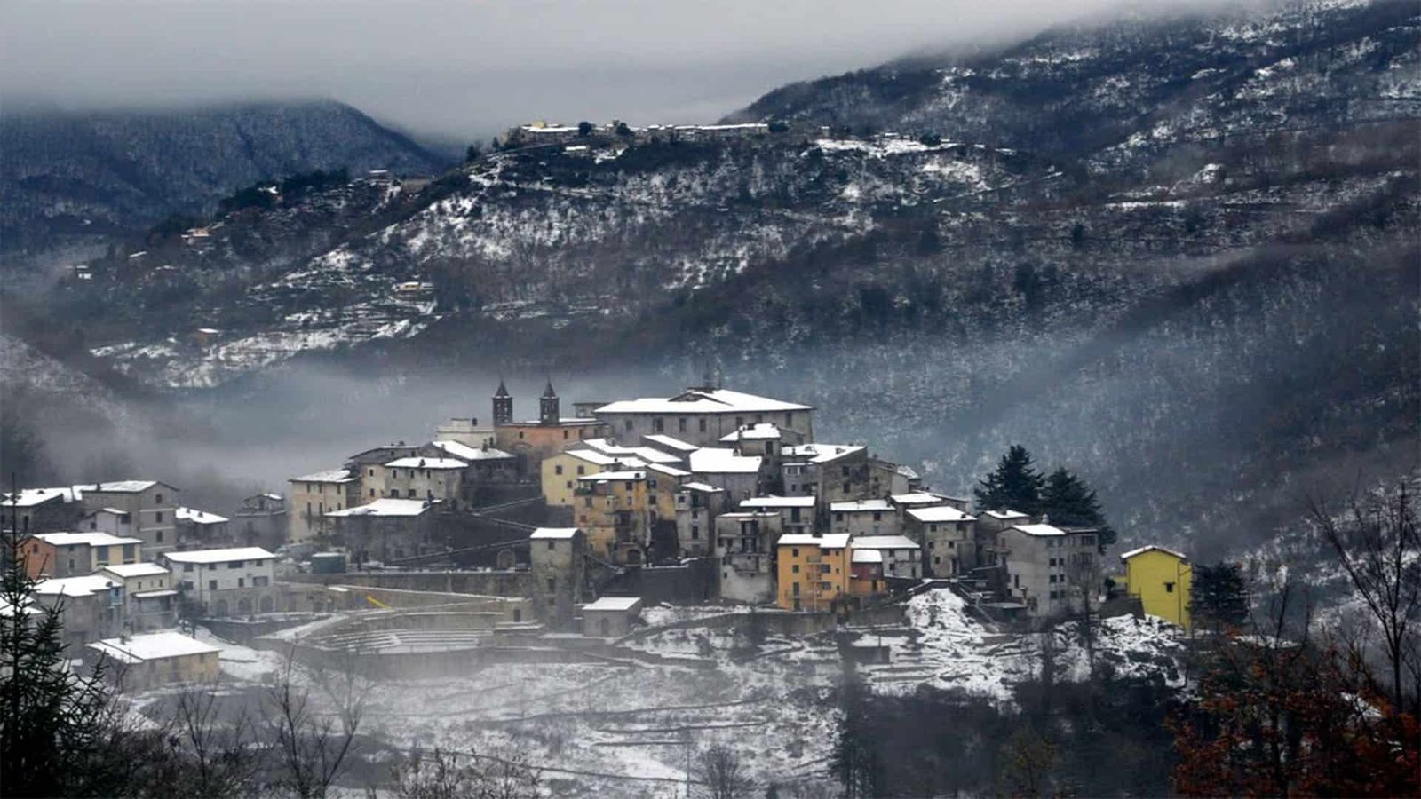
Percile is a comune of just over 200 residents in the Metropolitan City of Roma Capitale, at 575 meters above the upper valley of the Licenza stream, inside the Monti Lucretili regional natural park. From the center of Rome it's about 60 kilometers: A24 toward L'Aquila, Vicovaro-Mandela exit, then the Licinese provincial road toward Licenza and from there the climb up to the village. By train you reach the Mandela-Sambuci station on the Avezzano line and continue by regional intercity bus: runs are few and change with the school calendar, so check the times on the carrier's website before leaving. The village has no ticket office and no turnstiles, you enter on foot and for free. The town hall is at Via Attorno Palazzo Borghese 8, 00020 Percile, phone 0774 469019, and it's the reference for tourist information along with the Monti Lucretili Park portal. Park in the widening at the entrance to the town: inside the walls the streets are only as wide as a cart, and bringing a car in is a terrible idea.

Where Percile (RM) Is and How to Really Get There
Geography explains the town better than any chronicle. Percile sits on a modest rise that closes the Licenza valley to the north, the stream that runs down toward Vicovaro and ends in the Aniene. It's the last settlement before the road turns into a mule track and the forest takes over everything. To the west rises the ridge of the Monti Lucretili Park with Monte Pellecchia, the highest peak of the group. To the east, beyond the watershed, begins the province of Rieti with the basin of Lake Turano.
By Car to Percile
The natural route is the A24 Rome-L'Aquila highway, Vicovaro-Mandela exit, then signs for Licenza. From the Tiburtina Valeria you climb the Licinese provincial road, a narrow, winding road that gains 300 meters of altitude in about 10 kilometers. In winter, after a snowfall, the upper stretch can be icy early in the morning: if you arrive with summer tires, wait for the sun to come around onto the slope. The real travel time from the Grande Raccordo Anulare, without traffic, is more than an hour. On the Sunday of a food festival, count on an hour and a half and plan on parking far away.
By Public Transport to Percile
The regional railway for Avezzano stops at Mandela-Sambuci, which is about 10 kilometers of curves from the village. From there the connection is left to the regional intercity bus lines that serve the Licenza valley. The frequencies are those of a mountain town, that is two or three runs a day, concentrated on school hours and reduced on holidays: the practical advice is to check the updated timetable on the carrier's website and, failing that, to phone the town hall. Anyone who doesn't drive and still wants to see the lagustelli in a day should work out the return before leaving: being stranded in Percile at six in the evening, in November, is a formative but uncomfortable experience.
When to Go to Percile
May and October. The first for the wild asparagus and for the high water in the little lakes, the second for the woods turning copper and for the chestnuts. July and August at altitude are easy to bear, but the vegetation is dusty and the water of the lagustelli drops. December has the food festival and the village dressed up for the holidays, but the days are very short and the path toward the lakes, if it has rained, becomes one continuous slide. The best moment of the year is the second half of October, setting out from the village by nine in the morning.
The Village of Percile (RM), Street by Street
Percile can be visited in under an hour and understood in three. It's a compact core, of gray stone, with alleys that open onto private vegetable plots and gardens and houses leaning against each other to save wall and heat. There are no monuments with lines. There is a medieval urban fabric that has remained almost intact because the town never grew enough to need to demolish it. Since 2018 Percile has been part of the Most Beautiful Villages in Italy circuit, and the entry into the club shows in the care of the paving and the signs.
The Fishpond at the Entrance of Percile
The first thing you meet going up is a large fishpond fed by the waters of the Licenza stream, clear and fast even in midsummer. It's not a recent embellishment: tanks of this type were used to raise freshwater fish for mountain communities and to regulate the irrigation of the vegetable plots downhill. Today it's the place where children stop for a full 10 minutes to look at the bottom, and where it's worth filling your water bottle before starting the climb.
The Fonte degli Aliucci
A little farther on, a very short detour on the left leads toward the cemetery: following its right side you reach the Fonte degli Aliucci. The water is low-mineral, very light, and local tradition has always indicated it as an aid for kidney problems and for diets. Its use goes back to Roman times, which in the Sabina is not a romantic detail: good springs were infrastructure, and roads and properties were built around a spring. Bring an empty bottle. It's not often you drink water that someone drank when emperor was a job.
Piazza, Palazzo Borghese and the Percile Information Point
The Historic Center is overlooked by the baronial palace, which the Park's information sheet dates to the 13th century and which began as a castle, transformed over the centuries into a noble residence and today the seat of the town hall. The name everyone uses for it, Palazzo Borghese, comes from the last feudal family. The square in front was recently repaved and hosts an information point with material on the Park: brochures, trail maps, nature publications. It's worth a stop before setting out, because the paper maps of the Lucretili are still more reliable than the phone signal, which above 700 meters comes and goes.

The Churches of Percile (RM)
Three buildings, three eras, three different social functions. Anyone who arrives expecting to find a single church is left surprised: a town of 200 souls that preserves three tells a story of scattered communities that slowly gathered around their own parish churches.
Santa Lucia Church, the Parish Church
It is the mother church, dedicated to the patron saint, and it stands at the highest point of the town, leaning against the baronial palace. The layout is sixteenth-century, with an older core linked to the Orsini castle. The parish belongs to the fourth vicariate of the Diocese of Tivoli and Palestrina. The detail that makes it recognizable from afar is the two twin bell towers: the seventeenth-century building had only one, replaced by the present pair in 1914. Inside are preserved frescoes ranging from the sixteenth to the eighteenth century. The times of services are not published reliably: for an interior visit it's best to ask at the town hall or the parish priest.
Sant'Anatolia Church
Built in 1642 and restored in 1968, it preserves seventeenth-century frescoes. The dedication is a valuable trace: Anatolia is the Sabine martyr par excellence, venerated along the ridge between Rieti and the Aniene valley, and her presence here signals how much Percile looked culturally north rather than toward Rome. It's the least visited of the three and the one where, if you find it open, it feels best to be: little light, lively plaster, nobody.
Santa Maria della Vittoria Church and the Hermitage
The oldest in the town, Romanesque in layout with reused Roman elements, assigned by current sheets to the 12th century. A tenacious local tradition instead has it built by Charles of Anjou to commemorate the victory over Conradin of Swabia at Tagliacozzo, in 1268: it is an attribution of tradition, not a documented fact, and should be taken as such. Next to it stands a hermitage, which is the reason the church is isolated from the town. The town hall lists it among the places to see. Interior access is not continuous.
The Lagustelli, the Little Lakes of Percile
They are the reason most visitors climb all the way up here, and they deserve a page of their own: you'll find it in the dedicated guide to the Percile Lakes, with the itinerary described step by step. Here it's enough to frame them, because without them the village can't be understood.
Two Sinkholes Filled with Water
The lagustelli are not lakes in the common sense of the term: they are karst depressions, sinkholes born from the collapse of the ground through underground dissolution of limestone and then waterproofed by clay sediments. Neither has surface inflows or outflows. The Marraone receives water from a spring of strongly variable flow that gushes a few meters above the maximum level, on the eastern slope. The Fraturno is fed by underground contributions. This is the reason for their color, which goes from emerald green to murky depending on the season and the rains, and for their fragility.
The Fraturno and the Marraone
The Fraturno is the larger: ellipsoidal in shape, with a maximum diameter of around 118 meters in spring, about 9,000 square meters of surface, a maximum depth of 16 meters, with banks that drop steeply right after the shore. It lies at about 704 meters of altitude and appears suddenly among the trees, which is the effect that leaves first-time arrivals open-mouthed. The Marraone, at 674 meters, is circular, about 40 meters wide, closed in by overhanging walls: it is so recessed that you see it well only from above, and reaching its shore is awkward and not advisable.
Why the Percile Lakes Are a Ramsar Zone
In 2008 the area was recognized as a wetland of international importance under the Ramsar Convention, and the Park's plan classifies it as a strict reserve. It is not a decorative stamp. On the muddy shores grows a rare grass, Heleochloa alopecuroides, together with marsh reed, willows and poplars: a plant community that a swim, a loose dog or a picnic on the shore destroys in one season. You don't go into the water, you don't introduce fish, you don't trample the shores. Whoever tells you the lagustelli are a nice place to swim is giving you advice that costs a fine and a habitat.
CAI Trail 307 from Percile to the Little Lakes
The official itinerary starts from the center of Percile and is classified T, that is tourist: 5.5 kilometers, about 1 hour and 50 minutes of walking, 130 meters of elevation gain and 140 of descent. It follows the Aone valley among the shrubs, climbs a panoramic stretch overlooking the Licenza valley, crosses reforested areas and touches the Porcareccia forest hut. Along the way the layers of the Guadagnolo Formation crop out, calcarenites of different tones that tell of the sea floor from which these mountains are born. A short detour leads to the ruins of the medieval castle of Castel del Lago, at 772 meters. Shoes with a lugged sole, not tennis shoes: the ground is earth and gravel and going downhill it doesn't forgive.

The State-Owned Lago Estate and the Woods Around Percile (RM)
The municipal territory includes the regional state-owned estate called Lago, an oasis of about 900 hectares made of woods, clearings and nature trails. This is where the landscape changes register: you pass from the oaks and manna ash of the lower belt to the bushy pastures of the ridges, with Monte Pellecchia as a backdrop. Among the little lakes grow maples, manna ash and Judas trees, and in autumn the Fraturno finds itself surrounded by oaks, firs and cypresses in a color combination that painters come looking for on purpose.
The Animals of the Monti Lucretili Around Percile
The Park's sheets list pine marten, polecat, weasel and golden eagle. They are all species that indicate a mature, little-disturbed forest. The most striking fact, though, has a date: in the autumn of 1997 a Marsican brown bear found refuge in these woods, returning to a territory that the species had occupied in historical times. It is not material for a planned sighting, to be clear: it is a clue to how permeable to large fauna the ridge between the Lucretili, the Simbruini and the Velino-Sirente still is. If you are looking for a realistic nature thrill, aim for the golden eagle flying along the ridge on windy days.
Other Trails Starting from Percile
From the village several marked trails of the Club Alpino Italiano branch out, and the territory is crossed by the Cammino Naturale dei Parchi. The classic destinations beyond the lagustelli are Monte Pellecchia, the Porcareccia and the loops that descend toward the ditches of the Prata and the Rosciella. Anyone who wants a secondary goal on the same day should look at Monte Lagusiello, which looks out right over the hollow of the lakes.
The History of Percile (RM), from Prehistory to the Borghese
L'Ardino and the Early Bronze Age
The oldest document of Percile is not written: it is an archaeological layer identified in the locality of l'Ardino, referred to an occupation of the Early Bronze Age. For reconstructing the chronological and cultural sequence of the whole Lucretili area it is a first-rate find, because it confirms the presence of human groups along the preferred penetration corridors of the mountain, which in this case is the valley of the Licenza stream. The pottery materials unequivocally document a trans-Apennine cultural influence: the communities living here were in contact with the other side of the range. Translated: 4,000 years ago Percile was a passage, not a dead end.
The Name, the Gens Porcia and the Fundum Percilianum
The most accredited etymology derives the place name from the name of the Roman gens Porcia, that is from a landed property of that family. The first written mention appears in the biography of Saint Sylvester I, pope between 314 and 335, where Anastasius the Librarian cites a fundum Percilianum in territorio Sabinensi. Of the classical age few but telling things remain: a marble stele with the image of a girl of about seven, burial markers, architectural elements reused in the churches. The houses were then grouped into villae and pagus, the scattered settlement typical of the Roman countryside. Only later, with Christianity, did the inhabitants begin to gather around little churches and parish churches.
Farfa, the Orsini, the Borghese
In the 10th century the mountain fills with castles, built to defend the villages of the valley. In 1011 the Count of Sabina Ottone donates 1,500 moggi of arable land, and it is the act that ties Percile to the Abbey of Farfa: the town appears among the Farfa possessions at the beginning of the 11th century and stays there for a couple of centuries. The passage to the Orsini follows, the great baronial family that controlled half of the Sabina and the Aniene valley, and in 1608 the transfer to Giovanni Battista Borghese, Duke of Rignano, whose house would remain feudal lord until the unification of Italy. Each passage has left a walled-in sign: the castle that becomes a palace, the church that leans on the castle, the coat of arms on the portal.
Porcile in the Popes' Maps
In the Gallery of Maps of the Vatican Museums, made between 1580 and 1585 under the direction of the cosmographer Egnazio Danti, in one of the two maps dedicated to Lazio the town appears with the spelling Porcile. It is a cartographic curiosity that is worth a historical confirmation: at the end of the 16th century this handful of houses at the top of the Licenza valley was relevant enough to deserve a name on a wall of the Apostolic Palace.
Garibaldians, Wars, Depopulation
In the 19th century, after the battle of Mentana in 1867, some Garibaldians found refuge in Percile: the memory has remained in the street names. The First World War cost the town 27 dead, an enormous number for a community of that size. In the second the village was hit by bombings that forced the inhabitants to shelter as best they could in caves and huts in the vicinity. Then came depopulation, which in this mountain belt has emptied entire towns. Percile held on under 300 inhabitants and chose the path of environmental quality: the promotion as a village and the entry into the national circuit in 2018 are the result of that choice.

What to Eat in Percile (RM)
Ramiccia
Ramiccia is the signature dish of the village: fresh pasta fettuccine cut very thin by hand by the women of Percile, dressed with a sauce that local tradition ties to mutton. For the festival, about 1,500 eggs are worked into dough by hand, which gives an idea of the scale of the operation in a town of 200 inhabitants. The cutting is the hard part: the sheet of dough has to be reduced to very thin strands without breaking them, and it's a technique you learn by watching, not by reading. If you come through town out of season, you can ask in the trattorias of the Licenza valley: some make it to order.
Sparaci, Chestnuts and Sweets
Sparaci are wild asparagus, the thin, slightly bitter kind that sprout along stone walls and at the edge of the woods in April and May. Chestnuts arrive in autumn and have their own festival at the end of October. On the sweet side, tradition keeps amaretti, anise tisichelle and nociata, the walnut and honey nougat made in Sabina for Christmas. Add honey and sausages and you have the full basket. There are no starred restaurants, there are home kitchens: adjust your expectations and you'll be happy.
Percile's Festival Calendar
The most important is the Sagra della Ramiccia, held on the first Sunday of December and coinciding with the period of the patron saint, Santa Lucia. In May there are the Sagra degli Sparaci and the Festa dei Laghi, which opens the hiking season: it celebrates the mountain in the Lago state forest with walks on foot, on horseback and by mountain bike, and with outdoor kitchens. At the end of October it's the turn of the Sagra della Castagna. In September the town also hosts a long-running theater and music series, promoted by a local association, which uses Piazza Garibaldi as its stage. The exact dates change every year: the reliable way to check them is the Comune di Percile website.
A Curiosity About Percile (RM)
The real curiosity of Percile is not the village: it's the fact that two pools of water as wide as a tennis court have the same international recognition as the Danube Delta. Since 2008 the Lagustelli have been listed among the wetlands protected by the Ramsar Convention, the treaty signed in 1971 in the Iranian city that gives it its name, originally meant to save the routes of migratory waterbirds. The paradox is that there is no lagoon or estuary here: there are two karst sinkholes at an elevation of 700 meters, with no inflows and no outflows, fed by capricious springs and sealed by a plug of clay.
The reason for the recognition is ecological, not scenic. Basins of this kind, isolated and with no surface water exchange, host plant and animal communities that elsewhere have been wiped out by land reclamation and intensive agriculture. On the muddy banks of the Fraturno grows Heleochloa alopecuroides, a rare grass that needs exactly that combination of mud, seasonal swings in water level and absence of trampling. One summer of bathers is enough to sweep it away.
Then there is a second level of curiosity, a geological one. The Fraturno reaches 16 meters in depth over a surface of 9,000 square meters: the proportions of a funnel, not a lake. The banks drop away right after the shore, which is the typical shape of a cavity collapsed from above, not of a basin carved by running water. The Marraone, 40 meters in diameter between overhanging walls, is even more telling. If you arrive at the lakes knowing this, you look at them differently: under those lake beds there is a system of channels in the rock that keeps working, and the water level rising and falling from one season to the next is proof that the mechanism is alive.
One Thing Nobody Tells You About Percile (RM)
That the village once had a bear. In autumn 1997 a Marsican brown bear took refuge in the woods of Percile's territory, and the Park's fact sheets list it as a return to a historic range of the species. It's not barroom anecdote: it's a wildlife fact that tells you how much the forest continuity between the Monti Lucretili, the Simbruini and the Velino-Sirente massif is still enough to let a 150-kilogram plantigrade travel without anyone intercepting it for weeks.
The second thing nobody will tell you is about the water. The Marraone and the Fraturno change level dramatically over the year, because the spring that feeds them has a highly variable flow and there is no regulator. It means the perfect photo you saw online, with the water full up to the trees, was almost always taken between March and May. In August you find the same lakes lower by a couple of meters, with a band of bare mud around them. It's not degradation, it's how they normally work: but if you arrive in August expecting the spring postcard, you go home disappointed for a reason no guide explained to you.
Third thing, the most practical: in Percile the services are those of a town of 200 inhabitants. Don't take for granted that you'll find an open bar on a midweek afternoon in February, or an ATM, or a grocery store with continuous hours. Whoever leads groups in this area brings water, sandwiches and a full tank of fuel filled in the valley. It's a detail that turns a successful outing into a rough day if you discover it on the spot.
Frequently Asked Questions About Percile (RM)
Where exactly is Percile (RM)?
Percile is in the Metropolitan City of Rome Capital, at 575 meters above sea level in the upper valley of the Licenza stream, inside the Monti Lucretili Regional Natural Park. The town hall is at Via Attorno Palazzo Borghese 8, 00020 Percile.
How far is Percile from Rome?
Percile is about 60 kilometers from the center of Rome, a little over an hour by car without traffic. The village occupies a modest rise that closes the Licenza valley to the north, the last settlement before the road turns into a mule track.
What do you eat in Percile?
The signature dish of Percile is ramiccia, fresh pasta fettuccine cut very thin by hand by the women of the village and dressed with a sauce that local tradition ties to mutton. For the Sagra della Ramiccia, on the first Sunday of December, about 1,500 eggs are worked into dough by hand.
Is Percile suitable for kids?
Yes, the village of Percile suits children well because it's small, closed to through traffic, with the fish pond at the entrance working as a magnet. Trail 307 to the little lakes is classified as tourist and a child from age seven up can handle it without problems.
Where to stay near Percile?
Percile has no structured accommodation offering: hospitality is small-scale, among room rentals, vacation homes and agriturismi spread across the Licenza valley and neighboring towns. If you want more choice, look at the area between Vicovaro and Mandela, 20 minutes away by road, or Tivoli.
What are the Lagustelli of Percile?
The Lagustelli of Percile are two water-filled sinkholes, karst depressions born from the collapse of the ground, which since 2008 have been listed among the wetlands protected by the Ramsar Convention, the same international recognition as the Danube Delta. They are just outside the village, inside the Lago state estate.
Is Percile one of the Most Beautiful Villages in Italy?
Yes, since 2018 Percile has been part of the Most Beautiful Villages in Italy circuit, a recognition for the compact core in gray stone that stayed almost intact because the town never grew enough to need to demolish it.
Was there a bear in Percile?
Yes, in autumn 1997 a Marsican brown bear took refuge in the woods of Percile's territory, and the fact sheets of the Monti Lucretili Park list it as a return to a historic range of the species, a sign of the forest continuity of the area.
My Advice for Visiting Percile (RM)
Flip the order everyone follows. The vast majority of visitors arrive, park, take the trail to the lagustelli, come back in the early afternoon, eat and leave without having seen the village. Do the opposite: arrive early, spend the first 40 minutes on the village with the low morning light on the stone, stop by the fish pond and the Fonte degli Aliucci, climb to the twin bell towers of Santa Lucia, pick up maps at the information point. Then set off for the lakes around 10:30, when the sun has already turned over the basin and the water stops being a dark slab.
On the trail, my advice is to take the T classification seriously. Tourist means there are no exposed sections, not that you're walking on a sidewalk: 5.5 kilometers on dirt and gravel, with 130 meters of elevation gain, call for shoes with lugged soles and at least a liter of water each. There are no usable fountains along the route. The detour to the ruins of Castel del Lago, at 772 meters, adds little time and a lot of meaning: from up there you understand at a glance why in the Middle Ages they built in exactly that spot.
One last recommendation. The lagustelli are a strict reserve in the Park's plan: don't go into the water, don't leave trash, keep dogs on a leash and don't trample the muddy banks. The appeal of this place depends on the fact that so far few people have passed through, and with respect. If you want to organize the day without worries, or bring a group here, a guide who knows the valley solves in half an hour the logistics problems that cost an afternoon on your own: TourLeaderPro offers professional tour guiding on exactly this kind of itinerary.
Another Well-Known Fact, Yet Rarely Mentioned
That Percile is written on a wall of the Vatican Museums, and under the wrong name. In the Gallery of Maps, the 120 meters of corridor frescoed between 1580 and 1585 to a design by the Dominican Egnazio Danti for Gregory XIII, one of the two maps devoted to Lazio lists the town as Porcile. It's not a copying error: it's the current form of the place name at that time, the same one found in several documents of the modern era, before administrative usage fixed the present spelling.
The fact is well known in town, cited in almost all local fact sheets, and yet no one draws the interesting consequence. The Gallery of Maps is not a collection of curiosities: it's a political operation, the representation of Italy as an ecclesiastical territory carried out by a pope who claimed jurisdiction. Ending up on those walls meant being part of the Church's patrimony, and in fact Percile was: first belonging to Farfa, then passed through baronial hands that nonetheless owed the fief to the Holy See. The map is both a map and a deed of ownership.
The second well-known and little-exploited fact concerns the etymology. If the name really comes from the gens Porcia, as the most widespread reconstruction holds, the sixteenth-century form Porcile is closer to the original than the current one: not a corruption, but a remnant. The consonant cluster then softened through popular usage, perhaps also to escape the homophony with a word no community likes to have on its road sign. The two spellings coexist on maps for at least two centuries.
The Right Photo to Take in Percile (RM)
The photo that works is not the one of the water, it's the one of the edge. Stand on the high trail that goes down toward the Fraturno, with trees in the foreground on one side of the frame and the water surface taking up the lower third: it's the only point from which you can read the funnel shape of the sinkhole, which is the geological reason for the landscape. Photographed from the shore, the surface becomes a flat green patch and the depth disappears. Photographed from above and at an angle, you see the collapse.
Light: mid-morning in spring, or late afternoon in October. At noon the overhead sun kills the green and fills the water with white reflections. A circular polarizer is really useful here, because it cuts the veil of reflection on the surface and brings out the true color, which on good days is a bottle green with bluish shades. In autumn the crown of oaks, firs and cypresses around the larger lake gives a palette that needs no retouching at all.
In the village the right photo is a different one and is taken early in the morning: the two twin bell towers of Santa Lucia against the sky, shot from below from an alley, with the gray stone catching the low light. It's the image that tells Percile in a single frame, because that pair of towers from 1914 is the only monumental element visible from a distance in a village made of packed-together houses. Third option for those who love details: the fish pond at the entrance, with the water of the Licenza running, a long exposure and the surface turning to silk.

Some Important Events That Happened Here in History
Early Bronze Age. At the locality of l'Ardino lies the archaeological layer that is the oldest document of human occupation in this stretch of the Lucretili. The ceramic materials show a trans-Apennine cultural influence: the Licenza valley worked as a transit corridor between the two sides of the range.
Between 314 and 335. In the biography of Saint Sylvester I, Anastasius the Librarian cites the fundum Percilianum in territorio Sabinensi. It is the first written appearance of the name, and it certifies that at that date a recognizable landed property existed.
1011. Otto, Count of Sabina, donates 1,500 moggi of arable land: the deed ties Percile to the Abbey of Farfa, which keeps control of it for about two centuries. It's the period when the mountain fills with castles and the scattered population gathers together.
1268, by tradition. Local memory attributes to Charles of Anjou the erection of Santa Maria della Vittoria Church as an ex voto for the defeat of Conradin of Swabia at Tagliacozzo. Current datings instead place the building in the 12th century. Tradition remains tradition, but it explains the title of the church.
1580-1585. The town is depicted, spelled Porcile, in one of the two maps of Lazio in the Gallery of Maps in the Vatican.
1608. The fief passes to Giovanni Battista Borghese, Duke of Rignano. The medieval castle definitively becomes a baronial palace, the building that now houses the Town Hall.
1867. After the Battle of Mentana, some Garibaldians find refuge in Percile. The street names preserve the memory of it.
1914. The single bell tower of the seventeenth-century parish church is replaced by the pair of twin towers that still identifies the profile of the village from afar.
1915-1918. World War I costs Percile 27 fallen, a proportionally enormous loss for a community of that size.
World War II. The village is hit by bombing and the population is forced to take shelter in caves and huts in the surrounding area. It is the event that, together with the postwar depopulation of the mountains, marks the demographics of the municipality for the following decades.
Autumn 1997. A Marsican brown bear takes refuge in the woods of the municipal territory, reclaiming a historic range of the species.
2008. The Lagustelli enter the list of wetlands of international importance of the Ramsar Convention, and the Park's plan classifies them as a strict reserve zone.
2018. Percile joins the Most Beautiful Villages in Italy circuit, which becomes the linchpin of the municipal tourism strategy.
Who Passed Through Percile (RM)
Anastasius the Librarian, librarian of the Roman Church in the 9th century, never set foot here but passed through with his pen: it is in the writing of the biography of Saint Sylvester I that the fundum Percilianum appears, and it is to him that Percile owes its documentary birth certificate.
Otto, Count of Sabina. In 1011 he signs the donation of the 1,500 moggi that hands the territory to the Abbey of Farfa. Behind a notarial deed like this there is always a strategy: the Farfa monks were building a compact territorial domain between the Tiber and the Aniene, and the passes of the Licenza valley served to close it.
The Orsini. The baronial family that from the 13th century on controls half of Sabina and the Aniene valley also holds Percile, and the oldest core of the parish church of Santa Lucia remains attached to their castle. The Orsini were not visitors: they were the local power, with everything that implied in terms of levies, justice and building works.
Giovanni Battista Borghese, Duke of Rignano. He acquires the fief in 1608. The Borghese, the family of Pope Paul V, were then building the landholdings that would feed the Roman collections of the Galleria Borghese: Percile is a peripheral tile of that operation, and the palace on the square still bears the name.
Egnazio Danti and the cartographers of Gregory XIII. They did not come up here, but they gathered the data that put the town on the walls of the Gallery of Maps between 1580 and 1585. For a municipality of this size, appearing in that cartographic enterprise amounts to a promotion.
The Garibaldians of Mentana. In November 1867, after the defeat against the papal and French troops, groups of scattered volunteers went up the Apennine valleys looking for refuge. Some reached Percile, and the street names remember it.
Painters and walkers. From the 19th century on, the basin of the lagustelli attracts landscape painters and, later, hikers: the color of the water and the crown of trees have a painterly quality that explains how often the subject recurs. Today the baton has passed to trekking enthusiasts, who climb from the village along trail 307.
The bear. In autumn 1997, for a few weeks, the most illustrious visitor of the Percile woods had fur. I mean it seriously: the presence of a Marsican on this ridge is worth, as an environmental indicator, as much as a protection decree.
Percile (RM) with Kids, Family and Accessibility
The village suits children well: it's small, closed to through traffic, with the fish pond at the entrance working as a magnet and distances all sized for short legs. Trail 307 to the little lakes is classified as tourist and a child from age seven up handles it without problems, at the pace of someone who stops often. With the smallest ones in a framed carrier, allow for breaks and plenty of water because there is no resupply along the route. Watch out, instead, for the shores of the lagustelli: the banks drop steeply right after the edge and the ban on entering the water is absolute, so children must be kept in sight.
On accessibility the truth has to be told: a sloping medieval historic center, with cobblestones and steps, is not an easy environment for a wheelchair or for anyone who has trouble walking. The square and the front of the baronial palace are reachable, the rest of the alleys much less so. The trail to the lakes is not suitable for strollers. If you have specific needs, call the Comune before leaving, which here is still the fastest way to get a real answer.
Where to Sleep and Eat Around Percile (RM)
Percile has no structured accommodation offering: hospitality is small-scale, among room rentals, vacation homes and agriturismi spread across the Licenza valley and neighboring towns. If you want a base with more choice, look at the area between Vicovaro and Mandela, 20 minutes away by road, or Tivoli, which remains the main tourist hub of this sector of Lazio and lets you combine the day in the mountains with Hadrian's Villa. On the Rieti side, beyond the watershed, there are accommodations around Lake Turano.
To eat ramiccia outside festival days you have to call ahead: the trattorias of the valley make it on request, and it's a dish that takes hours of manual work. On weekdays in low season, take it for granted that you won't find a restaurant open in Percile and plan down in the valley. If you travel in a group or are preparing a custom itinerary among the villages and trails of Lazio, you can have the logistics built by those who do it for a living: TourLeaderPro organizes group trips in Italy with certified tour leaders.
What to See Near Percile (RM)
The strength of this area is density: within a half hour's drive the landscape changes three times. The natural destination is the Percile Lakes and the rest of the Monti Lucretili Park, with Monte Lagusiello and Monte Pellecchia. Crossing over toward the Rieti area you drop down to Lake Turano, with the village overlooking it, Castel di Tora, and the Monte Navegna and Monte Cervia reserve.
To the north you enter Sabina: Orvinio, Collalto Sabino with its castle, Paganico Sabino, Fara in Sabina, the Abbey of Farfa that once owned Percile, and Poggio Mirteto. To the east, beyond Carsoli, you can visit the Pietrasecca caves. Heading down instead toward the Aniene valley you reach Subiaco with its Benedictine monasteries, Cervara di Roma and the Monte Catillo Nature Reserve above Tivoli.
Quick Questions About Percile (RM)
Where exactly is Percile (RM)?
In the Metropolitan City of Rome Capital, at 575 meters above sea level in the upper valley of the Licenza stream, inside the Monti Lucretili Regional Natural Park. The town hall is at Via Attorno Palazzo Borghese 8, 00020 Percile.
How far is Percile from Rome?
About 60 kilometers from the center, a little over an hour by car without traffic. The fastest route is the A24 to the Vicovaro-Mandela exit, then the provincial road toward Licenza.
Can you get to Percile by public transportation?
Yes, but with patience: regional train to Mandela-Sambuci and then an intercity bus toward the Licenza valley. Runs are few and vary with the school calendar, so check the carrier's website before leaving.
How much does it cost to visit Percile?
Nothing. The village is open and free, and access to the Park's trails is free. The costs are fuel or the ticket for your transport, lunch and any guided visit.
How many inhabitants does Percile have?
A little over 200. Recent sources range between 217 and 241 residents depending on the survey: it's one of the smallest municipalities in the province.
Is Percile one of the Most Beautiful Villages in Italy?
Yes, it joined the circuit in 2018.
How much time do you need to visit Percile?
For the village alone, an hour and a half at an easy pace is enough. Adding the trail to the lagustelli makes it a full day: about two hours of walking round trip plus stops.
How do you get to the Percile Lakes?
On foot from the center of the village along CAI trail 307: 5.5 kilometers, one hour and 50 minutes, 130 meters of elevation gain uphill, tourist difficulty.
Can you swim in the lagustelli of Percile?
No. They have been a wetland protected by the Ramsar Convention since 2008 and a strict reserve in the Park's plan: entering the water is forbidden and the muddy banks must not be trampled.
How deep are the Percile Lakes?
The Fraturno, the larger one, reaches 16 meters in depth over about 9,000 square meters of surface. The Marraone is much smaller, about 40 meters in diameter, enclosed between overhanging walls.
Why do the lakes of Percile change level?
Because they have no surface inflows or outflows: they depend on springs with highly variable flow and on underground contributions. In spring they are full, at the end of summer they drop dramatically.
Is the trail to the little lakes suitable for kids?
Yes, from age seven up without difficulty, with suitable shoes and water on hand. The youngest must be held close on the shores, which drop steeply.
Can you bring dogs to Percile and the lagustelli?
In the village yes, on the trail too, but on a leash: the lake area is a strict reserve and wildlife should be left in peace.
Which churches can you visit in Percile?
Santa Lucia Church, the parish church with the two twin bell towers from 1914. Sant'Anatolia Church, from 1642, with seventeenth-century frescoes. Santa Maria della Vittoria Church, the oldest, Romanesque, with the attached hermitage. Opening hours are not continuous: it's best to ask at the Comune.
What is the ramiccia of Percile?
A fresh egg pasta cut by hand into very thin strands, traditionally dressed with mutton sauce. It's the dish of the festival held on the first Sunday of December, for which about 1,500 eggs are worked into dough.
When are the festivals in Percile?
Sagra della Ramiccia on the first Sunday of December, Sagra degli Sparaci and Festa dei Laghi in May, Sagra della Castagna at the end of October. The precise dates change every year and can be checked on the Comune's website.
Where does the name Percile come from?
From the Roman gens Porcia, according to the most accredited reconstruction. On sixteenth-century maps the town still appears as Porcile, including on the wall of the Gallery of Maps in the Vatican.
What animals can you meet around Percile?
The Park's fact sheets list pine marten, polecat, weasel and golden eagle. In autumn 1997 the presence of a Marsican brown bear was recorded in the woods of the municipal territory.
Is Percile accessible for people with mobility difficulties?
Only in part: the square and the front of the baronial palace are reachable, the sloping alleys with cobblestones much less so, and the trail to the lakes can't be used in a wheelchair.
Is there an information point in Percile?
Yes, on the village square, with material and maps on the Monti Lucretili Park. For institutional information the reference is the Comune, at Via Attorno Palazzo Borghese 8, phone 0774 469019.
What is the best time to go to Percile?
May for wild asparagus and full lakes, the second half of October for the woodland colors and chestnuts. August is the least photogenic period for the lagustelli.
Can you find food in Percile on weekdays?
Not always. Out of season and on weekdays it's best to plan down in the valley, among Licenza, Vicovaro and Mandela, or to call ahead.
Does Percile work as a day trip from Rome?
Yes, and it's actually the ideal format: leave early, village in the morning, trail to the lagustelli until the early afternoon, back for dinner. If you are organizing a visit to Rome and want to understand where to fit in a day outside the city, you'll find an overview in the English guides dedicated to Lazio and to nature and mountains in Italy.
Percile is one of the few places in Lazio where the ratio between what you walk and what you take home remains resoundingly in favor of the latter. Two hours of easy trail for two sinkholes with an international recognition, a stone village left intact because nobody ever had the money to ruin it, spring water you drink like 2,000 years ago. The final advice is not to treat it as a stop between two more important destinations: you come here on purpose, you arrive early and leave late. Whoever dismisses it in 90 minutes goes home with photographs, not with a day. And if you have to choose a single month, choose October.
If you are traveling to Rome and looking for the same material told in English, you'll find the 30 things to do in the city in the ItalyPlanner guide to Rome. If instead you organize groups arriving in Lazio, you can see the professional tourist services in Rome of TourLeaderPro.
Article written by the editorial team of TourLeaderPro, contact them for Private/Corporate/V.I.P. Tours and Experiences.
Planning a trip to Rome? The English guides to visiting the city are on ItalyPlanner.com.