Orvinio (RI)
In short. Orvinio is a town of just under 400 residents in the province of Rieti, at 840 meters above sea level on the northern foothills of the Monti Lucretili.

Orvinio is a town of just under 400 residents in the province of Rieti, at 840 meters above sea level on the northern foothills of the Monti Lucretili. It is the highest inhabited center in the Monti Lucretili Regional Natural Park and belongs to the association of the Most Beautiful Villages in Italy. The town hall is at Via Nuova 10 (postal code 02035, phone 0765 92007). The Pro Loco is based at Piazza del Comune 3. From Rome you get there by car on the A24 Roma-L'Aquila motorway, exit Vicovaro-Mandela, and then on State Road 314 Licinese, which climbs the Licenza valley to the Orvinio basin. It's about 60 kilometers, roughly an hour and a half of driving because the last 20 kilometers are mountain road. Alternatively, take Via Salaria (SS4) from the Grande Raccordo Anulare and turn off toward Poggio Moiano and the mountain Sabina. From Rieti the road is the Salaria to Case San Benedetto and Poggio Moiano, then the provincial roads toward Orvinio: about 45 kilometers. By public transportation the town is served by regional Cotral buses, with runs designed for commuters and students and therefore concentrated in the early morning and late afternoon. Check current schedules on the Cotral website before you leave, because on holidays the service is reduced. There is no train station. You leave the car in the free parking areas at the entrance of the historic center and walk up. Visiting the village is free and doesn't require a reservation. You only pay for food and drink and, when there are any, special openings. Malvezzi-Campeggi Castle is private property and has no ticket office or visiting hours. You look at it from the outside, except during events. The historic center takes an hour and a half to walk. With the churches, the Vallebona sanctuary and the abbey of Santa Maria del Piano, you need three or four hours. With a hike in the park, the whole day. For the logistics of the whole area and for the trails, the starting point is the page on the Monti Lucretili.

How to get to Orvinio (RI) from Rome and from Rieti, without rushing
The first thing to know about Orvinio is that you don't get there by chance. It's not a stop along a traffic artery, not a name you catch by mistake on a highway sign. You have to want Orvinio, look for it, and then follow a road that climbs, turns, narrows and at some point stops being a through road and becomes a road to a destination. The trip to Orvinio is part of Orvinio. It's not a neutral transfer between point A and point B, it's the first half of the story, and whoever approaches it in a toll booth hurry arrives already off on the wrong foot.
From Rome to Orvinio on the A24 and the Licinese
The main route is the A24 Roma-L'Aquila motorway, the one Romans call the strada dei Parchi and which in common perception is only good for going to Abruzzo. You get on from the Tangenziale Est or from the Grande Raccordo Anulare, keep the direction of L'Aquila and travel along the Aniene valley, with the Monti Lucretili outlined on your left like a compact backdrop. The exit to take is Vicovaro-Mandela. There the motorway ends and the part that really counts begins. State Road 314 Licinese climbs the Licenza valley, passes below Roccagiovine and Licenza, the town of Horace's villa, and continues northeast to the Orvinio basin. It's about 60 kilometers from Rome, but the last 20 aren't driven at the speed of the first 40, so count on an hour and a half. Many regular drivers prefer the variant that touches Percile, more winding and more scenic. If you drive without rushing, it's the variant I recommend, because it lets you combine in a single day two places that complete each other: the village of Percile and the Percile lakes, two karst bodies of water that seem to have ended up there on a whim of geology.
From Rome to Orvinio on the Salaria
The second option is Via Salaria, State Road 4. It's the road to prefer if you're coming from the northern quadrant of Rome, from the Monte Sacro, Settebagni or Nomentano area, or if you're already heading up toward Rieti. You follow the Salaria past Passo Corese and Osteria Nuova and bend inland following the signs for Poggio Moiano and the mountain Sabina. It's a slower route, because the Salaria is busy in the lower stretches and goes through built-up towns, but it has a merit that isn't rhetorical. It brings you into the Sabina gradually, making you understand with your body and your eyes that you are changing cultural region, and not just administrative province. Whoever arrives in Orvinio from the Salaria arrives already prepared.
From Rieti to Orvinio via Lake Turano
From Rieti the distance is about 45 kilometers along the Salaria to Case San Benedetto and Poggio Moiano, then the provincial roads that climb toward Orvinio. It's a fact that always surprises, because Orvinio is administratively in the province of Rieti but geographically, historically and even gastronomically it looks much more toward Rome and the Aniene valley than toward the provincial capital. Until 1923 the municipality even belonged to the province of Perugia, and only in 1927 did it move to the newly created province of Rieti. I come back to this later. The trip from the capital of the province crosses a landscape that changes register at least three times: the cultivated plain of the Rieti basin, the hilly band of olive groves, and the real mountain with woods closing in on the roadway. If you're coming from Rieti, take the long way and go by Lake Turano. The pairing of the turquoise body of water with the villages hanging above it, Castel di Tora first of all, is one of the strongest views in inland Lazio.
Orvinio without a car: Cotral bus and planning
Let's talk about public transportation, because it's the most frequent question. Orvinio is served by the Cotral intercity buses that connect the towns of the mountain Sabina to the main hubs. The runs are designed for residents, so they follow school and work schedules: early morning departures, few or none in the middle of the day, returns concentrated in the late afternoon. On weekends and holiday periods the service is reduced even further. It's not impossible to get there without a car, but it takes serious planning. A day trip built only on bus times risks turning into two hours in town and four hours of waiting. If you don't drive, the realistic solutions are renting a car, sharing a car with other travelers, or an organized service with a driver and a tour leader. For a group, an extended family or a company that wants a day in the mountain Sabina without thinking about logistics, the right formula is the organized group trips by TourLeaderPro, which coordinates transportation, guides and stops.
Where to park in Orvinio
Orvinio has a band-shaped urban structure, laid out along the slope below the castle, with narrow alleys and arches that aren't made for modern cars. The golden rule is simple: you leave the car in the parking areas at the entrance of the historic center and walk up. It's not a matter of style, it's a physical necessity. Anyone who insists on squeezing in with an SUV sooner or later ends up in an embarrassing maneuver in front of an audience of elderly people sitting on the bench, and the collective memory of villages is very long. The parking areas are free and generally sufficient, except on summer weekends and on food festival days, when it's better to arrive early.
Shoes, elevation and weather at 840 meters
On footwear I'm inflexible. You visit Orvinio walking uphill and downhill on paving, worn stone steps and cobbled ramps. It's not a mountaineering route, but it's not a stroll in a shopping mall either: closed shoes with lugged soles, always. If you plan to leave the town and take one of the park trails, then you need real hiking boots, because the paths run through beech woods with exposed roots and stretches of scree where your ankle works a lot. The elevation, 840 meters, isn't a detail for geography fans. It's operational information that affects what you wear. In the central Apennines, at this height, the temperature difference from Rome is consistently five or six degrees, and on spring and autumn evenings it can reach eight or nine. It often happens that someone arrives in a T-shirt at the end of September, convinced that 60 kilometers can't make a difference, and ends up buying any sweatshirt just to stop shivering. Bring an extra layer. Always. Even in July, because after sunset the air coming down from the Lucretili is mountain air, not Roman countryside air.
When to go to Orvinio: the four seasons
Spring, from mid-April to June, is the season of the best light and flowering meadows, with the slopes going from brown to green in a few weeks. Summer is the season of real mountain tourism, the one in which the town fills with families looking for cool air and social life moves outdoors. It's also the period of the food festivals and of the patron saint festival of San Nicola. Autumn, for me, is the photographer's season. The beech woods of the Lucretili go through a range of colors from acid yellow to brick red to brown, and the morning mist that catches under the castle produces images worth the trip on their own. Winter is the season of absolute silence, wonderful for those looking for emptiness and complicated for those who drive. The provincial roads climb, and in case of snow or ice they require winter equipment and real caution.
How much time you need to visit Orvinio
The historic center of Orvinio, walked with attention but without lingering, takes an hour and a half. If you really stop, if you go into San Nicola and Santa Maria dei Raccomandati, if you follow the whole band below the castle and look at the view from the high points, you get to three hours. Adding the sanctuary of Vallebona and the ruins of Santa Maria del Piano, both a couple of kilometers from town, you get to four. With a hike, even a short one, on the park trails, the day is full without effort. My recommendation is not to treat Orvinio as a stop to check off among others. Build the day on Orvinio plus one thing only: a lake, another village, a trail. Not three.
Services, phone and GPS
Orvinio has the commercial fabric of a mountain town: a few bars, places to eat, a grocery store, and lodging spread among vacation homes, rooms for rent and small agritourism businesses in the surroundings. You won't find the variety of an organized tourist center, and that's exactly why people go. On weekdays in the low season some businesses keep reduced hours or closing days. Don't take lunch for granted, call ahead. In the town there is phone signal, but along some of the provincial approach roads and inside the wooded gullies it can disappear for significant stretches, so download the map before you leave. And trust the signs more than your GPS, because some software, in the area between the Lucretili and the Sabina, suggests shortcuts on dirt roads that become impassable in winter and in summer are still not recommended with a normal car. The paved road that takes 10 minutes longer is always the right choice. If you're preparing the trip from abroad, you'll find a general picture of the region in ItalyPlanner's guide to Lazio.
Summing up the logistics in one sentence: you exit at Vicovaro-Mandela from the A24, climb the Licinese, park below the town, put on serious shoes and an extra sweatshirt, and leave your hurry at the toll booth. Whoever follows these five points finds a village. Whoever doesn't finds an annoying climb and doesn't understand what we're talking about.
The history of Orvinio (RI): from Orvinium to Canemorto, from Canemorto to Orvinio
There are villages that are explained by their square, others by their church, others still by the river that runs through them. Orvinio is explained by the castle, and the whole rest of the town exists in relation to that mass. But before climbing to the castle it's worth putting the history in order, because it is more layered and more surprising than a village of 400 residents lets you imagine.
Orvinium, Minerva and the Aborigines
The current name goes back to Orvinium, a center of the Aborigines, the protohistoric people who according to the ancients occupied this band of the Apennines before the Sabines. Dionysius of Halicarnassus, the Greek historian of the Augustan age who lists the cities of the Aborigines in the upper Sabina in his Roman Antiquities, describes Orvinium as a center of great fame dominated by a temple of Minerva, about 7 kilometers from Mefula. Where exactly Orvinium was is not established. The identification with the site of the present town is a scholarly hypothesis, not an archaeological fact, and should be taken for what it is. The fact remains that when in 1863 the municipality looked for a new name, it went fishing in exactly that page of Dionysius.
Canemorto, the Benedictines and Santa Maria del Piano
The medieval town was called Canemortem, then Canemorto, and under that name it appears in documents until the 1800s. Local tradition holds that the ancient settlement was completely destroyed before the year 1000 and that the rebirth is tied to the Benedictines of the abbey of Santa Maria del Piano, a couple of kilometers from town in the Valle Muzia, whose ruins can still be visited. According to local sources, the castle has dominated the town since the year 1000, and the settlement that survived the destruction gathered on its height. It's the classic model of Apennine incastellamento. The population scattered in the valley gathers around a fortress, the valley-floor abbey progressively loses weight and power passes from the monks to the lords.
Orsini, Muti and Borghese: the lords of Canemorto
In the 1400s the Orsini built the so-called Granarone, the big grain warehouse, and in the 1500s they enlarged the castle, which in local sources is remembered as the Berlingeri-Orsini fortress. In the 1500s the town grew thanks to the depopulation of the neighboring villages, whose inhabitants moved under the protection of the fortress. Between the 1500s and 1600s the fief passed to the Muti family, to whom the arrangement of the fortress is attributed, and in 1632 it was sold to the Borghese, the family of Pope Paul V, who made it a duchy. The territory remained in the Papal States, seat of a local government, until 1860. A manor in the mountain Sabina, a day's ride on horseback from Rome, passing from a Roman house to a papal house through sales and successions: local histories in Italy are almost always stories of Roman power in disguise.
1863 and the new name
After the unification of Italy, Canemorto became in 1861 the seat of a mandamento in the district of Rieti, then in the province of Perugia, and in 1863 it obtained the change of name to Orvinio. In 1923 the municipality passed from the province of Perugia to that of Rome, and in 1927, with the creation of the province of Rieti, to its current province. This administrative twist explains many things. A town that in 60 years has been Umbrian, Roman and from Rieti has an identity that doesn't match any of the three labels, and in fact Orvinio looks to the Aniene valley at least as much as to the Sabina.
Recognition among the Most Beautiful Villages in Italy
Being included among the Most Beautiful Villages in Italy has brought Orvinio visibility and a flow of visitors that didn't exist 20 years ago. In 2019 the town ranked second in Lazio in the FAI Luoghi del Cuore census, a notable result for a municipality of this size. It has been a good thing: it stimulated building recovery, justified investments in lodging, and gave residents one more reason to stay. But a village of this size has a limited carrying capacity, and on high-season weekends the difference between an intimate experience and a crowded day comes down to a couple of hours of head start.

A curiosity about Orvinio (RI)
If I had to choose just one thing to tell a friend who has never been here, I wouldn't talk about the castle. The castle can be seen, photographed, understood. I'd talk instead about something you can't see at all and that explains Orvinio better than any architectural description: the fact that this town, until 1863, was called Canemorto. It's not a postcard anecdote. It's a story that touches the history of the language, the building of national identity, the relationship between shame and memory in a community, and even the way tourism tells the story of places today.
Canemorto: the name nobody wanted to carry anymore
Imagine living in a town and having to say, every time you introduce yourself outside your area, that you come from a place called Canemorto. Imagine writing that name on a document, hearing it pronounced by an official, reading it on a map. The name works as an involuntary label, and that label, in an Italy that in the 1800s was laboriously building a shared idea of national decorum, had become unsustainable. In 1863, two years after unification, the municipality obtained the change of name and officially became Orvinio.
Where did that name come from? There are three explanations and none is proven. The first is local tradition, also taken up by the association of the Most Beautiful Villages in Italy: in 817 Charlemagne's soldiers supposedly defeated a band of Saracens here and called the annihilated enemies "dead dogs," then founding the church of Santa Maria del Piano in thanks. It's a founding legend, with all the traits of the genre: an emperor, a victory over the infidels, a votive church. Charlemagne had died in 814 and Saracen raids in the Sabina are documented in the second half of the 9th century, not in 817, but legends don't worry about chronology. The second explanation, collected by the Unione dei Comuni Alta Sabina, is even more theatrical: the people's cry of relief, "the dog is dead!", raised at the death of an ancient tyrant. The third is the most prosaic and for a linguist the most likely: a place name that originally indicated a place where carcasses were dumped, or the popular distortion of a Latin or pre-Latin form that over the centuries of speech was reshaped on understandable words. This phenomenon has a technical name, folk etymology or remotivation, and it is responsible for a great many apparently absurd Italian place names.
The most interesting point, though, isn't the etymology. It's the act of changing. In 1863 a community decided that its name was too tight for it and wanted to replace it with something loftier. The choice fell on Orvinio, drawn from the Orvinium of Dionysius of Halicarnassus: a name with a classical flavor, evocative of an Italic antiquity that 1800s scholarship loved deeply. It was a typically Risorgimento operation, and not an isolated one: dozens of Italian municipalities changed their names in those years for reasons of decorum, of distinction from namesakes or of classicizing aspiration. United Italy felt itself heir to Rome and the Italic peoples, and calling a town Orvinio instead of Canemorto meant inscribing it in that genealogy.
There's a subtle irony in all this. The 1800s name, born to ennoble, is today the authentic name, the one on signs and documents. The ancient name, the one your great-grandparents' grandparents pronounced, has become the exotic curiosity. The disguise has become the face and the face has become the anecdote. Every time you read a place name that is too beautiful, too classical, too polished, you can suspect that underneath there's something rougher. And almost always the rough is more interesting. The Sabina is full of it: just look at Roccantica, whose name puts rock and antiquity together in an almost programmatic formula.
The coat of arms with the dog and the cedar
The town, after all, hasn't completely removed the old name. The municipal coat of arms, granted in 1993, shows on a blue field a silver castle with Guelph-style crenellations flanked by a tree, and a rampant dog: Malvezzi-Campeggi Castle, the century-old cedars of Lebanon of its park and, faintly in the background, the dog of Canemorto. 130 years after the name change, the dog is back on the official emblem. The shame of one generation has become the identity of another, and this, for a traveler, is a lesson worth more than many guided visits.
Malvezzi-Campeggi Castle in Orvinio (RI), read from the outside
It's not a castle found in a town. It's a town found below a castle. The difference isn't rhetorical, it's urban planning, and you understand it the exact moment you arrive. The houses are arranged below the mass like a band, the alleys follow the contour lines of the slope that supports it, the perspectives from below converge upward and those from above take in the whole basin.
The building phases of Orvinio Castle
Malvezzi-Campeggi Castle is a complex of buildings put up in different periods, and this layering is its main interest. Of the medieval core, which local sources date to the year 1000, what remains is the cylindrical keep and the crenellated curtain walls that embrace the historic center. It's a rare feature, because in many villages the walls have been swallowed by the houses, while here you can still read them. In the 1500s the Orsini enlarged the structure. The Muti, between the 1500s and 1600s, arranged it as a lordly fortress. Later owners kept modifying it and in 1843 the castle was renovated. On the west side opens the monumental rusticated portal, set in a cylindrical tower, which gives access to a courtyard with a building that has a corner turret. In the adjacent garden there's a second, smaller tower with a square base. The upper rooms preserve frescoes from the late 1500s. Restorations in the early 1900s, between 1915 and 1918, brought skeletons to light in the cellars. It's a detail local tradition likes to tell and should be taken for what it is, a handed-down story and not an excavation fact.
Standing-building archaeology with the naked eye
In Apennine fortifications of this type you almost always read the same sequence: an early medieval core, little more than a watchtower with an enclosure. A late medieval enlargement with buildings and a more articulated circuit of walls. A Renaissance or modern transformation that demilitarizes the building and makes it livable, opening windows where there were arrow slits, creating courtyards and gardens, softening the overall look. In Orvinio these phases can be told apart by walking around the castle and looking from several points. The masonry texture changes, the size of the ashlar blocks changes, the relationship between solids and voids changes, and the rusticated portal of the 1500s talks with the round tower from four centuries earlier. It's standing-building archaeology done with the naked eye, and anyone can learn it in half an hour.
The cedars of Lebanon and the park
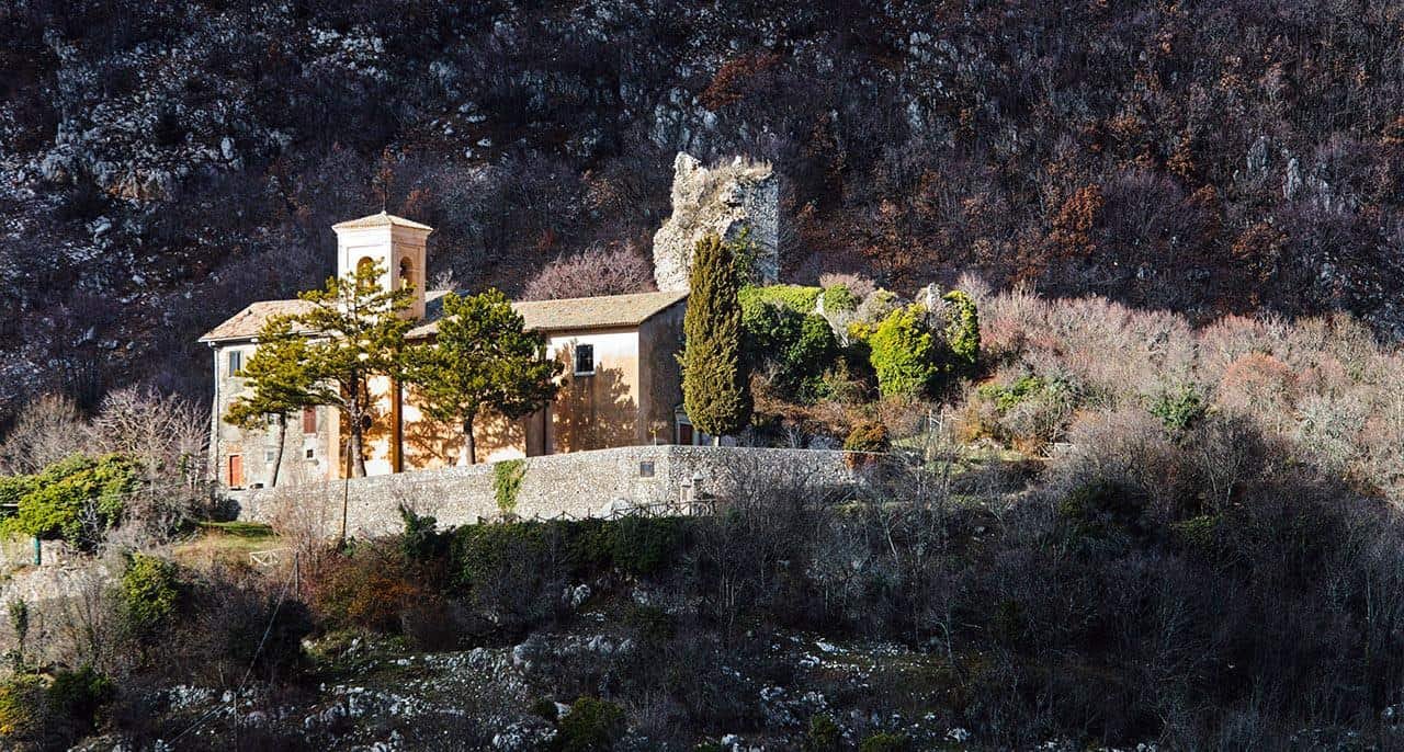
A large park extends around the castle, and in the park grow the century-old cedars of Lebanon that the municipality wanted on its coat of arms next to the fortress. A cedar of Lebanon at 840 meters in the Apennines is an exotic plant, planted for show in an era when the parks of noble villas were botanical collections. Its presence tells the residential phase of the castle better than any fresco. From the approach road, when the right curve opens the field of view, you see the compact mass standing out from the green of the woods, the dark crowns of the cedars next to the towers and below the orderly cascade of roofs. It's an image you can read in a single glance: hierarchy, protection, belonging.
Why Orvinio Castle can't be visited, and why it's not a tragedy
The castle bears the name of its current owners, the Malvezzi Campeggi family, a Bolognese house of ancient nobility, and it is private property. The upper rooms are made available for ceremonies, weddings and meetings, and in summer sometimes for hospitality, but there is no ticket office or opening time. This produces a paradoxical situation: the most seen monument of Orvinio is the least visited. The frustration is understandable but wrong. The castle isn't interesting because you can go inside. It's interesting because it defines the space. It's an urban object before being a container of rooms. Its value for the visitor lies in the way it organizes the perspectives of the village, dominates the views from the valley floor and changes color with the light of the different hours. Whoever arrives with an admission-ticket mentality loses all this. Whoever arrives with the mentality of an urban observer finds it extraordinary.
A curious note: in mountain communities the castle wasn't perceived as a cultural asset but as a master. For centuries the relationship between the town and the manor was a relationship of economic dependence, of feudal obligations, of services owed. The romantic rhetoric of the enchanted castle is a 1800s product imported from outside. The townspeople, historically, had much more ambivalent feelings toward that mass. Knowing this, while looking from below, adds a level of reading that no panel will ever give you.

The churches of Orvinio (RI), one by one
For a town of 400 residents Orvinio has a disproportionate religious heritage: two churches in the village, a deconsecrated church, a sanctuary two kilometers away and the ruins of an abbey. The reason is simple: between the 1500s and 1600s the town was a center of government of the Papal States with a rich feudal lord, and had a painter of good level at home. The churches should be seen in this order.
San Nicola di Bari, the parish church of Orvinio
The parish church, dedicated to San Nicola di Bari, is the result of a reconstruction in 1842 in late Baroque forms on a 1500s church, which local sources date to 1536. It is the religious building that holds up the life of the town. The patron saint festival is celebrated here in the second half of August and the Good Friday procession, one of the most heartfelt traditions of the village, starts from here. Architecturally it is a church of the papal 1800s, sober, with a bright interior that favors the readability of the altar. It's not the masterpiece of Orvinio, and I say it without embarrassment, but it's the place where you understand the living town, the one of families and bells. Go in there first, when the door is open on Sunday morning.
Santa Maria dei Raccomandati and the frescoes of Vincenzo Manenti
Santa Maria dei Raccomandati is the church worth the visit. It was built in 1582 just outside the walls, in the upper part of town, as the church of a Franciscan convent that also served as a hospice. A document from 1638 still calls it the convent of Canemorto. In 1653, under Innocent X, the convent was suppressed in the great reform of small convents that pope wanted, and reopened only when the municipality committed to supporting the friars financially. The facade was redone in neoclassical forms. The interior has a single nave with side altars, and the cloister survives next to it, facing the countryside. But the reason you go in is the frescoes by Vincenzo Manenti, the painter born in Canemorto around 1600, who decorated the whole church in the 1660s, in the last season of his life: cycles with saints, the theological virtues and figures of cardinals, and on the main altar the canvas with the Madonna dei Raccomandati. Manenti had studied with his father Ascanio, then in Rome in the workshops of the Cavalier d'Arpino and of Domenichino, and had worked in the cathedral of Tivoli. What you see here is a cultivated provincial Baroque, well drawn, with the light colors and orderly compositions he had learned from Domenichino. Don't expect Caravaggio. Expect a painter who knows the trade and who decorates the church of his own town with evident affection, and judge him by that.
The title Raccomandati deserves an explanation, because most visitors walk through it without asking what it means. The Raccomandati were lay confraternities widespread in central Italy since the late Middle Ages: associations of ordinary men and women who formally placed themselves under the raccomandazione, meaning the protection, of the Virgin. Behind the devotional formula there was a social machine. The confraternity collected dues from its members, administered an estate, guaranteed a decent burial to its enrolled members, assisted widows and orphans, lent money in non-usurious forms, organized processions and festivals. In a town at 840 meters, where winter closed the roads and a bad year could mean hunger, this structure was the social protection system. There was nothing else. The iconography of the Madonna with her cloak open welcoming kneeling believers, which today we read as tender, was an institutional manifesto: the cloak is the coverage, the believers underneath are the members in good standing with their dues. Look at the coats of arms, the inscriptions, the floor memorial stones with these eyes. They almost always tell of growth in the 1500s and 1600s, a crisis in the 1700s and a reorganization after unification. The history of a confraternity is the history of Italy in miniature. And if you happen to be in Orvinio on Good Friday and see a group come out with capes and banners, you are witnessing the continuation of a practice that is centuries old. It's not folklore reconstructed for tourists.
San Giacomo, the octagonal church attributed to Bernini
In the historic center stands the church of San Giacomo, now deconsecrated, built between 1612 and 1614 on an octagonal plan. Local tradition, taken up by the association of the Most Beautiful Villages in Italy, holds that it was built on a design by Bernini. It has to be said clearly: in 1612 Gian Lorenzo Bernini was 14 years old and his father Pietro had just arrived in Rome from Naples, so the attribution, if it has any basis, should be referred, if anything, to a workshop or to a later project, and it remains a tradition, not a document. What is certain, instead, is the octagonal central plan, unusual for a mountain town and clearly inspired by Roman models of the early 1600s. It's the sign that the Muti, feudal lords in those years, wanted to bring to Canemorto a piece of court architecture. The building is viewed from the outside and, when it's open for exhibitions and events, from the inside.
The Sanctuary of the Madonna di Vallebona
About two kilometers from town, on the site of the ancient village of Vallebona, stands the sanctuary of the Madonna di Vallebona, built around 1643 with only the contribution of alms offered spontaneously by the population. The founding legend is the classic one of Apennine Marian sanctuaries: a shepherd finds an image of the Virgin, the image is carried to town, returns mysteriously to its place and the community understands that the Madonna wants her church there. The building has a rectangular plan, one nave, with a roof of wooden trusses, and preserves decorations attributed to Vincenzo Manenti, who in the same years was working for the town. In 1727 the Madonna di Vallebona was declared protector of Orvinio. The sanctuary is isolated, surrounded by woods and meadows, and the road that takes you there is one of the finest walks in the area. It's my number one recommendation for anyone with three hours who wants to understand the relationship between Orvinio and its mountain. Check opening times with the parish, because outside the feast days the sanctuary may be closed.

The ruins of the abbey of Santa Maria del Piano
In the Valle Muzia, about two kilometers from the center, stand the imposing ruins of the church and monastery of Santa Maria del Piano in Sabina. Tradition says it was founded by Charlemagne in 817 after the victory over the Saracens that supposedly gave Canemorto its name. Historians date it more cautiously to the 11th century, in the full swing of Benedictine expansion, and its 12th-century bell tower, with refined decorative elements, is the best-preserved part. Leo X, the Medici pope, raised it to a commendam in the early 1500s, meaning he entrusted it to a prelate who collected its revenues without living there: the formula that emptied half of Italy's abbeys. From then on the decline was steady, down to the present ruins. Visiting is free, the place is silent and a little melancholy, and I recommend it in the late afternoon, when the raking light enters between the walls and the bell tower casts its shadow on the meadows. The abbey pairs naturally with the great mother house of Sabine monasticism, the abbey of Farfa, whose landholding power in the early Middle Ages extended over this whole mountain.
A thing nobody tells you about Orvinio (RI)
Here the list ends and the part begins with the things you don't find in official descriptions. Not because they're secret, but because they're uncomfortable, or hard to use in a brochure, or too long to explain in a caption. They're exactly the things that make the difference between someone who comes back from Orvinio saying "cute" and someone who comes back saying they understood something.
Orvinio is beautiful and it's emptying out, and the two things coexist
The first thing nobody tells you is the hardest, and it's demographic. Orvinio, with its roughly 390 residents, like practically all the municipalities of the central Apennines below the threshold of 1,000, is inside a trajectory of structural depopulation that has lasted over a century. The average age is high, births are very few, the school is a permanent problem, health services require travel, and every year a few more houses stay closed. This fact doesn't appear in tourist presentations, and I understand why. But keeping quiet about it is a mistake, for two reasons. The first is that the attentive visitor notices anyway. The second is that knowing it changes the way you visit. If you know that bar is one of the last commercial outposts in town, you go in and buy something. If you know that lodging is the investment of someone who chose to stay, you book it instead of sleeping in the city. Conscious tourism isn't a moral label, it's a behavior with measurable effects.
Then there's a paradox that has to be said: much of the beauty we admire in Apennine villages is a byproduct of poverty. These towns are intact because there was no money to demolish and rebuild them in the 1960s and 1970s. The exposed stone we find authentic today was, for those who lived there, the sign of not having been able to plaster. The small windows we call characteristic were the compromise between light and heat loss in houses without heating. I don't say this to diminish the beauty, which is real. I say it because understood beauty is deeper than consumed beauty. And the practical consequence is that the building stock has an enormous maintenance need and a tiny tax base. When you see a construction site in a village, it's never a detail, it's a battle.
The closed castle and misplaced disappointment
The second thing concerns the relationship between the visitor's expectations and private heritage. Whoever arrives convinced that every Italian castle has a ticket office experiences a small frustration, and from this frustration come the negative reviews you read online. I want to say something unpopular: that frustration comes from a cultural misunderstanding. In Italy a gigantic share of the historic heritage is in private hands, and it got there through centuries of continuous ownership or through acquisitions after the dissolution of feudal systems. This heritage is standing precisely because someone took charge of it. A maintained private castle is infinitely better than a public castle in ruins, and there are dozens of those. I'll add an operational detail: when there are special openings, concerts or cultural initiatives involving the castle, the announcements go out on the channels of the municipality, the Pro Loco and the Orviniando association, not on the big portals. If your goal is to get in, the strategy is to follow those channels and make the visit coincide with an event. It's the only method that works.
The mountain is real, and it has consequences
The third thing is that Orvinio, despite its closeness to Rome, is in every respect a mountain town. 60 kilometers from the capital creates an illusion of proximity that is dangerous, because it induces hillside-outing behavior in an Apennine setting. In winter the roads can be icy even when it's raining in Rome. Fog on the passes reduces visibility in a few minutes. In summer, after a hot day, afternoon thunderstorms on the high ground are frequent and can be violent. The sun sets behind the mountain well before the official time, and darkness in a gully arrives suddenly. And the trails of the Lucretili aren't strolls. They are mountain routes with elevation gains that easily exceed 500 or 600 meters, stretches in dense woods where orientation requires attention, and surfaces that become slippery after rain. Monte Pellecchia, at 1369 meters, is the highest peak of the group and climbing it takes training, time, water and equipment. Every year people in sneakers set out in the early afternoon without a flashlight and without a map, and every year some of them create a serious problem for themselves and for the rescuers. If you want to approach it gradually, start with the gentler routes in the Percile area.
Silence is the real product, and you have to know how to consume it
The fourth thing is that the main asset Orvinio offers is not the castle, not the church, not the view. It's silence, and silence is a product that most contemporary visitors no longer know how to consume. We're used to experiences with high information density: screens, notifications, constant stimuli. In a low-density environment the instinctive reaction is boredom, and the reaction to boredom is to pull out the phone. The result is that you cross an extraordinarily silent place without perceiving its silence, because you fill it right away. To consume silence you need a small protocol. First: phone in your pocket for at least half an hour. Second: sit down, because walking makes noise. Third: give your ear 10 or 15 minutes to recalibrate. Fourth: identify the sounds one by one. A dog at the far end of the valley. An engine that climbs and shuts off. The wind in the beech woods, which has a different sound from the wind in the oaks. A bell. When you get to telling apart the wind among leaves from the wind among dry branches, you've finished recalibrating and you're finally listening. An afternoon in Orvinio listened to well stays in memory for years. The same afternoon crossed with headphones doesn't stay at all.
The extreme seasonality of Orvinio
The fifth thing concerns how violently this town changes between high and low season. In August Orvinio is a living place, with the fair of the 19th, the festival of San Nicola, people in the street, businesses open, children. In February, on a Tuesday afternoon, it can be a town where you meet four people in two hours. Neither version is the real one. They're both real. Whoever looks for the lively village and arrives in January thinks the town is dead. Whoever looks for silence and arrives at Ferragosto thinks it's overrated. You have to choose which Orvinio you want. The suggestion, for those who can, is to try both. The comparison between the summer town and the winter one shows the double nature of these places, very small permanent communities that periodically host much bigger seasonal communities. It's the real way inland Italy lives today.
The name, again: what it means to change identity
The sixth thing returns to the question of the name, from a different angle. A change of name is a deep intervention on a community's identity, and the effects are seen generations later. When a town changes its name out of shame it performs an act of removal, and removals don't eliminate but displace. The old name keeps existing in oral memory, in nicknames, in jokes, in archive documents, in old maps. It becomes a second, underground name that resurfaces when it's needed to mark belonging. The 1993 coat of arms with the rampant dog is exactly this resurfacing. And today, in the era of territorial marketing, that removed name has become an advantage: Canemorto is memorable, it's strong, it intrigues, it tells well. What one generation considers improper, another considers identity.
The truth about the economics of the beautiful village
The seventh thing concerns the economic model. Recognition among the Most Beautiful Villages in Italy is a quality mark that generates visibility, not funding and not a guarantee of sustainability. The tourist flow it generates is highly concentrated: a handful of weekends a year plus the summer period, and eight or nine months left uncovered. For a local operator this means holding on with seasonal revenue and annual fixed costs, and it's the reason why in many villages businesses open and close with a frequency that surprises. It also means that the single visitor carries a greater relative weight than in a city: in a village of 400 residents, where you eat lunch, where you sleep, what you buy and how many times you come back are variables that really count. It's not rhetoric, it's arithmetic applied to small numbers. Hence the recommendation, which holds for Orvinio as for Casperia or Castel di Tora: if you like a place, go back. The difference between passing-through tourism and a stable relationship with a territory is, literally, the difference between a town that empties out and a town that holds.
The band-shaped village of Orvinio: the gate, the arches, the portals
Orvinio is not circular, not gridded, not spiral. It's linear, laid out along the slope, organized by contour lines. What architectural historians call a row settlement along a contour line. The houses line up following the slope instead of opposing it, share walls, and use the difference in level to have entrances on different floors. Building on a steep slope carries an enormous cost in excavation and foundations. Building along the contour line reduces it drastically, because each row of houses works at a constant elevation and the drop between one row and the next is absorbed by retaining walls and staircases. The result is a structure of inhabited terraces, where the roof of the lower row is almost at the level of the street of the upper row, and the houses of rough stone blocks still have the fortified look that the castle walls imposed.
The gate of Orvinio and the town walls
You enter the old village through the gate that opens in the crenellated walls of the castle, the same walls that embrace the historic center and that are one of the oldest elements of the whole. Stop under the arch and look up: the masonry of irregular ashlar blocks, the crenellation, the narrow passage meant for one cart and not for two. The gate is the first device of the town and it declares its nature right away: here you entered under control. After the gate the paving climbs, and it keeps climbing.

Two effects of the band-shaped town
The first effect is visual. From below the town appears as a single compact organism, a continuous wall mass from which the bell towers emerge and over which the castle looms. From above you see an orderly succession of roofs and the eye runs along the slope down to the valley. They are two different experiences of the same object, and it's the reason you have to walk Orvinio in both directions. The second effect is social. In a band-shaped settlement the houses share walls and the alleys are very narrow, private life and public life have a thin border, you hear your neighbor, you cross paths several times a day, there is no anonymity. Communities of this type developed refined codes of behavior to manage this closeness. The obligatory greeting, the formal discretion, the mutual social control are not character traits, they are architectural adaptations.
Buttress arches, drainage channels and dated portals
Whoever visits with attention notices the technical details this structure imposes: drainage channels cut into the paving to handle the water coming down the slope, buttress arches thrown between one house and the next to counter the movements of the ground, cellar openings at different levels from the entrance door because the difference in elevation allows multiple accesses to the same building. These are vernacular engineering solutions accumulated over centuries of trial and error, and they still work. The only display allowed to families who otherwise built soberly is concentrated in the portals: dated lintels, worn coats of arms, monograms, incised crosses. Look for them. Whoever arrives expecting the postcard village with the perfect little square and the bougainvilleas is left disoriented. Orvinio is a mountain village, gray stone, wood, pitched roofs, small windows, sober colors. The beauty isn't in the decoration, it's in the coherence. It asks for one more minute to be recognized, and for that very reason it lasts longer in memory. Whoever wants to compare this model with other villages in the same area should look at Collalto Sabino, which shares with Orvinio the logic of the dominant castle, or at Casperia, which represents the concentric spiral model, completely different.
The advice I give you for visiting Orvinio (RI)
The main advice is as simple as it is counterintuitive: don't arrive in Orvinio at noon. I know it's the most convenient time, I know a day trip is organized around lunch, and I know everybody does it that way. That's exactly why it's better not to. At noon the sun is high, the light is flat, the castle loses the relief of its masonry and the photographs come out badly. Arrive early in the morning or after four in the afternoon. The village you'll see will be a different village.
Walking Orvinio twice
You go through Orvinio twice, and it's not a waste of time, it's method. The first time you go up, from the lower parking area through the gate to the high points below the castle and to Santa Maria dei Raccomandati. The second time you go down, retracing the same fabric in the opposite direction. 90 percent of the details you'll notice going down you hadn't seen going up, because climbing you look at your feet and the paving, while descending you look ahead and up, toward the facades, the lintels, the arches. They're two towns superimposed in the same space.
Don't build the day on the castle
Don't plan getting into the castle as the goal of the day. I repeat it because it's the main source of disappointment. Build the day on the village, on the sanctuary of Vallebona, on the abbey of Santa Maria del Piano, on the landscape and on the trails. If then the chance of an opening or an event comes up, it will be an extra gift. An itinerary that depends on a door that might be closed is a badly built itinerary, and the fault isn't the castle's.
20 minutes sitting and doing nothing
Find a low wall, a bench, a wide spot with a view over the valley, and stay there for 20 minutes. No phone, no map, no photographs. It sounds like advice from a meditation manual and it is instead technical advice on observation: it takes at least 15 minutes for the ear to get used to the sound level of a mountain town and begin to tell individual sounds apart. Before that moment you hear only generic silence. After, you hear the town.
Just one more thing, not three
Orvinio alone doesn't fill a day, and this has to be managed instead of denied. The worst solution is to add three more villages and turn the day trip into a tour de force of parking lots. The best solution is to pair Orvinio with a single complementary element. If you're looking for nature, the trails of the Lucretili start a few minutes away by car. If you're looking for water and a view, Lake Turano. If you're looking for another village with a different character, Collalto Sabino, at a reasonable distance, offers a very interesting comparison between two models of fortified town. If you're looking for literature, the Licenza valley with Horace's villa is on the way back.
Eating in Orvinio by reservation
Here we are in the territory of Apennine cooking: grilled meats, sheep cheeses, legumes, handmade pasta with hearty sauces, porcini mushrooms and truffles in season. Sabina olive oil, which has a history that spans millennia, is the protagonist and not a supporting player. If you can buy some from a producer in the area, do it. The difference from the industrial product is clear even to an inexperienced palate. But my operational advice is not to improvise. In towns of this size there are few places to eat and capacity is limited. In high season showing up without checking availability often means being left stranded, and in low season the risk is even higher because some businesses keep closing shifts. Always check first. It's a banality, but it's the banality that saves days.
With kids, with a backpack and in the right season
Orvinio works very well with children on two conditions: no stroller, because the uphill alleys and the stairways make it an ordeal, and a visit turned into a treasure hunt, with a list of things to find: dated portals, mascarons, horse rings in the walls, cats, fountains, inscriptions. For those who come to hike seriously: the park trails are well marked but not trivial. Bring plenty of water because the water sources at altitude aren't always reliable, bring a real map in addition to your phone, and don't improvise the climb of Monte Pellecchia without training. On the season: if you come only once in your life, come in October. The beech woods in October are one of the most beautiful natural spectacles in Lazio, the town is quiet, the temperatures are perfect for walking, the raking afternoon light sculpts the stones, and the morning mist in the valley floor produces those images of a castle floating above the clouds that look fake and aren't.
Talk to someone
The most valuable advice, the one nobody follows: talk to someone. Don't interview, don't ask journalist questions. Say hello, comment on the weather, say it's your first time here. In Apennine towns the greeting is still a social obligation and conversation with a stranger is still a normal practice. In 10 minutes of chatting with a resident you'll learn about this place more than any panel will tell you: which road collapsed last winter, where the sunset is best seen, which festival is worth it. And if you want to really open a conversation with an elderly person from Orvinio, ask about the maestro. You'll see what happens. For those who prefer to be accompanied by a professional, with a tailor-made itinerary and no worries, the formula of the private experiences for small groups by TourLeaderPro also covers days outside Rome.
If I had to reduce everything to one sentence to jot down before leaving: arrive early or late, walk twice, eat by reservation, add just one thing, sit for 20 minutes and talk to someone. Do it and Orvinio will give you back much more than a village of 400 residents is obliged to give you.
Another well-known fact, yet rarely mentioned
That Orvinio gave birth to a painter everyone in town knows and every panel says: Vincenzo Manenti, born in Canemorto around 1600 and died here in 1674. What's mentioned less is the trajectory of this painter, which explains why a mountain village has churches decorated like a provincial city. Manenti learned the first rudiments from his father Ascanio, also a painter, and then went to Rome, where he was a student of the Cavalier d'Arpino, Giuseppe Cesari, the master through whose workshop Caravaggio had also passed, and of Domenichino, the Bolognese who in the Rome of the early decades of the 1600s represented the classicism of the Carracci. From this double training came a solid painter, capable of large mural cycles and of portraits. He worked in the cathedral of Tivoli, where he painted frescoes and the portraits of Cardinals Giulio Roma and Marcello Santacroce, he painted a canvas of Saint Francis Xavier for the Jesuits, now lost, and he worked for Santa Maria Nova in Toffia, in the Sabina, where his works were destroyed in a fire. Then he came home, and in the 1660s, by then 60 years old, he decorated the whole of Santa Maria dei Raccomandati and left traces in the sanctuary of Vallebona. A Roman artist who chooses to end his career in the mountain town where he was born, and to give it the best of his craft: this is the well-known and rarely mentioned fact.
The second rarely mentioned fact is that Orvinio was for 60 years an Umbrian municipality. After unification the district of Rieti was assigned to the province of Perugia, and Orvinio, with the whole mandamento, remained administratively in Umbria from 1861 to 1923, when it passed to the province of Rome. Only in 1927, with the creation of the province of Rieti, did the current arrangement arrive. It's a fact that explains the town's suspended identity, and visitors almost always find it incredible. The third fact is that besides Manenti, an engraver and a novelist come from Orvinio: Giovanni Girolamo Frezza, an engraver active in Rome between the 1600s and 1700s, born here in 1659 and died in 1749, and Virgilio Brocchi, born in Orvinio on January 19, 1876 and died in Sant'Ilario di Genova in 1961, author of about 50 popular novels that in the first half of the 1900s were the best sellers of the era, an outspoken socialist and friend of Filippo Turati. Three men of culture from a town of 400 residents: the proportion is that of a city.
The Cammino di San Benedetto and the trails of the Monti Lucretili from Orvinio (RI)
Orvinio is today a stop on the Cammino di San Benedetto, the 305-kilometer route on foot (345 by bicycle) in 16 stages devised by Simone Frignani that connects Norcia, where Benedict was born, to Subiaco, where he lived as a hermit, and to Montecassino, where he founded the abbey and died. Stage 8 arrives in Orvinio from Castel di Tora, on Lake Turano, with 13.5 kilometers of ups and downs through the woods. Stage 9 leaves Orvinio toward Mandela and Vicovaro, in the Aniene valley, with 20.1 kilometers almost all downhill. Whoever walks the Cammino sleeps in Orvinio. It's the highest stage of the route in Lazio, and for a pilgrim arriving from the Turano the castle that appears above the beech woods is one of the images that stay with you. Even those who don't do the whole Cammino can walk one of the two stages in a day, with a car left at one end and a ride to the other. Personally I recommend the stage from Castel di Tora, uphill, which gives you the lake at the start and the village at the end: the right sequence.

The Monti Lucretili Park seen from Orvinio
Orvinio sits on the northern edge of the Monti Lucretili Regional Natural Park, which is headquartered in Palombara Sabina and includes 15 municipalities between the provinces of Rome and Rieti: Licenza, Marcellina, Monteflavio, Montorio Romano, Moricone, Nerola, Orvinio, Palombara Sabina, Percile, Poggio Moiano, Roccagiovine, San Polo dei Cavalieri, Scandriglia, Vicovaro and Mandela. The Lucretili are a limestone massif that acts as a hinge between the Roman countryside and the real Apennines, and because of this threshold position they host an overlap of environments rarely found in so few kilometers: olive groves and Mediterranean scrub in the lower bands, oak and hornbeam woods at intermediate elevations, mature beech woods above 1,000 meters with maples of enormous size, summit grasslands on the peaks.
Monte Pellecchia and the golden eagle
The reference peak is Monte Pellecchia, 1369.8 meters, the highest peak of the group, followed by Monte Gennaro at 1271. On the southeastern walls of the Pellecchia, golden eagle nesting is confirmed. It's the nesting site closest to Rome, a little over 50 kilometers from the Colosseum, and by itself it justifies the existence of the park. From the summit, on clear days, you take in a portion of territory that runs from the Umbrian ranges to the Rieti basin, from the Terminillo to the Abruzzo peaks. It's not a trivial climb: it requires training and equipment, but it's the reason many hikers choose Orvinio as a base instead of better-equipped towns.
The beech woods, four places in one
The beech woods of the Lucretili are the least-told asset of the whole area. A mature beech forest isn't a set of trees. It's an environment with its own acoustics, its own light, its own temperature. In summer, entering a beech wood means losing six or seven degrees in a few steps and finding yourself in a green half-light filtering from above. In autumn the same wood becomes a golden chromatic chamber. In winter, without leaves, it reveals the geometry of the gray trunks and the structure of the ground. Whoever walks here in all four seasons is in fact walking in four different places. If you're planning the hike from abroad, you'll find a general picture of Italian mountains on the ItalyPlanner page dedicated to mountains and nature in Italy.
Olive groves, pastures and the boundary line
Going up from Rome you cross the band of Sabine olive groves, one of the oldest cultural landscapes of central Italy, where the olive tree isn't a crop among others but the very structure of the territory, with centuries-old plantings, terraces and dry-stone walls on entire slopes. Then the olive tree gives up to the elevation and yields to woods and pasture. Orvinio sits exactly on the line of this transition, and this frontier position explains its material culture: a cuisine that mixes the oil of the olive grove with the meat of the pasture, a calendar that holds together the autumn harvest and the transhumance, a mentality that looks downward and upward at the same time. When you walk on an olive terrace in the Sabina, very often you're walking on infrastructure designed by an abbot. The monastic presence of Farfa and its dependencies shaped agriculture, roads and land ownership so deeply that even today, looking at a cadastral map, you can read in faint outline boundaries that go back to early medieval donations.

The right photo to take in Orvinio (RI)
Let's talk about photography seriously, because Orvinio is one of those places where the difference between a banal photograph and a memorable one depends not on equipment but on three decisions: where you stand, at what time, in which direction you look. The right photo, the one that really tells this place, is the castle emerging above the band of roofs, shot from outside the town, with the dark crowns of the cedars next to the towers and the woods closing the scene on the sides. You don't take it inside the village. You take it from the approach road or from one of the viewpoints on the opposite side of the basin, and it requires that you stop before arriving instead of aiming for the parking lot. It's the classic mistake of the hurried visitor: he drives past the best view while looking for a spot for the car, promises himself he'll come back, and on the way back it's dark. So, first rule: when you're climbing and the curve opens the view onto the town, stop in a safe pullout and get out. That's the photograph. Take it on arrival, not on departure.
The right time to photograph Orvinio
The light that works is that of late afternoon, when the low sun comes raking across the slope and separates the volumes. The castle gains three-dimensionality, the facades split into lit and shaded parts, the woods lose their green uniformity and show the structure of the crowns. At noon you get an indistinct gray mass resting on an indistinct green mass. But there's a second window that few use: the first hour after dawn on autumn days, when the cold night air pools on the valley floor and produces a lake of fog that dissolves after sunrise. If you're on a high point at that moment you see the roofs and the castle emerge from a white sea. It requires getting up in the dark and driving on cold roads. Do it once and you'll understand why I insist.
Focal length: telephoto, not wide-angle
The wide-angle lens is the enemy of villages seen from afar. It widens the field, shrinks the subject and turns the castle into a detail inside a generic landscape. You need a mid telephoto, between 80 and 200 millimeters equivalent, which compresses distances and stacks the planes: the woods in the foreground, the houses in the middle, the castle above, the mountain behind. That compression is exactly the feeling you get looking at Orvinio in person. Inside the village the opposite rules apply. In the narrow alleys the wide-angle becomes useful again, but with discipline. Look for the alley that frames something at the end: a piece of the castle, a bell tower, a patch of valley, an arch. An alley that ends in nothing is a boring photograph.
Arches, portals, sanctuary and woods
A hugely underrated subject is the buttress arches between opposing buildings. They create a natural frame, generate a strong contrast between the shaded area under the arch and the lit one beyond, and give depth. There are more of them than you think and nobody photographs them. Then the thresholds and portals: photographed head-on, in diffuse light, they become a coherent series. Make a collection, 10 portals, same setup, same distance: a visual archive worth more than 10 generic views. The sanctuary of Vallebona, isolated in the meadows with the mountain behind, is the right subject for mid-afternoon light, and the bell tower of Santa Maria del Piano for the raking light of the evening. And the woods: a mature beech wood, with parallel gray trunks and the ground covered in leaves, works in color in autumn and in black and white all year, in the light of a slightly overcast day. Full sun inside a beech wood almost always produces unreadable images.
Close-ups, weather and courtesy
Use close-ups: a branch, a dry-stone wall, a stretch of fence in front of the view of the town turn a postcard into a photograph and give scale and depth. On weather, counterintuitive but true: perfectly clear days aren't the best, because a blue sky is an empty surface. Days with moving clouds, clearings, residual fog, storms coming or just passed produce the strong images. In the Apennines the best photos are often born on days that look bad on paper. For those who want to widen the repertoire in the same day: Lake Turano with the villages hanging above the water, the Percile lakes with their reflections and riverside vegetation, Casperia with its spiral plan. Three places, three visual grammars. Last recommendation, an ethical one: in small towns people are not subjects at your disposal. If you photograph someone, ask. The best photographs almost always come from a relationship, not from an ambush.
The ideal strategy for a day: arrive in the late afternoon and stop at the scenic curve for the overall view with the telephoto lens. Enter the village and work on the alleys, arches and portals while the light drops. Head out to a high point for the sunset over the castle. If you sleep in the area, set the alarm before dawn for the fog on the valley floor. Four moments, four kinds of image, one complete story.
Some important events that happened here in history
The chronology of Orvinio is a sequence of dates that tell, one by one, the passage from destroyed village to papal fief to mountain municipality. I put them in order and distinguish, as always, what is documented from what is tradition.
From 817 to 1632: the legend and the feudal lords
In 817, according to tradition, Charlemagne's soldiers defeated the Saracens in the valley and founded Santa Maria del Piano. It's a founding legend, but it's the date with which the town tells its own story. Before the year 1000 the ancient settlement was destroyed, and the new village of Canemorto gathered on the height of the castle under the protection of the Benedictines, documented in the 11th century in the abbey of Piano. In the 1400s the Orsini built the Granarone and in the 1500s they enlarged the castle, while the town grew by taking in the inhabitants of the neighboring villages that were being depopulated. In 1536 the first church of San Nicola was built. In 1582 the church and Franciscan convent of Santa Maria dei Raccomandati, outside the walls. Between 1612 and 1614 the Muti had San Giacomo built, on an octagonal plan. In 1632 the fief passed to the Borghese, who made it a duchy.
1643, 1653, 1727: the 1600s and 1700s of devotion
Around 1643 the population built the sanctuary of the Madonna di Vallebona with alms alone. In 1653 Innocent X suppressed the convent of the Raccomandati along with a great many small Italian convents, and the municipality of Canemorto committed to supporting the friars in order to have it reopened. A mountain town paying out of its own pocket to keep the Franciscans is an event more eloquent than many battles. In the 1660s Vincenzo Manenti frescoed the whole church of the Raccomandati. In 1727 the Madonna di Vallebona was proclaimed protector of the town.
1842, 1843, 1863: the 1800s that change the face and the name
In 1842 the parish church of San Nicola was rebuilt in its current late Baroque forms. In 1843 the castle was renovated. In 1860 the Papal States ended in this part of the Sabina and in 1861 Canemorto became the seat of a mandamento in the district of Rieti, province of Perugia. In 1863 the municipality obtained the name Orvinio.
August 31, 1872: the Orvinio meteorite
At a quarter past five in the morning on August 31, 1872, a meteorite broke apart in the sky over Orvinio and the fragments fell on the municipal territory. It's the most incredible event in the town's history and the one almost nobody mentions. The fall was documented by the scientists of the time, the collected fragments ended up in mineralogical collections, and the Orvinio meteorite, classified as an H6 ordinary chondrite heavily shocked, is still studied today by planetary scientists. A 2004 article in the journal Meteoritics and Planetary Science analyzes its structure to understand the evolution of the asteroids from which the H chondrites come. A sample is kept in the Mineralogy Museum of Sapienza University of Rome. The scientific name of the meteorite, in international catalogs, is simply Orvinio: the town that had given itself a new name just nine years earlier saw it enter the catalogs of world science thanks to a rock fallen from the sky.
1915-1918, 1923, 1927: the 1900s
Between 1915 and 1918, in the middle of the war, restorations in the castle brought skeletons to light in the cellars, according to local tradition. In 1923 Orvinio passed from the province of Perugia to that of Rome and in 1927, with the creation of the province of Rieti, to the current province. Then came the Second World War, with the Apennines crossed by evacuees, escaped prisoners and roundups, and the postwar emigration that emptied the town. In 1993 the municipality adopted the coat of arms with the castle, the cedar and the rampant dog. Entry among the Most Beautiful Villages in Italy and the second place in Lazio at the FAI Luoghi del Cuore in 2019 close the chronology, for now.
Who has passed through Orvinio (RI)
When you talk about who has passed through an Apennine village of 400 residents, the temptation is to inflate the story with high-sounding names. I prefer the opposite: to tell who really passed through, individuals and flows, because the history of a place like Orvinio is made of both.
The Aborigines, the Sabines and the Romans of Horace
The first were the Aborigines of the Orvinium of Dionysius of Halicarnassus, then the Sabines, the Italic people of mountains and shepherds whose imprint is that of drove roads, developed springs, mountain sanctuaries. Then the Romans, in massive numbers: the Aniene valley and the Sabina were the hinterland of the City, from here came water, stone, timber, livestock and oil, and here the ruling class built its vacation villas. The most famous is Horace's villa at Licenza, in the valley you go up to reach Orvinio. The poet who sang of the retired life, of measure, of the corner of land that is enough for a man, did it from these slopes. The hills you see from Orvinio toward the south, those that descend toward Licenza, are the same ones Horace had before his eyes. It's not a suggestion, it's geography.
Monks and lords: Benedictines, Orsini, Muti, Borghese
Then the monks passed through. From the early Middle Ages the Sabina was one of the great laboratories of Benedictine monasticism. Farfa dealt as an equal with emperors and popes, and the dependency of Santa Maria del Piano organized the valley of Orvinio. The monks didn't just pass through. They drained land, broke up soil, built churches and mills, drew up land registers. Then the lords passed through: the Orsini, the most powerful Roman baronial family of the 1400s and 1500s. The Muti, who wanted an octagonal church in the Roman style. The Borghese, the family of Paul V, who bought the fief in 1632 and held it as a duchy. And today the Malvezzi Campeggi, the Bolognese house that gives the castle its name and maintains it.
Manenti, Frezza, Brocchi, Forte: those who left Orvinio
Then there are those who left Orvinio. Vincenzo Manenti, the painter, went to Rome to the Cavalier d'Arpino and Domenichino and came back to decorate the churches of the town. Giovanni Girolamo Frezza, born here in 1659, was an engraver in Rome and died in 1749. Virgilio Brocchi, born in Orvinio on January 19, 1876, became one of the most-read novelists of Italy in the first half of the 1900s, with a novel a year and titles like La Gironda in 1909, Il labirinto in 1913, Le aquile in 1919. He died in Sant'Ilario di Genova in 1961. Natalino Forte, a poet and writer who lived between 1926 and 2011, published works in the Orvinio dialect, the Sabine speech of this town, and committed it to writing before it disappeared.
Brigands, travelers and the armies of the 1900s
Then the brigands passed through, and here we have to be honest because tourism romanticizes too much. Between the 1700s and 1800s, and intensely in the post-unification period, the mountains between Lazio, Abruzzo and the Kingdom of Naples were the theater of an endemic banditry with deep social roots: poverty, conscription, the crisis of pastoral economies, political tensions. Apennine villages lived through this season with fear and ambiguity, because the brigand was at once a predator and, sometimes, a relative. Then passed, to a lesser extent than in Tivoli and Subiaco, the travelers of the Grand Tour, painters and engravers looking for scenic landscapes, whose notebooks document the look of villages before contemporary transformations. Then, and it's the most painful page, the armies of the Second World War. Mountain towns were a refuge for evacuees, escaped prisoners, draft evaders and partisans, and for that reason the object of repression. Every municipality in this belt has its memory of those years, kept in a plaque or in a family story.
Emigrants, teachers, pilgrims and hikers
Then the emigrants passed through, and they keep passing through. From the late 1800s to the 1970s the towns of inland Lazio emptied out toward Rome, the north and the Americas, and every summer part of those family branches comes back, filling the closed houses. The summer tourism of Apennine villages, before being tourism, was for decades a homecoming. And then the teachers, the municipal doctors, the parish priests and the carabinieri, the four figures who in the 1900s represented the State in mountain towns, coming from far away and staying for decades. Today the pilgrims of the Cammino di San Benedetto pass through, sleeping here between the Turano stage and the Aniene stage. The hikers of the Lucretili. The cyclists, because the lightly trafficked provincial roads with plenty of elevation change are a paradise for road bikes and gravel. The autumn photographers. And the silence seekers, a new category that includes those who work remotely and those looking for a house to restore. Finally pass the village collectors, those who follow the list of the Most Beautiful Villages like a list to check off. My invitation is to use the list to choose and then forget it in order to visit. Whoever is looking for names and stories in the neighboring villages should look at the castle of Collalto Sabino, at the medieval history of Roccantica or at the settlement history of Percile, which share the same horizon with Orvinio.
What to eat in Orvinio (RI) and the festivals of the year
The cooking of Orvinio is the cooking of the border between the Sabine olive grove and the Apennine pasture, and it has two signature dishes with a food festival each. The first is the polentone, polenta dressed the local way, celebrated with a festival in January and one in August. Eating polenta in a town at 840 meters in the dead of winter, after a walk in the woods, is one of the most honest food experiences in Lazio. The second is cecamariti, a homemade pasta with a name that is already a story (it blinds husbands, because it was so good it made them close their eyes, or because it hid the poverty of the dressing: you pick the version at the table), served with aglione and celebrated with the June festival. Then sagne all'aglione and with porcini mushrooms, grilled meats with pizza-pane, native potatoes, honey, spelt whose cultivation has been revived, wild chicory, and the pizzillu, to which a winter festival is dedicated. And Sabina olive oil, which you buy from producers along the road back. No names of restaurants, because they change, but a method: ask at the bar in the square where people are eating today, and reserve.
The calendar of festivals in Orvinio
The traditional calendar, to be confirmed every year with the Pro Loco, includes the polentone festival in January, the Good Friday procession with the confraternities, Orvinio in Arte in spring, the cecamariti festival in June, the village fair on August 19, the feast of the patron saint San Nicola di Bari in the second half of August with the summer polenta festival, and Enorvinio in October, the showcase of wines, beers and tastings that closes the season. If you have to choose a single date, choose Good Friday: it's the least touristy festival and the truest.
Orvinio (RI) with kids, in a wheelchair, with a dog
With children Orvinio works on two conditions already mentioned: a baby carrier instead of a stroller and a visit turned into a treasure hunt. I'll add the sanctuary of Vallebona, reachable by a flat walk through the meadows that children handle without complaining, and the ruins of Piano, which for a child are a crumbling castle with everything that comes with it. In a wheelchair the historic village is difficult: paving, steps, steep ramps. With a companion you can go through the lower part and the square, look at the castle from the outside, and reach the sanctuary and the abbey by car, which have easier access. With a dog the town is ideal, as long as it's on a leash in the alleys and with attention to the sheepdogs on the trails, who do their job and don't welcome intruders near the flock.
What to see around Orvinio (RI) in a day
Orvinio is a hub, not a dead end. It works in an itinerary that starts from the Aniene valley and climbs toward the Lucretili, and in one that descends from the Turano toward the Roman countryside. To the north, Lake Turano with Castel di Tora, the head of stage 8 of the Cammino, and Collalto Sabino with its dominant castle. To the west, Percile and the lakes, the gentler trails of the park, and lower down the Sabina of the olive groves with Casperia, Roccantica and the abbey of Farfa. To the south, the Licenza valley with Horace's villa, then Tivoli with Villa d'Este and Hadrian's Villa, and Subiaco with the Benedictine monasteries, the final destination of the Lazio branch of the Cammino. To the east, the road to Rieti and the Terminillo. If you're coming from abroad and want to fit Orvinio into a wider loop, you'll find the English guide to the provincial capital on the ItalyPlanner page on Rieti. Fixed rule: Orvinio plus just one thing.
Quick questions about Orvinio (RI)
Where is Orvinio and what province is it in?
Orvinio is in the province of Rieti, in Lazio, at 840 meters above sea level on the northern foothills of the Monti Lucretili, inside the Regional Natural Park. It is the highest inhabited center in the park.
How far is Orvinio from Rome?
About 60 kilometers on the A24 with the Vicovaro-Mandela exit and State Road 314 Licinese: roughly an hour and a half by car. From Rieti it's about 45 kilometers.
How do you get to Orvinio without a car?
With the Cotral buses of the mountain Sabina, with runs concentrated in the morning and late afternoon and reduced on holidays. Check the schedules on the Cotral site before leaving. There is no train station.
How much does it cost to visit Orvinio?
Nothing. The village, the Vallebona sanctuary, the ruins of Santa Maria del Piano and the park trails are free. Parking is free. You only pay for what you eat.
Can you visit Malvezzi-Campeggi Castle in Orvinio?
No, not normally. It's private property with no ticket office or hours. The owners open it for ceremonies, weddings and events. You look at it from the outside, walking around the crenellated walls and the cylindrical keep.
Why was Orvinio called Canemorto?
Three explanations. The tradition of Charlemagne's soldiers who called the Saracens defeated in 817 dead dogs. The cry "the dog is dead!" at the death of a tyrant. A prosaic origin from a place of carcasses or from folk etymology. The name Orvinio dates from 1863 and takes up the Orvinium of Dionysius of Halicarnassus.
What is there to see in Orvinio in half a day?
The gate and the town walls, the band-shaped alleys below the castle, San Nicola di Bari, Santa Maria dei Raccomandati with the frescoes of Vincenzo Manenti, octagonal San Giacomo, and then by car or on foot the sanctuary of Vallebona and the ruins of Santa Maria del Piano.
Who was Vincenzo Manenti?
A Baroque painter born in Canemorto around 1600 and died here in 1674, a student of his father Ascanio, of the Cavalier d'Arpino and of Domenichino, active in the cathedral of Tivoli and in the Sabina. In the 1660s he frescoed the whole of Santa Maria dei Raccomandati.
Is Orvinio among the Most Beautiful Villages in Italy?
Yes. In 2019 it also ranked second in Lazio in the FAI Luoghi del Cuore census.
Is Orvinio a stop on the Cammino di San Benedetto?
Yes. Stage 8 arrives from Castel di Tora (13.5 kilometers) and stage 9 leaves toward Mandela and Vicovaro (20.1 kilometers). The Cammino is 305 kilometers long in 16 stages from Norcia to Montecassino.
How long does a visit to Orvinio take?
An hour and a half for the village, three hours with the churches and the viewpoints, four with Vallebona and the abbey of Piano, a full day with a hike in the park.
When is the best time to go to Orvinio?
October for the beech woods and the morning mist, spring for the meadows, summer for the food festivals and the cool air. Avoid the middle hours of the day and, in winter, icy days without winter equipment.
Is Orvinio suitable for children?
Yes, with a baby carrier instead of a stroller and a list of details to find in the alleys. The walk to the Vallebona sanctuary is flat.
Is Orvinio accessible in a wheelchair?
The historic village is difficult because of the paving and steps. With a companion, the lower part, the Vallebona sanctuary and the abbey of Piano are doable, reachable by car.
Where do you park in Orvinio?
In the free parking areas at the entrance of the historic center. You don't drive into the alleys.
What do you eat in Orvinio?
Polentone, cecamariti all'aglione, sagne with porcini mushrooms, grilled meats with pizza-pane, local potatoes, spelt, honey, Sabina olive oil. Always reserve.
What are the festivals of Orvinio?
Polentone festival in January and August, Good Friday, Orvinio in Arte in spring, cecamariti festival in June, village fair on August 19, San Nicola in the second half of August, Enorvinio in October. Dates to be confirmed with the Pro Loco.
What is the Orvinio meteorite?
An H6 chondrite that fell on August 31, 1872 at a quarter past five in the morning on the municipal territory, still studied by planetary scientists. A sample is in the Mineralogy Museum of Sapienza in Rome.
What is the difference between Orvinio and Collalto Sabino?
Both are Sabine villages dominated by a castle, but Orvinio is laid out in a band below the fortress at 840 meters inside the Lucretili park, while Collalto Sabino gathers around its castle above the Turano. They visit well together.
Can you climb Monte Pellecchia from Orvinio?
Yes, but it's a real mountain hike up to 1369.8 meters, with significant elevation gain: you need training, boots, water and a map. The golden eagle nests on its walls.
Is Orvinio in the Sabina or in the Aniene valley?
Administratively it's in the Sabina (Rieti), geographically on the Lucretili, which look to the Aniene valley. Until 1923 it was in the province of Perugia. It's a hinge point, and should be used as one.
Let's close with an answer for those who wonder if going to Orvinio is worth it. It's worth it if you're looking for a castle above a wood, an orderly town that descends along a slope, a church frescoed by a student of Domenichino, a sanctuary in the meadows, cold air an hour and a half from Rome and the chance to keep quiet for an afternoon. It's not worth it if you're looking for something to do. Here there is nothing to do, and that is precisely the point.
Article written by the editorial team of TourLeaderPro, contact them for Private/Corporate/V.I.P. Tours and Experiences.
Planning a trip to Rome? The English-language guides to visiting the city are on ItalyPlanner.com.