Graffignano (VT)
In short. Graffignano is a municipality of just over 2,000 inhabitants in the province of Viterbo, at 187 meters above sea level, on a tuff plateau overlooking the Tiber valley on the border with Umbria.
Graffignano is a municipality of just over 2,000 inhabitants in the province of Viterbo, at 187 meters above sea level, on a tuff plateau overlooking the Tiber valley on the border with Umbria. From Rome it is about 100 kilometers: A1 motorway to the Orte or Attigliano exit, then provincial roads for about 20 kilometers, in all a good hour and a quarter. By train the nearest station is Attigliano-Bomarzo, on the Rome-Orte-Orvieto-Florence line (regional trains from Roma Termini or Tiburtina take about an hour and a half), but from the station to the town it is still about 10 kilometers with no reliable connection. The Cotral bus links Graffignano to Viterbo with runs calibrated to school schedules, so sparse in the afternoon and on holidays. In practice you need a car. Parking is easy along the provincial road and in the areas at the edge of the historic center. Via Di Dentro, the old village around the castle, can be walked in a few minutes. The Castello Baglioni (Via Di Dentro 71) is municipally owned and opens by reservation, generally on weekends, with visits accompanied by civil service volunteers. You book by calling the municipality at 0761 901001 (extension 1) or writing to civileservizio028@gmail.com, a few days in advance. The regional tourism board lists the visits as free, but confirmation should be asked at the time of booking. The churches are free and open during service hours. The Santuario della Madonna del Castellonchio is a couple of kilometers from the town. For the main town two hours are enough. With the hamlet of Sipicciano and its Cappella Baglioni (also by reservation, through the Pro Loco: proloco.sipicciano.vt@gmail.com) it comes to half a day.
Anyone looking for other destinations in the same province will find the guides to Viterbo and to Lake Bolsena, while the complete list of day trips from Rome is on the tourist attractions page of EstateRomana.
Graffignano (VT) in a nutshell
There are places that tourism has decided to ignore not because they have nothing to say, but because they are in the wrong place at the wrong time. Graffignano is one of them. It stands in the Viterbo Tuscia, on the side facing the Tiber valley, a handful of kilometers from one of the most photographed towns in Italy, and precisely for this reason it stays invisible: anyone who arrives down here already has Civita di Bagnoregio in mind, and Graffignano becomes a sign read in passing while driving toward something else.
Coming down from Bagnoregio on a narrow provincial road that cuts across a plateau of fields and olive groves, you find yourself in front of a quadrangular fortress planted on the edge of the town like a tuff paperweight. Often you are the only person with a camera within kilometers. There was no tour bus, there was no ticket office, there was no line.
Graffignano is exactly the kind of place that deserves to be told: not spectacular at first glance, but layered, honest, still alive with an agricultural life that elsewhere has been replaced by the souvenir trade. It has a Baglioni castle that is one of the most interesting military architectures of the lower Tuscia, with a cylindrical tower 23 meters high and a projecting crenellation that runs along the whole perimeter. It has a hamlet, Sipicciano, that in turn has its own baronial palace and a chapel frescoed at the end of the 16th century, and is a town within the town. It has badlands, tuff, valleys carved by water, a Marian sanctuary born on the ruins of a castle destroyed in 1316, and a position that puts it half an hour from the most famous places in the province without forcing you to endure their crowds. It calls itself, with a touch of self-irony, the city of snails: in mid-August it cooks them at a festival that has passed 25 editions.
What follows is everything there is to know about this place. There is the practical information, which helps you not to waste the day. There is the history, which here is less linear than it seems, with popes who confiscate fiefs, countesses who import relics and a Roman prince who buys the whole town in 1741. There are the places, one by one. And there are the things nobody says, which are usually the ones that make the difference between a visit and a memory. Anyone who prefers a day in the Tuscia built by a professional, with driver and guide, can turn to TourLeaderPro for tour guiding. Anyone reading in English will find the overview of the region in the ItalyPlanner guide to Lazio.

How to get to Graffignano (VT) from Rome and from Viterbo
Let's start with logistics, because it decides the tone of the whole day. Graffignano is in the eastern part of the province of Viterbo, in the strip between the course of the Tiber and the first hills that rise toward Lake Bolsena: the area the people of Viterbo call Teverina. From Rome it's about 100 kilometers, a distance that in practice means an hour and a quarter of driving if you take the highway and don't hit slowdowns on the suburban stretch. It's a significant distance: enough to take you truly out of the capital's range, short enough to stay a day trip.
By car: the Orte and Attigliano exits
If you're traveling by car, you have two options, both good. The first is the A1 Milan-Naples highway, exiting at Orte. It's the best-known and most used exit, because Orte is an important junction and all the roads toward the Tuscia branch off from there. Once you're off the highway, you continue on the provincial roads that go up the Tiber valley to the north, through a landscape that quickly changes character: you leave the valley floor and start climbing toward the tuff plateau, with curves that tighten and views that open up suddenly. The final stretch is about 20 kilometers and should be driven without hurry, because these are farm roads where you may come across a tractor or a flock of sheep.
The second option is the Attigliano exit, just a little farther north. It's the one I recommend if you're coming from the north or want to approach the town from the river side. Attigliano is already in Umbria, on the border, and from there you cross the Tiber to re-enter Lazio: a crossing with its own appeal, because here the Tiber is not yet the urban river held in by the high walls of Rome, but a wide, green waterway lined with poplars, in the middle of countryside where farming is still the main activity. From Attigliano to Graffignano it's a little more than 10 kilometers, with a few ups and downs and the first glimpses of the badlands.
From Viterbo the distance is about 30 kilometers, which you can drive in a good half hour along the provincial roads that cut east. This changes how you can use Graffignano: not as a destination on its own, but as a stop on a wider circuit with the provincial capital as its base. If you have several days planned in the Tuscia, you'll do well to build the itinerary around Viterbo and radiate out from there, because the city offers services, lodging and restaurants that are more limited in the smaller towns.
Train and bus to Graffignano: the real situation
On public transportation we have to be frank: the inland Tuscia is not served in a capillary way, and Graffignano is no exception. The reference station is Attigliano-Bomarzo, on the historic Rome-Orte-Orvieto-Florence line, served by regional trains. A little farther north, on the same line, there's the Alviano stop. From both, though, about 10 kilometers of countryside remain with no regular service to the town. Cotral buses connect Graffignano to Viterbo, with a stop on via Cupa, but the frequencies are designed for residents: concentrated in school and work hours, with a gap in the middle of the day and on weekends, and you should check the schedules on the Cotral website the day before. I'll state the practical conclusion without beating around the bush: without a car, it's best to rent one in Rome or Viterbo, or rely on an organized tour. It's not snobbery, it's geography.
Parking and walking distances
Parking is never a problem. The town has parking spaces along the provincial road and in the areas near the center, and even on the busiest days, which here means a spring Sunday with a few dozen more visitors, you find a spot without circling. It's one of the priceless advantages of villages off the beaten circuits: what at Civita di Bagnoregio takes patience and strategy is solved here in 30 seconds. The exception is the week of the Sagra della Lumaca in mid-August, when the town fills up in the evening and it's best to arrive early.
Once you've arrived, you can get around the center entirely on foot. Distances are minimal and the layout of the town is linear: there's the historic part gathered around the castle, the so-called Di Dentro, with houses that have exterior staircases. There are the more recent expansions along the road. And there's the natural lookout over the valley. You need comfortable shoes because the surface is mostly paved or stone, with a few slopes, but it's not a demanding route. If you have mobility problems, you'll still find viewpoints you can reach without tackling the steepest climbs.
Things change if you want to include Sipicciano, which is a few kilometers from the municipal seat along provincial road 133 Sipiccianese. Sipicciano is not an outgrowth of houses but an autonomous historic nucleus, with its own baronial palace and its own identity (for a thousand years it was a municipality in its own right), and it deserves to be treated as a second stop. You get there in a few minutes by car along a road that crosses fields and olive groves. If you like walking, you can consider walking the link, but the route is not set up as a trail and you walk on roads open to traffic, however light.
How much time to give Graffignano
It depends on what you're looking for. To see the castle from the outside, San Martino and take a short stroll through the Di Dentro, a couple of hours is enough. With the castle's interior visit (by reservation), Sipicciano with the Baglioni Chapel, a lunch stop and some time at the viewpoints over the valley and the badlands, you get to a full half day. If you then want to use the town as a base to explore the surrounding area, and this is the approach I recommend, Graffignano becomes one piece of a two- or three-day itinerary that includes Civita di Bagnoregio, the Monster Park of Bomarzo and the villages of the Tiber valley.
Tuff, badlands and the Tiber valley: the landscape of Graffignano
To understand Graffignano you have to start from the ground, because here more than elsewhere geology has dictated history. We're in a zone of transition between two worlds. To the west extends the volcanic plateau created by the activity of the Vulsini district, the one that produced Lake Bolsena and the tuff flows on which almost all the villages of the Tuscia rest. To the east runs the Tiber valley, with its sedimentary deposits, the Pliocene clays and those erosional formations we call calanchi. Graffignano sits exactly on the line of contact between the two systems, with a municipal territory of 29 square kilometers that drops from the 400 meters of the hills to the 60 of the valley floor, and this position explains practically everything: the shape of the town, the material it's built from, the agricultural vocation of the territory and even the military events that have passed through it.
Tuff, the raw material of the Tuscia
Tuff is the raw material of this land. It's a light rock, soft when freshly quarried, that hardens in the air and is worked with an ease that has shaped the architecture of the whole province. With tuff you build, but above all you dig: the cellars under houses, the ground floors of homes, the caves used as storerooms and stables, the wells. Under many villages of the Tuscia there is an underground town that nobody sees and that is often older than the one on the surface, because the practice of digging here goes back to the Etruscans and has never really stopped. Anyone who has visited Vitorchiano or Orte knows what I'm talking about: the stone has the same warm color, the same grain, the same tendency to darken with rain and lighten in the sun. The old village of Graffignano occupies the top of a small outcrop of this material, and the houses of the Di Dentro, with the exterior stairs that climb to the first floor, are tuff from foundation to roof.
The badlands: a landscape that moves while you watch it
The badlands are the other face of the landscape. They form where clays surface and water cuts into them, creating sharp ridges and deep grooves that look like a miniature mountain range seen from a plane. In the area between Graffignano, Civitella d'Agliano and Bagnoregio the calanchi reach a spectacular quality that few other areas of Lazio can claim. They are not an ornament: they are an active process, and their morphology changes over years, not centuries. A photograph taken today and one taken 10 years from now from the same spot will show visible differences.
The mechanism is simple and relentless. Pliocene clays are impermeable and lose all cohesion when they become saturated with water. Rain doesn't soak in, it runs over the surface, and as it runs it cuts. Each cut concentrates the next runoff, which deepens the groove, which in turn concentrates the runoff even more. It's a process that feeds itself: the more the calanco forms, the faster it keeps forming. Vegetation struggles to take hold because the substrate is unstable and poor, and this produces the characteristic color contrast: bare strips of pale clay cutting through the green of the countryside. At the right hours, with the low sun of morning or evening, the play of light and shadow on these shapes has a beauty that surprises anyone who doesn't expect it.
From a human point of view the calanchi have always been a problem. They take land away from farming, threaten roads, put at risk buildings constructed too close to the edge. Many abandonments of settlements in the Tuscia have exactly this cause, and the case of Civita is only the most famous. But from a landscape point of view they are a treasure, and in recent years the perception has changed: from unproductive ground to an identifying feature of the territory. The best observation points are along the roads that connect Graffignano to the neighboring towns, particularly toward Civitella d'Agliano and toward Castiglione in Teverina. It's best to go slowly and stop when the road offers a safe wide spot, because the best views rarely coincide with the equipped viewpoints.
The Tiber, highway of central Italy
On this backdrop the human story takes hold. The Etruscan presence in this sector of the Tuscia is documented: we're in the hinterland of the great centers of southern Etruria, in a zone of passage between the coast and the interior. The traces are everywhere, often not turned into monuments: road cuts in the tuff, burial chambers reused as shelters, terraces that nobody can date precisely. Anyone who wants a concrete idea of what a rock-cut settlement means in this area should devote half a day to Monte Casoli di Bomarzo, on the other side of the creek, where the interweaving of carved rock and nature is impressive.
With Romanization the territory enters the orbit of a structured agrarian organization, and the town's very name is the proof: Carfinianum, the estate of a Roman owner called Carfinius, according to the most accredited etymological hypothesis. At Poggio della Guardia, near Sipicciano, the foundations of a villa from the 1st century BC have been identified, with production structures and a circular basin. The Tiber valley becomes a fundamental route of communication, by land and by river together: the river was navigable with shallow-draft boats and carried timber, foodstuffs and building materials toward Rome. It's a fact we tend to forget today, used as we are to thinking of the Tiber as an urban river, but for centuries this waterway was the highway of central Italy. The towns that rise around it, Graffignano included, owe a large part of their existence to this function.
The history of Graffignano (VT) from the Baglioni to the Santacroce princes
The Middle Ages are the period that gives the town the shape we still recognize today. With the breakup of the ancient order, the population gathers in fortified, perched, defensible nuclei: the phenomenon historians call incastellamento, which in the Tuscia produces the extraordinary density of walled villages that characterizes the whole province. Graffignano is born in this context as an outpost: a control point over a border territory, contested between different powers. Here the interests of the Patrimony of St. Peter crossed with those of the great communes like Viterbo and Orvieto, and with those of the feudal families trying to carve out autonomous space in the gaps. The reconstruction that follows is based on the chronology published by the Municipality of Graffignano, supplemented with local studies on the hamlet.
The Baglioni of Castel di Piero and the submission to Viterbo
The first documented records date to the second half of the 13th century, when the noble Baglioni of Castel di Piero, a branch of the great Perugian family rooted in this part of the Teverina, made an act of submission to the commune of Viterbo, bringing the stronghold of Graffignano as a dowry. In the 14th century the castle, by then a Viterbo possession, shared the wartime fortunes of that powerful commune in its territorial wars against Orvieto: the Teverina was the fault line between the two cities, and the castles of this strip changed hands several times. Among the episodes recalled by local sources is the conquest of the castle by Pandolfo dell'Anguillara, podestà of Viterbo. In the second half of the 14th century the stronghold was almost entirely rebuilt under Simonetto Baglioni, the same man who supported Cardinal Egidio Albornoz in the reconquest of the papal territories, and the structure we see today is largely the 14th-century one.
Popes, confiscations and the Litigata of 1546
Between the 15th and 16th centuries the Baglioni of Graffignano and Sipicciano lived through the same feuds that bloodied the Perugian branch of the family. The family disputes were so continuous that Pope Adrian VI, in his brief pontificate (1522-1523), confiscated the fief. In 1531 Clement VII returned it to the Baglioni. In 1546 a long border controversy with Civitella d'Agliano was closed over a strip of land that still today, in local place names, is called La Litigata: the name is all you need to understand how bitter the questions of pasture and water were between neighboring communities. In 1575, at Sipicciano, Alberto Baglioni ratified in his own residence the marriage contract of his son Federico with Curia Piccolomini Todeschini, daughter of the count of Montemarciano, and the ceremony was celebrated in the spring of 1576 in the church of Santa Maria Assunta: a wedding that the Pro Loco of the hamlet periodically reenacts in costume.
Domitilla Cesi, the Borromeo and the principality of the Santacroce
At the beginning of the 17th century the fief passed by inheritance to Countess Domitilla Cesi, married to a Baglioni, of the family of Federico Cesi, the founder of the Accademia dei Lincei. It was she who brought to Graffignano the devotion to Saint Philip Neri, whose relics she had sent there, and who established the celebrations for Our Lady of Sorrows: Saint Philip is still today co-patron of the town alongside Saint Martin, and he is invoked to protect the harvests. At the end of the 17th century the fief passed to the Borromeo, who counted among the lords of the castle a Cardinal Federico Borromeo (by chronology this is in all likelihood the cardinal of the same name who lived between 1617 and 1673, not the famous archbishop of Milan of The Betrothed, who died in 1631). In 1741 the fief was raised to a principality and sold to the Roman prince Scipione Publicola di Santacroce, who gave new life to a territory left in ruin for years: the castle's 18th-century residential wing and the Casone Santa Croce, the rural building that still bears the family's name, date from this phase.
Napoleon, the Kingdom of Italy and June 1944
In 1809 the Napoleonic wars incorporated Graffignano into the Department of Rome, and for the first time the territory of Sipicciano was joined to that of the main town under a single administration. From the Restoration to the annexation of Lazio to the Kingdom of Italy, in 1870, the population grew thanks to the territory's capacity to absorb agricultural and artisan labor. Sipicciano, having become autonomous again, was merged in 1872 with Roccalvecce and only in 1928, after 50 years of requests, with Graffignano. Two attempts to regain autonomy, in 1967 and in 1976, did not succeed. The 20th century brought the two world wars and, in June 1944, the occupation by German troops retreating from Rome, who went up the Tiber valley along these very roads. Then came depopulation and emigration, common to all of inland Italy, and in recent decades a slow reversal linked to olive oil, to the return of those who had left and to a tourism that looks for exactly what these places have never stopped being. The castle, after a century and a half of emphyteusis and passages among private owners, became public again in 2000, when the Municipality bought it.
The fabric of the village: the Di Dentro
Around the castle the fabric of the village developed, here called Di Dentro, with the organic logic that characterizes all medieval settlements: streets that follow the contour lines, houses pressed against one another to save material and surface, public spaces carved out where the terrain allowed, exterior tuff stairs leading to the living floors above the stables and cellars. There is no planning, there is adaptation. And that is exactly what makes it pleasant to walk through: every corner is the result of a decision made centuries ago by someone who had to solve a practical problem, not by an architect drawing a scenic effect. On the municipal coat of arms stands Saint Martin on horseback cutting his cloak for the poor man, with a fortification in the background: the saint and the castle, the two things that have held the community together.
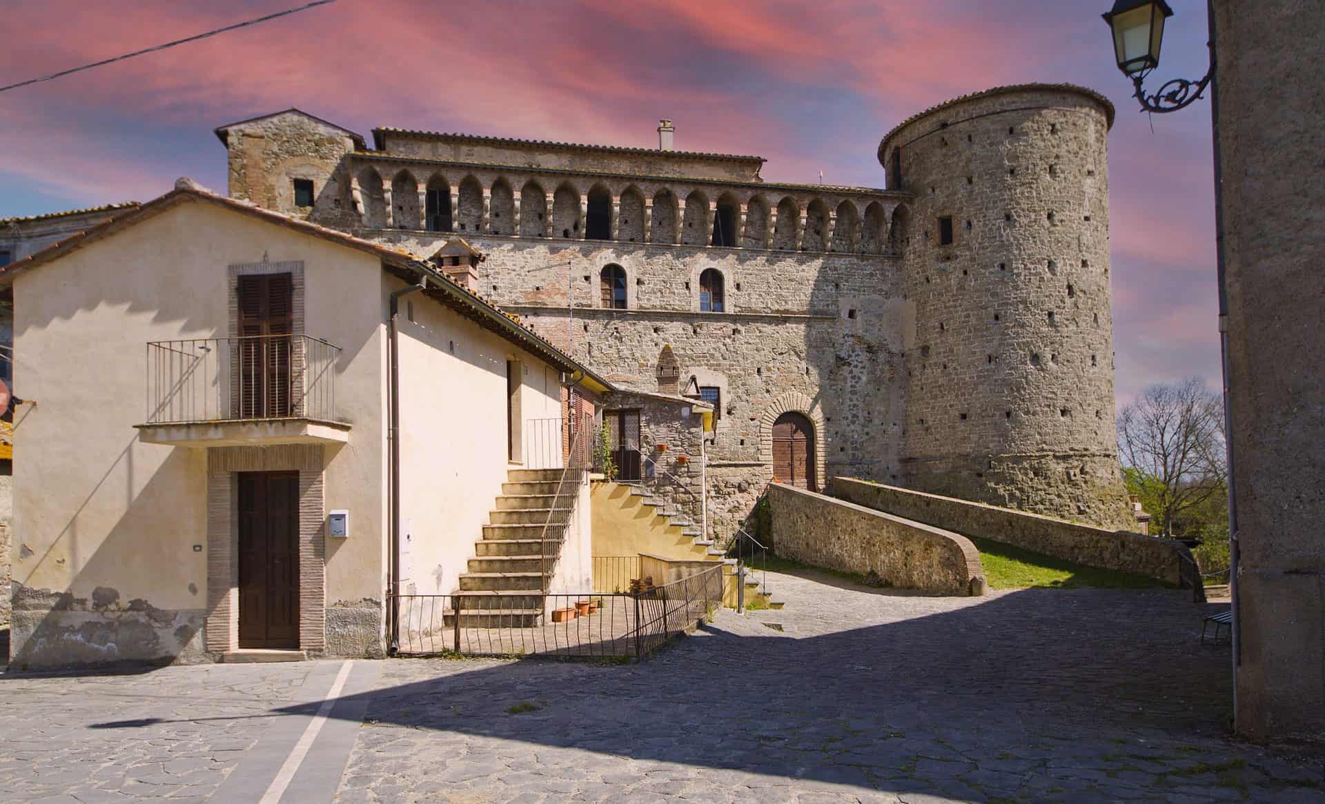
The Baglioni Castle of Graffignano, place by place
The Baglioni Castle, which the sources also call Baglioni Santacroce, is the most solid testimony of the medieval phase. Its quadrangular plan with corner towers is a model found throughout central Italy and answers a precise military logic: cover every side with fire, eliminate blind spots, offer a compact structure that can be defended even by a garrison of limited numbers. It's not a frontier stronghold designed to withstand a siege by regular armies, it's a building for territorial control, the medieval equivalent of an area command protecting the supply routes between Viterbo and Umbria. Anyone looking at it from the outside immediately notices the disproportion between the mass of the structure and the size of the town: it's a clue, and it tells us that the strategic importance of the site was greater than its demographic weight. It's the most legible castle in the Teverina, because it was neither ruined by abandonment nor disguised as a villa, and for that reason it's worth more than a glance from the car window.
The exterior: the two towers, the battlements and the scarp
The first thing you see is the facade facing the square, with the large cylindrical tower on the right, 23 meters high, which was originally even taller and contains a spiral staircase. On the opposite side a second round tower, lower, added between the 16th and 17th centuries when the structure was adapted to firearms. Along the whole perimeter runs a projecting battlement on corbels, and at the base the masonry widens into a scarp, the slope typical of post-artillery military architecture that served to deflect shots and prevent ladders from being set against the wall. In front of the entrance the moat, dry today, is crossed on a masonry bridge. Walking around the building you can read all the layers: the 14th century of Simonetto Baglioni in the towers and merlons, the 16th century in the scarp and the second tower, the 18th century of the Santacroce in the regular windows of the residential wing.
The corridor, the garden and the lemon house
Once through the entrance, a central corridor crosses the building and leads to the garden at the back and to the lemon house, the winter shelter for potted citrus trees that every noble residence in central Italy had. It's here that you understand the castle's second life. Medieval fortifications, during the Renaissance, underwent a process of reconversion everywhere: they gradually lost their military function, made obsolete by artillery, and acquired a residential and representational one. Windows that open where there used to be arrow slits, courtyards that become reception spaces, rooms that get decorated. In the fortress of Graffignano this double soul is readable, and it's perhaps the most interesting thing to observe: you see the moment when a war machine begins to become a home.
The double staircase and the vaulted rooms
From the corridor you go up a double-ramp staircase that separates the noble rooms from the rest of the structure. On the ground floor and along the route there are vaulted rooms with carved stone elements: jambs, brackets, keystones with the coats of arms of the families that have succeeded one another. They are bare rooms, and should be read as such: this is where the foodstuffs were kept, the garrison was lodged, the justice of the fief was administered.
The piano nobile and the Salone
On the piano nobile you arrive in a large hall of more than 70 square meters, from which you enter the other rooms, following the scheme of the lordly residence: the salon as the pivot, the private rooms all around. The Salone Nobiliare was recently restored by the Municipality and is hosting events, exhibitions and ceremonies again: during the Sagra della Lumaca the castle opens its doors to everyone. The 18th-century wing, with its more domestic proportions, tells the story of the Santacroce phase, when the fief was by then a farming business with a Roman prince as an absentee owner.
The Logge and the 2009 excavations
The Logge, today a separate building in the village, were an old appurtenance of the castle: the name says it all about its function as a portico and open storehouse. In 2009, during restoration work, workers discovered three waste pits dated between the 15th and 16th centuries, full of ceramics, animal bones and household refuse: for scholars a precious source, because the garbage of a Renaissance court tells everyday life better than any notarial document. Local tradition adds, as in every castle worth the name, the ghost of a lady who is said to wander the corridors: I report it as folklore, with no claim to being a chronicle.
How to visit the Baglioni Castle
Since 2000 the castle has belonged to the Municipality, which looks after its conservation and opens it with the help of civil service volunteers. It's not open daily: you book in advance by calling 0761 901001 (extension 1) or writing to civileservizio028@gmail.com, and visits are generally concentrated on weekends. The regional tourism agency lists them as free. It's best to ask for confirmation. The castle's social media pages announce special openings and events. My advice is to book at least a week ahead and not to show up hoping it's open: it's the most reliable way to stay outside.
The churches of Graffignano (VT), one by one
The churches of the main town are three in the center and two in the countryside, and none is a masterpiece: I say so right away to calibrate expectations. They are churches of a farming community, built and rebuilt with the means of a farming community, and they should be read as such. But inside they preserve objects that tell the history of the fief precisely, starting with the devotion imported by Domitilla Cesi.
The church of San Martino Vescovo, the parish church
Saint Martin is the patron saint, celebrated on November 11, when the new oil has just arrived from the mills. The parish church dedicated to him holds a copy of Guido Reni's Saint Philip Neri (the original is in Rome, in the Chiesa Nuova), an 18th-century wooden bust, a canvas of Saint Charles Borromeo, a reliquary of the Holy Cross and the confraternity's crucifix. Look at the whole with a historian's eye: Philip Neri is the saint brought by Domitilla Cesi, Charles Borromeo is the family saint of the Borromeo who followed, Santa Croce is the name of the house that closed the series. The three lordly families of the fief are all on the altar.
The church of San Sebastiano
San Sebastiano has a very simple structure, with a plastered facade embellished only by a doorway framed in stone. The dedication tells its function: Sebastian, with Roch, is the saint invoked against the plague, and churches named after him normally stand at the edges of the settlement, where contagion was stopped. You'll find the same pairing of Sebastian and Roch in the fresco at the Castellonchio.
The Madonna delle Vigne and the Sanctuary of San Leonardo
In the San Francesco locality stands the church of the Madonna delle Vigne, built by countryside workers as thanks for the harvests: a peasant votive church, with a name that indicates the crop that paid for it. The Sanctuary of San Leonardo, in the countryside, is the municipality's other rural church. Published information on both is scarce, and they should be considered destinations for those with time, to ask about in town, not obligatory stops.
The Casone Santa Croce
The Casone Santa Croce is the large rural building tied to the Santacroce princes, who from 1741 ran the fief as a farming estate. It's not a church and not a castle: it's the testimony of the economy that kept Graffignano going until the 20th century, the great landed property with its sharecroppers. You look at it from the outside.

The Sanctuary of the Madonna del Castellonchio
A couple of kilometers from the town, in the Selve locality, among age-old pines, stands the sanctuary that the people of Graffignano feel is most their own. The story is a model of how devotion worked in this border land. On the spot there was a castle, the Castellonchio precisely, destroyed by the people of Orvieto in 1316 during the wars with Viterbo. On its ruins, in the second half of the 15th century, a chapel was built with a fresco of the Virgin opening her cloak to protect the kneeling common people, flanked by Saint Sebastian and Saint Roch: the iconography of the Madonna della Misericordia, by an unknown hand, which here took the title of Salus Infirmorum, health of the sick. The pairing of the two anti-plague saints and a tradition never contradicted indicate that the place served as a lazaretto, a shelter for plague victims outside the town.
The devotion grew over the centuries, to the point that in 1908 the 15th-century building was no longer enough for the pilgrims: the present sanctuary was built, inaugurated on September 8, 1910, the feast of the Nativity of Mary. The rose window of the facade, in 212 pieces, is the work of the Roman artist Laura Belforti and dates to 1990. Inside are the ex votos, the miraculous fresco and a canvas of the Umbrian school with the Madonna between Saints Sebastian and Roch. The church is entrusted to the Confraternity of the Madonna del Castellonchio, and the archive of the curia of Bagnoregio keeps its papers from 1848 to 1906. The right moment to go is September 8, when the community goes up to the sanctuary. On other days it's best to ask at the parish about opening. As architecture the 1910 sanctuary is modest, but the place, with the pines and the silence and the memory of a castle destroyed seven centuries ago, is among the most intense in the municipality. Go at sunset.
A curiosity about Graffignano (VT)
Every town has its postcard curiosity, the one that ends up on information panels and in brochures. Graffignano has several, but none is the kind you can sum up in a sentence. They are curiosities that need a bit of context, and once understood they change the way you look at the whole territory.
A municipality with two castles, and neither is what you expect
The first thing that throws off anyone arriving is that the municipal territory of Graffignano contains two distinct fortifications: the stronghold of the main town, tied to the name of the Baglioni, and the baronial palace of Sipicciano, which old records call Rocca dei Pirri, from the name of the Pirro Baglioni who lived in it. It's not a convenient duplication: they are two buildings born of different needs, at different times, and for long stretches of history they answered to different lords, though often of the same family. Between 1644 and 1879 Sipicciano belonged to the Costaguti, who bought it for 90,000 scudi, while Graffignano passed from the Borromeo to the Santacroce.
This double presence is a sign of something that hit-and-run tourism never grasps: in the medieval Tuscia the geography of power was extremely fragmented. There were no compact territorial states, there were networks of castles, each with its own jurisdiction, its own farmland, its own community. A castle controlled a radius of a few kilometers, enough for the garrison to intervene within the day. The result was a density of fortifications that today seems absurd and that was in fact normal: in an area you cross in 20 minutes by car, four or five autonomous garrisons coexisted, and one of them, the Castellonchio, did not survive 1316.
The stronghold of Graffignano has the classic form of the quadrangular castle with towers at the corners, a type that historians of military architecture call regular plan and that represents an evolution from fortifications that grew by aggregation around an original tower. The regular castle is designed, not layered: someone thought it out in advance, with criteria of symmetry and defensive coverage, and that someone was Simonetto Baglioni in the 14th century. The palace of Sipicciano, instead, has the look of the manor that grew together with the village, with the fabric of the houses leaning on the walls and forming an integral part of them. Walking in Sipicciano means not always understanding where the fortification ends and the settlement begins, because the two systems have interpenetrated over the centuries.
There's an aspect I find fascinating. In medieval logic, having two castles within a radius of a few kilometers did not mean double security: it meant potential conflict. Two nearby garrisons belonging to different lords were a permanent source of friction, over farm boundaries, water rights, tolls, pasture. The Litigata of 1546 is the documented case at Graffignano, and the archive records of the Tuscia are full of disputes of this kind.
The candles in snail shells
The second curiosity is tiny and I find it the most beautiful. The farmers of Graffignano, on summer festival evenings, put little lights in their windows made from snail shells: the shell set on a layer of ash to hold it steady, a thread of olive oil inside, a wick. A poor devotion, with what they had at home, in a town where olive oil was never lacking and neither were snails. From this custom was born the mid-August Sagra della Lumaca and its most photographed evening, A Lume di Lumaca, when the castle and the alleys of the Di Dentro light up with thousands of these little lights. It's the moment when Graffignano presents itself to the world for what it is: a town that made an identity out of a farmer's necessity.
A position worth more than it seems
The last curiosity is the most useful in practical terms, and it concerns geographic location. Looking at a map, Graffignano appears to be a marginal point, far from the main routes. In reality it's the opposite: the town sits at the center of a triangle whose vertices are some of the most visited destinations in northern Lazio. To the northwest is the Bagnoregio system and Lake Bolsena. To the south is the Bomarzo area with its Parco dei Mostri, one of the most extraordinary Mannerist gardens in Europe. To the west is Viterbo with the medieval San Pellegrino quarter and the hot springs. To the east, once you cross the Tiber, you enter Umbria and in a short time reach Orvieto. In the middle, a constellation of villages that each deserve their own half day: Bassano in Teverina, Orte, Vitorchiano, Celleno with its ghost village.
Anyone who chooses Graffignano as a logistical base gets two advantages. The first is economic: lodging in the smaller villages systematically costs less than in the top destinations, for the same quality. The second is one of rhythm: you sleep in a quiet place, you head out early in the morning and reach the crowded destinations before the groups, and you come back in the evening to a town where at nine o'clock you can hear the silence. For anyone who wants a tailor-made itinerary that alternates famous destinations and minor stops, the TourLeaderPro group trip organization service works with exactly this logic.

Sipicciano, the town within the town of Graffignano
Sipicciano is the only hamlet of Graffignano, with about a thousand inhabitants, and has a longer history than the main town. It stands on a plateau a kilometer and a half from the Tiber, divided into two districts, San Nicola and Poggio del Castagno, separated by a deep ditch, along the Sipiccianese provincial road. This duality is typical of the municipalities of the Tuscia, where modern administrative boundaries have often united under one municipality places that for centuries had glared at each other. The result is that a municipality of 2,000 inhabitants contains two distinct historical identities, two slightly different ways of speaking, two calendars of festivals that don't overlap. For the attentive visitor it's a richness: a trip to Graffignano is not the visit to a town, but to a small system.
A thousand years of autonomy: from Farfa to 1928
The first mention is from 840, when Emperor Lothair I confirmed to the abbey of Farfa its privileges over the fundus Sepicianus: the great Sabine monastery owned lands throughout the Tiber valley. Around the year 1000 part of the settlement belonged to the church of San Marcellino. In the 12th century Sipicciano obtained communal autonomy, with its own statutes, ordinances and seal. The choice of the Ghibelline side, alongside Viterbo, proved costly: on June 10, 1293 the Guelph troops of Orvieto assaulted and destroyed the castle. In the 14th century Cardinal Albornoz, with the support of Simonetto Baglioni, brought the town back under the Church, and from then on it was granted as a reward or tribute to different lords: the Baglioni held the castle from the middle of the 15th century to 1633, then came the Altemps, the Barberini and, from 1644 to 1879, the Costaguti. In 1872 the hamlet lost its autonomy of a thousand years with the merger into Roccalvecce. From 1887 it repeatedly asked to pass to Graffignano, and obtained it in 1928. The referendums to become a municipality again, in 1967 and in 1976, did not go through.
The Baronial Palace, the Rocca dei Pirri
The 15th-century baronial palace dominates the historic center and was the residence of the Baglioni, then of the Altemps, the Barberini and the Costaguti. The medieval part, the Rocca dei Pirri, was transformed into a residence in the second half of the 16th century by Alberto Baglioni, count of Castel di Piero and Sipicciano, husband of Diana Monaldeschi, and it was here that on May 7, 1575 the marriage contract of his son Federico was signed. The village houses leaned against the palace walls, the gates became urban passages, the walkways turned into alleys. The palace is privately owned and can be visited only during Pro Loco events, such as the reenactment of the Baglioni wedding with the Renaissance banquet.
Santa Maria Assunta in Cielo
The church of Santa Maria Assunta in Cielo, cited by documents from the early 14th century, has a simple facade with a Renaissance portal, a Gothic rose window and a bell gable. The interior has a single nave with a wooden-truss ceiling, side altars, a baptismal font from the late 15th century and the niche of the Holy Oils. Reduced to a ruin in the 20th century, it was recovered at the end of the 1960s on the initiative of the local clergy. The Municipality consolidated it about 20 years ago, and the Ministry of Culture has funded two new interventions for securing and restoration, presented to the community in April 2023 by the Soprintendenza together with the Pro Loco. Many furnishings were moved to the new parish church.
The Baglioni Chapel and the frescoes of Marzio Ganassini
The Baglioni Chapel is the artistic heart of the whole municipality, and I say it without hesitation: it's the only strictly artistic reason an art historian should detour out here, and it's a sufficient one. Alberto Baglioni wanted it as the family funerary chapel starting in 1581 (some studies move the start back to 1577), and his sons Federico and Pirro II completed it between 1591 and 1601, entrusting the work to the architect Troiano Schiratti of Soriano. The altarpiece, Saint Francis Receiving the Stigmata, is signed by Durante Alberti of Borgo Sansepolcro and dated 1601: a painter who in Rome worked for the Oratorians and for Sixtus V. The fresco cycle is attributed, with the most convincing support from recent criticism, to Marzio Ganassini, a Roman painter and pupil of the Cavalier d'Arpino, who is said to have portrayed himself in one of the scenes. On the vault, five panels with the miracles of Saint Francis: the healing of a dropsical child, sight restored to a woman, the healing of a cripple, Saint Francis with the Virgin and Child, the healing of a woman with crippled hands. On the walls, on the right the saint healing a leper, on the left the miracle of the resurrection. It's late Roman Mannerism transplanted into a farmers' town, with that nervous drawing and those acid colors that the Cavalier d'Arpino taught his followers. The chapel was restored in the 1980s by the Soprintendenza and can be visited by reservation through the Pro Loco of Sipicciano (proloco.sipicciano.vt@gmail.com) or the Municipality's civil service.
San Bernardino, San Vincenzo and Villa Lais
The church of San Bernardino is an isolated building in blocks of tuff, peperino and limestone, with a rose window, a single nave and a wooden ceiling: the church of the Franciscan observance, as simple as the saint from Siena wanted. On the edge of town the chapel of San Vincenzo leans against Villa Lais, an 18th-century estate surrounded by age-old trees, which the Pro Loco opens now and then for visits and meetings. In the hamlet there is also a small museum of peasant civilization, open during events. Sipicciano looks out close to the Lake Alviano Oasis and the Monte Casoli reserve: if you like birdwatching, you have the Tiber a quarter of an hour away on foot.
Something nobody tells you about Graffignano (VT)
We come to the most useful part, the one that saves time for those who know it beforehand. These are the things you don't find in the official descriptions, not because they're secret, but because nobody has an interest in putting them in writing: observations that come from going back several times, from talking to people, from making mistakes. Some are uncomfortable.
Graffignano lives by rhythms that aren't yours, and that changes everything
The first thing nobody says is that Graffignano doesn't run on the tourism calendar. It has no high season and low season, no hours designed for visitors, no organization that switches on when you arrive. It runs on the agricultural calendar and on the habits of a resident community, and anyone who doesn't understand this runs into a series of small, avoidable frustrations.
Concretely: in the early afternoon, between 13:00 and 16:00, the town stops. It's not a formal pause with a sign, it's simply the time when people eat lunch and rest. Bars may stay open with reduced staff, grocery stores close, the streets empty. Arriving at two hoping to find lunch and information means arriving at the worst possible moment. In the same way, the olive harvest, which here runs from November to January, changes people's availability: those with olive groves are busy from dawn to dusk and the mills run around the clock. It's the most fascinating time to understand the territory but also the one when it's hardest to get anyone's attention. The corollary is that Sunday isn't necessarily the best day: in tourist towns everything works on Sunday, here it's often the day when many businesses rest. A Saturday morning, or a Friday, offers a richer experience, because the town is in its normal working mode.
Being close to Civita is a resource and a curse
The second thing nobody says concerns the complicated relationship between this territory and its famous neighbor. Civita di Bagnoregio is a few kilometers away and attracts over half a million visitors every year, a number orders of magnitude higher than that of all the surrounding villages put together. The positive effect is obvious: those who come for Civita are already in the area, and convincing them to move a quarter of an hour away is relatively easy. In recent years a small proximity economy has developed, made of farm stays, lodging and agricultural products that intercept traffic headed elsewhere. The negative effect is subtler and concerns the imagination. Civita has built a narrative so strong, the dying town, the suspended bridge, the tuff island, that everything around it is perceived as a lesser version of the same thing. The visitor who has just crossed the bridge arrives in Graffignano with a yardstick that crushes anything else.
The counterintuitive suggestion is to visit Graffignano before Civita, not after. In that order you arrive with eyes not yet saturated, you appreciate the town for what it is, and then Civita becomes the culmination of a progression. In the reverse order, everything that comes after the bridge looks like a fallback. There is also the question of the sustainability of the Civita model: a village of minimal size with 12 permanent residents and hundreds of thousands of visitors lives under permanent stress, with lines, prices aligned to demand and a heavily mediated experience. The nearby villages offer, to those who accept giving up the icon, the same kind of landscape and the same architecture in conditions of quiet. It's a trade: you lose the masterpiece, you gain the silence. If you read English, you'll find the comparison between the two ways of visiting in ItalyPlanner's guide to Civita di Bagnoregio.
The scenic roads are the real attraction, and they aren't signposted
The third thing nobody says is that the best part of a day around here takes place in a car, or on a bicycle, on the provincial roads that connect one town to the next. This is not a joke: the minor road system of the Teverina crosses a landscape of exceptional quality, with views over the Tiber valley, stretches through olive groves, descents into wooded ditches and climbs that open sudden panoramas over the badlands. The problem is that nobody signposts it. There are no scenic routes with signs, no equipped lookouts, no pullouts designed for photography. The visitor who follows the navigation system crosses this beauty without noticing.
The countermeasure is simple: allow double the time for every transfer and consider the road part of the visit, not an interval between two visits. The routes I recommend driving slowly are the one toward Castiglione in Teverina, which crosses the wine-growing area and offers views over the valley, and the one toward Civitella d'Agliano, which is the best route for the badlands. Heading south, the road toward Bassano in Teverina crosses an agricultural landscape of great balance. A note for those on a bicycle: these roads are excellent for cycle touring but the elevation gain adds up, and water refill points are scarce.
Not everything can be visited, and that's fine
The fourth thing nobody says is perhaps the most important for calibrating expectations. In Italy we're used to thinking that historic heritage is by definition accessible: if there's a castle, you visit it. If there's a church, you go in. In the smaller villages this isn't true, and not out of ill will. The baronial palace of Sipicciano is private. The Baglioni Castle is public but opens with volunteers, so not every day. Santa Maria Assunta is under restoration and the Baglioni Chapel opens to those who ask in time. This produces a patchwork situation, and the practical consequence is that you have to find out case by case and in advance, by contacting the Municipality or the Pro Loco. Showing up hoping it's open is a reliable way to stay outside.
But there's a positive flip side. In these towns there are volunteers and enthusiasts who open up, accompany and tell the story free or almost free, out of pure passion for their territory: at Graffignano the young people of the civil service, at Sipicciano the Pro Loco, which has serious historical research behind it, with scholars who have published on the Baglioni Chapel. Meeting one is worth more than 10 standard guided visits.
Slow tourism here isn't a slogan, it's the only possible way
The last thing nobody says concerns the very way of conceiving travel in this part of Italy. The expression slow tourism has become a marketing label used everywhere, often with no content. In places like Graffignano it literally describes the only practicable way. There's nothing to consume quickly, no monument you see in 10 minutes and tick off the list. If you arrive with the logic of efficiency, this place will seem empty. If you arrive willing to stop, it will fill you. This means putting fewer stops in the program, accepting that a day holds two places instead of five, leaving empty spaces because the best things happen in the unplanned moments: the conversation with the owner of the olive mill, the detour onto a dirt road, the hour spent on a low wall watching the valley change color. It also means spending money differently: a bottle of oil bought from the person who makes it, wine bought at the winery, cheeses and preserves. It's money that stays in the territory and that you take home in a form that lasts longer than a memory.
The advice I give you for visiting Graffignano (VT)
In a single sentence: don't come to Graffignano for Graffignano. It seems like a contradiction on a page that devotes thousands of words to it, but it's the most honest advice I can give. This town is not a self-sufficient destination, it's a piece of a system, and anyone who arrives expecting the complete experience of a monument-village will be disappointed. Anyone who instead puts it in the right place in a wider itinerary will discover that it is precisely the stop that makes everything else coherent. The tourist circuits of the Tuscia work by isolated points: you go to Civita, you photograph the bridge, you go back. You go to Bomarzo, you walk the garden, you leave. Every destination is a fenced attraction, and between one and the next there's a transfer experienced as lost time. The result is that you visit the Tuscia without ever seeing it, because the Tuscia isn't in the individual monuments but in the territory that connects them. Graffignano is that territory.
Building the day with Graffignano in the middle
The first operational piece of advice is to put Graffignano in the middle of the day, not at the ends. Early morning at a big-draw destination, when it's still empty. Midday here, unhurried, lunch included. Afternoon at a second destination, or on a scenic drive along the badlands roads. It's a structure that alternates intensity and decompression, and that places the slow part at the moment when the crowding elsewhere is at its peak. The second piece of advice concerns the pace of your steps: here there's no obligatory route and no arrow to follow. You park, you choose a direction, you go. You take a wrong street, you turn back, you come out in a wide spot you didn't know existed. In a big city it would be inefficient, in a town of this size it's the only method that works.
Give Sipicciano real time and book the castle
The third piece of advice is not to treat Sipicciano as an appendix. I often see people who arrive, tour the main town and leave thinking they've seen the municipality: it's like visiting a house by entering only the kitchen. Allow at least an hour, better two, and book the Baglioni Chapel a week ahead, because it's the artistically most important thing in the whole municipality. The fourth piece of advice is about expectations for the interiors: book the castle in good time and, if that isn't possible, remember that the value of these buildings, for the visitor, lies overwhelmingly in the exterior, in the mass, the position, the relationship with the village and the landscape.
The right hour and the right person
The fifth piece of advice is about timing. This is an area where light makes an enormous difference, much more than in the art cities. Tuff and clay have colors that turn flat at noon and turn gold at seven in the evening. The badlands, in particular, are almost invisible with the sun high because the shadows that define their relief are missing, and they become spectacular in the two hours before sunset. If you have only one chance, spend it in the late afternoon. The sixth piece of advice is to talk to someone. It sounds like a cliché, but here it has a practical meaning: in a town without tourist infrastructure, information circulates by word of mouth. The bartender, the man on the bench, the woman watering her flowerpots are the information service of this place. All it takes is a question asked politely, where you can see the castle best, where the road to the badlands is, where to eat well, and in most cases you get an answer that comes with a story.
Lunch, children, driving and good manners
The seventh piece of advice is to bring lunch or book. Dining in small villages works on low, planned volumes: a restaurant that on a Wednesday at noon in November gets four people with no warning may simply not have the supplies to serve them. A phone call the day before solves the problem. Alternatively, a sandwich with new oil bought at a grocery store and eaten on a low wall with a view of the valley has nothing to envy a restaurant. The eighth piece of advice is for those traveling with children: Graffignano works very well with kids, as long as you set up the day as exploration. A real castle with a 23-meter tower, alleys to get lost in, badlands that look like a Martian landscape, and the combination with the Monster Park of Bomarzo, which for children is a 16th-century playground. The ninth piece of advice is about driving: the provincial roads of the inland Tuscia are narrow, winding and often without guardrails. Blind curves, farm vehicles, animals, in autumn wet leaves. Always add a margin to the navigation system's times, and don't drive while looking at the scenery: pull over, get out, look, set off again.
The tenth piece of advice is the most important and concerns attitude. Graffignano is not a prepackaged tourist product. It's a town where people live, work, have their problems and their habits. The visitor is a guest in a community, not a customer at an attraction. This means concrete things: don't photograph people without asking, don't park in front of driveways, don't raise your voice in the alleys during siesta hours, don't enter private courtyards even if the gate is open. It seems obvious, and yet it's the difference that determines whether the next town will find people willing to talk to you or people who shut themselves in their houses. If I had to design the perfect itinerary I would structure it over two days: the first on the north side, Civita di Bagnoregio early in the morning, Graffignano for lunch and the afternoon, sunset over the badlands. The second on the south and east side, Bomarzo, Bassano in Teverina and a finish at Orte with its underground city. Anyone who prefers to hand the direction to a professional will find in TourLeaderPro someone who builds private and corporate tours with this logic.
Another well-known fact, yet rarely cited
That the Cesi family passed through Graffignano everyone in town knows: the feast of the Addolorata and the cult of Saint Philip Neri come from there. What is rarely cited is the weight of that surname in the history of science. Federico Cesi, born in Rome in 1585 into the family of the dukes of Acquasparta, founded the Accademia dei Lincei in 1603, at the age of 18, the first scientific academy in Europe, and in 1611 welcomed Galileo Galilei into it, who published The Assayer under the Lincei's banner. Domitilla Cesi, the countess who inherited Graffignano at the beginning of the 17th century, belonged to that same house. At the very time when in Rome the Cesi were funding the first microscope and the observations of sunspots, one branch of the family was administering a farmers' fief on the Tiber valley and bringing there the relics of a saint. The two things are not in contradiction: in the Rome of the early 17th century Counter-Reformation devotion and the new science lived in the same palaces, and Philip Neri, who died in 1595, had been the confessor of half the Roman aristocracy, the Cesi included. Looking at the copy of Guido Reni's Saint Philip in the parish church of San Martino, think about this: it's the trace left in Graffignano by a family that was changing the way of looking at the sky.
The second well-known and rarely cited fact concerns the river. Everyone knows Graffignano overlooks the Tiber. Few remember that until well into the 19th century the Tiber was navigable and that the Teverina lived off this. Timber, charcoal, grain, oil and building materials went down toward Rome. Goods came back up on the return, towed along the towpaths. There was a specific trade, that of the boatmen, with its techniques, its slang and its families. The Rome-Florence railway, which still runs today on the other bank with the Attigliano-Bomarzo stop, and then the modern roads swept away that world in a few decades, leaving almost nothing visible. For centuries the identity of this valley was riverine before it was road-based, and the Baglioni castle watched over a river that was a road.
The abandoned villages and badlands around Graffignano
In the immediate surroundings of Graffignano there are settlements that have been progressively emptied and in some cases abandoned altogether. It's a phenomenon that in the Tuscia has an impressive density and different reasons depending on the case: ground instability, landslides, epidemics, the shifting of communication routes, simple demographic exhaustion. The Castellonchio, wiped out in 1316 by an army, is the oldest case in the municipality. The most famous in the area is of course Civita di Bagnoregio, which turned its condition as a dying town into a formidable tourist engine. The most instructive is Celleno, the ghost village a quarter of an hour away by road, abandoned in the 20th century because of landslides and visitable today. But Civita is the exception that got lucky: within a radius of 20 kilometers there are other settlements in the same geological conditions, with the same fate of erosion, that nobody visits and that don't even have a sign.
I find this asymmetry one of the most instructive things you can observe in this province. It's not that Civita was more beautiful or more important than the others: it's that at a certain point someone knew how to tell its story, and the story created the value. The other emptied villages are still waiting for their narrator, and in the meantime erosion keeps working without hurry. Walking around Graffignano with this outlook changes the experience. You begin to notice, along the provincial roads, the dry-stone walls that bound fields no longer cultivated. You see the ruins of farmhouses with the roof collapsed and a fig tree growing inside the room. You sense, on the ridges, the regular cuts that betray ancient human labor. It's a diffuse archaeology, unprotected, unsignposted, and for exactly that reason thrilling to recognize.
It has to be said clearly: approaching structures in a state of abandonment carries concrete risks. Unstable walls, collapsed floors, yielding ground especially near the badlands. It's better to observe and photograph from a distance, without entering dilapidated buildings and without venturing onto clay slopes, which after rain become treacherously slippery. Curiosity is legitimate, recklessness isn't.

The right photo to take in Graffignano (VT)
Then comes the most fun part, because photographing in this area is an exercise in patience and in reading light that pays off out of proportion to the effort. There are no obligatory framings, no pullout with a sign saying where to stand. You have to look for the photos, and this is precisely the reason it's worth it.
The castle from below, with the village rising around it
The main photograph, the one that sums up the town in a single image, is the castle seen from below, with the Di Dentro rising around it. You have to look for it by driving the roads that approach the town from the valley: the idea is to find the point where the quadrangular mass of the stronghold and the cylindrical tower stand out from the profile of the houses and read as an autonomous volume against the sky. It's a framing that works for a precise reason: it shows the hierarchy. The castle dominates, the town arranges itself, the countryside surrounds. In a single frame there's the whole logic of medieval incastellamento. The right time is late afternoon, when the low sun lights the masonry from the side and brings out its texture: the tuff takes on a color that runs from ochre to honey and that no digital correction can replicate starting from a photo taken at noon. If the sky has a few clouds, all the better. And if you happen to be there on the nights of the sagra, with the little lights in snail shells lit along the battlements, you have the night photo that no other town in Lazio can offer.
The badlands, with something to give the scale
The second photo is the one of the badlands, and it's the most technical. The problem with the badlands is that they're a subject without scale: if you photograph them in isolation, whoever looks at the image can't tell whether they're three meters high or 50. The solution is to include a size reference, a tree, a house, a road, a human figure. The second difficulty is light: with the sun high the badlands flatten and lose their relief. You need long shadows, so early morning or the last hour of the afternoon. The composition that works best puts the badlands in the foreground, the Tiber valley floor in the middle ground, the Umbrian hills in the background: a layering of planes that conveys the depth of the landscape. On days with light haze the effect is even stronger, because aerial perspective naturally separates the planes in different shades of blue.
The alleys of Sipicciano and the farm landscape
The third photo is the one of the alleys of Sipicciano, the most intimate. Here it's not about landscape but urban detail: look for covered passages, arches, exterior stairs, the spots where light enters through a crack and cuts the dark. These are images that work in black and white as much as in color, because the real subject is the contrast between light and shadow. A mistake I often see is looking for a clean framing, with no disturbing elements. In living villages it's impossible and not even desirable: a clothesline with laundry under a medieval arch doesn't ruin the photo, it makes it true. There is also a fourth category of images not to neglect: the farm landscape. The terraced olive groves, the rows of vines, the plowed fields that draw curves on the slopes, the piles of prunings burning on winter days, sending up threads of smoke. They're less spectacular than a castle but they tell the real economy of the territory, and over time they're often the ones you look at with the most pleasure.
Lenses, drones and changing weather
On the technical side: a moderate wide-angle is good for landscape and for narrow alleys. A telephoto lens, even a modest one, is more useful than you'd think, because it compresses the planes and isolates portions of a calanco or distant architectural details. A polarizer helps with skies but should be used with measure, because with a wide-angle it produces uneven skies. With a smartphone, a moderate optical zoom is better than an extreme wide-angle that distorts the architecture. A word on the drone, because the question always comes up: the badlands from above are spectacular, but the use of remotely piloted aircraft is regulated by precise rules on registration, competencies, flight zones and distances from people. Check the updated regulatory situation and, in any case, avoid flying a drone over the houses in a town where everybody knows everybody. Finally, the weather: the best days for photographing here are not the full-sun ones but those when the weather is changing. After a summer thunderstorm, when the air is washed clean. On an autumn morning with fog filling the valley and letting the hills emerge like islands. At a winter sunset with the sky going from orange to violet in 20 minutes. And the final advice: shoot little and look a lot. Walk for 20 minutes without taking anything out of your pocket, let your eyes get used to the colors and proportions, and only then begin. The images that come out are better, and what remains is the memory of having seen the place, not just of having recorded it.
Some important events that happened here in history
A town of 2,000 inhabitants doesn't have a textbook chronology, but the dates that follow are all documented by the local archives and by the Municipality's official chronology, and lined up they tell a border story more eventful than today's silence lets you imagine.
840: Lothair I and the abbey of Farfa
The Carolingian emperor Lothair I confirms to the abbey of Farfa its privileges over the fundus Sepicianus. It's the first time the name of Sipicciano appears in a document, and it says that in the 9th century the Teverina was already a land contested between the great monasteries and the lay powers.
June 10, 1293: Orvieto destroys the castle of Sipicciano
The Guelph troops of Orvieto assault Sipicciano, lined up with Ghibelline Viterbo, and destroy its castle. It's an episode in the wars between the two communes for control of the Tiber valley, which drag on through the whole 13th and 14th centuries.
1316: the end of the Castellonchio
Once again the people of Orvieto, at war with Viterbo, raze the Castellonchio, the castle two kilometers from Graffignano. On its ruins, a century and a half later, the sanctuary of the Madonna will be born.
Second half of the 13th century and the 14th century: the Baglioni and Viterbo
The Baglioni of Castel di Piero submit to the commune of Viterbo with the stronghold of Graffignano. In the 14th century Simonetto Baglioni rebuilds the castle almost entirely and supports Cardinal Albornoz in bringing the Teverina back under the Church. In the meantime Pandolfo dell'Anguillara, podestà of Viterbo, conquers the stronghold in one of the reversals of those wars.
1522-1531: two popes and a fief
Adrian VI, the Flemish pope with the very brief pontificate, confiscates the fief from the Baglioni to put an end to their feuds. In 1531 Clement VII, the Medici pope, returns it. In fewer than 10 years Graffignano passed from one pope to the other as a pledge in a family dispute.
1546: the Litigata
The border controversy with Civitella d'Agliano is closed: the contested strip of land is still called that today.
May 7, 1575 and spring 1576: the wedding of Federico Baglioni
Alberto Baglioni ratifies at Sipicciano the marriage contract of his son Federico with Curia Piccolomini Todeschini. The ceremony is celebrated the following year in Santa Maria Assunta. A few years later the same Alberto starts the Baglioni Chapel, which Federico and his brother Pirro II complete by 1601 with the altarpiece by Durante Alberti.
Early 17th century: Domitilla Cesi brings Saint Philip Neri
Countess Cesi inherits the fief, introduces the cult of Saint Philip Neri, brings his relics and establishes the feast of the Addolorata. In 1633 the Baglioni leave Sipicciano. In 1644 the Costaguti buy it for 90,000 scudi.
1741: Graffignano becomes a principality
The fief is raised to a principality and sold to Scipione Publicola di Santacroce, a Roman prince, who puts back in order a territory left in ruin.
1809 and 1870: Napoleon and Italy
The Napoleonic wars bring Graffignano into the Department of Rome and unite Sipicciano with the main town for the first time. In 1870 Lazio enters the Kingdom of Italy. In 1872 Sipicciano is merged into Roccalvecce and in 1928 into Graffignano.
June 1944: German troops in retreat
After the liberation of Rome, on June 4, 1944, German troops go up the Tiber valley and occupy Graffignano in the retreat north. It's the last passage of an army on these roads.
1910, 2000, 2009: the sanctuary, the public castle, the pits
On September 8, 1910 the new sanctuary of the Castellonchio is inaugurated. In 2000 the Municipality buys the Baglioni Castle from the private heirs, closing a century and a half that began with the emphyteusis granted by the Santacroce in 1886. In 2009, during restoration, the three waste pits from the 15th and 16th centuries come to light.
Who passed through Graffignano (VT)
The question of who passed through a place is always delicate when speaking of smaller villages, because the temptation to inflate is strong. I prefer to approach it differently: instead of listing illustrious names with fragile connections, I reconstruct who really crossed this territory and why. The result is less sparkling but much more instructive.
The Baglioni, lords and condottieri
Let's start with the Baglioni, who left the town their name tied to the stronghold and, at Sipicciano, the chapel. They are a family worth knowing because they perfectly represent a human and political type of Renaissance Italy: the house that builds its power on arms, that passes from mercenary military service to territorial lordship, and that lives in a permanent balance between alliances and vendettas. Their Perugian history is the stuff of Elizabethan tragedy, with the bloody wedding of 1500 in which half the family exterminated the other half. The Castel di Piero branch, that of Simonetto in the 14th century and of Alberto, Federico, Pirro and Ottaviano in the 16th, was less bloody but no less quarrelsome, to the point of having the fief confiscated by a pope. Knowing this changes the way you look at a stronghold in a quiet town of the Tuscia: those walls belonged to people for whom violence was an ordinary instrument of government. And Alberto's wife, Diana Monaldeschi, came from the family that at Bolsena and at Orvieto had done the same.
The Roman families: Cesi, Borromeo, Costaguti, Santacroce
After the Baglioni the fief became a bargaining chip among the great families of papal Rome, and each left something. Domitilla Cesi, the devotion to Saint Philip Neri and the link with the Lincei. The Borromeo, the family saint on the canvas in the parish church and a Cardinal Federico among the lords. The Costaguti, Genoese bankers turned Roman marquises, 90,000 scudi for Sipicciano in 1644 and more than two centuries of possession. The Altemps and the Barberini, passing through the baronial palace. The Santacroce, from 1741, the principality and the Casone. None of them lived here permanently: Graffignano was an income, administered by stewards. And yet what we see today, from the castle's 18th-century wing to the churches, is the result of their choices.
Condottieri, pilgrims and boatmen
Condottieri passed through this territory, for professional reasons. The strip between northern Lazio and Umbria was for two centuries a transit corridor for mercenary companies moving between the war theaters of central Italy, and who in the periods when they weren't hired lived off the land they crossed, that is, they plundered it. The fortifications we admire today as heritage were the rational response to a daily danger. Pilgrims passed through, perhaps the largest category: the route linking northern Europe to Rome crosses this part of Italy, and for centuries a continuous flow of people on foot walked these roads, between Via Francigena on the Viterbo side and Via Amerina and the Tiber valley on this one. Pilgrims who were not tourists: months of walking with minimal means, exposed to disease, bandits and bad weather, taken in by the hospitals of religious institutions. The lazaretto of the Castellonchio is a child of that world. Merchants and Tiber boatmen passed through, a presence rarely spoken of and one that was decisive for the economy of the valley until the 19th century.
Cardinals, Grand Tour travelers and filmmakers
Cardinal Egidio Albornoz, the Spaniard who in the 1350s and 1360s reconquered the Papal State castle by castle, passed through this Teverina with the support of Simonetto Baglioni. Between the 18th and 19th centuries, Grand Tour travelers passed through, though they rarely stopped in the smaller villages: the Tuscia was a land of transit for northern European intellectuals bound for Rome, and their diaries describe roads in terrible condition, spartan inns, landscapes viewed with a mix of romantic admiration and dismay at the backwardness. Postwar photographers and documentary makers passed through, who fixed the rural Italy that was disappearing. And filmmakers passed through: the Tuscia has been one of the favorite locations of Italian cinema, because it offers landscapes that can pass for any era while staying an hour from Rome and the production studios. The badlands, the tuff villages, the wooded ravines have appeared in dozens of films, often without the viewer having any idea where they were shot.
Farmers, emigrants and slow travelers
Then there are the passages that left no names but left everything else: the generations of farmers, sharecroppers, day laborers who built the dry-stone walls, terraced the slopes, planted the olive trees that are centuries old today, dug the cellars in the tuff, opened the roads, lit the little lights in snail shells. It's the anonymous population that physically made the landscape we come to photograph. And there are the emigrants, who passed through here going out: toward Rome in the boom years, toward the industrial north, abroad. Many closed houses in the alleys belong to families who live elsewhere and come back in summer or for the holidays, and who in recent years partly return, buying and renovating. Those passing through today, finally, are slow travelers: cycle tourists of the Tiber valley, walkers, food and wine lovers who come for the mills and wineries of the Strada del Vino della Teverina, photographers chasing the badlands. It's a tourism limited in numbers but interesting in quality, because it brings people who stop instead of passing through. The conclusion I draw from this list is that the history of Graffignano is not the history of those born here famous, but of those who passed through and of what they left in passing. It's a history of corridor, of border, of crossing. And in the end it's also the reason the town has such an unself-celebrating character: those who live in a place of passage learn that the world is bigger than their own bell tower.
Festivals and sagre in Graffignano: the snail, San Martino, the Addolorata
Every town of the Tuscia has its calendar of observances, religious, civic and tied to the products of the land, and on festival days the town is transformed: families who live elsewhere arrive, houses closed all year open up, collective lunches are organized. It's the best opportunity to see the community in its complete form, but it's also the moment when the outside visitor feels most clearly like one. It's worth going anyway, discreetly, without expecting to be at the center of attention.
The Sagra della Lumaca and A Lume di Lumaca
The festival that made Graffignano the city of snails is held in mid-August, for a week (in 2026 from the 11th to the 16th), organized by the association Open Graffignano-Sipicciano Tuscia, and has passed 25 editions. In the squares snails are served according to traditional recipes, stewed with tomato, garlic and mentuccia, accompanied by the wines of the Teverina and handmade pasta. There are orchestras, the snail race for children, and the castle stays open for visits. The evening A Lume di Lumaca, usually on the festival weekend, lights up the castle and the alleys with thousands of little lights in shells, following the farmers' custom described earlier. If you have to choose a single evening of the year to come to Graffignano, this is it. But arrive early, because parking, for once, becomes a problem.
San Martino, Saint Philip Neri and the Addolorata
On November 11 San Martino is celebrated, the patron saint who stands on the coat of arms, and the date coincides with the new oil: it's the best time to taste it at the mills. Saint Philip Neri, co-patron since the 17th century at the wish of Domitilla Cesi, is invoked to protect the harvests. The feast of the Addolorata goes back to the same countess. At the Castellonchio the community goes up on September 8, anniversary of the sanctuary's inauguration. At Sipicciano the Pro Loco organizes summer food festivals (the Festa del Bombolone e del Lombrichello, the local hand-rolled pasta) and, at no fixed interval, the reenactment of the Baglioni wedding of 1576, with a costumed procession to the church of Santa Maria Assunta and a Renaissance banquet in the baronial palace. Dates change every year: before planning your trip around a festival, check the channels of the Pro Loco and the Municipality.
Olive oil, wine and cuisine of the Teverina in Graffignano
Graffignano is in a border zone between Lazio and Umbria, and this position produces a cuisine and an agricultural production that don't respect administrative borders. The modern era had brought the territory into a long phase under the Papal State, with a conservative agricultural economy, landed property concentrated in the hands of the princes, a population tied to sharecropping and traditional crops. The olive and the vine were the two pillars, and still are.
Graffignano's olive oil and the mills from November to January
Extra virgin olive oil is the leading product, and the Municipality describes it, with justified pride, as among the most prized and least known, because production is essentially family-run. The olive groves cover the hill belts with favorable exposure, many plantings are generations old, and pressing takes place in the many local mills that work from November to January, often day and night. The oil of this strip of the Tuscia has recognizable characteristics: fruity of medium intensity, grassy notes, a bitterness that is present but not aggressive, a pungency you feel in your throat a few seconds after tasting. It's an oil for everyday use, not for collecting, and that is its strength. The harvest season is the most interesting moment to understand how this territory really works: families get organized, nets are spread under the trees, people work on the good days and take the olives to the mill quickly, because quality depends on the hours between harvest and pressing. Anyone who happens to be around here at that time witnesses a collective mobilization that is both work and social event.
The wine of the Strada della Teverina
Wine tells a parallel story. Graffignano is part of the Strada del Vino della Teverina, a border wine-growing area where white-grape and red-grape varieties coexist, with productions that in recent decades have seen a notable rise in quality. We're not in the territories of the big names, and for exactly that reason the ratio between quality and price is often interesting. The neighboring municipality of Castiglione in Teverina has the most deeply rooted winemaking tradition in the area, with a wine museum, and is worth a detour for anyone interested in the subject. On the other bank, Orvieto puts its white wine half an hour away by road.
Snails, lombrichelli and farm cooking
On the table, the cooking is the farm cooking of inland central Italy: legume soups, homemade pasta (lombrichelli, thick spaghetti of only water and flour rolled by hand, are the shape of the Teverina), white meats and lamb, seasonal vegetables, wild herbs gathered according to a calendar every family knows, and a use of oil that is not a dressing but a structural ingredient. Snails are the signature dish, stewed with tomato, garlic, chili pepper and mentuccia: a food of foraging, not of farming, eaten when meat was lacking. Anyone looking for sophisticated dining will have to head toward Viterbo or Orvieto. Anyone looking for honest cooking tied to the territory finds it here without having to chase it, as long as they book.
Graffignano (VT) with children and accessibility
With children Graffignano works, as long as you set up the day as exploration and not as a cultural visit. A real castle with a moat and a tower with a spiral staircase, alleys to get lost in, exterior stairs to climb, open fields, badlands that look like a Martian landscape, and in August a snail race: these are elements that capture the attention of little ones much more than a museum. The combination with the Monster Park of Bomarzo, half an hour away, makes a day that works for all ages. If you read English, you'll find the practical details in ItalyPlanner's guide to the Parco dei Mostri. A stroller in the Di Dentro suffers: a baby carrier is better.
On accessibility we have to be clear. The old village is on an outcrop, with stone paving, slopes and exterior stairs: if you use a wheelchair you can reach the square in front of the castle and the viewpoints along the main road, but not the innermost alleys. The castle has a double-ramp staircase to the piano nobile and no elevator. It's best to ask the Municipality, when booking, which rooms can be reached. The sanctuary of the Castellonchio, on level ground among the pines, is the easiest place in the municipality. Sipicciano has a difference in elevation between the two districts, but the church of Santa Maria Assunta and the baronial palace are in the upper part, reachable by car.
When to go to Graffignano and when to avoid it
On the seasons it's worth being precise. Spring is the best period by far: the countryside is green, the badlands have that color contrast between pale clay and vegetation that makes them photogenic, the temperatures let you walk all day, and in May you may find the Pro Loco's festivals. Autumn is the runner-up, with the not negligible advantage of the grape harvest and, from November, of the olive harvest, which here are not folklore for tourists but real economic activities you can observe while they happen. San Martino, on November 11, is the date to mark. Summer is livable but needs managing: the inland Tuscia in August is hot and the midday light flattens everything, so it's best to concentrate the visit in the early hours of the morning or in the late afternoon, and the week of the sagra is the exception that's worth the heat. Winter has a severe charm, with fog rising from the Tiber and filling the valley, letting only the tops of the hills emerge, and with the mills running. But you have to allow for short days, the north wind and reduced services.
One last note on services. Graffignano is a small municipality and its commercial offering is that of a farming town: grocery stores, bars, a few places to eat, a couple of businesses tied to local production, farm stays in the countryside. Don't expect the hospitality of a tourist resort, but not a desert either. The operational advice is to check in advance the hours of whatever interests you, especially off season, and not to count on everything being open on Sunday afternoon.
What to see around Graffignano within half an hour
The real value of Graffignano is its position, and this chapter is the proof. 10 minutes away is Civitella d'Agliano, the town of the Litigata, with the best badlands in the area along the road. A quarter of an hour away, Celleno, the ghost village abandoned because of landslides, and Castiglione in Teverina with its wine. 20 minutes away, Civita di Bagnoregio, with the bridge, the ticket and the crowd. Half an hour away, to the south, the Parco dei Mostri di Bomarzo and the reserve of Monte Casoli, with the Etruscan caves. Bassano in Teverina with the clock tower that encloses the bell tower. Vitorchiano with its outcrop and the moai. Also half an hour away, Orte, with the underground city, and Viterbo, with San Pellegrino and the Palazzo dei Papi. Across the river, in Umbria, the Lake Alviano Oasis for birdwatching and, 40 minutes away, Orvieto. To the northwest, Montefiascone and Lake Bolsena in three quarters of an hour. Within a half-hour drive of Graffignano there is, in essence, the best concentration of villages in Lazio, and this quiet town is the only place from which you can reach them all in a reasonable time while sleeping in silence.
Quick questions about Graffignano (VT)
Where is Graffignano and in which province?
Graffignano is in the province of Viterbo, in northern Lazio, in the Teverina area, on the side that looks over the Tiber valley and the border with Umbria. It sits at an elevation of 187 meters and has a little more than 2,000 inhabitants.
How far is Graffignano from Rome?
About 100 kilometers, an hour and a quarter by car on the A1 exiting at Orte or Attigliano. From Viterbo it's about 30 kilometers, a little more than half an hour.
Can you get to Graffignano by public transportation?
With difficulty. The nearest station is Attigliano-Bomarzo, on the Rome-Orte-Orvieto line, about 10 kilometers away with no regular connection. Cotral buses come from Viterbo with few runs, concentrated in school hours. A car or an organized tour is best.
How much does it cost to visit Graffignano?
The town, the churches and the sanctuary are free. Visits to the Baglioni Castle, organized by the Municipality with civil service volunteers, are listed as free by the regional tourism agency: ask for confirmation when booking.
Can you visit the Baglioni Castle of Graffignano?
Yes, by reservation, generally on weekends. Call the Municipality (0761 901001, extension 1) or write to civileservizio028@gmail.com a few days ahead. During the Sagra della Lumaca, in mid-August, the castle opens to everyone.
How long does a visit to Graffignano take?
Two hours for the castle from the outside, the Di Dentro and San Martino. Half a day adding the castle interior, the sanctuary and Sipicciano with the Baglioni Chapel. A full day combining it with Civita di Bagnoregio or Bomarzo.
What is there to see in Sipicciano?
The Baglioni baronial palace (private, open only for events), the church of Santa Maria Assunta in Cielo with the Baglioni Chapel frescoed by Marzio Ganassini at the end of the 16th century and the altarpiece by Durante Alberti from 1601, the church of San Bernardino, Villa Lais with the chapel of San Vincenzo. The chapel is booked through the Pro Loco.
What is the Madonna del Castellonchio?
A sanctuary two kilometers from Graffignano, built on the ruins of a castle destroyed in 1316. It holds a 15th-century fresco of the Madonna della Misericordia with Saint Sebastian and Saint Roch, venerated as Salus Infirmorum. The present building dates to 1910.
When is the Sagra della Lumaca of Graffignano held?
In mid-August, for about a week. In 2026 from the 11th to the 16th. The evening A Lume di Lumaca lights up the castle with little lights in snail shells.
Who is the patron saint of Graffignano?
Saint Martin the bishop, celebrated on November 11. The co-patron is Saint Philip Neri, whose cult was brought to the town by Countess Domitilla Cesi at the beginning of the 17th century.
Is Graffignano suitable for children?
Yes, as exploration: castle, alleys, badlands, and in August the snail race. A stroller suffers in the old village. Pair it with the Parco dei Mostri di Bomarzo for a full day.
Is Graffignano wheelchair accessible?
Partly. The castle square and the viewpoints along the main road yes. The alleys of the Di Dentro and the castle's piano nobile, reachable only by stairs, no. The sanctuary of the Castellonchio is on level ground.
Where do you park in Graffignano?
Along the provincial road and in the areas at the edge of the historic center, free and without difficulty, except on the evenings of the August sagra.
Can you take photos in the castle and in the Baglioni Chapel?
In the castle usually yes, without flash. In the chapel ask whoever is accompanying you, because the frescoes are in a delicate environment and under restoration.
What is the difference between Graffignano and Civita di Bagnoregio?
Civita is a monument-village on a tuff island, with a ticket, a bridge and half a million visitors a year. Graffignano is a living farmers' town with a municipal castle, without a ticket and without crowds. Visit Graffignano before Civita, not after.
What is the best time for Graffignano?
Spring for the green badlands and the festivals, autumn for the new oil and San Martino, mid-August for the sagra. Avoid the early afternoon hours in any season: the town stops.
What do you eat in Graffignano?
Stewed snails with mentuccia, handmade lombrichelli, legume soups, lamb, local extra virgin olive oil and wines of the Strada della Teverina. Always book, because the places work on small volumes.
Where do you buy Graffignano's olive oil?
Directly at the mills, open from November to January, or at the municipality's farms. Production is family-run and it isn't found in large-scale retail.
Are there trails or bike routes in Graffignano?
The provincial roads toward Civitella d'Agliano, Castiglione in Teverina and Bassano in Teverina are excellent for cycle touring, with elevation gain that adds up and few water points. There are no signposted trails: you walk on the dirt roads, asking in town.
Is it worth sleeping in Graffignano?
Yes, if you use the town as a base for the Teverina: farm stays and lodging cost less than in the top destinations, and from here Civita, Bomarzo, Orte, Viterbo and Orvieto are all within three quarters of an hour.
What does the name Graffignano mean?
It most likely derives from Carfinianum, the estate of a Roman owner named Carfinius: a Latin praedial name, like many place names in the Tiber valley.
Let's close with an observation for those wondering whether it's worth coming all the way here. The answer is: it depends on what kind of traveler you are. If you're looking for the recognizable masterpiece, go to Civita, go to the Parco dei Mostri, go to Viterbo, and you'll do well. If instead you've already done that circuit and are left with the feeling of having seen the shop windows without entering the store, then Graffignano is exactly the place where you should spend next Sunday: book the castle, ask about the chapel of Sipicciano, buy a liter of oil from the person who picked it. It won't amaze you at first glance. But it will stay with you longer than you imagine.
Article written by the editorial team of TourLeaderPro, contact them for Private/Corporate/V.I.P. Tours and Experiences.
Planning a trip to Rome? The English guides for visiting the city are on ItalyPlanner.com.