Ansedonia (GR)
In short. Ansedonia is a hamlet of the municipality of Orbetello, in the province of Grosseto, and occupies the promontory that closes the Orbetello lagoon to the southeast, a little over 130 kilometers from Rome along the line of the old Aurelia.
Ansedonia is a hamlet of the municipality of Orbetello, in the province of Grosseto, and occupies the promontory that closes the Orbetello lagoon to the southeast, a little over 130 kilometers from Rome along the line of the old Aurelia. You get there from the SS1 Aurelia by taking the exit that bears the name of the locality, then a small uphill road leads to the top of the hill, where the archaeological area of the Roman city of Cosa and the Cosa National Archaeological Museum open up. By train the reference station is Orbetello-Monte Argentario, on the Tyrrhenian line: the infrastructure operator lists four tracks for passenger service, platforms accessible to tracks 1 and 4 with level access, restrooms, public transport stops in front of the station and electric charging posts, but also notes the absence of assistance service for people with disabilities, so anyone who needs it should arrange the transfer in advance. From the station to the promontory it's about 10 kilometers, to be covered by car or with the local bus. The archaeological area and the museum are run by the Ministry of Culture: hours, closing days and fares should be checked on the museum's official site before leaving, because the schedule changes between the summer season and the winter season. The two beaches of Ansedonia are largely free, with some beach clubs, bars and restaurants. The Tagliata, the Spacco della Regina and the Torre della Tagliata can be reached on foot from the east beach, without a ticket.
If you're building a wider itinerary along the coast, the page on Argentario is the natural starting point for understanding how to fit Ansedonia together with the rest of the Silver Coast.
Where Ansedonia (GR) is and how to get there
The promontory of Ansedonia is an isolated limestone block that rises steeply above sea level, detached from the hills of the interior and surrounded on three sides by water or by the wet plain. Treccani defines it with surgical precision: a medieval center that arose on the site of Roman Cosa, on a hill south of the tombolo of Feniglia, the one that closes the Orbetello lagoon. East of the hill opens the Tagliata Etrusca, the artificial passage of the outflow of Lake Burano. On the southern slopes a modern residential settlement has developed that is part of the municipality of Orbetello. Three lines that already say everything: archaeology above, hydraulic engineering below, villas among the pines in between.
By car to Ansedonia (GR)
From Rome you take the SS1 Aurelia and proceed north: Civitavecchia, Tarquinia, Montalto di Castro, then the border with Tuscany. The trip takes about two hours in normal conditions, much longer on weekends in July and August, when the Aurelia, with one lane in each direction, becomes a funnel. The exit for Ansedonia is signposted. From there a road climbs toward the hill and forks between the archaeological area at the top and the residential zone on the south slope. From Grosseto you arrive in the opposite direction, still on the Aurelia, in about 40 minutes. A practical warning that no sign will give you: the road to the top is narrow, with few pull-offs, and in high season the parking lot in front of the entrance to the archaeological area fills up by mid-morning. Arrive early or arrive late, never at noon.
By train and bus to Ansedonia (GR)
The Orbetello-Monte Argentario station is served by trains of the Tyrrhenian line and is the reference stop for the whole area: Orbetello, the Argentario promontory, the ferries to Giglio, Ansedonia. The railway infrastructure operator describes a station with four tracks serving passengers, visual and audio information systems, restrooms, bus stops and bike paths in the immediate vicinity, as well as charging stations for electric cars and motorbikes. Opening hours follow the first and last train of the day. But there is no assistance service for people with disabilities, and that has to be factored in. From the station to Ansedonia the connection is by road, or by taxi: check the local public transport runs the day before, because in low season the frequencies thin out quite a lot.
Getting around once you're in Ansedonia (GR)
Ansedonia isn't a town with a square and a main street: it's a promontory with three levels. At the top the archaeological area of Cosa, with the museum. Halfway down the villas sunk in the scrub, along private or semi-private roads that have names of flowers and plants. Below, on the two sides, the beaches. Between one level and another you walk or drive, and the three levels don't connect with each other through a single continuous pedestrian route. The practical consequence: anyone who wants to see everything in a day has to move the car at least twice. Anyone who arrives without a car risks seeing only the piece where they were dropped off.
A curiosity about Ansedonia (GR)
The name everyone uses for the canal dug at the foot of the hill, Tagliata Etrusca, is a historical falsehood accepted for so long that it has by now entered the official place names, the maps and the road signs. The Etruscans have nothing to do with that work. It is Roman hydraulic engineering, tied to the port of the colony of Cosa, and the chronology of the settlement itself says so: the Latin colony was established in 273 BC, after the defeat of the allied forces of Volsinii and Vulci, that is, after Etruscan power in this corner of the coast had been broken by the legions. The attribution to the Etruscans dates from the 19th century, when local scholarship tended to put on the account of the mysterious people any ancient work that wasn't clearly a temple or an arch. The word mysterious sold then and still sells today.
The real curiosity, though, is another, and it concerns the name of the town. Ansedonia has nothing Roman in its sound: it is a medieval place name, born when the ancient city was already a ruin inhabited by a few families, and it was laid over the Latin name until it erased it from current use. Treccani records Ansedonia exactly so, as a medieval center that arose on the site of Roman Cosa. It's a rare case in Italy: usually the ancient name survives and gets deformed, here instead it was replaced wholesale. The result is that the average tourist arrives in Ansedonia convinced he's going to the sea and discovers at the top of the hill a Roman city whose name he had never heard, while the archaeologist arrives at Cosa and has to explain to the taxi driver that he means Ansedonia.
I'll add a third curiosity, which helps to understand the place. The promontory has been dug out, in the literal sense of the verb, in at least three different eras and for three different reasons: the Romans cut into it at the base to govern the currents of the port, medieval and modern quarrymen removed stone from it, and from the 1960s architects terraced it to set villas on it. Walking along the Tagliata you see in sequence the ancient chisel blows and, looking up, the concrete terraces of contemporary houses. Few places in Tuscany tell so clearly that the landscape is never natural: it is always the result of someone who decided to cut the rock.
Cosa: the Roman city on the hill of Ansedonia (GR)
Whoever climbs to the top finds an undulating plateau, enclosed by walls of polygonal blocks, with two heights: the northern one and the southern one. There are no standing columns, no preserved theater, nothing scenic in the sense that Pompeii is. Yet Cosa is one of the most studied sites of the Roman world, because it is an almost laboratory case: a colony founded on a known date, on virgin ground, inhabited for a few centuries and then abandoned without a modern city growing over it. What you see is the plan of a Latin colony, legible like a drawing.
The founding of the colony and its meaning
The Latin colony of Cosa was established in 273 BC, in the wake of the Roman victory over the allied forces of Volsinii and Vulci. It wasn't a city that grows because there's a good port or a spring there: it was a political and military act. Rome was putting a garrison of citizens with Latin rights on a defensible promontory, to control a strategic stretch of coast and the farmland just taken from the Etruscans. A second deduction, that is, a second sending of colonists, is documented in 197 BC: a sign that the first hadn't filled the city as hoped, or that the Punic wars had thinned its population. The two dates, 273 and 197, are the two opening beats of the whole history of the promontory.
The polygonal walls of Cosa at Ansedonia (GR)
The circuit of walls is the most impressive thing about the site, and it's also the one hurried visitors look at least, because to appreciate it you have to walk beside it instead of inside it. They are walls in polygonal masonry, that is, built with limestone blocks squared into irregular shapes and fitted together without mortar, with joints that even today don't let a blade through. They enclosed an area of 13.25 hectares. The towers are concentrated around the three city gates, which were the weak points of the system and therefore the points to reinforce. The polygonal technique, which 19th-century archaeology called Cyclopean because of the size of the blocks, has a quality that strikes everyone: it absorbs the movements of the ground. That is why, after 23 centuries, whole stretches are still standing with the original alignment.
The three gates and the street layout
The three city gates opened onto street axes that ran through the city connecting the two heights and defining at right angles the square of the forum. Put in practical terms: the urbanism of Cosa isn't the regular checkerboard you expect from a textbook, because the terrain is irregular and the plan adapts to the relief, but the orthogonal logic is there, and it reads above all around the forum. Walking from one gate to the other today means crossing the site diagonally on a carpet of dry grass and low scrub, with the sea appearing and disappearing among the holm oaks. It's the best way to understand how small a Latin colony was: you cross all of it in a quarter of an hour.
The arx and the Capitolium of Cosa
The southern height was the arx, that is, the acropolis, and the main religious center of the colony. The sacred sequence is documented with rare clarity: first a simple augural sanctuary, the place from which priests watched the flight of birds to read the will of the gods and to ritually found the city. Then temples dedicated to Jupiter and to Mater Matuta. Finally the major temple, with three cellas, modeled on the Capitolium of Rome. Three cellas mean a divine trinity, following the Capitoline scheme: the sovereign deity at the center and the two flanking at the sides. It was the way every colony declared itself a daughter of the motherland, replicating on a small scale the main sanctuary of the Urbe. If you want to see where the Roman Jupiter lived before arriving up here, the page dedicated to Jupiter takes you to the origin of the cult.
The spot where the three-cella temple stood is today the natural viewpoint of the site. From up there you see, in a single turn of the head, the Orbetello lagoon, the tombolo of Feniglia, the silhouette of Argentario, the coastline that descends toward Lazio and Lake Burano. The colonists of the third century BC had chosen that point for ritual reasons and for military control. The aesthetic result is a prize they earned.
The forum, the comitium and the curia
On the axis of the road that descended from the arx the first buildings of the forum square arose, and the oldest is the complex of the comitium and the curia, dated between 273 and 220 BC. It's a fact worth more than many descriptions: the first thing a colony builds in its square isn't a market, it's the place where people vote and where the local senate meets. The comitium has a circular plan with tiers, the rectangular hall of the curia leans against it to the north. Anyone who knows the Roman Forum recognizes the scheme immediately, because it's the same: open-air assembly and indoor council, one next to the other. At Cosa the scheme is more legible than in Rome, for the simple fact that 20 centuries of city haven't been built on top of it.
The basilica and the commercial buildings of the forum
During the second century BC the square fills up: commercial buildings, porticoes, a three-bay arch as a monumental entrance, and above all the basilica, built in the second quarter of the century, on two floors with an ambulatio, that is, with a perimeter corridor that ran around the hall. The Roman basilica has nothing religious about it: it is the covered tribunal, the place of business, the shelter where you keep dealing when it rains. The fact that Cosa equips itself with one on two floors, at a time when many much larger cities didn't yet have one, says how much the commercial traffic of the port below counted.
The houses, the cisterns and the water problem
The northwestern quarter preserves terraced insulae with modestly sized houses, datable between the end of the third and the second century BC. In the first century BC some homes were redone with Pompeian-style decorations, a sign that the taste for the stately houses of Campania had reached Cosa. The detail that really tells of daily life is another, though: every house was equipped with a cistern. On the promontory there are no springs. Water was collected from the roofs, channeled into cisterns dug in the rock, rationed. A city that depends on rain has a different mental calendar from ours: autumn is the season of salvation, the long summer is a threat. Keep it in mind as you walk among the dry-stone walls under the July sun.
The decline and abandonment of Cosa
In the third decade of the first century BC the city was sacked and remained almost abandoned until the Augustan age, when it saw a revival. Then the decline returned, slow, between the third and fifth century AD, until complete abandonment in the medieval period. No single catastrophe, no volcano, no postcard destruction: a slow slide off the routes, while trade moved and malaria took the coastal plain. It's the most common end of ancient cities, and for that very reason the most instructive. The new name, Ansedonia, took hold over a landscape of ruins and pastures.
The American excavations on the hill of Ansedonia (GR)
Cosa owes its scientific fame to the excavation campaigns carried out by American missions, whose name tied to the site is that of Frank E. Brown. It was that research that turned a ruin into a case study, fixing the building sequence of the forum, the arx and the houses with a precision few Latin colonies can claim. Since then the site has been a school: generations of archaeologists have trained on this promontory, and the bibliography on Cosa is one of the largest that exist for a provincial Roman city. When they tell you there's nothing to see here, remember that half a century of Roman archaeology was built precisely on these little walls.
The Cosa National Archaeological Museum at Ansedonia (GR)
The museum is inside the archaeological area, at the top of the promontory, and works as a key to reading what outside is reduced to foundations. Inside are the materials the excavations have yielded: pottery, architectural elements of the temples, fragments that make it possible to reconstruct the elevation of buildings of which only the plans remain in the field. It's a small museum and should be visited before going out among the ruins, not after: without the architectural terracottas in your eyes, the base of the Capitolium remains a rectangle of stones. The museum and the archaeological area are state places of culture: hours, closing days and fares should be checked on the museum's official site before setting out, because the schedule varies with the season and in winter the openings are reduced.
A tip: allow at least two hours for the museum plus the archaeological area together, and don't try to squeeze them into 40 minutes between the morning sea and lunch. Cosa rewards those who walk slowly and read the panels. Whoever rushes leaves saying he saw four rocks, and he is right, because at a running pace four rocks is what it is.

The Roman port at the foot of Ansedonia (GR)
Below the southeast slope of the hill, where the beach and the houses are today, was the port of Cosa. Not a big port: a landing of modest size, which however in the first century BC worked a great deal. Research recognizes two phases of arrangement in the Republican age, with moles and breakwaters, an artificial canal and fishponds built in hydraulic concrete, the kind the Romans knew how to make set underwater. Of those structures there remain semi-submerged remains, visible from the shore with a calm sea and even better from a boat.
The amphorae of the Sestii and the wine trade
The fact that makes the port of Cosa famous among archaeologists is the stamp on the amphorae: those produced here bear the mark of the Sestii family, and are found across half the western Mediterranean. It means wine left from the promontory, in industrial quantities by ancient standards, produced in the big villas of the surrounding countryside and shipped at the foot of the hill. Anyone looking at this quiet beach today struggles to imagine the noise of a cargo on it: yet for a couple of generations this was one of the terminals of the Roman wine trade. The peak of activity is in the first century BC, then traffic falls along with the city.
The fishponds and the silting
The concrete fishponds served to keep fish alive until the moment of sale, and were a luxury investment, typical of the coastal villas of the late Republic. The constant problem of the whole system, though, was another: sand. The Tyrrhenian currents carry sediment along the coast and tend to close any shallow basin. Against that enemy the Romans designed the work we now call the Tagliata, and which is the reason this stretch of shore deserves a visit even from those who don't go to the beach.
Something nobody tells you about Ansedonia (GR)
Plainly: the most interesting part of Ansedonia isn't the one people come for. The general public arrives for the beaches and, at most, makes a dash to the top of the archaeological area. What almost no one tells is that the Roman hydraulic system at the foot of the promontory still works, 22 centuries later, and that you can watch it in action at no cost. With a rough sea, inside the Tagliata the water enters and leaves with a violence you feel under your feet. It's not a ruin: it's a machine in operation, powered by wave motion. It's perhaps the only piece of Roman engineering along this coast of which one can say it is still in service, though without the port it was meant to serve.
Second piece of information that circulates little. The Tagliata didn't work alone: it was connected to the system of the outflow of Lake Burano, the coastal basin that opens a little further south toward Capalbio. Treccani says it clearly, defining the Tagliata as an artificial passage of the outflow of Lake Burano. Put differently, the Romans connected a coastal lake, a canal cut into the rock and the open sea to create opposing currents that kept the harbor basin clean. It was a hydraulic system on a territorial scale, not a little channel. Whoever visits Lake Burano, today a protected oasis, and then visits the Tagliata usually doesn't know they've seen the two ends of the same work. The page on the WWF oasis of Lake Burano closes the circle.
Third thing, less romantic but very useful. Much of what looks public in Ansedonia isn't. The promontory is dotted with private properties with closed access, and some historic structures, like the Torre di San Pancrazio, are today absorbed inside private complexes and cannot be visited. If someone promises you entry to a private tower, be wary. What you can visit freely is the coastal strip with the Tagliata and the Spacco della Regina, and for a fee the archaeological area with the museum. The rest you look at from outside.
The Tagliata Etrusca of Ansedonia (GR)
The Tagliata stands at the foot of the southeast slope of the hill, exactly where the port was in antiquity. It's a canal carved into the living rock, open to the sky, with vertical walls that preserve the tool marks. The current name attributes the work to the Etruscans and is wrong: it is Roman hydraulic engineering, consistent with the Republican phases of the port's development. No one ever changed the sign, and by now Tagliata Etrusca is what everyone calls it, archaeologists included, purely by convention.
How the Tagliata worked
The principle is simple and ingenious. The canal connects the inner basin and the open sea through a narrow passage. The flow and ebb of the waters, driven by wave motion, generate currents that keep the sediments moving and prevent sand from settling at the mouth of the port. Upstream, slots cut into the stone held the gates with which the passage was opened and closed: by regulating the opening you dosed the flow, exactly as in a lock. Climbing the staircase that leads onto the seaward flank of the promontory you can see those slots very well, which are the material proof of the regulation system.
What you see today at the Tagliata
You arrive from the east beach, walking toward the promontory. From below the cut looks like a vertical wound in the pale rock, with green water coming in and going out. Then a staircase lets you climb and look at the canal from above, grasping the length of the cut and the quality of the execution. The right moment is when the sea is rough: when there's a long swell from the southwest, the dynamics of the water inside the canal become spectacular and you understand everything without needing explanations. With a flat sea the Tagliata stays beautiful but mute.
A serious warning, because every summer someone gets hurt. The rocks around the canal are sharp and slippery, the staircase is exposed and with a heavy sea the spray reaches high. Closed shoes, no flip-flops, and never go down into the canal to take the photo. The water that comes in with the wave doesn't ask permission.
The Spacco della Regina at Ansedonia (GR)
Not far from the Tagliata opens the Spacco della Regina, a natural fissure in the rock that descends into the body of the promontory. Originally it performed the same hydraulic function as the Tagliata, connecting the interior with the sea. Then a landslide made it unusable and the Roman work was moved a few dozen meters, into the artificial cut we see today. After the technical function was abandoned, the fissure was probably reused for religious rites, a hypothesis that remains one and must be presented as one.
The three chambers and the passages
Inside, the Spacco della Regina is arranged in three chambers separated by three narrow passages. The walls preserve in a perfectly legible way the ancient chisel blows with which the chambers were shaped: it's not a natural cave finished by eye, it's a cavity worked with method. The entrance is narrow and dark and it's a good idea to have a flashlight, but once past the first meters the light filtering from above, through the vegetation that closes the fissure, is enough to light it appreciably. The silence is what strikes you most: 20 meters from the beach, the sound of the sea disappears entirely.
The legends of the Spacco della Regina
The popular name speaks of a queen, and stories of treasure, of hidden queens, of passages that would reach all the way to the top of the hill have layered around the fissure. They are legends, that is folkloric material, and as such must be told: no ancient source supports them. The reason they were born, though, is evident as soon as you enter. A corridor dug in stone, three chambers in sequence, light raining from above in a blade and total silence produce an effect that asks for a story. If you don't give it one, the town makes one up.
Visiting the Spacco della Regina safely
You enter at your own risk, the floor is uneven and becomes muddy in the rain, the ceiling is low in some places. A real flashlight, not the phone light that after 10 minutes leaves you in the dark with a dead battery. Shoes with a lugged sole. Anyone who suffers from claustrophobia should stop at the first chamber, where the light from above is still full. With children you go in holding them by the hand and without running. After heavy rain, better to postpone.

My advice for visiting Ansedonia (GR)
The advice is only one: split the day into two halves separated by the sun. Early in the morning, between seven and 10, go down low, to the Tagliata and the Spacco della Regina. The raking light enters the canal from the east and the fissure from above, the beach is empty, parking exists, and if the sea is rough you see the hydraulic system work with no one walking in front of you. Then, when the sun rises, move to the top: the archaeological area and the museum of Cosa are best tackled with the museum first, in the cool, and the ruins after. The late afternoon, from six on, you keep for the viewpoint on the arx and for the Feniglia beach, where the sun sets behind Argentario.
The wrong version of this day, the one I see 90 percent of visitors do, is the opposite: arrival around noon, archaeological area under the blazing sun without a shade, half an hour of ruins, then a crowded beach in the afternoon and departure. Cosa at noon in August is a physical ordeal, not a visit: on the plateau there's no shade, no drinking fountains, the limestone reflects the heat. Bring water, a hat and closed shoes, and if you really must go at that hour, do it after the museum and not before.
A second piece of advice, less obvious. Plan a stop in Orbetello before or after Ansedonia, not as a fallback but as part of the route: the lagoon explains the promontory better than any panel. Anyone who wants to understand why the Romans chose this hill has to see the system of lagoons, tombolos and marshes that surrounds it. The page on Orbetello gives you the coordinates to organize it.
Frequently asked questions about Ansedonia (GR)
Where exactly is Ansedonia and how far is it from Rome?
Ansedonia (GR) is a hamlet of the municipality of Orbetello, in the province of Grosseto, on the promontory that closes the Orbetello lagoon to the southeast, reachable from the SS1 Aurelia. It's a little over 130 kilometers from Rome along the line of the Aurelia, about two hours by car in normal traffic conditions, which get longer on summer weekends.
What should you absolutely see in Ansedonia?
In Ansedonia the main stop is the archaeological area of Cosa, the Roman colony founded in 273 BC on the hill of the promontory, with its National Archaeological Museum that gathers its materials. Not to be missed are also the so-called Tagliata Etrusca, a canal dug into the rock actually tied to the Roman port, and the Spacco della Regina, the natural fissure not far away.
Is Ansedonia suitable for a vacation with children?
Yes, it works better than you'd think, as long as you pace the activities: the shallow seabed of both beaches is the strong point, and the Feniglia pine forest with its fallow deer is a winning card for the little ones. The Spacco della Regina, with a flashlight and an adult's hand, can become the adventure of the vacation, but it should be judged according to the child's temperament, because it has darkness, narrow passages and uneven ground.
Is Ansedonia wheelchair accessible?
The archaeological area of Cosa at Ansedonia spreads over an uneven plateau, with packed-earth paths, slopes and steps, so it isn't suitable for a wheelchair along the whole perimeter, though the museum and the stretches around the entrance are more practicable. The Tagliata is reached from the beach and has a staircase for the view from above, while the Spacco della Regina is not accessible.
When is the best time to visit Ansedonia?
The most decisive answer is September: the sea stays warm, the August crowd has dissolved, the archaeological area becomes practicable even in the middle of the day and parking is found without problems. May and June are excellent for archaeology and for the Feniglia pine forest, with the water still cool. July and August remain the full beach season.
How much does a day in Ansedonia cost?
The expense items for a day in Ansedonia are three: the ticket for the archaeological area with the museum, set by the Ministry of Culture and verifiable on the official site with any reductions. Parking or the beach club, which depends on the season with strong differences between June and August. And lunch. The figure does not agree with a single amount, so it's best to check updated prices before leaving.
Why is the Tagliata Etrusca canal called that if it isn't Etruscan?
The name Tagliata Etrusca, at Ansedonia, is a historical error accepted for so long that it has entered the official place names and the maps, but the Etruscans have nothing to do with that work: it is Roman hydraulic engineering, tied to the port of the colony of Cosa. With a rough sea, inside the canal you can observe the Roman hydraulic system still working, 22 centuries later.
Last recommendation, one of those that make the difference between an outing and a visit: book a licensed guide if you come with a group. A site like Cosa, reduced to foundations and without scenery, lives or dies on the quality of the telling. Anyone who organizes group trips and needs a professional structure can turn to the network of TourLeaderPro for group trips in Italy, which works precisely on this kind of logistics.
The coastal towers of Ansedonia (GR)
The promontory is guarded by three towers, all tied to the coastal defense system that culminates in the State of the Presidi. It's worth remembering what that State was, because it explains half of the Maremma: it included Orbetello, Port'Ercole, Porto Santo Stefano, Talamone, Ansedonia and the castle of Porto Longone with its district on the island of Elba. It was a Spanish possession from 1557, when Philip II invested Cosimo I with the territories of the Republic of Siena while keeping these strongholds as a strategic point in the Mediterranean. It passed to the Austrians in 1707, to Charles of Bourbon in 1736, remained associated with the Kingdom of the Two Sicilies until 1800, was occupied by the French and incorporated into the Kingdom of Etruria in 1801, to end up in the Grand Duchy of Tuscany. The towers you see are the teeth of that system.
The Torre della Tagliata, called Torre Puccini
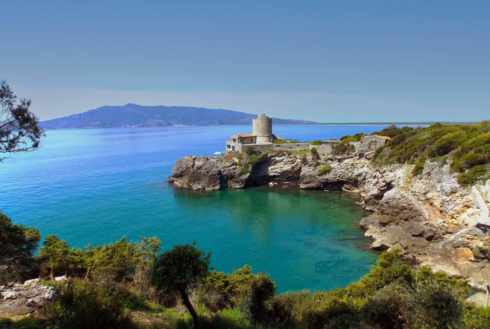
It's the tower everyone photographs: a stone parallelepiped planted on the rocks, at water level, at the end of the east beach. It was built in the course of the 16th century on the site of a medieval-era tower, underwent restorations in the following centuries and, its defensive functions exhausted, was turned into a dwelling. The nickname comes from Giacomo Puccini, who had bought the ancient Torre della Tagliata at Ansedonia as a place of rest and work. The story, though, ends differently from how hurried tourist guides tell it: the composer resold it very soon, because he couldn't bear the solitude. As for Turandot, the project was started in March 1920 with the librettists Giuseppe Adami and Renato Simoni, and remained unfinished at Puccini's death, which occurred on November 29, 1924 in Brussels, a few days after the operation for cancer of the larynx. At the time of departure for Belgium he had completed and orchestrated the first two acts and a large part of the third, leaving for the final duet and the choral conclusion extensive but little-developed sketches. The tower remains tied to his name, which is already a lot for a military building of the 1500s.
The Torre di San Biagio
It stands near the Spacco della Regina and is the oldest of the three in its layout: born in the Middle Ages as a lookout tower, it was strengthened by the Spanish in the 16th century when the Maremma coast was reorganized on a military basis. Today it presents itself as an imposing and well-preserved ruin, which stands out from the beach against the green of the scrub. It cannot be visited inside, but it is one of the visual landmarks of the whole east side.
The Torre di San Pancrazio
Built in the second half of the 16th century by the Spanish to reinforce the coastal defense system of the State of the Presidi, it performed lookout, defense and offense functions until the early 19th century. Today it is absorbed inside a private complex and is not accessible. I'm writing it plainly because every year someone tries to climb up and finds a gate.
The Oratory of San Biagio alla Tagliata
The place of worship of the hamlet is the Oratory of San Biagio alla Tagliata, built on top of an ancient Roman mausoleum. It's a case of reuse that is not rare in the Maremma and is worth understanding: a monumental tomb of the imperial age, in a visible position along the coast, becomes in the Middle Ages the base of a Christian chapel. The ancient structure offers solid foundations and a place already charged with funerary meaning, which Christianity reinterprets. The oratory is small and simple, and its interest is all here: in the stratigraphy. Whoever looks only at the facade sees nothing. Whoever knows that underneath there is a Roman mausoleum sees 2,000 years in three meters of wall.
The modern architecture of Ansedonia (GR): the villas on the promontory
Between the 1960s and today, the southern flank of the hill has filled with villas, many of them signed by recognized architects. It's a piece of the history of contemporary Italian architecture that almost no guide tells, and that can be read only from outside, because these are private residences.
Villa Tonda all'Oliveto
Designed by the architect Oreste Martelli Castaldi, it was built on Via del Fiordaliso between 1969 and 1978. The name describes the shape: a house with a circular plan resting on the slope, which renounces corners to cling to the ground and to open to the panorama all around. Nine years of construction for one villa says something about the difficulty of building on a limestone promontory.
Villa Ascarelli
Designed by Giovanni Ascarelli of the Transit studio in 2002, it was built on the slope of the Ansedonia hill between 2003 and 2005. It's an example of how contemporary architecture tackles the theme that is central here: how to lean on a steep slope without scarring it. The answer, in these cases, is almost always terracing, that is, the same technique with which the Romans built their insulae on the opposite slope.
Villa Milone
Also by the Transit studio, designed by Giovanni Ascarelli in 2004 and built between 2005 and 2007, it takes up in a contemporary key the type of the villa with a sea view of the 1960s. It's a detail that says a lot about the character of Ansedonia: here the modern villa has already become a historical model to cite, after barely 40 years.
Another well-known fact, yet rarely cited
That Cosa is a Roman colony is known by everyone who has read a sign. The well-known fact that almost no one really connects is that this colony wasn't born for the sea: it was born for the land. After the deduction, the farmland around the promontory was divided with a regular grid, following a module of 16 by 32 actus. Centuriation is not a technical detail for specialists: it is the real founding act of a colony, because it establishes who owns what, for how many generations, and with what boundaries. The promontory with its walls was the political and religious center. The wealth, instead, came from the fields assigned to the colonists.
That agrarian structure changes over time, and the change is legible. In the late Republican age the colonists' small plots were progressively merged into large organized estates, of which Settefinestre is the most studied example in Italy, and then gradually declined during the imperial age. It's the story of the Roman countryside on a small scale: you start with many medium-small owners and end with a few latifundists and slaves. The wine of the Sestii amphorae, shipped at the foot of the hill, is born precisely from that transition: the big slave-run villa produces for export, the small colonist produced for himself.
There is an interesting corollary, which serves as a key to reading today's landscape. When the system of big villas goes into crisis, the coastal plain turns to marsh and malaria becomes endemic: the Maremma remains for centuries a land of shepherds and failed reclamations, until the modern interventions. Ansedonia, with its 1960s villas overlooking a clear sea, is the final chapter of that very long affair. Seaside luxury arrives where for 1,500 years there was fever.

The beaches of Ansedonia (GR)
At Ansedonia there are two beaches, one per slope, and they are very different from each other. The west one faces toward Argentario. The east one faces toward the Capalbio shoreline and then toward Lazio. Both are sandy, both alternate free stretches and beach clubs with bar and restaurant, both have a characteristic that makes them suitable for families: the depth of the water stays shallow for quite a few meters from the shore.
The beach toward Feniglia
The west slope is the terminal part of the tombolo of Feniglia, the tongue of sand that closes the Orbetello lagoon to the south. Behind the beach extends the pine forest of the forest reserve, and it's a real woodland, not a curtain of pines planted for decoration: walking in it it isn't rare to cross paths with the fallow deer that populate it. In the very first part of the beach there are two beach clubs with bar and restaurant. Right after, the free beach begins, and it goes on for kilometers: anyone who feels like walking finds wide stretches completely deserted, where the logs carried ashore by winter storms stay on the sand and draw a landscape that resembles no other along this stretch of coast. It is, in our judgment, the most beautiful place in all of Ansedonia, to be seen off season.
The beach toward Capalbio and the Puntata
The east slope is the start of the shoreline that continues south and then toward Lazio. You find a beach club with bar and restaurant right away, but free beach isn't lacking. This is the part characterized by the presence of the Tagliata, the Torre della Tagliata and the Spacco della Regina, which are located directly on the beach: an anomaly that makes this stretch unique, because you swim 20 meters from a Roman canal. The stretch that slopes down beneath the promontory is known locally as the Puntata and is the one most sheltered from the mistral winds. A little further south, on the Capalbio shoreline, is the Torba beach, noted for its characteristic dark sand.
How to choose between the two beaches of Ansedonia (GR)
Rule of thumb. With the mistral, that is with a wind from the northwest, go east: the promontory shelters you. With the scirocco, wind from the southeast, go west, toward Feniglia. With a flat sea choose based on what you want to do: pine forest, silence and long walks on Feniglia. Barefoot archaeology on the Tagliata side. If you have small children, both are fine because of the shallow bottom, but on Feniglia the shade of the pines behind the beach solves the problem of the middle hours.
Services, access and rules
The accesses to the free beaches are gaps in the vegetation, with limited-size parking lots that fill up very early in August. On the free stretches there are no showers or restrooms: bring water. I'll mention the obvious, which isn't obvious: the coastal strip is largely a protected or restricted area, so no fires, no camping and no taking of sand or artifacts. Picking up a fragment of amphora on the waterline seems harmless and isn't: those shards come from the Roman port.
The tombolo of Feniglia and the Orbetello lagoon
Ansedonia can't be understood without the lagoon. Orbetello stands on a tongue of land inside a brackish basin closed by two tombolos, the Giannella to the north and the Feniglia to the south, and since 1842 it has been connected to the mainland by an artificial embankment. The town is known as the Italian capital of marine aquaculture, and whoever passes along the lagoon front at sunset understands why: the shallow water, the poles, the nets and the flamingos make up a productive landscape before a tourist one.
The Feniglia pine forest
The tombolo of Feniglia is covered by a state-owned pine forest crossed by a track that you travel on foot or by bicycle along its whole length, with the sea on one side and the lagoon on the other. The fallow deer are plentiful and let themselves be approached more than would be wise for them. It's the right place for a late September morning, when the heat eases and the light among the pines turns low. Whoever arrives from Ansedonia enters from the eastern end of the tombolo, that is from the side opposite Porto Ercole.
Orbetello and its historic center
In the center of Orbetello the Spanish fortifications remain, and the catalog is precise: Porta Medina Coeli, of 1697, and the Polveriera Guzman, of 1692, which today houses the municipal archaeological museum with Etruscan, Roman and medieval finds. Then there are the Duomo, probably built on the ruins of an Etruscan temple, the Palazzo del Governatore, former residence of the Spanish viceroys between the 16th and 17th centuries, and the Torre dell'Orologio. The symbol of the town is the Antico Mulino Spagnolo that you see in the lagoon, the last survivor of the nine originals. Half a day in Orbetello perfectly completes a day in Ansedonia.
The right photo to take in Ansedonia (GR)
The right photo isn't the panorama from above, which is gorgeous all the same and which everyone takes. The right photo is from below, on the east beach, with the sea in the foreground, the Torre della Tagliata on the rocks to the right and the rock cut of the Tagliata to the left, the promontory closing the frame in the background. Three eras fit in a single frame: the Roman canal, the Spanish tower, the 20th-century villas glimpsed among the scrub above. The moment is late afternoon, when the sun from the west hits the face of the tower and the stone goes from gray to gold. With a rough sea, if you wait for the right wave, the spray inside the Tagliata gives you movement too.
The other framings that work at Ansedonia (GR)
The second photo I recommend is from the arx, from the point where the three-cella temple stood, with the Orbetello lagoon and the silhouette of Argentario in the background: it should be taken early in the morning, when the air is clean and the profile of the promontory stands out sharp. The third is inside the Spacco della Regina, pointing upward: the cut of light that descends among the vegetation, with the dark walls at the sides, is a difficult photograph but when it works it resembles nothing else. You need a stable support, because with that light the exposure time gets longer.
Mistakes to avoid
First mistake: photographing the Tagliata at noon. The blazing sun flattens the canal and the contrast between lit rock and inner shadow becomes unmanageable. Second mistake: entering the canal to look for the perfect angle. Third mistake, the most common, photographing the ruins of Cosa from above with a wide-angle lens hoping to show the plan of the city: it doesn't work, because the walls are low and get lost in the grass. At Cosa what works instead are details, the joints of the polygonal blocks, the worn thresholds, the steps of the comitium.
Some important events that happened here in history
The first event is the founding itself, in 273 BC. Rome had just beaten the allied forces of Volsinii and Vulci, and the deduction of the Latin colony of Cosa on this promontory is the act by which victory turns into stable possession of the territory. A Latin colony was not a garrison: it was a city with its own magistrates, its own senate, its own cults, populated by colonists who gave up Roman citizenship in exchange for land. That day, on the hill of Ansedonia, a priest traced a furrow and watched the flight of the birds.
The second event is the second deduction of 197 BC. A second sending of colonists means the city needed hands and defenders, and takes us back to the climate of an Italy just out of the Hannibalic war. The coastal colonies had been put under pressure by Hannibal's passage and by Carthaginian naval raids. Repopulating them was a strategic priority.
The third event is the sack of the third decade of the first century BC, the one that leaves the city almost abandoned until the Augustan age. It falls in a period of civil wars and insecurity at sea, and marks the end of the most prosperous phase of Cosa, just while the port at the foot of the hill was exporting wine across the whole western Mediterranean. A city can die even without a famous siege: it's enough for trade to stop passing through.
The fourth event is long and has no date: the decline between the third and fifth century AD and the definitive abandonment in the medieval period. On that abandonment is grafted the birth of the center that takes the name of Ansedonia. The fifth event is political: the inclusion of Ansedonia in the State of the Presidi, a Spanish possession from 1557, together with Orbetello, Port'Ercole, Porto Santo Stefano, Talamone and Porto Longone. From that moment and for two and a half centuries this piece of coast does not belong to Tuscany but to a Mediterranean military network governed from Madrid, then from Vienna in 1707, then by Charles of Bourbon in 1736, with the tie to the Kingdom of the Two Sicilies until 1800, the French occupation, the inclusion in the Kingdom of Etruria in 1801 and finally the landing in the Grand Duchy of Tuscany. The towers you see from the beach are the material residue of that history.
The sixth event belongs to the 20th century and is scientific in nature: the excavation campaigns of the American missions, tied to the name of Frank E. Brown, which made Cosa one of the reference sites for the study of Roman colonies. The seventh is the seaside transformation of the 1960s and 1970s, with the construction of the villas on the southern slope, from Villa Tonda all'Oliveto onward. In less than a century the promontory went from forgotten ruin to international archaeological laboratory and to one of the most exclusive vacation addresses on the Tyrrhenian coast.
Who passed through Ansedonia (GR)
The first name is collective and anonymous: the Latin colonists of 273 BC and those of 197, men and women who left their city to receive a plot of land inside a grid of 16 by 32 actus. We don't know their names, but we know their houses, their cisterns and the square where they voted. In the history of a place, unsigned passages count too.
The second name instead has a precise surname and is stamped on clay: the Sestii, the family whose stamps can be read on the amphorae produced here and found throughout the western Mediterranean. They are among the few entrepreneurs of antiquity whose commercial brand we can follow across the seas, and their wine left from the beach below the promontory.
The third is Giacomo Puccini. The composer bought the ancient Torre della Tagliata at Ansedonia as a place of rest and work, and resold it very soon because he couldn't bear the solitude. It's a biographical detail that says a lot about the man and also about the place: the promontory, off season, is silent in a way that not everyone can stand. The tower still carries his name in local usage, and the name has outlived the brevity of the stay.
The fourth name is Frank E. Brown, the archaeologist tied to the American missions that excavated Cosa. Around him passed generations of students and researchers, many of whom later taught in universities around half the world carrying this promontory with them as a formative experience. If today in a university textbook the entry Latin colony is illustrated with a plan, chances are that plan is of Cosa.
The fifth group is that of the architects of the second half of the 20th century: Oreste Martelli Castaldi, author of Villa Tonda all'Oliveto between 1969 and 1978, and Giovanni Ascarelli of the Transit studio, who signed Villa Ascarelli between 2003 and 2005 and Villa Milone between 2005 and 2007. They worked on the same problem as the Roman colonists, that is how to rest a building on a limestone slope, and arrived at the same solution: terracing. 1,900 years later, geology still dictates the rules.
Settefinestre and the Roman countryside around Ansedonia (GR)
A short distance from the promontory is Settefinestre, the most studied Roman villa in Italy as regards productive organization. It dates to the late Republican age, in the framework of the merging of colonial plots into large organized estates, and was then modified in the following centuries. It's not a scenic place and shouldn't be confused with a postcard luxury villa: its interest lies in the structure, which lets you read how a slave-run farm worked, where the grapes were pressed, where the wine was stored, where the slaves slept. Whoever has read something about the Roman economy recognizes here concepts seen only on paper.
The relationship between Settefinestre, the port at the foot of the hill and the amphorae of the Sestii is the economic key of the whole area: you produce in the interior, you bottle, you transport to the port, you ship. It's a supply chain, and you can still travel it physically in half an hour by car. Few Italian archaeological areas allow this experience with as much clarity.
What's around Ansedonia (GR)
The promontory is an excellent base camp for three or four days, because everything that matters in this corner of the Maremma is reachable in under an hour.
Orbetello and Monte Argentario
The municipalities of Orbetello and Monte Argentario are a few minutes by car from Ansedonia. The stretch that links Orbetello to the localities of Porto Santo Stefano and Porto Ercole is the backbone of the Silver Coast. Orbetello, Porto Santo Stefano and Porto Ercole offer walks in nature, on the lagoon or the waterfront, and panoramas that only the Tuscan coast can give. Porto Ercole preserves the Spanish fortified center and remains the most convenient embarkation point for excursions to the south. Porto Santo Stefano is the main commercial and tourist port of the promontory.
Capalbio and the Tarot Garden
A few kilometers to the south you climb to the village of Capalbio, a castle donated by Charlemagne in 805 to the Abbey of Santi Anastasio e Vincenzo, protected by two rings of walls built between the 11th and 15th centuries. Inside the walls you visit Palazzo Collacchioni, a richly frescoed stately building of the Renaissance era, and the Church of San Nicola with decorations of the Umbrian-Sienese school. Outside the walls is the Oratory of the Provvidenza, with frescoes attributed to the workshop of Pinturicchio. In the municipal territory is also the Tarot Garden of Niki de Saint Phalle: the official site indicates it is open every day from April 1 to October 15, from 14:30 to 19:30, with last entry at 18:15 for those who don't already have a ticket. Check the calendar before leaving, because extraordinary closures are planned.
Lake Burano and the beaches of Capalbio
The oasis of Lake Burano is the nature reserve that closes this stretch of coast to the south and is the opposite end of the Tagliata's hydraulic system. Along the Capalbio shoreline are the Torba beach, characterized by dark sand, and Macchiatonda, near the reserve: they are windy beaches, frequented by windsurfers.
Etruria between Tuscany and Lazio
Going down the Aurelia you enter southern Etruria. Montalto di Castro and above all Vulci tell of the Etruscan world that Rome defeated in exactly the years in which it founded Cosa, and at Tarquinia you visit the painted tombs that made this civilization famous. Going back up toward the interior you reach Pitigliano, dug into the tuff, and further east Lake Bolsena with Viterbo and Tuscania. Toward the open sea, from the port of Argentario you reach the island of Giglio.
The connection with Rome
For those coming from Rome, Ansedonia works very well as a long day trip or as a stage on the approach to the Maremma. Anyone who wants to understand how the colony of Cosa fits into the Roman system can continue the discussion in the city, in front of the Trajan's Markets, where imperial commercial architecture shows where the same building tradition arrived, or at Ostia Antica, the port of the capital, which shares functions and fate with the small port of Cosa. And in front of the Colosseum it's worth remembering that when it was built Cosa had already been in decline for a century.
When to go to Ansedonia (GR)
The curt answer: September. The sea stays warm, the August crowd has dissolved, the archaeological area becomes practicable even in the middle of the day, parking exists. May and June are excellent for archaeology and for the Feniglia pine forest, with the water still cool. July and August remain the full beach season, and have to be tackled with the strategy of the two halves of the day described above.
Winter deserves a separate discussion. With a heavy sea the Tagliata is at its best, the free beach of Feniglia with the logs carried ashore by the storms is a landscape worth the trip, and the promontory recovers its solitary character. On the other hand many services are closed and the hours of the cultural sites are reduced: get information first on the museum's official site. Whoever is looking for the perfect season for photographing will find it between October and November, when the clean air makes the profile of Argentario visible from the viewpoint of the arx.
Ansedonia (GR) with children
It works better than you'd think, as long as you pace it. The shallow seabed of both beaches is the strong point, and the Feniglia pine forest with its fallow deer is a winning card for the little ones. The Spacco della Regina, with a flashlight and an adult's hand, becomes the adventure of the vacation, but judge the child's temperament: darkness, narrow passages and uneven ground are not for everyone. The archaeological area of Cosa, on the other hand, needs an adult able to tell the story, otherwise for a child it remains a field of rocks under the sun. A trick that always works: have them look for the joints between the polygonal blocks and ask them to find two identical stones. There aren't any.
Accessibility in Ansedonia (GR)
I'll get to the point, without sweetening it. The archaeological area of Cosa is on an uneven plateau, with packed-earth paths, slopes and steps: it isn't a site suitable for a wheelchair along the whole perimeter, though the museum part and the stretches around the entrance are more practicable. The Tagliata is reached from the beach and has a staircase for the view from above. The Spacco della Regina is not accessible: narrow entrance, uneven floor, low ceiling in some places. On the beaches, the presence of walkways and dedicated services depends on the individual beach clubs and should be asked of them directly. At the Orbetello-Monte Argentario railway station there are platforms accessible to tracks 1 and 4 with level access, but the operator notes the absence of assistance service for people with disabilities: anyone traveling by train should arrange support on their own.
A perfect day in Ansedonia (GR): the itinerary I recommend
7:30, deserted east beach, raking light on the Torre della Tagliata: you walk to the canal, climb the staircase, watch the work of the water. 8:30, Spacco della Regina with the flashlight, when the light from above begins to descend into the fissure. 9:30, swim on the east side before the crowds arrive. 11:00, you go up to the top: first the Cosa National Archaeological Museum, then the archaeological area, starting from the forum and closing on the arx. 13:30, lunch. 15:00, transfer to Orbetello for the lagoon and the Spanish fortifications, or the Feniglia pine forest if you prefer shade. 18:30, back to the west side for the sunset behind Argentario. If you have a second day, devote it to Capalbio and the Tarot Garden in the afternoon, respecting the afternoon opening hours.
How much a day in Ansedonia (GR) costs
The expense items are three: the ticket for the archaeological area with the museum, parking or the beach club, lunch. The first is set by the Ministry of Culture and should be checked on the museum's official site, which also lists the reductions and free admissions provided by national regulations. The second depends on the beach club and the season, with strong differences between June and August. The third is up to you. The Tagliata, the Spacco della Regina and the free beach cost nothing, and it's good to know: a day in Ansedonia can be almost free and still be full.

For those coming from abroad and for those organizing the trip
Ansedonia is one of the destinations where the international visitor almost always arrives by chance, pushed by Argentario or the Maremma, and discovers the archaeology only once on the spot. Anyone preparing an itinerary in English for friends or foreign clients will find a general overview of the region in the ItalyPlanner guide to Tuscany, which gives space precisely to the less-trodden areas like the Maremma, and a comparison of the Italian coasts on the page on the best beaches in Italy. For the historical and artistic angle, useful before going up to Cosa, the section art and history in Italy gathers museums, churches and archaeological sites told by guides who walk them for a living.
On the operational side, an archaeological site reduced to foundations like Cosa yields a great deal with a guide and very little without one. Tour operators and groups working on Rome and Tuscany can rely on the services of professional tour escort services, while anyone building itineraries based in the capital with side trips toward the Tyrrhenian coast will find the overview of services on the page dedicated to TourLeaderPro in Rome.
Quick questions about Ansedonia (GR)
Where exactly is Ansedonia (GR)?
Ansedonia is a hamlet of the municipality of Orbetello, in the province of Grosseto, on the promontory that closes the Orbetello lagoon to the southeast. It is reached from the SS1 Aurelia.
How far is Ansedonia (GR) from Rome?
A little over 130 kilometers along the line of the Aurelia, about two hours by car in normal traffic conditions. On summer weekends the time lengthens noticeably.
How do you get to Ansedonia (GR) by train?
The reference station is Orbetello-Monte Argentario, on the Tyrrhenian line. From the station you continue to Ansedonia by local public transport or by taxi, because the distance is about 10 kilometers.
How much does it cost to enter the archaeological area of Cosa?
The archaeological area and the Cosa National Archaeological Museum are state places of culture: the full fare, reductions and free admissions can be consulted on the museum's official site, which also lists the updated calendar.
What are the hours of the Cosa National Archaeological Museum?
The hours change with the season and should be checked on the museum's official site before the visit. In winter the openings are more limited than in summer.
Do you need to book to visit Ansedonia (GR)?
For the Tagliata, the Spacco della Regina and the beaches you need nothing: they are freely accessible. For the archaeological area with the museum, check on the official site if reservations are required for groups or on particular days.
How much time do you need to visit Ansedonia (GR)?
At least two hours for the museum and archaeological area, an hour and a half for the Tagliata and the Spacco della Regina, the rest of the day for the beaches. A full day is the minimum so as not to rush.
Is the Tagliata Etrusca really Etruscan?
No. The name is traditional but the work is Roman hydraulic engineering, tied to the port of the colony of Cosa, founded in 273 BC after the defeat of the allied forces of Volsinii and Vulci.
Can you go into the Spacco della Regina?
Yes, access is free and open from the beach. You need a flashlight, because the first meters are dark, and closed shoes with a lugged sole. The floor is uneven.
Is the Spacco della Regina suitable for people who suffer from claustrophobia?
The first chamber receives light from above and remains tolerable. The narrow passages connecting the three chambers do not. Anyone with problems with enclosed spaces should stop at the entrance.
Can you go up the Torre della Tagliata?
No. The Torre della Tagliata, called Torre Puccini, is private property turned into a dwelling after the end of its defensive functions. It is admired from the outside, from the beach.
Why is it called Torre Puccini?
Because Giacomo Puccini bought the ancient tower as a place of rest and work, only to resell it very soon: he couldn't bear the solitude. The name has remained in local usage.
Did Puccini write Turandot at Ansedonia (GR)?
The Turandot project was started in March 1920 with the librettists Giuseppe Adami and Renato Simoni and remained unfinished at the composer's death, on November 29, 1924 in Brussels. Puccini's stay in the tower at Ansedonia was brief and ended with the resale of the property.
Are the beaches of Ansedonia (GR) free or paid?
Both alternate free stretches and beach clubs with bar and restaurant. On the Feniglia side, after the first two beach clubs, the free beach continues for kilometers.
Are the beaches of Ansedonia (GR) suitable for children?
Yes, because the depth of the water stays shallow for quite a few meters from the shore on both sides. On Feniglia the pine forest behind the beach offers shade in the middle hours.
Which beach to choose at Ansedonia (GR)?
With a wind from the northwest the east side is best, sheltered by the promontory. With a wind from the southeast the west side toward Feniglia is best. With a calm sea decide based on the plan for the day.
Are there fallow deer in the Feniglia pine forest?
Yes, the pine forest of the forest reserve behind the west beach is populated by fallow deer, which it isn't hard to come across along the trails, especially early in the morning.
Is Ansedonia (GR) wheelchair accessible?
Only in part. The archaeological area has packed-earth paths, slopes and steps. The Spacco della Regina is not accessible. The Tagliata has a staircase for the view from above. On the beaches it depends on the individual beach clubs.
Can you take photos at Ansedonia (GR)?
On the coast and in the archaeological area amateur photography poses no problems. For professional shooting, with equipment or drones, you need authorizations from the body that manages the site.
What is the best time to visit Ansedonia (GR)?
September, for a still-warm sea and reduced crowds. May and June are ideal for archaeology and for the pine forest. Winter, with a heavy sea, is the moment when the Tagliata best shows how it works.
What is the difference between Ansedonia and Cosa?
Cosa is the name of the Roman colony founded in 273 BC on the promontory. Ansedonia is the name of the medieval center that arose on the same site and then of the modern locality. They indicate the same place in two different eras.
What can you see from the arx of Cosa?
From the highest point, where the three-cella temple modeled on the Capitolium of Rome stood, you take in the Orbetello lagoon, the tombolo of Feniglia, the silhouette of Argentario and the coastline toward Lazio.
Can you visit Ansedonia (GR) in a day coming from Rome?
Yes, but the day has to be organized well: early departure, coast in the morning, museum and archaeological area in the middle of the day, return after sunset. With two days you add Orbetello, Capalbio and the Tarot Garden.
What is there to see near Ansedonia (GR)?
Orbetello with the lagoon and the Spanish fortifications, Monte Argentario with Porto Ercole and Porto Santo Stefano, Capalbio with the Tarot Garden, the oasis of Lake Burano and, going south, the Etruria of Vulci and Tarquinia.
Are there services on the free beach of Ansedonia (GR)?
On the free stretches no: no showers, no restrooms, no refreshment points. Bars and restaurants are found at the beach clubs, in the first part of both beaches.
Conclusions on Ansedonia (GR)
Ansedonia has a flaw and a merit, and they coincide. The flaw: it gives nothing to those who pass through in a rush. There isn't a standing column to photograph, the museum is small, the ruins are low, the towers are private, the Tagliata with a flat sea looks like any canal. The merit: to those who stop it gives back a quantity of history that very few Italian places line up with this clarity, from the colonial founding of 273 BC to the centuriation of the fields, from the Sestii wine trade to the Spanish towers, up to the designer villas of the 1960s. If you have only one day, make it slow. And if you have to choose one thing, choose early morning on the east beach, with the Tagliata at work and the tower catching the light: that is the moment when the promontory stops being a beach resort and goes back to being what it has always been, a stone machine facing the Tyrrhenian.
Article written by the TourLeaderPro editorial team, contact them for Private/Corporate/V.I.P. Tours and Experiences.
Planning a trip to Rome? The English guides to visiting the city are on ItalyPlanner.com.