Inviolata Regional Archaeological Nature Park
In short. The Inviolata Regional Archaeological Nature Park occupies 535 hectares in the territory of the Comune of Guidonia Montecelio, in the Metropolitan City of Rome Capital, and is reached from the Grande Raccordo Anulare in a little over 20 minutes by car.

The Inviolata Regional Archaeological Nature Park occupies 535 hectares in the territory of the Comune of Guidonia Montecelio, in the Metropolitan City of Rome Capital, and is reached from the Grande Raccordo Anulare in a little over 20 minutes by car. It has no ticket office, no gate, no opening hours: it is a regional protected area made of fields, ditches, olive groves and ruins, almost entirely privately owned, crossed by municipal roads open to traffic. You enter from the public roads that cut through it, and access is free. The managing body is the Monti Lucretili Regional Natural Park, phone 0774 637027, with its operating office at the Comune of Guidonia Montecelio, Via Roma 145. The museum reference for the territory is the Rodolfo Lanciani Civic Archaeological Museum of Montecelio, in Via XXV Aprile near Piazza Jean Coste, where the Capitoline Triad of the Inviolata is on display. The museum opens on Saturday and Sunday with hours that change by season (9-17 in winter, 10-18 in spring and in September, 9-13 and 16-20 in the months of June, July and August), phone 0774 301242, reservations at prenotazionemuseolanciani@gmail.com. Hours, rates and opening days of the museum must be confirmed before leaving on the museum's official website. By train you arrive on the FL2 regional line Roma Tiburtina-Tivoli-Avezzano, which since July 4, 2026 serves the new Guidonia Montecelio station in the Collefiorito area. The old Bagni di Tivoli stop changed its name the same day and is now called Tivoli Terme. From the station to the park there is no dedicated connection: you need a car, a bicycle or a taxi.
Whoever organizes a day outside Rome in this sector of the Roman countryside finds in the page dedicated to Tivoli the natural complement to this trip, and in the Monti Lucretili Regional Park the body that now also has the Inviolata in its care.

Where the Inviolata Regional Archaeological Nature Park is
The geographic location is more precise than the administrative formula suggests. The protected area is bounded to the north by the Cornicolani Mountains, more exactly by the Capaldo ditch. To the east by the basin of the Aquae Albulae, the sulfurous plain that has produced travertine since ancient Rome. To the south by the settlement of Marco Simone Vecchio. To the west by the hill arc Formello-Tor de Sordi-Castell'Arcione. In practice the park is a wedge of countryside left stuck between the eastern outskirts of Rome, the A1 motorway and the third most populous city of Lazio. Guidonia Montecelio has passed 80,000 inhabitants in a few decades, and building pressure on this sector has been constant.
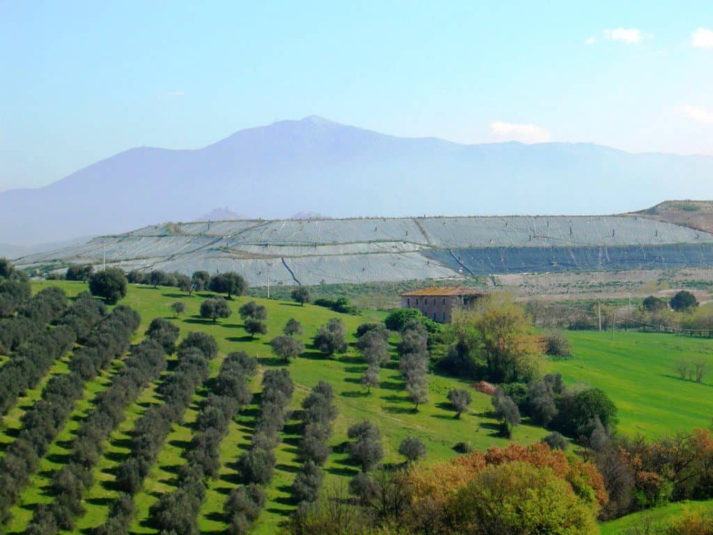
The elevation is modest: we are between about 60 and 130 meters above sea level, on a gentle hill rise that slopes down toward the plain of the Acque Albule. From some high points of the protected area, on clear days with the north wind, the gaze reaches at once the Alban Hills, the Praenestine Mountains, the Lucretili, the Cornicolani and Soratte. It is one of the few positions in the Roman north-east from which you read at one glance the entire geological structure of the basin.
How to get to the Inviolata Regional Archaeological Nature Park by car
From the A1 motorway you exit at Guidonia and take Via di Casal Bianco. From the roundabout at the toll exit Via dell'Inviolata begins, which crosses the park from side to side and comes out on Via Palombarese, at Santa Lucia di Fonte Nuova. Whoever comes from Rome by Via Tiburtina continues until the signs for Guidonia and then for Marco Simone. Parking is improvised on the side widenings of the municipal roads, without blocking the entrances to the farm fields: almost all the land around is private and cultivated, and the owners are right to be impatient with those who leave the car in front of a gate.
The Inviolata Regional Archaeological Nature Park by train and public transport
The FL2 line connects Roma Tiburtina to Tivoli and continues toward Avezzano. The doubling of the track as far as Bagni di Tivoli, now Tivoli Terme, is completed and in operation. The doubling of the following stretch toward Guidonia still appears to be in the design phase and unfunded, which means travel times and frequencies below expectations on the terminal part of the line. The new Guidonia Montecelio station, activated on July 4, 2026 at Collefiorito, has replaced the old Guidonia-Montecelio-Sant'Angelo stop. It must be said frankly: getting off the train is not enough. From the station to the Inviolata there remain a few kilometers of ordinary roads without a continuous sidewalk, and local public transport does not cover the perimeter of the protected area. Whoever has no car should do the math with a bicycle brought on the train, or consider a taxi from the station.
The museum as the starting point of the visit
The smart way to set up the day is to reverse the order: museum first, then the park. The Rodolfo Lanciani Civic Archaeological Museum occupies the former convent of San Michele Arcangelo, on the hill of Montecelio, and keeps ceramic, sculptural, architectural, numismatic and metal material from the territory, from prehistory to the modern age. There the Capitoline Triad found in the park is on display. Seeing the object first and then the field it came out of completely changes the perception of the landscape: without that step the Inviolata risks looking, to a distracted eye, like any countryside.
What the Inviolata Regional Archaeological Nature Park really is
Here something has to be said that almost no tourist page says openly. The Inviolata Regional Archaeological Nature Park is an area protected by law, but for a very long time it had none of the tools that make a park a park: no operational boundary marking on the ground, no signage, no equipped trails, no visitor center, no dedicated surveillance staff. The protection existed on the paper of the Lazio Region and not on the ground. The paradox is that precisely this absence of management, together with the fact that all the lands are in the hands of private owners who cultivate them, preserved the traditional agricultural layout: nobody built, because the law forbade it, and nobody equipped it, because nobody was taking care of it.
The result is a mosaic. Watercourses with riparian vegetation, gallery forests along the ditches, fragments of Turkey oak and downy oak woodland, cultivated and uncultivated fields, grasslands, hedges, tuff gorges with rock vegetation, small bodies of water. The regional body's own official description insists on this character of juxtaposed tiles, and on the fact that the landscape preserves the elements of the historic Roman Campagna even though the eastern outskirts of Rome have grown up against it.
The 535 hectares of the Inviolata Regional Archaeological Nature Park
The official figure for the surface is 535 hectares. In the texts in circulation you also meet the value of about 550 hectares, referring to the original perimeter set by the founding law between Via Palombarese and provincial road 28 bis. The difference is not a transcription error: in 2005 a regulatory change removed the landfill sector from the protected area, and the figure consolidated today by the regional bodies is 535 hectares. When in doubt, the number to cite is the official one of the managing body.
The private ownership of the lands
All the lands within the perimeter are private. This conditions everything: real accessibility, the possibility of laying out trails, surveillance, maintenance. A visitor who enters a plowed field to photograph a ruin is technically trespassing. The practical rule is simple and admits no exceptions: you walk on public roads and on commonly used cart tracks, you look at everything else from the edge, and if an owner asks you to leave you leave without arguing. The alternative is that in a few years even the edges will be fenced off.
The name: why it is called Inviolata
The place name has nothing to do with untouched nature, as many imagine. It derives from a matter of ecclesiastical landholding: the estate belonged to the women's monastery tied to the community of Santa Maria in Via Lata, the Roman complex that stands along the urban stretch of Via Flaminia, today's Via del Corso. From in Via Lata to Inviolata the shift happened by progressive phonetic corruption in local pronunciation, and the deformed form ended up prevailing until it became official. It is a textbook case of folk etymology: the name then acted back on the place, suggesting to generations of inhabitants the idea of an intact and inviolable area, and that idea became one of the arguments of the environmental battles of recent decades.
It is worth remembering in front of the ruins: the name that today sounds like a promise of untouchability was born from a monastic land register. The history of the place names of the Roman countryside is almost always like this: Tor Mastorta, Casal Bianco, Castell'Arcione, Marco Simone tell of estates, watchtowers and farmhouses, not landscapes.
The founding law and the 30 years of the Inviolata Regional Archaeological Nature Park
Regional Law 22 of June 20, 1996
The Regional Council of Lazio established the park with Regional Law 22 of June 20, 1996, identifying a vast area between Via Palombarese and provincial road 28 bis. The law entrusts management to the Comune of Guidonia Montecelio. On paper it is a good text: it recognizes together the archaeological value and the natural value, which was anything but a given in a period when protection proceeded in separate compartments. In fact, the municipal administration never sets up the machinery of a body for protection and promotion. The plan, the marked boundaries, the signs, the routes are missing.
2005 and the removal of the landfill area
In 2005 a regional regulatory change, inserted in a financial measure, removes from the protected area the sector in which the landfill and the mechanical biological treatment plant fall. It is the episode that local environmentalists cite most often, because it shows how a protection perimeter can be redrawn with a few lines of law without any dedicated public debate. The practical consequence is that the waste and the park become formally two separate things, while remaining physically adjacent.
2016 and the passage to the Monti Lucretili Park Authority
In October 2016 management passes from the Comune to the Monti Lucretili Regional Natural Park Authority, by effect of a new regional law. It is a change of pace: for the first time the protected area has as its reference a body specialized in managing protected areas, with technical staff, and not a municipal office swamped with other duties. From that moment the Inviolata appears in publications, in educational activities and in the excursions promoted by the system of regional parks of Lazio.
2025 and the Management Plan
The administrative turning point comes almost 30 years after the founding law. On May 20, 2025 the proposal for the Management Plan of the Inviolata Park is published in the Official Bulletin of the Lazio Region number 40, accompanied by the Regulation Plan, the Environmental Report and the Non-Technical Summary. On June 19, 2025, at the Rodolfo Lanciani Museum of Montecelio, the plan is presented publicly together with a naturalistic and archaeological guide to the protected area, with speeches by the commissioner of the Monti Lucretili Park Marco Piergotti, the mayor of Guidonia Montecelio Mauro Lombardo, regional councilors and administrators, the association ANVA, the archaeologist Zaccaria Mari and the company in charge of drafting the plan.
What really changes. The Management Plan is the document that maps the territory piece by piece and establishes where you can do what: full reserve zones, guided reserve zones, zones of economic and social promotion, prescriptions for agriculture and for rural building. Without that document every decision was discretionary and every dispute ended up before an administrative judge. With that document the Inviolata begins to have the rules that a law of 1996 provided for. Our judgment is that it is the most important news of the last 30 years for this territory: more than the daily controversy over the landfill, which nonetheless served to keep attention alive.

A curiosity about the Inviolata Regional Archaeological Nature Park
In these fields was found the only sculpture in the world that represents the Capitoline Triad complete. Not one of the few: the only one. Jupiter, Juno and Minerva seated one beside the other, in a single marble group, with their respective attribute animals at the foot of the throne: the eagle for Jupiter, the peacock for Juno, the owl for Minerva. Before 1992 that composition was known only through coins and medallions of the Hadrianic and Antonine age, that is, through images a few centimeters across. Archaeologists knew that the group of the Temple of Jupiter Optimus Maximus on the Capitoline Hill must have had that appearance, but nobody had ever seen it translated into marble in the round.
The piece measures 60 by 80 by 120 centimeters, in Luni marble, that is, the marble of the Apuan quarries that Rome used for quality sculpture. The proposed dating is late Antonine age, indicatively between AD 188 and 217. Jupiter in the center holds the scepter and the thunderbolt. Juno is veiled and wears the diadem and carries the patera. Minerva wears the Corinthian helmet and holds the spear. Above the heads there must have been three winged Victories crowning the deities, and the crowns were different for each: oak, rose, laurel. The arms of the two goddesses and the Victories are lost.
The element that strikes scholars is not the quality of the carving, which is good but not exceptional: it is the composition. The three deities have equal dignity, seated on the same plane, without the overwhelming hierarchy in favor of Jupiter that one would expect. It is a document on the political theology of Rome in the age of the Severans, not simply a beautiful object. The fact that it came out of the cryptoporticus of a private villa of the countryside, and not from an urban temple, says something precise about how far official religion had penetrated the domestic life of the landowning aristocracy.
The Capitoline Triad of the Inviolata: discovery, theft and recovery
The cryptoporticus of the Roman villa
The group came to light in 1992 in the cryptoporticus of a Roman villa, inside the perimeter of the park. The dimensions of the residential complex to which it belonged are considerable: we are talking about a layout on the order of 10,000 square meters. A cryptoporticus is a semi-buried, vaulted gallery, which served to support terracing and to offer a cool space in the hot hours: it was the place where people strolled in summer, and where statuary was often placed. That the Triad was in there is therefore not a strangeness, but the fact is not trivial: it means the owner had commissioned for his country house a replica of the most politically charged cult group of Rome.
The theft and Operation Juno
It was not archaeologists who found it. It was clandestine diggers, who dismantled it and put it on the illicit market by selling it to a Swiss antiquarian. The piece was destined for a collector overseas. The carabinieri of the Cultural Heritage Protection Command took almost two years to reconstruct the trail, in an investigation that took the name Operation Juno, and recovered it in December 1994 at the Stelvio Pass. The evidence that nailed the whole chain was a fragment left in Italy, the right forearm of Juno: without that piece, proving the Italian origin of the work would have been much harder, and in all likelihood today the Triad would be in a private collection abroad.
From Palestrina to Montecelio
After the recovery the work was displayed for years at the Palestrina National Archaeological Museum. In 2012 it returned to the Comune of Guidonia Montecelio and is now at the Rodolfo Lanciani Civic Archaeological Museum, in the former convent of San Michele Arcangelo. Some popular publications still indicate Palestrina as its home: that is outdated. Whoever wants to see the Capitoline Triad of the Inviolata has to go up to Montecelio.
How to look at the Capitoline Triad
In front of the case I recommend three things. The first: look for the attribute animals at the base, because they are the immediate key to the identity of the three figures. The second: look at the hands of Jupiter and the position of the scepter, which follow an iconographic scheme derived from the Capitoline cult statuary. The third: observe the fracture surfaces of the lost arms and the attachment points of the Victories, because they tell how the group was dismantled and how much of it is missing. It is an object to be looked at for at least a quarter of an hour, not three minutes. Whoever also has the Capitoline Museums on the program should make the comparison with the colossal fragments of the cult of Jupiter: the difference in scale between the temple and the villa is the whole story of private Roman religion.
One thing nobody tells you about the Inviolata Regional Archaeological Nature Park
In the park there are no equipped routes and no guided tour at a fixed calendar is planned. This information, which no promotional page highlights, is the most important of all for whoever organizes a day. There are no trail markers, no notice boards at the entrance, no posted map, no information point on site. The only occasions for an accompanied visit are the excursions organized periodically by the managing body, by local environmental and naturalist associations and by the museum: they are announced from time to time and require registration.
The second thing that is not said concerns timing. The neighboring landfill has stopped receiving waste, but the body of the landfill still exists, it is an artificial hill, and it is awaiting definitive capping. The capping works approved in July 2025 are estimated to last about two and a half years. Translated for a visitor: on certain days, with certain conditions of wind and humidity, the smell arrives. It is not a permanent fatality and it does not compromise the whole protected area, which is large and varied, but whoever expects a countryside fragrant with hay in every weather condition will be disappointed. The northern sector and that of the small lakes to the east, toward Tor Mastorta, are the farthest from the problem.
The third thing nobody says is the most surprising. The waters of the ditches host the freshwater crab and the Apennine frog, two species that biologists use as indicators: their presence signals good quality water. Finding them a few hundred meters from one of the largest landfills in Lazio is a fact that overturns every prediction, and one that the surveyors of the Società Romana di Scienze Naturali have recorded while carrying out research in this area. It does not mean the environmental problem does not exist: it means the system of ditches has a resilience that nobody attributed to it.
The advice I give you for visiting the Inviolata Regional Archaeological Nature Park
The operational advice is one and should be taken literally: don't come here without a companion or without having prepared the route at home. It is not a park that reads itself. Without signage, without a visitor center, without signs in front of the ruins, an inexperienced visitor crosses two kilometers of fields by car and concludes there is nothing to see. With a prepared route and a minimum of historical framing, the same route becomes one of the densest in Lazio, because the stratification here covers 11,000 years.
The right season is the second half of April and the first half of May, for a precise reason: it is the flowering period of Orchis purpurea, the most widespread wild orchid in the area, and it is the moment when the fields are green and the ditches still have flow. The second good window is October, after the first rains, when the air is clear and the panorama toward the Cornicolani and Soratte opens up. To avoid without hesitation: July and August, for the heat, for the total absence of shade on the cart tracks and for the greater probability that the smell from the landfill area makes itself felt.
The right time is early morning, by nine, for two reasons: the raking light on the hill rises and the activity of the birdlife, which after 10 drops drastically. Bring water, because there are no drinking fountains, and closed shoes with a lugged sole, because after rain the cart tracks turn into heavy clay mud. A pair of 8x or 10x binoculars changes the day: without them, the herons and the raptors remain dots. And plan a stop at the Montecelio museum: half a day in the park without the museum is a lopsided visit.
One last recommendation that counts more here than elsewhere: leave the ruins alone. You don't climb on them, you don't dig, you don't pick anything up from the ground. This is the territory where tomb robbers found and sold the Capitoline Triad, and where in 1978 they tore the frescoes from a rock-cut church. Local sensitivity on this point is very high, and rightly so.
The landscape and flora of the Inviolata Regional Archaeological Nature Park
The landscape is the classic one of the Roman Campagna: gentle hill rises, extensive olive groves, arable land with wheat, corn and sunflower, fields bounded by hedges of native or introduced species. It is the landscape that the view painters of the Grand Tour painted for two centuries, and that around Rome has almost entirely disappeared under building. Here it survives in full, with its structure of closed fields, rows and scattered farmhouses.
The residual woods of the Inviolata Regional Archaeological Nature Park
Within the area are preserved patches of woodland, concentrated in the central part and along the watercourses. The composition is that of the mixed oak woodland of the Lazio hill belt: Turkey oak and downy oak dominant, English oak in the cooler situations, elm, with wild grapevine and privet as companions. Along the ditches the woodland becomes a gallery, with hygrophilous and riparian vegetation closing over the water. They are small surfaces and for that reason precious: in an intensive agricultural context, the woodland fragments work as refuge and corridor for fauna, and their connection along the ditches is what holds the ecosystem together.
The wild orchids
Orchis purpurea is fairly widespread in the park. It is a terrestrial orchid up to 80 centimeters tall, with a dense inflorescence, a purple-brown helmet and a dotted white lip: it grows at the edges of woods and in grassy clearings on calcareous soils, and flowers in April and May. It is not picked and not moved: Italian wild orchids depend on symbiotic fungi present in the soil and die if transplanted. A rule worth remembering: you photograph from above and from the side, without trampling the basal rosette.
The eucalyptus trees of Tor Mastorta
In the area around Tor Mastorta and the first small lake grow eucalyptus trees. They are Australian trees, entirely foreign to the Italian flora, and their presence has a precise historical explanation: they were planted in the marshy zones during the land reclamations of the Fascist 20 years, when it was believed that their capacity to absorb water contributed to draining the stagnant pools and therefore to the fight against malaria. It is a readable botanical signature: where there are eucalyptus trees in rows in the Lazio countryside, almost always there was a 1900s reclamation. The attentive visitor uses them as a clue for reading the landscape, not as a decorative element.
Agriculture and livestock inside the protected area
In the fields of the park mostly cereals are grown, with barley in a prominent position, alternating with extensive olive plantations. Olive growing is the historic vocation of this sector of the Cornicolani, and the oil of the area has a documented tradition. Alongside farming there is sheep herding, a characteristic element of the Roman Campagna and today sharply contracting everywhere around Rome. Meeting a flock in transit on the cart tracks of the Inviolata is not rare: it is one of the images that make this place different from an urban park. The relationship between agriculture and protection, here, is the exact opposite of what you imagine: it is the farmers who have maintained the landscape, not public surveillance.

The fauna of the Inviolata Regional Archaeological Nature Park
In an environment marked by human presence like this one, the persistence of diversified wildlife is the fact that surprises most. Many of the species present enjoy a protection regime, and several are by now rare in the rest of Lazio: it is the technical reason why this surface deserves protected area status beyond its archaeological value.
The birds
The best represented group is that of the Passerines, and among them the hooded crow is the most common and visible species, present everywhere in the fields. On the bodies of water and along the ditches you see the gray heron and the little egret, the mallard and, with a bit of luck and a lot of silence, the kingfisher, which almost always announces itself first with a sharp whistle and only afterward with the blue flash over the water. Among the diurnal raptors the list includes the kestrel, which hunts hovering over open fields, the buzzard, often perched on fence posts, and the black kite, which in the good season scouts the edges and the wetlands. For a beginner in birdwatching the park is an ideal training ground, because it allows you to observe different environments in a few hours: field, hedge, woodland, ditch, body of water.
The mammals
Rodents and mustelids are present, along with the hedgehog, the fox and the wild boar. Of almost all of them you see the traces more than the animals: footprints in the mud of the ditches, rootings of the boar at the edges of the fields, latrines and meal remains of the fox. The wild boar deserves a practical note. In the Roman countryside the population has grown a lot and encounters are possible especially at dawn and dusk. With a female accompanied by young you keep your distance, you avoid getting between the sow and the litter and you back away without running. With a dog on a leash, caution must double.
The reptiles and amphibians
The herpetofauna is rich. Among the reptiles you meet the field lizard and the common wall lizard, the western green lizard with its bright green in males in spring, the three-toed skink, the green whip snake and the grass snake. None of these species is dangerous to humans: the green whip snake, black and very fast, frightens a lot and bites only if grabbed, and the grass snake frequents the ditches and is an excellent swimmer. Among the amphibians the green frogs, the common toad, the Apennine frog and the dotted triton are documented. This last name leads to a small toponymic short circuit that always amuses groups: the triton of mythology is the one of Bernini's famous Triton Fountain in Piazza Barberini, while the dotted triton is a urodele amphibian a few centimeters long that lives in the pools of the Inviolata.
The fish of the small lakes
Here the picture is reversed, and it is a chapter that deserves honesty. In the waters of the small lakes and the ditches only non-native fish species have been found so far: mosquitofish, pumpkinseed, largemouth bass, black bullhead. The only exception is the riffle dace, a native cyprinid, found in the streams. The fish of the lakes were all introduced by anglers. It is a textbook case of how an apparently harmless recreational practice deeply alters an aquatic ecosystem: the largemouth bass and the catfish are efficient predators that affect amphibians and invertebrates, and the mosquitofish, introduced historically as an antimalarial measure, competes with amphibians for the same resources.
The arthropods and the freshwater crab
The invertebrate fauna includes many species of dragonflies, which put on a show over the small lakes on hot days, and water scorpions of the species Nepa cinerea, predatory aquatic insects with a disturbing look and entirely harmless to humans. The most significant presence, however, is that of the freshwater crab which, together with the Apennine frog, works as a biological indicator of good water quality. I repeat the concept because it is the point where this park contradicts itself: good quality waters right next to a landfill of millions of cubic meters.
The waters of the Inviolata Regional Archaeological Nature Park
In the eastern sector of the protected area, in the Tor Mastorta locality, there are four small lakes. They are not ancient natural bodies of water, but reservoirs tied to the extractive and agricultural activities of the territory, and precisely for this reason their fish population is entirely artificial. Around them, reed beds and riparian vegetation create the habitat that attracts waterbirds: it is the best spot in the whole park for observation, and it makes sense to get there with the low sun behind you.
The hydrographic network is made of ditches, not rivers. The three main ones are the Fosso del Cupo, the Fosso Capaldo, which marks the northern boundary toward the Cornicolani Mountains, and the Fosso dell'Inviolata. They have a modest and strongly seasonal flow, with quick floods after thunderstorms and marked summer lows, but their bank vegetation forms the ecological backbone of the area: without those strips of gallery woodland, the woodland fragments would remain separate islands. Whoever walks along the ditches in spring, in silence, has the highest probability of observing amphibians, dragonflies and kingfishers.
The archaeology of the Inviolata Regional Archaeological Nature Park
The density of evidence is the reason the term archaeological appears in the official name even before natural. The territory has been frequented without interruption for 11,000 years, and every phase has left something.
Prehistory
From the area come objects of worked flint, among them scrapers and Mousterian-type points, tools characteristic of the Middle Paleolithic, therefore attributable to the Neanderthal presence in the region. The most continuous evidence documents a human presence from the final Upper Paleolithic, around 11,000 years ago, until the end of the Bronze Age, around 1000 BC. This means that the Inviolata preserves, in a few hundred hectares, a settlement sequence that elsewhere is reconstructed by putting together 10 different sites.
The Proto-Villanovan necropolis of Le Caprine
At the Caprine site a Proto-Villanovan necropolis has been identified, that is, one attributable to the transition phase between the Late Bronze Age and the early Iron Age, between the 12th and 10th century BC. It is the phase in which the cremation rite and the first large aggregates that would lead to the formation of cities appear in Tyrrhenian Italy. A necropolis of that period in this sector of Lazio is a first-rate document for understanding how the population of the Sabine-Latin district formed.
Ficulea, the Castrum Sancti Honesti and the ager of Nomentum
Near Marco Simone stands the Castrum Sancti Honesti, a medieval castle attested by the sources in 1257. In its vicinity material of the Orientalizing and archaic age, of the 7th and 6th centuries BC, has been collected. According to one line of studies, these remains would belong to the ancient city of Ficulea, one of the Latin centers most cited and least certainly located by the ancient sources. It must be said clearly: the identification with Ficulea is a scholarly hypothesis, supported by part of the research and not universally accepted, not an established fact. In the Roman age the whole district falls within the ager of Nomentum, today's Mentana, and is occupied by a dense network of villae rusticae, farm estates of varying size that produced mostly oil and grain for the urban market. The neighboring Nomentum Nature Reserve protects the contiguous portion of the same territorial system.
Villas, tombs and mausoleums
Ancient ruins and towers dot the landscape: structures of castra and Roman villas, tombs and mausoleums. Among these the tomb of the Torraccia stands out, with a Greek cross cell, a funerary type that spreads in late antiquity and that in the Roman countryside has few preserved parallels. The burials are laid out, as always in the Roman world, along the roads: reading the position of the ruins means reconstructing the route of the ancient roads that connected this sector to Via Tiburtina and Via Nomentana, the two axes that led from the city respectively toward Tivoli and toward the Sabina. Via Tiburtina passes south of the protected area and is the artery that for centuries governed the traffic of travertine, oil and people between Rome and the Tivoli district.
Farmhouses and towers from the Middle Ages to the modern age
Alongside the ancient ruins the park preserves farmhouses and rural structures of medieval, modern and contemporary age. They are the buildings of the great ecclesiastical and baronial landholding, with watchtowers, closed courtyards, ovens, stables and barns. Many are still in agricultural use, some abandoned. Their value is not monumental in the usual sense: it is documentary. They tell the organization of agricultural work in the Roman Campagna, the system of farmhouses and estates, the relationship between Rome and its countryside. Whoever has walked in the Marcigliana Park or the Veio Park finds here the same settlement grammar.
The rock-cut oratory of Marco Simone Vecchio
On a hill inside the park opens a rock-cut church, carved in the tuff, which is the most singular monument of the whole protected area. Its modern history is adventurous. The space was certainly known at least from the 1930s, when a tuff quarry intercepted it, but news of its existence was given to the scientific community only in 1972. It enjoys a monumental restriction by decree of 1978 and an archaeological restriction by decree of 1995. The area also falls within the Historic Estates declared of considerable public interest in 2016.
The wall paintings are dated to the 13th century, with traces of an earlier early medieval decoration beneath: the vault bears red eight-pointed stars and blue stars. In 1978 some frescoed roundels were removed in an act of vandalism. They were recovered by the competent Carabinieri unit and sent for restoration at the Istituto Superiore per la Conservazione e il Restauro at its Matera branch. Many fragments of painted plaster, found during cleaning operations, are kept in storage at the Civic Museum of Montecelio. Between February and March 2020 emergency works were carried out to secure the space.
The meaning of this story is that within 50 years the same monument has been cut by a quarry, ignored, looted, recovered, placed under restriction and secured. It is the whole repertoire of the ways in which Italy treats its minor heritage, concentrated in a single painted cave. Access to the oratory is not free: it is a fragile space, under restriction and in delicate structural condition, and every possibility of visiting depends on initiatives agreed with the Superintendency and with the managing body.
Another well-known fact, and yet rarely cited
That there is a landfill here everyone in Lazio knows. What almost nobody connects is that this hill of waste stands next to the most celebrated travertine deposit of the ancient world, and that the two facts tell the same story: Rome's relationship with its eastern territory, used for five centuries as a quarry and then for 30 years as a garbage can.
The travertine deposit of the plain of the Acque Albule, which closes the Inviolata to the east, is one of the largest and best known in Italy, about 20 square kilometers, formed between 115,000 and 30,000 years ago by precipitation of calcium carbonate from the sulfurous waters. The Romans called it lapis tiburtinus, stone of Tivoli, and it is from that name that the word travertine derives. The Barco quarry was opened in the 3rd century BC and reached its greatest development in the 1st century, when it supplied the stone for the great urban buildings, from the Theater of Marcellus to the Colosseum. Activity continued at least until the 2nd and 3rd centuries AD, then the deposit was abandoned, to be reopened in the 16th century for the building site of St. Peter's Basilica.
The reasoning to make on the spot is this: the stone with which the Colosseum is built comes from right next door, and it got to Rome along Via Tiburtina, the same axis along which are arranged the tombs you see in the park. The area of the Acque Albule deserves a stop on the same itinerary: thermal springs exploited since antiquity, and quarries still active that you can see from the road.
The Inviolata landfill: how it really went
From the illegal dump of 1986 to authorized management
The story begins in 1986, when a private party starts depositing waste illegally in the area of Via dell'Inviolata, adjacent to Via di Casal Bianco. After an administrative fine the Comune assigns to the company Ecologica s.r.l. the task of reclaiming the site and, at the same time, the authorization to manage it for non-recyclable municipal solid waste. In 1991 management passes to the company EcoItalia87, which keeps it in the following years. In five years an illegal dump has turned into an authorized plant: it is the mechanism that the local administrators of the time called reclamation and that the committees have always read in the opposite way.
Expansion and saturation
Operation is extended by the Lazio Region for 10 years, and the catchment area progressively widens. In 1995 about 150 municipalities deliver there regularly, with the heavy traffic and the stench that follow. In 2007 the storage reaches saturation with 5.3 million cubic meters of waste: an artificial hill. In those years the Inviolata is the second landfill of Lazio after Malagrotta. It is worth pausing on this number, because it conveys the idea better than any adjective: 5.3 million cubic meters accumulated inside the district of a protected area established in 1996.
The closure of 2014
After two decades of protests, in 2014 the mayor Eligio Rubeis orders its closure. The forestry carabinieri carry out the seizure of the area on the order of the judicial authority, and the storage activity stops for good. It is the moment when the local mobilization, lasting 20 years through sit-ins, marches, appeals and petitions, obtains the result that seemed impossible.
The capping approved in 2025
On July 21, 2025, after a services conference lasting about 10 years, the definitive covering of the body of the landfill is approved, at the expense of the management company, with the start of works planned within six months and an estimated duration of around two and a half years. The technically most relevant point of the decision is the exclusion of the stabilized organic fraction as covering material: only highly impermeable materials not derived from the waste cycle may be used. It is exactly what the committees had been asking for for years, and it is not a detail: a capping made with material derived from waste would have meant adding waste on top of waste.
The mechanical biological treatment plant
The question of the adjacent mechanical biological treatment plant remains open, built in the area removed from the park in 2005. In April 2025 the Council of State annulled the earlier decision that rejected the renewal of the Integrated Environmental Authorization, upholding the company's appeal. The fate of the plant is, for now, uncertain. Anyone who writes that the matter is closed is oversimplifying: the landfill is closed, not the whole plant story.

The environmental battles for the Inviolata Regional Archaeological Nature Park
Few Italian protected areas have a history of civic mobilization so long and so well documented. The demonstrations against the pollution produced by the landfill followed one another for years, with neighborhood committees, environmental associations, schools and parishes. The park was repeatedly nominated in the FAI Places of the Heart census: in 2006, 2010, 2014, 2016, 2018, 2020 and 2022. Seven nominations in 16 years are an indicator of collective stubbornness worth more than many proclamations.
The reasoning with which FAI presents the area is clear-cut: a mosaic of watercourses, gallery woodlands, woodland fragments and fields, exposed for 20 years to building speculation while Guidonia Montecelio was quickly becoming the third city of Lazio. Alongside civic activism, research has moved: the Inviolata Regional Archaeological Nature Park is the subject of naturalist research conducted by the Società Romana di Scienze Naturali, which has documented its flora, fauna and water quality.
Without those mobilizations we would not be talking about a park today, but about a neighborhood. Civic battles are often told as rituals without effect: here they produced a closure, a seizure, a services conference and finally a plan. It took 30 years, which says a lot about the slowness of the system too.
The roads that cross the Inviolata Regional Archaeological Nature Park
The park is crossed by few roads, and knowing them is the only way to find your bearings in the absence of signage. Via della Selciatella and Via Tor Mastorta run outside the area of Tor Mastorta and the small lakes. The place name Selciatella, recurring in the Roman countryside, almost always indicates an ancient paved route. Via dell'Inviolata crosses the park in the middle, starting from the roundabout at the A1 motorway exit on Via di Casal Bianco and coming out on Via Palombarese at Santa Lucia di Fonte Nuova: it cuts the protected area in half and is the axis from which you see the most. Via Spagna, Via Tucidide and Via Tacito pass through the hamlet of Marco Simone.
To this picture must be added the infrastructure that weighs the most: a stretch of the Fiano-San Cesareo motorway link crosses the district. Together with the landfill, it is the second element that compromises the ecological continuity of the area. No honest description of the park can omit it.
The right photo to take at the Inviolata Regional Archaeological Nature Park
The photograph that is worth the trip is not the close-up of a ruin. It is the long shot that holds inside, in a single frame, the olive grove in the foreground, the hill line of the Roman Campagna in the center and, in the background, the silhouette of the Cornicolani Mountains with Montecelio perched on them. It is built from one of the high points along Via dell'Inviolata, with a medium-long focal length lens, around 100 millimeters equivalent, which compresses the planes and gives back the depth of the landscape. The right light is that of the hour after dawn: raking, warm, able to bring out every bump of the plowed ground.
The second framing to look for is at the small lakes of Tor Mastorta: still water, reed bed, and the eucalyptus trees as a side wing. With the low sun behind you, the reflection on the water doubles the scene. If a gray heron takes off while you shoot, you have the photograph of the day. It takes patience, however, and a telephoto lens of at least 300 millimeters, because herons do not tolerate approaches closer than 50 meters.
The third image is conceptual and nobody takes it: the contrast. From the eastern edge, on clear days, you can compose a frame in which the cultivated field in the foreground coexists with the artificial profile of the hill of waste in the background. It is not a beautiful photograph in the usual sense of the term, and it is the most honest one you can take here.
A technical recommendation that counts: no drones without authorization. You are flying over a regional protected area with private properties, and nearby there is airspace tied to the Guidonia military airport. The flight rules must be checked with the National Civil Aviation Authority before leaving, and when in doubt the drone stays home.
Some important events that happened here in history
The first event is the discovery of 1992, which changed a chapter in the history of Roman art. Until then the sculptural representation of the Capitoline Triad was a hypothetical reconstruction based on coins and medallions: after 1992 it is an object that can be measured, dated and studied. It does not often happen that a field of the Roman countryside changes a textbook entry.
The second is the theft and the recovery. The marble group left Italy for the Swiss antiquities market and was destined for a foreign buyer. The investigation by the carabinieri of the Cultural Heritage Protection Command, Operation Juno, lasted almost two years and closed in December 1994 at the Stelvio Pass. The fragment of Juno's forearm, left in Italy, was the decisive element in proving the provenance. It is one of the most cited recoveries in the history of Italian heritage protection.
The third event is the looting of the rock-cut church of Marco Simone. In 1978 some frescoed roundels, among them a Christ Blessing and a Sacrificial Lamb, were removed and sent to the clandestine market. The recovery by law enforcement took place before they ended up at auction. The frescoes are documented by a photographic report by Carlo Bertelli, published in 1993, and the recovered roundels have undergone restoration at the Istituto Superiore per la Conservazione e il Restauro.
The fourth is the long story of the waste: the illegal dump of 1986, the authorization, the expansion to 150 delivering municipalities in 1995, the saturation of 2007 with 5.3 million cubic meters, the closure and seizure of 2014, the approval of the capping in July 2025.
The fifth is institutional and should be placed beside the others, because without it the park would have remained a label: Regional Law 22 of June 20, 1996, the passage of management to the Monti Lucretili Park Authority in October 2016, the publication of the proposed Management Plan in the Official Bulletin of the Lazio Region on May 20, 2025 and the public presentation of the plan and of the guide at the Lanciani Museum on June 19, 2025.
Who has passed through the Inviolata Regional Archaeological Nature Park
The most honest answer is that mostly farmers, shepherds, quarrymen and landowners have passed through here, and that their work has shaped the landscape more than any famous figure. That said, there are names to mention.
The first is the one that gives its name to the museum of the territory: Rodolfo Lanciani, the Roman archaeologist and topographer who between the 1800s and 1900s mapped ancient Rome and its suburbs with a rigor that is still used today as a working base. His work on the topography of the countryside is the tool with which the ruins of this district are read. The Montecelio museum bears his name for this reason.
The second is Carlo Bertelli, art historian and one of the greatest Italian scholars of medieval painting, who dealt with the frescoes of the rock-cut church of Marco Simone: the photographic report on the complex, published in 1993, remains the reference document on those paintings.
The third name is that of the archaeologist Zaccaria Mari, scholar of the Tivoli territory and of the eastern Roman countryside, who spoke in 2025 at the presentation of the Management Plan and of the park guide. Whoever deals with the archaeology of this district meets his work at every step.
Then there are the collective figures, who weigh here as much as the individual ones. The Roman owners of the Severan age, who kept in their villas in the countryside copies of Capitoline cult statuary. The monks and nuns of the community of Santa Maria in Via Lata, who gave the estate its name. The carabinieri of the Cultural Heritage Protection Command, protagonists of two important recoveries years apart. And, on the contemporary side, the administrators and activists who marked the stages of the environmental story: the mayor Eligio Rubeis, who in 2014 ordered the closure of the landfill, and the mayor Mauro Lombardo, who in 2025 followed the approval of the capping.
Whoever is looking instead for emperors and popes has to move a few kilometers: Hadrian's villa in Tivoli is about 10 minutes by car, and there the history of big names abounds. The Inviolata is something else: it is the agricultural reverse of that world, the place where the oil and the grain that made the imperial villas possible were produced.
How to really visit the Inviolata Regional Archaeological Nature Park
How much time you need
For an honest survey you need three or four hours in the park, plus an hour and a half at the Museo Lanciani in Montecelio. A full day lets you add historic Montecelio, with its hilltop village, and a stop in the Acque Albule plain. If you only have a morning, choose the eastern sector, the one with the small lakes of Tor Mastorta, which has the greatest natural interest in the fewest kilometers.
The Inviolata Regional Archaeological Nature Park with Children
It works, as long as you set it up as a nature outing and not as an archaeological visit. Children care about the dragonflies on the small lakes, the tracks in the mud, the frogs, the flock passing by. The ruins, with no signs and no reconstructions, unless you have a guide who can tell their story, say little to anyone under 10. The winning combination is half a day at the park with binoculars and a notebook for drawings, and then the museum, where the Capitoline Triad works very well with kids precisely because it is recognizable: three deities, three animals, three attributes. Watch out for strollers: the dirt tracks don't allow them, you need a baby carrier backpack.
Accessibility
There are no equipped routes or surfaces set up for wheelchairs. The paved municipal roads that cross the park can be driven by car and allow a few viewpoints reachable without getting out of the vehicle, but an independent visit by wheelchair on the dirt tracks is not feasible. For the Museo Lanciani, which occupies a historic building on a hill, access conditions should be checked directly with the museum before the visit.
What to Bring
Enough water, because there are no fountains or cafes inside the perimeter. A hat and sun protection, because shade is scarce. Low hiking shoes or boots, because the clay ground gets slippery after rain. Binoculars. Insect repellent in spring and summer, especially near the ditches and the small lakes. In spring and autumn, with tall grass, tick protection is a good idea: light-colored long pants and a skin check when you get back. After a thunderstorm, many dirt tracks become impassable even for an off-road vehicle: better to postpone.
The Rules That Make It Possible to Come Back
No fires, no picking plants, no disturbing wildlife, no leaving the public-use roads except on land with permitted access, no leaving trash. In an area where concrete protection is still being built and private owners are the only effective custodians, visitors' behavior determines whether in 10 years people will still be able to pass through. If you bring a dog, keep it on a leash: there are flocks, and there are sheepdogs doing their job.

What to See Around the Inviolata Regional Archaeological Nature Park
On its own, the Inviolata can't hold a full day for a non-specialist visitor, and anyone who sells it as the only destination does a disservice. It holds up very well, though, as the first stop of an itinerary in the Tivoli area.
About 10 minutes by car away is Hadrian's Villa, the most extraordinary imperial residence of the Roman world, and a little further on, in the historic center of Tivoli, Villa d’Este with its fountain system. Both are run by the Istituto autonomo Villae. Hadrian's Villa opens every day from 8:30 with closing times that vary by season, and is closed on January 1 and December 25. Villa d’Este opens every day from 8:30 except Monday, when entry is from 14:00. Admission is free on the first Sunday of the month. Rates and seasonal hours should be checked on the Institute's official site. In the center of Tivoli you also find the Sanctuary of Hercules Victor and the Villa Gregoriana Park, with the great waterfall of the Aniene.
If you prefer to stay on the nature side, ahead of you are the Monte Catillo Nature Reserve, above Tivoli, and the broad area of the Monti Lucretili, which is also the managing body of the Inviolata. Toward Rome, along the course of the river, runs the Valle dell’Aniene Nature Reserve, which lets you get back to the city while staying on a green itinerary. If you want to extend toward the upper Aniene valley, you'll find the Benedictine monasteries at Subiaco.
Frequently Asked Questions About the Inviolata Regional Archaeological Nature Park
How much does it cost to enter the Inviolata Regional Archaeological Nature Park?
Nothing. There is no ticket office or fence at the Inviolata Regional Archaeological Nature Park: the park is crossed on public roads and access is free and open. You pay only at the Museo Civico Archeologico Rodolfo Lanciani in Montecelio, where the Capitoline Triad found here is displayed.
Why is the Inviolata Regional Archaeological Nature Park called that?
The name of the Inviolata Regional Archaeological Nature Park comes from a story of ecclesiastical land ownership: the estate belonged to the women's monastery tied to the community of Santa Maria in Via Lata, on today's Via del Corso in Rome. From in Via Lata the place name turned, through phonetic corruption, into Inviolata.
Are there marked trails in the Inviolata Regional Archaeological Nature Park?
No, and this is the most important piece of information for anyone planning a day. In the Inviolata Regional Archaeological Nature Park there are no equipped routes, trail markers, notice boards at the entrance or posted map: the only chances for a guided visit are organized excursions.
What did they find in the Inviolata Regional Archaeological Nature Park?
In the Inviolata Regional Archaeological Nature Park, in 1992, the only sculpture in the world that represents the Capitoline Triad in full was found, Jupiter, Juno and Minerva seated together in a single marble group. The find took place in the cryptoporticus of a Roman villa of about 10,000 square meters.
How long does it take to visit the Inviolata Regional Archaeological Nature Park?
For an honest survey of the Inviolata Regional Archaeological Nature Park you need three or four hours, plus an hour and a half at the Museo Lanciani in Montecelio, where the Capitoline Triad is displayed. A full day lets you also add historic Montecelio and a stop in the Acque Albule plain.
When is the best time to visit the Inviolata Regional Archaeological Nature Park?
April and May are the best months for the Inviolata Regional Archaeological Nature Park, with blooms, orchids, ditches with water and birdlife in breeding activity. October and November, after the first rains, offer instead the best panoramic visibility of the year.
Can you visit the Inviolata Regional Archaeological Nature Park without a guide?
You can, but it isn't advisable: with no signage, no visitor center and no signs in front of the ruins, an inexperienced visitor risks driving through the park and concluding there is nothing to see. My advice is to arrive with a prepared route or with a guide.
For those who organize this kind of day with a group, or want a guide who knows the area, the professional reference is the network of TourLeaderPro for Rome and Lazio, which works with certified tour leaders and builds tailor-made itineraries even outside the classic circuits. Those who instead have to handle the logistics for an incoming group will find useful the page dedicated to tour leading. For foreign visitors, or for those preparing a trip in English, ItalyPlanner's guide to day trips outside Italy's big cities and the guide to things to do in Rome give a good picture of how to fit Tivoli and its area into a stay in Rome, as does the 3-day itinerary in Rome.
When to Go and When to Avoid the Inviolata Regional Archaeological Nature Park
April and May are the best months by far: blooms, orchids, ditches with water, birdlife in breeding activity, manageable temperatures. October and November, after the first rains, offer the best panoramic visibility of the year and warm colors on the oak woods. March works for amphibians, which at this time gather in the pools to breed. December and January are raw, bare months, with few hours of useful light, but for birdwatching on the water they are rewarding.
To avoid: July and August, because of the heat and the lack of shade. The days right after heavy rain, because of the state of the dirt tracks. Hot, humid scirocco days, when the likelihood that odors from the plant zone reach the western sectors of the park is higher. One last note of common sense: during hunting season, in the nearby areas not covered by the ban, it's a good idea to wear something bright-colored.
Quick Questions About the Inviolata Regional Archaeological Nature Park
How much does it cost to enter the Inviolata Regional Archaeological Nature Park
Nothing. There is no ticket office or fence: the park is crossed on public roads and access is free and open. You pay for a ticket only at the Museo Civico Archeologico Rodolfo Lanciani in Montecelio, where the Capitoline Triad is displayed: rates and discounts should be checked on the museum's official site.
Where exactly is the Inviolata Regional Archaeological Nature Park
In the municipality of Guidonia Montecelio, Metropolitan City of Roma Capitale, between Via Palombarese and provincial road 28 bis, northeast of Rome and a few kilometers from Tivoli. It is bounded on the north by the Capaldo ditch and the Monti Cornicolani, on the east by the Acque Albule basin, on the south by Marco Simone Vecchio, on the west by the Formello-Tor de Sordi-Castell’Arcione hill arc.
How big is the Inviolata Regional Archaeological Nature Park
The official area is 535 hectares. The original 1996 boundary covered an area of about 550 hectares: the difference comes from the 2005 regulatory change that removed the landfill sector from the protected area.
When was the park established
With Lazio regional law number 22 of June 20, 1996, later amended by law 9 of February 17, 2005 and by law 12 of August 10, 2016.
Who manages the Inviolata Regional Archaeological Nature Park today
The Ente Parco Naturale Regionale dei Monti Lucretili, which took over from the Municipality of Guidonia Montecelio in October 2016. The phone number given by the regional bodies is 0774 637027, with reference to the Municipality of Guidonia Montecelio, Via Roma 145.
Are there marked trails in the Inviolata Regional Archaeological Nature Park
No. There are no equipped routes, trail markers or information boards on the ground. You move along the municipal roads and the commonly used dirt tracks. That is why a guided visit, or at least a route prepared beforehand, makes an enormous difference.
Are guided visits offered
There is no fixed calendar of guided visits inside the park. The chances for a guided visit are the excursions organized periodically by the managing body, the museum and local associations, which are announced case by case and require registration. For an organized group it's best to turn to local professionals.
Do you need to book to visit the Inviolata Regional Archaeological Nature Park
No for the park, which is freely accessible from the public roads. Yes, in many cases, for the Museo Lanciani in Montecelio, which also works by reservation: it's best to write or call beforehand, especially for groups.
Can you walk inside the fields
No. All the land in the park is privately owned and cultivated. You walk on the public roads and the commonly used dirt tracks. Entering the properties without permission is trespassing, as well as a terrible way to behave toward the people who maintain that landscape.
Is the Inviolata Regional Archaeological Nature Park suitable for children
Yes, as a nature outing: small lakes, dragonflies, frogs, tracks, flocks. Less so as an archaeological visit, because the ruins have no explanatory panels. The best combination is half a day outdoors and then the museum, where the Capitoline Triad can be explained very well even to the youngest.
Is it wheelchair accessible
The park has no equipped routes or surfaces suitable for wheelchairs. The paved roads that cross it allow viewpoints reachable by car. For the museum, which occupies a historic building on a hill, access conditions should be checked directly with the museum.
Can you bring a dog
Yes, on a leash. In the park, flocks of sheep graze, accompanied by sheepdogs, and the wildlife includes wild boar: a loose dog is a problem for the animals and for the dog itself.
Can you smell the landfill
It can happen, under certain wind and humidity conditions and especially in the western sector, closer to the plant area. The landfill has not received waste since 2014 and the final capping was approved in July 2025, with works estimated at about two and a half years. The northern and eastern sectors, toward Tor Mastorta, are the least exposed.
Is the Inviolata landfill still active
No. Storage activity stopped in 2014, with the closure order of Mayor Eligio Rubeis and the seizure of the area by the forestry carabinieri. The fate of the adjacent mechanical biological treatment plant, instead, remains uncertain, after the Council of State ruling of April 2025 on the renewal of the environmental authorization.
Where can you see the Capitoline Triad found in the park
At the Museo Civico Archeologico Rodolfo Lanciani, in the former convent of San Michele Arcangelo in Montecelio, a hamlet of Guidonia Montecelio. After its recovery it was displayed for years at the Museo Archeologico Nazionale of Palestrina. It returned to the Municipality of Guidonia Montecelio in 2012.
Why is the Capitoline Triad so important
Because it is the only known sculpture that represents Jupiter, Juno and Minerva in full in a single group. Before the 1992 find, that iconography was known only from coins and medallions of the Hadrianic and Antonine age. It measures 60 by 80 by 120 centimeters, is made of Luna marble and is dated to the late Antonine age.
What animals can you see in the Inviolata Regional Archaeological Nature Park
Hooded crows and many passerines, gray herons, little egrets, mallards, kingfishers, kestrels, buzzards, black kites. Foxes, hedgehogs, wild boar, rodents and mustelids. Lizards, green lizards, skinks, whip snakes and grass snakes. Green frogs, common toads, Apennine frogs and spotted newts. Dragonflies, water scorpions and the river crab.
What is the best time to visit the park
The second half of April and the first half of May, for the blooms and the activity of the wildlife, or October, for the clarity of the air and the panorama. July and August are to be avoided because of the heat and the lack of shade.
How long does it take to visit the Inviolata Regional Archaeological Nature Park
Three or four hours for a survey of the park, plus about an hour and a half for the Museo Lanciani. A full day lets you add the village of Montecelio and the Acque Albule plain.
How do you get to the Inviolata Regional Archaeological Nature Park by public transport
The FL2 regional rail line Roma Tiburtina-Tivoli-Avezzano serves the new Guidonia Montecelio station, active since July 4, 2026 in the locality of Collefiorito, which replaced the Guidonia-Montecelio-Sant’Angelo stop. From the same day the Bagni di Tivoli stop is called Tivoli Terme. There is no direct connection from the station to the park: you need a car, bicycle or taxi.
Can you fly a drone over the park
Not without authorization. It is a regional protected area with private land, and nearby lies the airspace tied to the Guidonia military airport. The rules must be checked with the Ente Nazionale per l’Aviazione Civile before flying.
What does the name Inviolata mean
It comes from the women's monastery tied to Santa Maria in Via Lata, owner of the estate: from in Via Lata, by phonetic corruption, it became Inviolata. It does not originate from the idea of untouched nature, although the name later fed that reading.
What is the difference between the Parco dell’Inviolata and the Nomentum Nature Reserve
They are two neighboring protected areas that protect adjoining portions of the same territorial system of the northeastern Agro Romano, both characterized by a historic agricultural landscape and a high density of archaeological remains. The Inviolata has a more marked archaeological imprint in its charter, and is marked by the landfill story.
Are there services, cafes or refreshment points inside the park
No. There are no cafes, restrooms, fountains or equipped areas inside the perimeter. Refreshment points are found in the towns of Guidonia, Montecelio and Marco Simone. Bring water and food from home, and carry your trash back out.
The Verdict on the Inviolata Regional Archaeological Nature Park
Don't send here anyone looking for a ready-to-use park: they would be disappointed and would be right. Send here people who know how to read a landscape, who get emotional in front of a Greek-cross tomb in the middle of a barley field, who understand that a river crab 200 meters from 5 million cubic meters of waste is extraordinary news. With the publication of the Management Plan, this territory finally has in hand the tool it has lacked for 30 years, and in the coming years it could become what it should have been since 1996. If you go, do it early in the morning, walk slowly and look at the margins: that's where this place tells everything.
Article written by the editorial team of TourLeaderPro, contact them for Private/Corporate/V.I.P. Tours and Experiences.
Planning a trip to Rome? The English guides to visiting the city are on ItalyPlanner.com.