Mola Della Corte – Settecannelle – Capodacqua Natural Monument
In short. The Mola della Corte, Settecannelle and Capodacqua Natural Monument is a protected natural area in the province of Latina, in the territory of the municipality of Fondi, along the northern edge of the great reclaimed plain that…
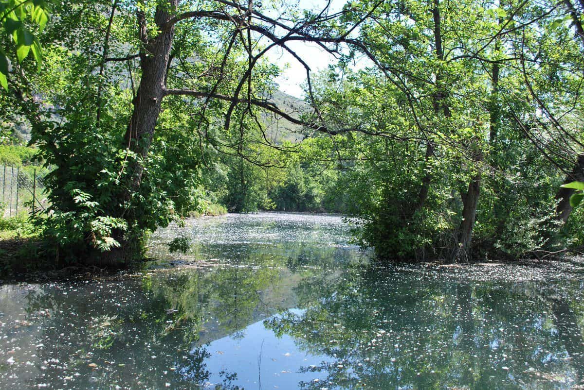
The Mola della Corte, Settecannelle and Capodacqua Natural Monument is a protected natural area in the province of Latina, in the territory of the municipality of Fondi, along the northern edge of the great reclaimed plain that separates the Ausoni Mountains from the sea. It was established in 2001 and the protected area is very small, on the order of four hectares: a size that, read on a regional map, looks almost like a typo next to the tens of thousands of hectares of the Circeo National Park or the Monti Aurunci Nature Park. Yet those four hectares preserve something that has been wiped out across the rest of the plain: a strip of marshy and wooded environment with perennial spring water, a collection basin bounded by ancient walls, a water mill of medieval origin and a population of aquatic plants that elsewhere in southern Lazio is by now reduced to a few surviving stations. The address is Via Mola della Corte 34 D, 04022 Fondi (LT), admission is free and management falls to the Monti Aurunci Park Authority, which also organizes guided visits by reservation. Anyone who arrives here expecting an equipped park with a bar, shaded parking and a two-hour loop trail will be thrown. Anyone who arrives knowing they're facing a fragment of pre-reclamation landscape, a biological and hydraulic archive of a few thousand square meters, comes away with the feeling of having understood something about the history of southern Lazio that no museum tells as well.
Where the Mola della Corte is and how you really get there
Geography matters, in this case, more than size does. The protected area sits at the foot of Monte Passignano, on the inner edge of the Fondi plain, in a strip where the limestone mountain meets the valley floor and gives water back at the surface. The whole water system the entry describes depends on this position: the Settecannelle springs, the basin called Lago Genuardo, the canal that carried the water to the mill and the two drainage ditches for the excess water exist because here the limestone of the Ausoni discharges onto the plain a flow that over the centuries has been captured, channeled and put to work.
By car: the roads that lead to Fondi
The natural route from Rome and the north is State Road 7 Via Appia, which goes through Terracina, cuts across the plain and passes a short distance from the center of Fondi. Alternatively you take the A1 motorway, Frosinone exit, then the Frosinone-Latina expressway or the route through Ceprano and Pico toward Lenola, or else the Cassino exit and the descent to Itri through the valley. From Naples and the south the fastest route remains the A1 up to Cassino and then the road toward Formia and Itri, or the Domitiana and the coast road through Gaeta and Sperlonga. Approximate distances, measured from the center of Fondi: about 120 kilometers from Rome, about 20 from Terracina, about 30 from Gaeta, a little over 10 from Sperlonga as the crow flies but almost 20 by road because the Sant'Andrea pass lies in between. None of these numbers is dramatic, but anyone leaving Rome must allow for the fact that the Appia on summer weekends becomes one continuous queue between Terracina and Fondi, and that the coastal stretch toward Sperlonga in July and August clogs up before 10:00.
Once in Fondi, the protected area is reached by following the signs for Via Mola della Corte, on the northern side of the town. The immediate context is agricultural and peri-urban: greenhouses, crops, fruit and vegetable warehouses, narrow roads, scattered houses. Don't expect a monumental entrance. This is the kind of destination for which it's best to set the navigator to the street address and not the name of the area, because the official place names and those of navigation systems rarely coincide when it comes to natural monuments of four hectares.
By train and bus
The reference railway station is Fondi Sperlonga, on the Rome-Naples line via Formia, served by regional trains and some long-distance runs. It is a few kilometers from the center of Fondi, toward the sea, and from the station depart road connections to the town and to Sperlonga. From Rome Termini the trip by regional train takes roughly an hour and a half. With the faster trains you get off at Formia Gaeta and continue by bus. The Lazio intercity public transport service connects Fondi with Terracina, Formia, Itri, Lenola, Campodimele and Sperlonga.
The point to understand, and I say it plainly, is that the last stretch to the protected area is not served by public transport designed for visitors. Anyone arriving by train who wants to see the mill must allow for a taxi from the station or a walk of quite a few minutes along farm roads with no sidewalk. It's not impossible, but it isn't the best way to spend a day. The practical advice: if you come without a car, combine the visit with an organized tour or ask the Park Authority directly how other groups are getting around, because guided visits often leave from an agreed meeting point.
The context: the Fondi plain and its lakes
To understand where you are you need a mental map of the plain. Between the Ausoni Mountains to the north and the dune ridge that closes off toward the Tyrrhenian, a wide depression opens, once occupied by marshes, ponds and hygrophilous woods. Lake Fondi is the main surviving basin, a brackish coastal lake connected to the sea. A little further south are Lake Lungo and Lake San Puoto, two other bodies of water of similar origin. All around, until the 1930s, there extended a mosaic of wetlands that the reclamation drained, regimented and converted to agriculture. Today the Fondi plain is one of the most intensive fruit and vegetable districts in Italy, with the agri-food market sorting enormous quantities of produce every day.
The Mola della Corte is what remains of the earlier landscape. Not a park created on paper, but a remnant that survived because the spring water served the mill and the mill served the community: the productive function protected the environment better than any restriction, for centuries, and only at the end did the restriction arrive to protect what the productive function had left as an inheritance.
What the protected area really is: a fragment of the pre-reclamation plain
The technical definition that accompanies the protected area describes it as an area of considerable natural importance made up of small fragments of the environment of marshes and forests that was once, before the reclamation, present in the Fondi plain. It is a dry formula and needs to be read carefully, because every word weighs. Fragments, plural: not a compact block but separate pieces. Small: four hectares in total, that is a square a little over 200 meters on a side. Marshes and forests: two different environments, still water and damp woodland, which coexist here because the water table surfaces.
An area surrounded, not isolated
The particular feature that strikes those who arrive is the context. The protected area is surrounded by crops, roads and homes. There is no buffer strip, there is no gradual approach through ever wilder countryside. You go from the world of greenhouses and asphalt to the world of spring water within a few meters. This condition has two opposite consequences. On one hand it makes the visit disorienting and instructive: you feel firsthand how little has remained and how narrow the threshold is between conservation and erasure. On the other it makes the area fragile, because a fragment without a buffer zone suffers everything that happens around it, from nutrient inputs to noise, from the fragmentation of animal populations to the pressure of alien plant species.
In our judgment this is the real reason to go. Large and famous protected areas teach beauty. Tiny and besieged protected areas teach scarcity. They are two different lessons, and the second is forgotten less easily.
The three names of the monument
The official name puts together three distinct place names, and each points to a precise thing on the ground. Mola della Corte is the water mill, with its building, its feed canal and its drainage ditches. Mola, in the place names of southern Lazio and Campania, indicates precisely the milling plant, while corte refers to the manorial property the plant belonged to. Settecannelle is the group of springs at the foot of Monte Passignano, so called for the multiplicity of spring points from which the water comes out. The number seven, here as in so many Italian place names, should be read as an indication of abundance rather than an exact count. Capodacqua, finally, is the term that in half of Italy indicates the point where a spring gives rise to a watercourse, the head of the vein.
Three names, three elements, a single system: the spring that is born, the water that is collected and held, the machine that uses it. It's a hydraulic plant read as a landscape, and environmental protection has ended up safeguarding nature and technology together, which in Italy happens more often than people think but is almost never said clearly.
The size and how to read it
Four hectares is very little. For a point of comparison: the Monti Aurunci Nature Park exceeds 19,000 hectares, the Circeo National Park is around 8,000, and even a medium-sized urban historic garden covers areas comparable to those of the Mola della Corte. The point, however, is that the natural monuments of Lazio are born precisely for this: they are the tool with which the Region protects individual specific elements, a cave, a waterfall, a monumental tree, a spring, a patch of relict woodland, without having to build a park authority around them with staff, budget and management plan. The natural monument formula serves to put a restriction on an object, not to govern a territory.

The mill, Lago Genuardo and the Settecannelle spring
The technical core of the protected area is a complete hydraulic system, still legible today in its three parts. It's worth taking it apart piece by piece, because it is rare to find a system like this preserved whole and not reduced to an isolated ruin.
The spring: the Settecannelle spring points
At the base of Monte Passignano the water comes out not from a single eye but from many spring points distributed along the contact between the permeable limestone and the impermeable deposits of the plain. It's the classic mechanism of contact springs: rain that falls on the carbonate reliefs of the Ausoni seeps into the fractures, travels through the subsurface and re-emerges where it meets a layer that doesn't let water through. The flow of these outflows is perennial and the temperature stays fairly constant throughout the year, a condition that explains why aquatic vegetation manages to survive even in the hot months, when everything else on the plain depends on artificial irrigation.
The name Settecannelle describes exactly this: many mouths, not one. Anyone who visits the area with a capable guide is told how in the past the community of Fondi distinguished the individual spring points, each with a different use, from watering animals to washing clothes to the intake for irrigating vegetable gardens. It's a type of practical knowledge that in the countryside of southern Lazio was lost in two generations and that survives almost only in place names.
The basin: the so-called Lago Genuardo
The water from the springs flows into a collection basin called Lago Genuardo. The word lake should be taken with a grain of salt: it's not a natural lake like the one at Fondi, but a body of water bounded by walls built in past centuries with a double function, containment and sedimentation. Containment served to accumulate a volume sufficient to guarantee the mill a regular flow even in low-water hours. Sedimentation served to let the material carried by the water settle on the bottom, so that clean water reached the canal and the wheel.
This is good-quality pre-industrial hydraulic engineering, and whoever observes it without preparation risks seeing only a pond with walls around it. The detail to look for is the wall itself: its height, the way it joins the ground, the points where it was rebuilt. The masonry of these basins tells of centuries of layered maintenance, with patches from different eras recognizable by the mortar and the size of the stone.
A necessary clarification, because it's the question that always comes up: there is no indication that the basin is used for swimming, nor that there are equipped bathing areas. Anyone who imagines a little lake to dive into in summer has another place in mind. Here the water is the object of protection, not a recreational service.
The canal and the mill
Through a canal the waters of the basin arrived with force to power the mill called Mola della Corte, which worked until a few decades ago. Alongside the feed canal you can see the two drainage ditches meant to dispose of the excess water: an overflow system that kept the basin from overtopping when the spring flow exceeded the needs of the millstone.
The structure of the mill dates from the medieval era and has worked for hundreds of years, with a continuity that has few parallels among minor plants in Italy. What you see now, however, looks more modern than the dating would lead you to imagine, and the reason is simple: whenever a part wore out it was replaced with a new one. The mill is an object that renews itself piece by piece while remaining the same object, and this holds for the wheel, the axles, the millstones, the wooden channels, the roofing. Among the oldest elements what remain are above all stone ruins, which constitute the most direct material testimony of the original phases.
It's worth dwelling on this point, because it touches a question that recurs constantly in Italian industrial heritage. A water mill is not a monument in the way a church is: it is a machine, and a machine in operation is maintained by replacing worn components. To expect a plant that was active for centuries to keep its original materials means not having understood what it is. The Mola della Corte preserves the form, the site, the relationship with the water and part of the ancient masonry, and this is already far more than remains of most of the mills of southern Lazio, almost all of them vanished or reduced to farm storerooms.
A curiosity about the Mola Della Corte - Settecannelle - Capodacqua Natural Monument
The curiosity that strikes most people who hear the story of this place concerns the legal dispute. The beauty and intrinsic value of the site made it the object of controversy as early as the 17th century, and the contest did not pit two ordinary private parties: on one side the Princes and Lords who dominated Fondi, on the other the community of Fondi, that is the city universitas, which claimed collective use of the water and the mill. The dispute dragged on for centuries.
The ending, though, is the interesting part. At present the mill, Lago Genuardo and the Settecannelle spring belong to the Lazio Region, and have therefore returned to the use of the community. Anyone with even a passing familiarity with the history of collective property in Italy knows how rare this outcome is: in the vast majority of cases the disputes between communities and lords ended with the victory of private property, the fencing off of civic uses and the erasure of common right. Here, after 400 years, the water has become public again by the least predictable route, namely environmental protection.
It's a curiosity worth telling visitors precisely because it overturns the usual image of the restriction as an imposition. In this case the restriction gave back a good, it took it from no one.
The 17th century in Fondi: why then
The dating of the dispute to the 17th century is not random. Fondi in the 16th and 17th centuries is a city that has lost the rank it had held in the 15th century under the Caetani, when the court of Onorato II had made the city a notable center of artistic patronage. The passage of the fief to the Colonna first and to other houses afterward, together with the demographic crisis that followed the Barbary raids of the 16th century, reduced the population and increased the relative weight of feudal revenues. In that context, a mill perpetually fed by a spring that knows no drought is an asset of extraordinary value: while river mills stop in summer, the spring mill works all year. Control of such a plant equaled, in modern terms, control of a power station in a territory without a grid.
This is the economic motive of the dispute, and it explains why four hectares generated court papers for generations.
The vegetation: hornwort, vallisneria and the damp woodland
The site, though it has undergone profound transformations, represents a residual strip of the vegetation of wetland environments, and precisely as a residual strip it works as a refuge for species that elsewhere have been thinned almost to disappearance.
The two rare species of the water
Significant is the presence of two very rare aquatic plants considered at risk of extinction: hornwort and vallisneria. It's worth spending a few lines on both, because they are inconspicuous organisms and the distracted visitor risks passing over them without noticing.
Hornwort is an entirely submerged plant, without true roots, which floats in the water column held up by branching stems with leaves arranged in whorls and divided into thin, rigid segments, from which the name that points to the horn-shaped leaf. It lives in still or very slow-moving waters, rich in nutrients but clear, and its presence indicates a body of water that has suffered neither drying out nor chronic turbidity. In Italian waters the genus has undergone a drastic contraction with the reclamation of wetlands and with eutrophication.
Vallisneria, by contrast, is a plant rooted on the bottom, with long ribbon-like leaves that stretch out in the current and a pollination system among the most spectacular in the aquatic plant world: the male flowers detach from the plant and rise to the surface, where they float until they meet the female flowers carried up high by a long spiral stalk. After pollination the stalk coils back up, dragging the fruit underwater. Anyone with an aquarium knows this plant because it is among the most widespread in the aquarium trade, and here it finds one of its surviving spontaneous stations.
The joint presence of these two species in a body of water of a few hundred square meters, surrounded by intensive agriculture, is the real reason the site obtained protection. Not the beauty, not the mill: two plants that nobody notices.
Riparian vegetation and the hygrophilous woodland
Around the water develops the band of vegetation that ecologists call riparian. In the wetlands of southern Lazio the typical composition includes black alder, willows of different species, poplars, southern ash, with an understory of reeds, sedges, rushes and ferns. At the wooded margin there also appear species of the lowland oak woodland, that is the plain woodland that covered the plain before the reclamation and that today in Lazio survives almost only in the state forest of the Circeo and in very few other fragments.
The concrete threats
A protected area of four hectares surrounded by intensive crops lives under constant pressure. The main risk factors are known and it's worth stating them frankly: the input of nutrients from the surrounding farmland, which favors algal proliferation and reduces water transparency to the detriment of submerged plants, the pumping of the water table for irrigation, which can reduce the spring flow, the arrival of alien plant and animal species, which in Italian aquatic environments has caused enormous damage, and fragmentation, which prevents genetic exchange with other populations.
I say openly what I think: a site like this is not defended with a restriction sign. It's defended by controlling what happens in the surrounding fields and in the water table below, that is with tools that sit outside the protected perimeter. It's the structural limit of the natural monument formula, and it's also the reason why collaboration with the Monti Aurunci Park Authority makes sense: an authority with a large territory behind it can do what a point restriction can't do on its own.
Something nobody tells you about the Mola Della Corte - Settecannelle - Capodacqua Natural Monument
What nobody says is that the value of this place isn't understood by looking at the place, but by looking at what surrounds it. If you arrive, park, go in, photograph the mill and leave, you will have seen a rural building next to a pond. The meaning appears only if, before or after, you drive 20 minutes into the plain and observe the straight reclamation canals, the greenhouses, the regular rows, the straightened ditches, the geometric lattice that replaced the disorder of the marsh.
The Fondi plain is one of the great works of territorial transformation of 20th-century Italy, on a par with the Agro Pontino. It produced real wealth, eliminated malaria, created one of the most important fruit and vegetable hubs in the country. It also erased an entire ecosystem. Both things are true together and anyone who tells only one of them is oversimplifying.
The Mola della Corte is the control sample of the experiment: the piece left as it was, which lets you measure the difference. And that is why the visit makes most sense for those who have already seen the rest. The operational recommendation is not to start the day here but to end it here, after crossing the plain and perhaps after going up the Aurunci to look at it from above. In that order the message gets through. In the reverse order you're left with a pleasant hour or so and nothing more.
The other thing rarely said: the scale of time
There is a second element that usually goes unmentioned. The mill worked from the Middle Ages until a few decades ago: this means that the end of activity is very recent, and that there are still people in Fondi who remember the plant running, the noise of the wheel, the comings and goings of the carts. This isn't remote archaeology but living memory, and the best way to visit the Mola della Corte remains to listen to someone local. The Park Authority's guides collect and relay these testimonies, which are the most perishable part of the entire heritage of the site: the stones endure, the stories don't.
The advice I give you for visiting the Mola Della Corte - Settecannelle - Capodacqua Natural Monument
The main advice is one and I put it first: book the guided visit and don't show up at random. The available information indicates free admission and an opening spread over morning hours on weekdays, with an afternoon return on two days of the week, but the hours of minor protected areas change with the season, with staff availability and with the conditions of the site. The Park Authority's number and contacts are on the contact page of the Monti Aurunci Park Authority, and that's where it's best to start to arrange the guided visit and get the actual days and hours confirmed before getting in the car.
What to wear and bring
This is a damp lowland environment, and that determines everything. Closed shoes with soles that grip mud, even in summer. Long pants, because riparian vegetation scratches and because mosquitoes in a wetland are not a possibility but a certainty. Repellent, to apply before getting out of the car and not after the first bite. Water, because there are no refreshment points reported inside the area. A light pair of binoculars changes the visit completely, because much of what there is to see moves among the branches or on the water at a distance. Anyone interested in aquatic botany should make room in the bag for a 10x magnifying lens: hornwort and vallisneria can only be appreciated up close.
How much time you need
On its own, the protected area takes from 45 minutes to an hour and a half, depending on how long you stand listening. It's worth building half a day around it by adding the historic center of Fondi, which deserves it on its own with the baronial castle, the Giudea quarter and the urban layout of Roman origin still legible in the grid of the streets. Anyone with a whole day adds Lake Fondi and then the sea, or the climb toward the Aurunci Mountains and the inland villages.
With children
It works, but on one condition: that someone tells the story. The water mill is one of the most effective teaching objects that exist, because it shows in a visible and understandable way how the movement of water is turned into work. An eight-year-old child understands the principle in five minutes and remembers it for 20 years. Left alone in front of a fenced pond, instead, they get bored in three. Booking the guided visit, when there are children, is not optional.
Accessibility
On this point I prefer to be cautious rather than reassuring. There is no detailed and reliable public information on the internal paths, the slopes, the surfaces and the presence of accessible restrooms. Anyone with specific mobility needs should put the question directly to the Park Authority when booking, describing their own situation: it's the only way to get a useful answer instead of a generic promise.

The fauna, the birds and the relationship with Lake Fondi
Together with nearby Lake Fondi, today included in the protection system of the Monti Ausoni Regional Park, the area of the Mola della Corte hosts a biodiversity that is surprising for the surface involved. The ecological concept to keep in mind is that of a network: an isolated fragment loses species quickly, a fragment connected to other wetlands loses far fewer. The Fondi plain, though transformed, still preserves a necklace of wetlands made up of Lake Fondi, Lake Lungo, Lake San Puoto, the reclamation canals and this small spring node. For a heron, a coot, an amphibian, that necklace is a single system.
Birds
The wetlands of the Fondi plain lie on an important migratory route along the Tyrrhenian coast, and this means the list of observable birds changes radically between March and April, between September and November, and in the winter months. In wet environments of this kind you commonly see gray herons, little egrets, night herons at twilight, moorhens and coots, kingfishers along the canals with clear water, reed warblers and Cetti's warblers in the reed bed, gray wagtails on the edges of the tanks. In the damp woodland there are woodpeckers, tits, blackcaps, and in winter finches in flocks.
I don't want to pass off as certainty what depends on season and luck: here we're talking about suitable habitats, not guaranteed sightings. Anyone who wants to do serious birdwatching in the area should use Lake Fondi as a base, where the open waters allow observation at a distance, and use the Mola della Corte as a complementary stop for the species tied to woodland and running water.
Amphibians and invertebrates
Perennial spring environments are fundamental for amphibians, which need permanent or at least lasting water to complete larval development. In southern Lazio the thinning out of amphibians is one of the most marked phenomena of recent decades, and small sites like this work as reservoirs. Aquatic invertebrates, from dragonflies to beetles, are equally indicative: the presence of dragonfly species tied to clean, well-oxygenated waters is one of the most immediate signs of the quality of a body of water, and anyone visiting the area in June or July notices it without needing specialist skills.
The role of the Monti Ausoni Regional Park
The reference to the Monti Ausoni Regional Park, which includes Lake Fondi, should be read as a system fact. Different protection instruments have layered up around the plain over time, with distinct perimeters, bodies and purposes, and the overlap can confuse the visitor. To summarize the responsibilities: the Mola della Corte natural monument protects the spring point with the mill. The system of regional parks protects Lake Fondi and the hill belts of the Ausoni. The Monti Aurunci Nature Park protects the massif to the east. The Circeo National Park protects the promontory, the dune, the lowland forest and the coastal lakes to the west. Four different instruments for a single, historically unified landscape.
Another well-known fact, yet seldom mentioned
The well-known fact is that the Fondi plain was marshy and malarial. Everyone knows it, it is repeated in every description, and for that very reason no one reflects on it anymore. What is almost never said is the precise economic and social consequence of that condition: the marsh wasn't a void, it was a resource. Before the reclamation the plain produced fishing, hunting, reed, rush, timber, winter pasture, and supported a population that lived on activities now gone. The reclamation did not simply replace nothing with agriculture: it replaced one economy with another, and shifted wealth from some social groups to others.
The water mills fit into this picture. A mill fed by a perennial spring, in a territory where surface waters were abundant but stagnant and therefore unusable for motive power, represented a point of concentration of value. That is why the centuries-old dispute, that is why the containment walls built and rebuilt for generations, that is why the place name preserves the reference to the manorial court.
There is then a second rarely cited fact, of a hydrogeological nature. The springs at the foot of the Ausoni and the Aurunci depend on a recharge basin that extends much farther upstream than the visitor imagines: the rain that falls on the high elevations of the massif takes months to cross the karst system and re-emerge on the plain. It means that today's flow at Settecannelle tells the climate of yesterday, and that variations in rainfall on the reliefs reach the springs with a delay. Anyone who deals with water management in this area knows it well. Those who visit the area usually don't, and it would be useful if they did, because it makes evident that protecting four hectares on the plain means, in fact, depending on what happens on several thousand hectares of mountain.
The right photo to take at the Mola Della Corte - Settecannelle - Capodacqua Natural Monument
The wrong photo is the one everyone takes: the mill head on, in full sun, at 11 in the morning, with the sky blown out and the water reduced to a white slab. You get an anonymous postcard that conveys nothing of what you have just seen.
The photo I recommend
The image that truly conveys the place is the one that puts three planes together: the water in the foreground, the masonry of the basin or canal in the middle ground, the damp vegetation closing the background. It's a composition that tells the system as a whole, which is exactly the reason the site is protected. To get it you need a low position, almost at the water's surface, and a horizontal frame.
The right light is that of the early morning hours or late afternoon, when the raking sun picks out the texture of the stone and the water stops behaving like a mirror. On overcast days, which in a wetland happen often, you get the best results of all: the white sky works as a giant diffuser, the greens saturate and the unmanageable contrasts between deep shadow and reflection disappear. If you own a polarizing filter, here you really need it: by rotating it you decide how much reflective surface to keep and how much submerged vegetation to let show beneath the water's skin. It's the tool that lets you photograph hornwort and vallisneria where they really are, that is below the surface.
Common-sense rules
No drones without authorization, and in a protected area authorization must be requested beforehand and in writing. No going into the water to look for the best angle: submerged vegetation is the very object of protection and is destroyed in an instant. No removing branches or leaves to clear the frame. If the context doesn't allow you the photo you had in mind, come back with different light instead of changing the place.
Some important events that happened here in history
The history of this corner of the Fondi plain can be ordered by phases, and each has left a mark legible on the ground.
The Roman age and the roads
Fondi was born as a Volscian center and became a Roman municipium with the name Fundi, crossed by Via Appia, which here runs flat before climbing toward the Itri pass. The grid-like urban layout of the historic center still preserves the trace of that phase, and it's one of the most legible cases in southern Lazio. In Roman times the plain was already partly exploited, with drainage systems and quality viticulture: Caecuban wine, produced in this coastal strip between Fondi and Sperlonga, was celebrated by Latin authors among the best in Italy, and Horace cites it as a wine for important occasions. The link with water is direct: where there is a perennial spring there is stable settlement, and the spring points at the foot of the Passignano were known and used long before the mill existed.
The Middle Ages and the building of the mill
The milling structure is of medieval layout. In this phase the plain passes under the control of manorial powers that organize the exploitation of the waters: milling becomes a reserved right, peasants are required to grind at the lord's mill, and the plant generates a stable income. The building of the basin's containment walls belongs to this long-term logic, with later rebuildings over the centuries.
The 15th century of the Caetani and the 16th century of the raids
Fondi experiences in the 15th century a season of splendor under the Caetani, with Onorato II making the city a center of court and patronage. In 1534 the city suffers the raid of the Ottoman fleet led by Khayr al Din, the corsair known in the West as Barbarossa, an episode tied in tradition to the attempt to kidnap Giulia Gonzaga, lady of Fondi. The assault causes destruction and contributes to the long demographic crisis of the city. The productive plants of the plain, mills included, feel the effects of this phase of contraction.
The 17th century and the property disputes
This is the phase documented by the papers of the dispute: from 1600 onward the site is the object of controversies between the Princes and Lords dominant in Fondi and the community of Fondi, each side claiming title to the area, the water and the plant. The contest runs through generations and intertwines with the more general question of civic uses in the Kingdom of Naples.
The 20th century: the reclamation and the end of milling
In the 1930s the great reclamation radically transforms the plain, draining the marshes, straightening the ditches, building the lattice of canals and opening the way to the intensive agriculture that still characterizes the territory today. The pre-reclamation landscape disappears almost everywhere. The mill continues to work for decades more, until stopping for good in relatively recent times, overtaken by industrial milling.
2001 and protection
The last event in chronological order is the establishment of the natural monument, which took place in 2001 by measure of the Lazio Region. With it the mill, the basin and the spring pass into public availability and return to the use of the community, closing by administrative means a question opened four centuries earlier.
Who has passed through the Mola Della Corte - Settecannelle - Capodacqua Natural Monument
For a site of this kind the question has to be posed correctly. This isn't a palace with a register of illustrious guests: it's a country mill. The people who really passed through here, for centuries, are the peasants of the plain with their carts of grain, the millers who lived off the plant, the feudal administrators who collected its proceeds, the surveyors and notaries commissioned to measure, describe and contest the property during the disputes. These are the figures who wore down the threshold of the Mola della Corte, and it's right to name them first.
Historical figures tied to the territory
That said, the history of Fondi lines up names that marked southern Lazio and that belong to the context in which the mill operated. Onorato II Caetani, lord of Fondi in the 15th century, built a notable court around the city and promoted the artistic activity still recognizable in the churches of the center. Giulia Gonzaga, lady of Fondi in the first half of the 16th century, is the best-known figure tied to the city: a cultured woman, at the center of a circle of religious reformers, protagonist of the 1534 episode with Barbarossa's fleet. In the 17th and 18th centuries there follow in succession the houses that contend for rights over the waters and mills of the plain, and it is their administrators who produce the documentation of the dispute.
Who passes through today
Today three categories of people mainly pass through here, and it's worth recognizing them because they define the character of the place. The school groups of the area, whom the Park Authority accompanies on environmental education routes and for whom the mill works as a physics and history lab at once. The naturalists and botanists, drawn by the hornwort and vallisneria stations and by the value of the site as a relict fragment. The curious travelers who have already seen Sperlonga, Terracina and the Circeo and are looking for something that doesn't appear in the first 20 pages of the guidebooks.
The big tourist flows do not pass through here, and that's a good thing. A four-hectare site with rare aquatic vegetation wouldn't withstand high numbers. The formula of the guided visit by reservation, which to some looks like an obstacle, is actually the reason there is still something to see.
When to go and when to avoid the visit
Seasonality in a lowland wetland is a decisive factor, much more than at an archaeological site or in a historic center.
Spring: the best period
Between April and June everything that makes the place interesting is concentrated. The riparian vegetation is at the height of growth, the aquatic plants are well developed and visible, amphibians are active, dragonflies begin to fly, migratory birds pass through and nesting ones sing. Temperatures are pleasant and the mosquitoes, though present, haven't yet reached the August level. If I had to indicate two weeks, I'd say the second half of May.
Autumn: the second choice
From mid-September to the end of October the site is still excellent. The light becomes warmer and lower, and for photography it's the best period by far. The autumn migratory passage brings different species from spring. Mosquitoes decline. The flip side is that the vegetation begins to yellow and the aquatic plants are less conspicuous.
Summer: possible but tiring
July and August on the Fondi plain mean humid heat, mugginess, insects and traffic on the Appia and on the coast. The visit remains feasible in the early morning hours, which moreover coincide with the most likely opening window, but comfort drops considerably. Anyone in the area in August for the sea who wants to devote an hour to the mill should make the stop at eight 30 and not at noon.
Winter: for few
In the cold months the site loses the plant component and gains the hydrological one: the springs are at maximum flow, the water is very clear, the bare woods let you see the masonry structures better than in any other season. For anyone interested in hydraulic archaeology it is perhaps the most instructive moment. For anyone seeking lush nature, the least suitable. The ground can be muddy and the days are short.
When to avoid
To be avoided, quite simply, the days following heavy rain: the routes in a wet environment become impassable and the turbid water cancels the very observation that makes the visit worthwhile. Also to be avoided are days when you don't have a confirmed reservation, because a minor protected area does not guarantee free, staffed access at every moment.
What's around: the plain, the Aurunci and the Riviera di Ulisse
The Mola della Corte works well as a piece of a broader itinerary, and the area offers quite a few.
Fondi and its historic center
The center of Fondi deserves a walk of at least an hour and a half. The street layout preserves the Roman grid, the baronial castle with its cylindrical tower dominates the main square, the church of San Pietro holds notable works, and the Giudea quarter bears witness to the presence of a Jewish community documented in the Middle Ages. The contrast between the walled city and the surrounding agricultural plain is one of the sharpest in southern Lazio.
The mountains: Aurunci, Ausoni and the inland villages
To the east and north rises the limestone barrier. The Monti Aurunci Nature Park offers trails, high-altitude pastures, refuges and panoramas that reach from the Circeo to the Pontine islands as far as the Gulf of Gaeta. Anyone who wants a quick overview of the massif will find a general framing on the page dedicated to the Aurunci Mountains. Among the villages, Campodimele is known for the longevity of its inhabitants and for its perfectly preserved medieval walls. Lenola looks out over the valley with the sanctuary of the Colle. Itri keeps the castle and the medieval village perched on the old Appia.
The sea: the Riviera di Ulisse
To the south opens one of the most beautiful stretches of coast in Lazio. The Riviera di Ulisse includes the shoreline between Sperlonga, Gaeta and Formia, with caves, Roman villas and coves. Sperlonga is the white village perched above the sea with the villa of Tiberius and the archaeological museum. Gaeta combines the medieval village, the split mountain and the beaches of Serapo. Toward the north the beach of Terracina introduces the Circeo promontory and the lowland forest of the Circeo National Park, which is the natural benchmark for understanding what the plain was before the reclamation.
The caves and the inland mountains
Anyone who wants to stay on the theme of water and karst will find a little further north, in the province of Frosinone, the Falvaterra Caves and Rio Obaco, an active underground system traversed by running water that perfectly completes the hydrogeological reading begun at Settecannelle: there you see where the water runs under the mountain, here you see where it re-emerges on the plain.
Quick questions about the Mola della Corte
Can you swim in the little lake?
No bathing area or area equipped for swimming is reported. The basin is an element of the protection, not a recreational service, and the rare aquatic vegetation it hosts is exactly what bathing would destroy.
Is admission paid?
The available information indicates free admission. Guided visits may follow different arrangements and must be agreed with the Park Authority.
How long does the visit last?
From three quarters of an hour to an hour and a half, depending on the level of depth. It's best to fit it into half a day that also includes Fondi or the coast.
Do you need to book?
For the guided visit yes, and it's best to do it even just to confirm the actual days and hours, which in minor protected areas change with the season and staff availability.
Are there services, bars, picnic areas?
No refreshment services are reported inside the protected area. Water and a snack are brought from home, and lunch is had in Fondi or along the coast.
Can you still see the mill working?
The plant ceased operating a few decades ago. What you see is the structure with its feed system, not a millstone in motion.
Are there mosquitoes?
In a lowland wetland in southern Lazio, yes. Repellent and long pants from April to October.
Can you get there without a car?
With difficulty. Fondi Sperlonga station is a few kilometers away and the last stretch is not served by connections designed for visitors. Anyone traveling without their own vehicle should arrange in advance with the Park Authority or with a tour guide.
The final verdict, for those who have made it this far: the Mola della Corte doesn't compete with the Circeo, with Sperlonga or with Gaeta on the level of spectacle, and anyone who sets it against them will be disappointed. It competes on a different ground, that of density of meaning per square meter, and on that ground few places in southern Lazio hold up to the comparison. Four hectares that contain a karst spring, a hydraulic work centuries old, a medieval machine, two plants at risk of extinction and a lawsuit 400 years long ended with the return of the asset to the community. Nothing more is needed to justify an hour's detour.
Frequently asked questions about the Mola Della Corte, Settecannelle, Capodacqua Natural Monument
Can you swim in the little lake at the Mola della Corte?
No, no bathing area or area equipped for swimming is reported at the Mola della Corte. The basin is an element of the protection, not a recreational service, and the rare aquatic vegetation it hosts is exactly what bathing would destroy.
Is admission to the Mola della Corte Natural Monument paid?
The available information indicates free admission to the Mola della Corte Natural Monument. Guided visits may follow different arrangements and must be agreed with the managing body, so it's best to check hours and conditions before leaving.
Where is the Mola della Corte, Settecannelle, Capodacqua?
The protected area sits at the foot of Monte Passignano, on the inner edge of the Fondi plain, in a strip where the limestone mountain meets the valley floor and gives water back at the surface, feeding the Settecannelle springs and the basin called Lago Genuardo.
What is inside the Mola della Corte protected area?
The protected area encloses a complete hydraulic system: the Settecannelle springs, with many spring points at the base of Monte Passignano, the basin of Lago Genuardo and the mill, a rare example of a system of this kind preserved whole and not reduced to an isolated ruin.
When is the best time to visit the Mola della Corte?
Spring is the best period for the Mola della Corte: between April and June the riparian vegetation is at the height of growth, the aquatic plants are well developed and visible, amphibians are active and dragonflies begin to fly.
Should you book the visit to the Mola della Corte?
Yes, the main advice is to book the guided visit to the Mola della Corte and not show up at random. The available information indicates morning hours on weekdays with an afternoon return on two days of the week, but the hours of minor protected areas change with the season.
Are there rare species to see at the Mola della Corte?
Yes, the site has two very rare aquatic plants considered at risk of extinction, hornwort and vallisneria, which survive in this residual strip of the wetland vegetation of the Fondi plain.
Article written by the editorial team of TourLeaderPro, contact them for Private/Corporate/V.I.P. Tours and Experiences. For a day organized among the Fondi plain, the Aurunci and the Riviera di Ulisse, with a licensed tour guide, start from the TourLeaderPro contact page. Tour operators building itineraries in southern Lazio will instead find the consulting service in the section dedicated to tour operators.
Are you planning a trip to Italy? The English guides for organizing your stay are on ItalyPlanner.com. For those thinking in terms of days out of town there is the guide to the best day trips from Rome, useful for understanding how to fit southern Lazio into a trip based in the capital.