La Portella di Trevi nel Lazio
In short. La Portella di Trevi nel Lazio is the pass, the trail and the wayside shrine you reach from the Roman bridge of San Teodoro, on the Provincial Road that follows the Aniene upstream at Trevi nel Lazio (FR), inside the Simbruini Mountains Regional Natural Park.
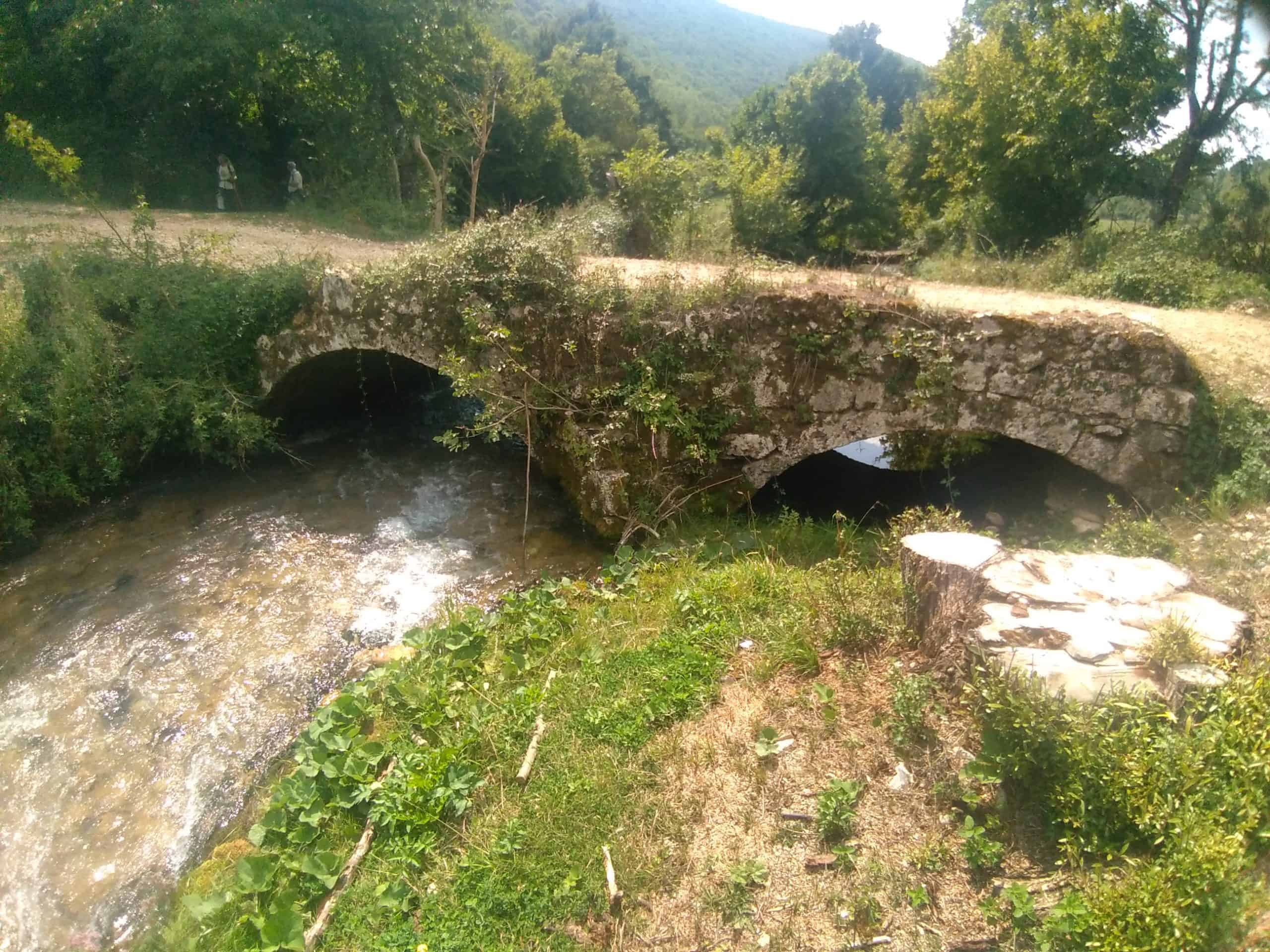
La Portella di Trevi nel Lazio is the pass, the trail and the wayside shrine you reach from the Roman bridge of San Teodoro, on the Provincial Road that follows the Aniene upstream at Trevi nel Lazio (FR), inside the Simbruini Mountains Regional Natural Park. Access to the trail is free, with no ticket, no opening hours and no booking: the trail marker is the Park's 692c, 6.4 kilometers long up to Regional Road 411, with a minimum elevation of 689 meters, a maximum elevation of 974 meters, 380 meters of elevation gain and 127 of descent, difficulty T (tourist) and a walking time given by the Park as 1 hour and 50 minutes for the whole route. The shrine of the Madonna della Portella is reached much earlier, in less than half an hour's walk from the bridge. From Rome it takes about an hour and a half by car via the A24 and Vicovaro Mandela, then the Tiburtina Valeria and the Aniene valley toward Subiaco. By bus, take the Cotral from Ponte Mammolo to Subiaco and from there the connection to Trevi nel Lazio, with sparse runs on holidays. The information point on site is the Park Visitor Center in Trevi nel Lazio, on via E. Germani, open to the public Monday to Friday from 9:00 to 13:30, phone 0774 827221, email promozione.sviluppo@simbruini.it.
The town that gives the place its name, the Caetani castle and the Collegiata are covered on the page dedicated to Trevi nel Lazio. Here we talk about the gorge, the trail and what you meet on the way up. The reference protected area is that of the Simbruini Mountains, and the river corridor that runs through it is that of the Aniene valley.
La Portella remains the most honest way into the Simbruini. It doesn't ask for training, it doesn't ask for technical equipment, it doesn't ask for a whole day. It asks for a pair of shoes that hold on wet limestone and the willingness to walk uphill for 25 minutes without looking at your phone.
Where La Portella di Trevi nel Lazio is
Trevi nel Lazio sits at 821 meters above sea level, in the highest part of the Aniene valley, in the province of Frosinone, on a municipal territory of 54 square kilometers inhabited by fewer than 2,000 people. The town occupies Colle Clemente, surrounded by the Simbruini to the north, the Cantari to the east and the Ernici to the south. La Portella is not in the built-up area: it is below the town, on the valley floor, where the provincial road meets the Aniene and crosses it with a stone bridge.
The exact point where the Portella trail starts
Kilometer zero is the San Teodoro bridge, downstream from the village. If you come from Subiaco you meet it on the right, just before the climb to the town. If you come down from Trevi you find it at the bottom of the hairpins. There is no ticket office, no gate, no opening time: there is a bridge, a sign of the Simbruini Mountains Park and a mule track that starts right after the crossing, on the right. The white and red trail marker carries the number 692c. That mule track is the only thing you need to know to find your way: from there on the route is a single one up to the shrine.
How to get to La Portella di Trevi nel Lazio by car
From Rome you take the A24 toward L'Aquila, exit at Vicovaro Mandela and take the Tiburtina Valeria toward Subiaco. Past Subiaco, the road follows the Aniene upstream toward Comunacque and then toward Trevi nel Lazio: about 90 minutes from the Grande Raccordo Anulare in normal conditions, longer on summer weekends, when the valley fills up. The inland alternative goes through the Arcinazzo plateaus and comes down to Trevi from Regional Road 411: longer, much more beautiful, and it has the advantage of letting you meet the Arco di Trevi before the trail rather than after.
How to get to La Portella di Trevi nel Lazio by public transport
The connection is regional, by road: from the Ponte Mammolo metro station the Cotral buses leave for Subiaco, terminus in piazza Falcone, and from Subiaco you continue with the local runs for the upper valley. The frequencies are designed for residents, not for hikers: few runs, concentrated in the early morning and late afternoon, reduced to the minimum on Sundays and holidays. Schedules need to be checked on the carrier's official website before leaving, because they change with the school calendar. My advice, without beating around the bush: for La Portella the car is the sensible choice, and if you haven't got one, consider an organized outing by the Park.
Where to park at La Portella
You leave the car in the pull-offs along the provincial road, near the bridge. There are few spots, unmarked, and on weekends in May and October they fill up by 10 in the morning. Whoever arrives late ends up parking along the road, on a curve, where farm vehicles pass daily: it's the most effective way to ruin your day. Better to go up to the town, leave the car in the parking lots in the center and walk down, adding 20 minutes on the way out and a climb on the way back.
What La Portella di Trevi nel Lazio really is
The word portella, in Apennine vocabulary, means a small door, a narrow gap between two rises, the point where a slope lets itself be crossed. It's not a poetic name: it's a technical name, the kind shepherds and carters used to say where you pass. At La Portella di Trevi the definition is literal, because the place is both a natural pass and a built door: the wayside shrine you meet along the trail has the shape of an arch you walk under, and whoever climbs really goes through it, not looks at it from outside.
A door, a pass, a name
From the shrine the eye falls on the Portella della Civita district, the high and ancient part of Trevi, the one built around the fortress. The coincidence of the names is the strongest toponymic clue we have: the gap and the district that looks at it have the same name, and the derivation of one from the other is the most economical explanation. It remains a reasonable hypothesis, not a documented fact, and whoever tells you otherwise is selling certainties that no paper holds.
The route is older than the name
The mule track that climbs to La Portella follows what has historically been the only road to reach the settlement of Treba, the Aequi settlement that the Romans absorbed and renamed Treba Augusta. The route is of pre-Roman origin and linked the Aniene valley floor to the villages of the Ernici Mountains, crossing the watershed. Put another way: for centuries, anyone who wanted to go from Trevi to Guarcino on foot passed through here, and had no alternative. The trail was not built for hikers, hikers inherited a road.
The Roman bridge of San Teodoro, the threshold of La Portella
The walk begins on a structure that is worth the detour by itself. The San Teodoro bridge, which crosses the Aniene at the foot of Trevi, is most probably one of the last Roman-built bridges to have survived time and the countless floods of the river in this valley. It's not a fenced-off ruin: it's a structure in use, which still carries traffic, and which you cross on foot.
Why the bridge is still standing
The Aniene, in this upper stretch, is a nervous river. It is fed by karst springs that discharge, in a few hours, amounts of water out of proportion to the average flow, and the hydraulic history of the valley is a history of bridges swept away. That this one has remained depends on its geometry: a stone arch, a span sized on the gorge, abutments resting on living rock rather than on alluvial deposits. It's ancient engineering that understood the river better than many 19th-century works built 30 kilometers downstream.
The Aniene under the bridge
Lean over the parapet before taking the trail. In this stretch the water is still very close to its springs and runs clear, with that cold green color that limestone gives Apennine rivers. Further downstream, toward Comunacque, the Aniene meets the Simbrivio and changes character. Here it is still young and noisy, and the noise accompanies you for the first quarter of an hour of the climb, then suddenly dies away when the mule track leaves the bank. That silence arriving all at once is the thing you remember most.

Trail 692c, the complete route of La Portella di Trevi nel Lazio
692c is the number to look for on the signs and on the tree bark. It's the trail that links the San Teodoro bridge to the Arco di Trevi, passing by the Portella shrine and the Capo d'Acqua watering trough, and the trail network of the Simbruini Mountains Park classifies it as tourist, the easiest category of the Italian hiking scale. Tourist doesn't mean paved: it means there are no exposed passages, that the ground is always readable and that you need no equipment beyond the right shoes.
The numbers of trail 692c
Length 6.4 kilometers. Minimum elevation 689 meters, at the bridge. Maximum elevation 974 meters, near the Arco. Elevation gain 380 meters, descent 127. Time given by the Park for the whole route: 1 hour and 50 minutes, which is reasonable for someone walking at a steady pace and not stopping to photograph every beech. With stops, lunch and a return on the same route, the day fills up comfortably. Whoever wants only the shrine walks less than 30 minutes uphill and as much downhill.
First stretch, from the bridge to the coppice woods
After crossing the bridge over the Aniene you climb the wide mule track on the right, which enters the coppice woods right away. The surface is packed earth and rubble, with a few natural steps where rainwater has dug in. The slope is modest and constant. The woods shade almost the whole stretch, which in July makes the difference between a walk and a penance. Whoever walks in silence, in the early hours, has a good chance of seeing something move among the coppices: the Simbruini are ungulate and raptor territory, and the valley floor is their corridor.
The hairpins on Monte Malemito
The mule track gains elevation with a series of hairpins that cut across Monte Malemito, the rise that separates the valley floor from the pass. It's the stretch where you work, and it is short. The route is the old one, wide enough to let a loaded mule pass, and in several places you can recognize the dry stone retaining walls of the roadbed. Look at them: they are the reason a pre-Roman road still exists. Every generation of Trevi people has put them back in place, quietly, to keep being able to pass.
Arriving at the shrine of Santa Maria della Portella
After the hairpins the mule track reaches the arch with the shrine. It's the moment when the route stops being a climb and becomes a place. The arch is imposing and clearly visible from the pass, and you walk through it: the trail goes under the vault, and the act of going under it is exactly what shepherds, pilgrims, soldiers and wayfarers have done for centuries. Here most people stop, and they're right to: it's the viewpoint over the town and the valley, and it's also the only point on the route where it's worth sitting and not talking for five minutes.
From La Portella to the Capo d'Acqua watering trough
Those who continue find a route of a completely different character. The mule track bends toward the southeast, leaves the woods, crosses a stretch of gentle slope and descends to the Capo d'Acqua watering trough. It's the panoramic part of the 692c, the one where you see the outline of the Ernici Mountains on the opposite side and understand why this was a road and not a whim. The watering trough is an ancient landmark of transhumance: water was the reason the route passed there and not 300 meters higher up.
From the watering trough to the Arco di Trevi
Past the ditch, the trail climbs steeply through grassy areas, runs alongside the stream and reaches the Arco di Trevi, then joins Regional Road 411 between Guarcino and the Arcinazzo plateaus. This is the most tiring section of the whole route, concentrated in the last kilometers, when your legs have already worked. Whoever arrives with the air of someone who has taken a Sunday stroll changes expression here. Bring enough water: the watering trough is not a guaranteed refill point and should be considered uncontrolled water.
Variants and the return
The 692c is not a loop. Whoever walks all of it has to organize the return: either you go back on the same route, and that's another six kilometers with the elevation reversed, or you leave two cars, one at the bridge and one on the 411 near the Arco, which is the most practical solution for mixed groups. The Park network offers other numbers around Trevi, from 692b onward, that allow loop combinations: they need to be studied on the Park map before leaving, not improvised on the spot following the trail marks you come across.
The shrine of Santa Maria della Portella
The monument everything revolves around is a wayside shrine built in the shape of an arch, expanded into a chapel in the 19th century. Its position is not only devotional: the arch, imposing and clearly visible at the pass, stands at the point where ancient Treba could be taken from behind, and local tradition links it to the protection of the town from attackers coming up the valley. A sign of faith guarding a military gap: in the central Apennines it's a combination so frequent as to be almost a rule.
What you see today under the arch
Under the vault is the sacred image, a terracotta that replaced an earlier depiction lost through exposure to the elements. It is the last link in a chain of images that have followed one another in the same spot, each destroyed by the weather and replaced by the community. The structure looks well kept, particularly in spring, when maintenance comes before the pilgrimage season. On the entrance door and on the walls you can read inscriptions: they are the source from which local memory has reconstructed a large part of the place's story.
Giovan Battista Ciolli, the crayfish and the horse
Trevi tradition attributes the 19th-century remaking of the shrine to a certain Giovan Battista Ciolli, whose name would appear on the structure together with two figures, a marsh crayfish and a horse. The story handed down in town describes him as a farm laborer from Trevi who emigrated to work in the Pontine plain, then marshland, in the service of a bullying master. Tired of the abuse, he would have returned to Trevi bringing with him some animals as payment for unpaid work. The master would have chased him as far as the town without finding him, because Ciolli had taken refuge with the animals on Monte Malemito, the very one the trail crosses. The crayfish would stand for the Pontine marsh, the horse for the pursuing lord.
Let me be clear: this is oral tradition, not an archive document. I tell it because it is alive, because it explains two images that would otherwise be incomprehensible and because it shows what bond ties the Trevi people to this pass. I don't tell it as established history. Whoever wants to verify it has to go read the inscriptions on site, and then look for confirmation in the parish and municipal archives, which is work that no guide can do in your place.
From the Madonna del Riposo to the terracotta by Elio Marra
Local memory connects the Portella shrine to the devotion to the Madonna del Riposo, to whom a chapel built in 1483 is also dedicated in Trevi, and tells of a mural fresco of the Madonna del Riposo made on the occasion of the expansion and lost to the weather, later replaced by a painting of Mary Help of Christians. The present image, in terracotta, is attributed by Trevi tradition to the sculptor Elio Marra, originally from Monte San Giovanni Campano, and it would have been placed in 1986 on the initiative of Father Dante Zinanni. Here too the degree of certainty is that of community memory: verifiable on site, not in a catalog.
The prie-dieu of San Domenico
Along the route that continues from La Portella toward the Arco di Trevi, tradition points to a rock shaped like a prie-dieu, called the prie-dieu of San Domenico, where the saint is said to have stopped in prayer. It's one of those devotional attributions that dot every ancient transit route in the Apennines: a natural limestone form that faith read as the trace of a passage. As a historical find it is worth zero, as an anthropological document it is worth a great deal, because it says that this trail was perceived as a holy road even before the Cammino di San Benedetto was marked out with signs.
The May 3 feast and the pilgrimage to La Portella di Trevi nel Lazio
The Portella shrine has been a pilgrimage destination for centuries, particularly in the month of May. Trevi tradition ties the place to the feast of the Holy Cross on May 3, with a climb of the people to the shrine that begins before dawn and is accompanied by singing. Another custom documented by the Park concerns the decorations: the chapel is adorned with flowering branches gathered along the trail, and the act of gathering them on the way up is part of the rite as much as the arrival.
The exact dates and the program change from year to year and need to be asked in town or at the parish before setting out. One opinion, though, is firm: if you happen to be in Trevi on May 3, forget your day's plan and climb with them. It's not folklore for tourists, there's no stage, there's no ticket. It's a community of a few hundred people redoing a gesture it made when the trail was the only road. Of experiences like this, in Lazio, very few remain.

The Arco di Trevi, the monument at the end of the trail
Whoever walks the 692c all the way arrives in front of one of the most unexplained megalithic structures of southern Lazio. The Arco di Trevi is in the municipal territory of Guarcino, on the ancient border between the territory of the Aequi and that of the Ernici, and to reach it from the valley floor there is no more logical road than this one.
How it is built
Blocks of compact limestone, trapezoidal in shape, of approximate dimensions 120 by 90 by 70 centimeters, laid without mortar. The arch measures about six meters in height by almost four in width. The proposed dating places it in the pre-Roman age or the early Republican age, between the fourth and third centuries BC. Faced with a structure like this, in the middle of the woods, at 900 meters of elevation, the first reaction of anyone is to ask why it is there.
Aqueduct or customs post, the two hypotheses
For a long time the Arco was interpreted as the remains of a Roman aqueduct, a convenient explanation in a valley that has hosted quite a few aqueducts. More recent readings lean toward a different function: a transit and control point, a customs post, consistent with its exact position on the border between two peoples and with the passage of transhumant livestock. The second hypothesis is much more convincing, and not out of taste: an aqueduct requires a continuous slope and a basin upstream, and the topography of the place offers neither. A customs gap on a transhumance route, on the other hand, is exactly what you'd expect to find in a spot like this.
Why it's worth getting there on foot
You can also reach the Arco by car, from Regional Road 411 between Guarcino and the Arcinazzo plateaus, near kilometer 39.500. Whoever does that sees the same stone and understands half of it. The meaning of the Arco is the road that brings you to it: it's a border monument, and border monuments are only understood after walking the territory they separate. Arriving after three hours of walking from La Portella, short of breath, is the only way to feel what that passage meant for those who made it with their animals.
The Simbruini Mountains Regional Natural Park around La Portella
The whole trail area lies within the Simbruini Mountains Regional Natural Park, the largest protected area in Lazio, which protects the mountain sector on the border with Abruzzo and the upper Aniene basin. The name comes from the Latin sub imbribus, under the rains: a hydronym disguised as an oronym, which says everything about why these mountains matter. Here is born the water that Rome has been drinking for 2,000 years.
The Trevi nel Lazio Visitor Center and the Plant Museum
The Park runs a visitor center in Trevi nel Lazio on via E. Germani, open to the public Monday to Friday from 9:00 to 13:30, with the phone number 0774 827221 of the communication and education office and the email address promozione.sviluppo@simbruini.it. The building houses the Plant Museum, and the theme chosen for this center is vegetation, presented in all its aspects, including traditional, botanical, aromatic and medicinal uses.
The visit is organized around an outdoor space, where the Park's vegetation is arranged by plant zones, an indoor exhibition space and a conference room, a setup that makes the center suitable for school groups of every level for environmental education activities. In one of the rooms are set up the course of the Aniene river and the scale model of the protected area's territory: that model is the quickest way to understand where you are, and it's worth the 10 minutes it takes. The hours are those of an office, not of a tourist museum: whoever arrives on a Saturday finds it closed.
The vegetation of the Simbruini, beech, oak and holm oak woods
The Park's plant cover is rich and varied. Extensive beech woods and vast oak woods blanket the slopes of the massifs. Spectacular holm oak woods make up the forest cover in the sector between Jenne, Subiaco and Cervara di Roma. The centuries-old beech woods that ring the town of Trevi form the natural frame of Colle Clemente, and they are the same ones the Portella trail crosses in the lower part, where the beech mixes with mixed coppice.
Riparian vegetation and the butterwort
The band of riparian vegetation that accompanies the Aniene valley deserves attention for its variety and for the integrity of the environment, and it is the reason the first stretch of the 692c, the one that runs along the river, is botanically the most interesting of the route. In the wet habitats of the Simbruini the presence of the butterwort is reported, a very rare species of carnivorous plant discovered in this area. Don't expect to find it along the trail: it's a pinpoint rarity, tied to dripping seeps and wet rock faces, and whoever looks for it without knowing where to look will not see it.
The Park's guided hikes
The Park organizes historical and naturalistic outings right on the route from San Teodoro bridge to Santa Maria della Portella, lasting a morning, free of charge and with mandatory booking, coordinated by the promotion and development office. The calendar is seasonal and has to be asked directly of the Park, because it has no fixed schedule. For those who don't know the Apennines it's the best way to do this walk the first time: it costs nothing, you walk with someone who can read the woods, and you avoid the trap of the wrong trail at the fork by the watering trough.
Water at La Portella di Trevi nel Lazio, springs, waterfall, resurgences
If only one thing should remain from this page, let it be this: you come to La Portella for the water. Everything else, the trail, the shrine, the arch, exists because here there is water in unusual quantity, and someone has always wanted it.
The Trevi waterfall and the Comunacque area
A little downstream from the town, in the locality of Comunacque, at the confluence of the Simbrivio with the Aniene, is the Trevi nel Lazio waterfall, the second small cascade on the Aniene, which plunges into a small lake in which the colors of the vegetation are reflected. You get there from Tourist Trail 1, which starts near the bridge on the provincial road, and from the town you are on the spot in a few minutes. The reference address is Provincial Road 193 of Trevi nel Lazio. The place name is Latin and transparent: ad communes aquas, to the common waters.
The Anio Novus archaeological area
Comunacque is not just a place where it's cool. It is considered the probable site where the first works were built to capture the waters of the Aniene destined for the Anio Novus aqueduct, and in the area you can still see the ruins of a Roman villa, megalithic hydraulic works of the Claudian age, the remains of a medieval castle and the vestiges of an old hydroelectric plant. 2,000 years of water engineering concentrated in 300 meters of gorge: in Lazio it's hard to find another stratification so dense.
The Foce resurgence and the 2006 discovery
In August 2006, in the territory of Trevi nel Lazio, inside the Simbruini Mountains Park, a group of cave divers and geologists explored the resurgence called La Foce, recognized as the longest cave in central Italy. The exploration, led by the T3 group under the scientific direction of the geologist Giorgio Caramanna and with the participation of researchers from La Sapienza University of Rome, followed a deep branch for about 750 meters from the entrance, reaching a depth of 105 meters, and the continuation along an inclined conduit suggests further developments.
The cavity is entirely filled by an underground river of extremely pure water. It's the kind of discovery that produces no spectacular photographs and changes the understanding of a territory: beneath your feet, as you climb to La Portella, flows a water reserve that feeds the historic aqueducts of the Simbrivio and the Acqua Marcia, the ones that quench Rome's thirst. Walking over a river you can't see is an idea I recommend keeping in mind during the climb.
The Cammino di San Benedetto and La Portella di Trevi nel Lazio
The Portella trail is part of the Cammino di San Benedetto, the long-distance route that links Norcia to Montecassino through the holy Sublacense valley. Whoever arrives at La Portella with a big backpack and a steady stride almost always comes from there.
The stage from Subiaco to Trevi nel Lazio
The stage that leads to Trevi starts from the monastery of Santa Scolastica in Subiaco, the Benedictine complex whose library holds a collection of about 150,000 volumes and which is tied to the first printing done in Italy in 1465. The route follows the course of the Aniene inside the Simbruini Mountains Park, with a constant and almost imperceptible climb, and reaches Trevi passing through Comunacque and its Anio Novus archaeological area. Official sources give a length of around 17 kilometers and an elevation gain of more than 600 meters, with difficulty E, hiking. The values vary slightly from source to source and need to be compared with the Cammino's official track before leaving.
The stage from Trevi nel Lazio to Collepardo
The next stage is the one that uses our trail. You cross the Aniene at the San Teodoro bridge, take the mule track on the right, climb to the chapel of Santa Maria della Portella, continue on a gentle panoramic descent to the Capodacqua spring, ford the ditch and climb steeply through the woods to the Arco di Trevi. From there the route reaches the cart track and then the asphalt, descends to the village of Guarcino, takes the direction of Alatri, turns off onto via Castagnola on a slight descent to a fork, bears left following the sign for Fonte Italia, passes the mineral water plant taking a dirt road uphill and arrives at Vico nel Lazio, from where the paved road leads to Collepardo, a town of karst phenomena and caves.
Official sources give for this stage a length of around 23.6 kilometers, with elevation changes on the order of 700 meters up and 900 down, difficulty E. It's seven or eight hours of actual walking for a trained walker, and it's a full day: you go from the Simbruini to the Ernici through mountain towns where time seems to have stopped. Whoever isn't used to long distances should break it up, because arriving in Collepardo in the dark with worn-out knees is the surest way to hate a beautiful itinerary.
When to go to La Portella di Trevi nel Lazio
The best season is double, and the two halves don't resemble each other. From mid-April to the end of May the woods are bright, the flowering branches that tradition uses to decorate the shrine are in bloom along the trail, the Aniene has the flow of melted snow and the Comunacque waterfall is at its peak. From late September to early November the Simbruini beech woods change color and the low afternoon light makes the climb photographically unrepeatable.
Summer at La Portella
July and August are doable thanks to the shade, which covers almost all of the lower stretch, and to the elevation, which keeps temperatures below those of the plain. The problem in summer is not the heat, it's the crowding of the valley floor: on August weekends Comunacque turns into a river beach, the parking lot fills up and the noise reaches all the way to the trail. Whoever climbs at seven in the morning finds a different mountain.
Winter and access conditions
In winter the trail remains walkable in the lower part, but conditions change quickly: the limestone and wet leaf surface is slippery, snow can reach the pass and daylight hours are few. Access conditions, the passability of trails and any temporary closures need to be checked with the Simbruini Mountains Regional Natural Park before leaving, because after wind storms and floods the trail network can have interruptions from fallen trees. It's a two-minute phone call that is worth the whole day.
What to put in your backpack for the Portella trail
Hiking shoes with a lugged sole, and this is not a ritual recommendation: wet Simbruini limestone is glass. Water, at least a liter and a half per person for the whole route, because the Capo d'Acqua watering trough is not a controlled source. A windproof layer, because at the pass it always blows. The phone with a charged battery, knowing that coverage in the gorge is patchy. For those who continue beyond La Portella, trekking poles make the difference on the descent from Capo d'Acqua. Leave at home sneakers with a smooth sole: they are the cause of most rescue calls on trails classified as easy.
La Portella di Trevi nel Lazio with children
As far as the shrine it is a route suitable for a family with children who can walk: less than half an hour of climbing on a wide mule track, with no exposure, with the river as a show in the first stretch and the arch to walk through as a final reward. Children react well to places that have a door: passing under the vault turns the walk into a game with a goal. Beyond the shrine, toward Capo d'Acqua and the Arco di Trevi, things change and it becomes a real hike, not recommended under 10 years old. A stroller is unthinkable on the whole route: you bring the baby carrier backpack or you don't bring the small child.
Accessibility of La Portella di Trevi nel Lazio
Trail 692c is not accessible to people with reduced mobility: uneven natural surface, steps, variable slopes and no equipped stretch. Those with mobility difficulties can still reach the San Teodoro bridge by car and enjoy the river from the bridge, which is a point of interest in itself, and on another day visit the Park's visitor center in town, which has indoor exhibition spaces. To check the access conditions to the Visitor Center's spaces it's best to phone the Park's contact number in advance.
What to see around La Portella di Trevi nel Lazio
La Portella sits in a very dense territory, and it would be a shame to make it an isolated outing. In 20 minutes by car or a little more you reach places that each deserve a day.
The town and the upper valley
The village of Trevi nel Lazio, with the Civita dominated by the Caetani fortress, the Collegiata of Santa Maria Assunta with its 17th-century organ and the crypt, is the first logical stop. Going up the valley you reach Filettino, the highest municipality in Lazio, with the Campo Staffi ski resort and the sources of the Aniene just above the town. Going down the valley you meet Subiaco with the Benedictine monasteries, and a little further Monte Livata, the plateau that becomes a ski resort in winter and pasture in summer.
The other villages on the two slopes
On the Simbruini side, worth a visit are Cervara di Roma, the highest town in the province of Rome, Vallepietra with the sanctuary of the Santissima Trinità clinging to the rock face, the ruins of Camerata Vecchia and, on Lake Turano, the ghost village of Antuni. On the Ernici side you instead go down toward Guarcino, Vico nel Lazio with its city walls and 25 towers, Collepardo with the Pozzo d'Antullo and the caves, Alatri with its Cyclopean acropolis and Fiuggi with its waters. Toward the west, beyond the watershed, the plateaus of Arcinazzo Romano preserve the imperial villa of Trajan.
Who organizes the day in your place
Frequently asked questions about La Portella di Trevi nel Lazio
How much does it cost to visit La Portella di Trevi nel Lazio?
Nothing. The Portella trail at Trevi nel Lazio is free, with no ticket and no checks at the access points. The only foreseeable costs are fuel or the bus ticket to get there and any lunch in town.
Do you need to book for the La Portella di Trevi nel Lazio trail?
No, for the free route to La Portella di Trevi nel Lazio you don't need to book. Booking is instead mandatory for the guided hikes organized by the Simbruini Mountains Regional Natural Park, within whose boundary the trail lies.
How long is the La Portella di Trevi nel Lazio trail?
Trail 692c that leads to La Portella di Trevi nel Lazio, up to the Arco di Trevi, measures 6.4 kilometers in its complete route. My advice is not to do all of it the first time: it's enough to climb to the shrine in less than half an hour, stay a good hour, and come back down to the bridge.
Is La Portella di Trevi nel Lazio suitable for children?
Yes, as far as the shrine it is a route suitable for a family with children who can walk: less than half an hour of climbing on a wide mule track, with no exposure, with the Aniene river as a show in the first stretch and the arch to walk through as a final reward.
Is La Portella di Trevi nel Lazio wheelchair accessible?
No, trail 692c is not accessible to people with reduced mobility: uneven natural surface, steps and variable slopes with no equipped stretch. Those with mobility difficulties can still reach the Roman bridge of San Teodoro by car and enjoy the river from the bridge itself.
What do you see along the La Portella di Trevi nel Lazio trail?
Along the La Portella di Trevi nel Lazio trail you meet the Roman bridge of San Teodoro, the wayside shrine of Santa Maria della Portella, expanded into a chapel in the 19th century, and the Capo d'Acqua watering trough, before arriving, for those who continue, at the Arco di Trevi in the territory of Guarcino.
When is the best time to go to La Portella di Trevi nel Lazio?
The best season for La Portella di Trevi nel Lazio is double: from mid-April to the end of May, when the woods are bright and the Comunacque waterfall is at its peak, or from late September to early November, when the Simbruini beech woods change color.
If you want to walk the 692c with a guide, or include La Portella in a multi-day program between the Simbruini and the Ernici, the professional tour guiding service of TourLeaderPro covers the upper Aniene valley with certified professionals, and for small groups there is a format of custom experiences designed for those who want an itinerary tailored to them. For English-speaking readers, the overview of the region is in ItalyPlanner's Lazio guide, while the Italian hiking framework is in the mountains and nature section of the same site.
A curiosity about La Portella di Trevi nel Lazio
The curiosity no sign tells you about concerns the word itself. Portella is not an affectionate diminutive of porta: in Apennine toponymy it is a precise technical term, indicating a secondary pass, a narrow one, of the kind you cross on foot or with a pack animal and not with a cart. Portelle dot the whole Apennine ridge, from Abruzzo to Basilicata, and always signal the same thing: a point where two slopes touch enough to let someone through. The fact that in Trevi nel Lazio the name has stuck to both the pass and the upper district of the town, the Portella della Civita, tells of a relationship of reciprocity: from the district you see the pass, from the pass you see the district, and the two have named each other.
There's more, and it's the detail I like best. In a pass of this type, in ancient times, the door was a function, not a building. Then someone, in an unspecified century, decided the function deserved a form, and built a masonry arch right there, on the point of passage, with a sacred niche inside. From that moment the pass has had a literal door, which you cross on foot. It's one of the very few cases I know in Lazio where a descriptive place name has materialized in architecture: the place was called that, and then someone made it true. Whoever climbs at sunset and passes under the vault with the town lit up in the background understands why the Trevi people have never stopped climbing up here.
Something nobody tells you about La Portella di Trevi nel Lazio
What nobody tells you is that this trail was not born for devotion, but for logistics, and that the shrine came later. The mule track follows what has historically been the only road to reach the town of Trevi: before the roads for wheeled traffic, anyone who wanted to enter or leave Treba toward the Ernici side passed through here, with goods, with livestock, with weapons. The pass is a military checkpoint before it is a place of prayer, and the imposing arch, clearly visible from below, was also raised to protect ancient Treba from those who threatened it coming up the valley.
The practical consequence of this origin can still be seen in the surface you walk on. A pack mule track is wide, with regular slopes and broad hairpins, because a loaded mule doesn't tackle a step and doesn't turn tight. A devotional path, by contrast, aims straight at its goal and doesn't care about the slope: the Apennine calvaries and Stations of the Cross routes climb very steeply. The 692c is wide and well thought out, with dry stone retaining walls: it's ancient road engineering, not a pilgrimage route. Devotion occupied a road that was already there.
This also changes how you read the stops. The Capo d'Acqua watering trough, which to a hiker seems a kindness of the landscape, was infrastructure: the point where animals drank, and therefore the point that determined where the road went. Water, not the view, decided the route. Whoever walks keeping this inversion in mind sees a completely different trail.
The advice I give you for visiting La Portella di Trevi nel Lazio
The advice is one and I give it with no softening: don't do the whole route the first time. The 692c for all of its 6.4 kilometers, to the Arco di Trevi and the 411, is a nice program for those who walk regularly, but it's a terrible way to get to know this place. You visit La Portella by climbing to the shrine in less than half an hour, staying there a good hour, and coming back down to the bridge. Then, if the place has caught you, you come back with the whole day and go all the way to the Arco.
The second part of the advice concerns timing. Climb early, between 7 and 9 in the morning. The woods at that hour have the best light, the valley floor is not yet noisy, the wildlife is active and the parking at the bridge is free. Alternatively, climb late, in the two hours before sunset, which at La Portella are the most beautiful moment of the whole day because the light arrives low on the pass and lights up the town on the opposite slope. The time to avoid is the one everyone picks: 11:30 in the morning on a Sunday in May.
Third thing, and it holds as a general rule for the Simbruini: phone the Park before leaving. Access conditions to the trails change with the weather, and the trail network of such a vast protected area is not restored the day after a storm. A call to the visitor center number tells you if the route is clear. A single beech fallen across the path is enough to force you back halfway up, and it's not something you improvise with a backpack on your shoulders.
Another well-known fact, yet rarely cited
That the Simbruini Mountains feed Rome's aqueducts, everyone knows, or almost everyone. The very name of the massif comes from the Latin sub imbribus, under the rains, and the upper Aniene valley is the basin from which the Anio Novus, the Acqua Marcia and the Simbrivio have drawn for centuries. So far, textbook knowledge.
What is rarely cited is the size of the underground reservoir that makes all this possible, and its very recent discovery. In August 2006 a cave diving research campaign on the Foce resurgence, in the territory of Trevi nel Lazio, explored a deep branch for about 750 meters from the entrance down to 105 meters of depth, recognizing the cavity as the longest cave in central Italy, entirely filled by an underground river of extremely pure water. The continuation along an inclined conduit indicates that the exploration is not finished. The T3 group of cave divers and geologists worked under the scientific direction of the geologist Giorgio Caramanna and with the participation of La Sapienza University of Rome.
The point is not the record. The point is that a water reserve of this size, in a protected area, an hour and a half from a capital of almost 3 million inhabitants, is a strategic asset before it is a speleological curiosity. When you climb to La Portella you walk over that system, and every urban planning choice made in the upper Aniene valley falls upon it. It's something the Romans of Claudius's time had understood perfectly well, to the point of going to get the water here rather than closer: the quality of the Anio Novus depended on the elevation of the intake, and the elevation of the intake is this one.
The right photo to take at La Portella di Trevi nel Lazio
The photograph that does justice to this place is a single one, and almost nobody takes it well. You have to stand under the arch of the shrine, with the vault framing the shot, and compose so that at the center of the frame there is the town of Trevi perched on Colle Clemente with the Caetani fortress on top. The door that frames the town that gave it its name: it's the only image that visually explains the relationship between the pass and the Civita, and it's the reason you climb.
Technical details, for those who want them. Right time: late afternoon, when the sun is behind you and lights up the opposite slope, while the vault of the arch stays in shadow and acts as a dark frame. Exposure: meter on the town, not on the arch, otherwise the shadow steals two stops from you and the village burns out. Focal length: a moderate wide angle, around 24 or 28 millimeters equivalent, because an ultra wide distorts the arch and makes it look like a tunnel. With a phone, turn off the automatic mode that brightens shadows: here the shadow is needed.
The second photograph to take home is at the San Teodoro bridge, from below, with the stone arch and the water in the foreground. You need a long exposure, so a support: the parapet works very well if you rest the camera and use the self-timer. One second of exposure and the Aniene turns to silk, while the stone stays still. What I advise against, instead, is the group photo in front of the shrine with flash: the sacred terracotta image is in a niche in shadow and the flash flattens it, giving back a plastic object. If you want to photograph the image, do it without flash, resting the camera, and respect the fact that for the Trevi people it is not a tourist subject.
Some important events that happened here in history
The first event that marks this pass has no date and left a road. The Aequi occupied the upper Aniene valley from the archaic age, and the center of Treba arose where it did because of its position as a trivium, a crossing of roads, which the name itself preserves. The Portella mule track is the branch that linked that trivium to the Ernici world, beyond the watershed. When Rome subdued the Aequi, the settlement became Treba Augusta and passed under direct imperial jurisdiction, and of the Roman town there remain the podiums of the temples, stretches of city wall and the ancient sewer system. The Arco di Trevi, at the end of the trail, on the border between the Aequi and the Ernici, is the surviving monument of that frontier system.
Rome's water starts from here
The second event is hydraulic and can be dated precisely to the principate of Claudius, when the Anio Novus was built drawing water from the upper Aniene valley. At Comunacque, just below Trevi, megalithic hydraulic works of that age remain together with the ruins of a Roman villa, and the site is considered the probable place of the first intake works. It's not a local detail: it means that decisions made in this gorge determined for centuries what the capital of the empire drank.
The Middle Ages, the monks and the Caetani
After the barbarian invasions the population moved down toward the valley floor. In 1060 the diocese of Trevi, active for centuries, disappeared. In the 11th century the community had to resist the expansion of the monks of Subiaco, who in the valley exercised temporal as well as spiritual power. The rule of the counts of Segni and that of the Caetani followed, whose fortress still dominates the Civita. The persistent feudal misrule led to the expulsion of the lords in 1471. From 1638 Trevi returned to being a Subiaco fief, and in the mid-1700s, with the abbatial government ended, it fell back under papal control. In all these phases La Portella remained what it was: the gap from which you controlled who arrived from the Ernici side.
The 15th century, wars and sackings
The 15th century was hard on the upper valley. Trevi suffered the sack by the Aragonese troops of Alfonso V, an episode that local historiography remembers as one of the community's greatest wounds. In a phase like that, a pass guarded by a fortified arch was not a monument: it was a defensive necessity, and the link between the building of the Portella arch and the protection of the town belongs to this logic.
The devotional 19th century
In the 19th century the Portella shrine was expanded into a chapel, and that is the form we see today. Trevi tradition ties that intervention to the story of Giovan Battista Ciolli and to the devotion to the Madonna del Riposo. The century is also the one in which the May pilgrimage consolidates as a communal rite and the trail, which in the meantime had lost its commercial importance with the opening of the roads for wheeled traffic, is preserved because it serves the feast. A road that survived thanks to liturgy: it often happens in the Apennines, and it's the reason we can walk on it today.
The 20th century, war and depopulation
During the Second World War the territory suffered a massive German roundup, in a valley whose conformation made it suited to resistance and hiding. In the postwar period came the hardest blow, a serious demographic collapse due to emigration, which reduced the Trevi population to fewer than 2,000 inhabitants. The Portella trail survived this emptying, and the reason has a precise name: the establishment of the Simbruini Mountains Regional Natural Park and the maintenance of the trail network, which gave a second life to a route system that the 20th century was erasing.
2006, under your feet
The latest event in chronological order happened underground. In August 2006 the exploration of the Foce resurgence recognized here the longest cave in central Italy, with a deep branch explored for about 750 meters and a depth of 105 meters. In a valley inhabited for 3,000 years, discovering in the 21st century that an unknown river flows beneath it is a useful reminder: what is known of a territory is always less than what is there.
Who has passed through La Portella di Trevi nel Lazio
Before the names, the categories, because here they matter more than the names. For centuries shepherds, warriors, monks and pilgrims passed under the arch of La Portella: that's the definition given by those who look after the territory today, and it's not a rhetorical formula. It was the only road. Anyone, between the fourth century BC and the 19th century, who moved between Trevi and the Ernici towns on foot or with an animal, passed through here. The number of people who crossed that pass exceeds many times over the population Trevi has ever had.
The transhumance shepherds
The first protagonists have no name and are the most important. The Arco di Trevi, at the end of the trail, is interpreted today as a transit point and customs control on the passage of transhumant livestock: it means that here, every year, flocks went up and down, and that someone counted and taxed. The Capo d'Acqua watering trough was their obligatory stop. Lazio transhumance left on these mountains a network of routes that the Park has inherited, and the 692c is one of its best preserved branches.
The Benedictines and the pilgrims of San Benedetto
The second group is monastic. From Subiaco, where Benedict of Nursia lived the experience of the Sacro Speco and where the monasteries that governed the valley for centuries arose, the monks moved south through these passes. Today the Cammino di San Benedetto, which links Norcia to Montecassino, passes exactly through here: the stage between Trevi nel Lazio and Collepardo climbs to the chapel of Santa Maria della Portella, touches the Capodacqua spring and reaches the Arco di Trevi. The walkers you meet with big backpacks are the contemporary continuation of that transit, and local tradition places on this trail also the passage of San Domenico, tied to the rock called the prie-dieu.
The Trevi people, generation after generation
The third group is the one that counts most and that no guide names: the inhabitants of Trevi. They are the ones who kept the dry stone walls standing, who rebuilt the sacred image every time the weather destroyed it, who expanded the shrine in the 19th century and who in 1986 placed the present terracotta. They are the ones who every May climb at dawn singing and who adorn the chapel with the flowering branches gathered along the trail. If La Portella is still a place and not a ruin, the credit goes to a community of a few hundred families, not to an agency.
The cave divers of 2006
The last illustrious passage is recent and did not take place on the trail but beneath it. The T3 group, under the scientific direction of the geologist Giorgio Caramanna and with the participation of researchers from La Sapienza University of Rome, explored in August 2006 the Foce resurgence down to 105 meters of depth. They passed through Trevi nel Lazio with scuba tanks instead of walking sticks, and added to the town's heritage a cave that nobody knew existed.
Quick questions about La Portella di Trevi nel Lazio
How much does it cost to visit La Portella di Trevi nel Lazio
Nothing. The trail is free, with no ticket and no checks at the access points. The only costs are fuel or the bus ticket and any lunch in town.
Do you need to book for the Portella trail
No for the free route. Yes, mandatory, for the guided hikes organized by the Simbruini Mountains Regional Natural Park, which are free but have limited places and must be booked with the promotion and development office.
How long does the walk to the shrine take
Less than half an hour of climbing from the San Teodoro bridge, the same to come back. With the stop at the arch, you're comfortably done in an hour and a half overall.
How long does the whole 692c trail take
The Park gives 1 hour and 50 minutes for the 6.4 kilometers to Regional Road 411, in one direction only. Count double if you return on foot on the same route.
How difficult is the La Portella di Trevi nel Lazio route
The 692c is classified T, tourist, the easiest category. There are no exposed passages or equipped stretches. The natural surface still requires proper footwear.
How much elevation do you climb
On the whole 692c, 380 meters up and 127 down, between the minimum elevation of 689 meters and the maximum of 974. For the shrine alone the elevation gain is a small fraction of that value.
Where to park for La Portella di Trevi nel Lazio
In the pull-offs along the provincial road near the San Teodoro bridge. There are few spots: on spring weekends it's best to leave the car in town and walk down.
Can you get to La Portella by public transport
With difficulty. You reach Subiaco with the Cotral from Ponte Mammolo and continue with the local runs for the upper valley, few and concentrated in inconvenient time slots. Schedules need to be checked on the carrier's official website.
How far is La Portella di Trevi nel Lazio from Rome
About an hour and a half by car from the Grande Raccordo Anulare, via the A24, Vicovaro Mandela and the Aniene valley through Subiaco.
Is it suitable for children
As far as the shrine yes, for children who can walk. Beyond the shrine, toward the watering trough and the Arco di Trevi, it becomes a demanding hike and I advise against it under 10 years old. A stroller can't be used.
Is it wheelchair accessible
No. The surface is natural and uneven, with steps and variable slopes. Those with reduced mobility can reach the San Teodoro bridge by car and visit the Park's visitor center in town.
Can you bring dogs
The trail is a mountain route in a protected area frequented by wildlife and crossed by livestock activities: the dog must be kept on a leash. The specific rules of the protected area need to be checked with the Park.
Is there water along the route
There is the Capo d'Acqua watering trough, which is not a controlled source. Bring at least a liter and a half per person for the complete route.
Can you swim in the Aniene
In the Comunacque waterfall area many people do, but it is a mountain river with very cold water, a slippery bottom and variable flow. There are no lifeguard services and conditions change quickly after rain.
What can you see from the La Portella shrine
The Portella della Civita district, the high and ancient part of Trevi with the Caetani fortress, and the opening of the Aniene valley toward Subiaco. It is the viewpoint of the itinerary.
What is the difference between La Portella and the Arco di Trevi
La Portella is the pass with the sacred shrine, a short distance from the valley floor. The Arco di Trevi is the megalithic structure in limestone blocks, six meters high, found much higher up, in the municipality of Guarcino, at the end of trail 692c. They are two different monuments linked by the same route.
Was the Arco di Trevi an aqueduct
It is the oldest hypothesis, now questioned. More recent readings interpret it as a transit point and customs post on the border between the Aequi and the Ernici, consistent with the passage of transhumant livestock.
When is the feast held at La Portella
Trevi tradition ties the shrine to the feast of the Holy Cross on May 3, with a climb at dawn, and more generally to the May pilgrimage. Dates and program need to be asked in town or at the parish, because they change from year to year.
When is the Park visitor center open
Monday to Friday from 9:00 to 13:30, on via E. Germani in Trevi nel Lazio. The phone number is 0774 827221 and the email address is promozione.sviluppo@simbruini.it.
Can you take photographs at La Portella
Yes, without limits on the trail. In front of the sacred image common sense applies: no flash and respect for those who climbed up to pray and not to pose.
What season is best for La Portella di Trevi nel Lazio
From mid-April to the end of May and from late September to early November. Summer works thanks to the shade, provided you climb early. Winter requires attention to the slippery surface and the snow at the pass.
Is the trail always passable
Not necessarily. After floods and wind the trail network can have interruptions. Access conditions need to be checked with the Simbruini Mountains Regional Natural Park before leaving.
Can you sleep in Trevi nel Lazio
The town and the nearby villages offer widespread accommodation, with facilities designed also for the walkers of the Cammino di San Benedetto. The updated list is to be asked of the Municipality or the Park office.
How much time do you need to see the area properly
One day for La Portella and Comunacque. Two days if you want to add the town, the visitor center, the Arco di Trevi and a trip toward Filettino or Subiaco. The valley rewards those who stay overnight.
One last thing. La Portella is not a spectacular place, and whoever arrives expecting a show stays lukewarm. It's an exact place: a gap that serves for passing, a door built where geography had already drawn it, a community that has been climbing up in line at dawn for centuries. If you're interested in the mountains as a photograph, go elsewhere. If you're interested in understanding how people lived together in an Apennines without roads, go up to the San Teodoro bridge, take the mule track on the right and walk 25 minutes in silence. Then pass under the arch, and look at the town.
Article written by the editorial team of TourLeaderPro, contact them for Private/Corporate/V.I.P. Tours and Experiences.
Planning a trip to Rome? The English guides to visiting the city are on ItalyPlanner.com.