Fontana di Muro
In short. Let's start with a geographical clarification, because the name misleads more or less everyone.
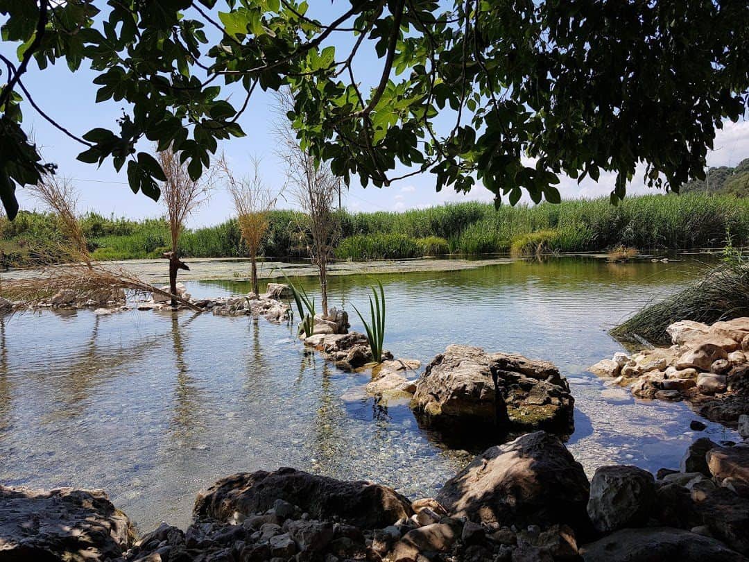
Fontana di Muro: where it really is
Let's start with a geographical clarification, because the name misleads more or less everyone. Fontana di Muro is not in Rome, it's not in the Castelli, and it's not a monumental fountain with travertine shells and marble dolphins. Fontana di Muro is a spring, and it's in the locality of Gricilli, in the municipal territory of Pontinia, province of Latina, in the area they call the lakes around here: the Gricilli Lakes and, a little farther on, the Bishop's Lakes. We're in the Pontine plain, at the foot of the last step of the Lepini Mountains, at an elevation that barely reaches 20 meters above sea level, at a point where the limestone mountain ends and the plain begins with an abrupt break.
This location explains everything else. Fontana di Muro is the point where water that entered the mountain dozens of kilometers upstream comes back out: a resurgence, not a work built to be looked at. It gushes crystal clear into a small pond with vegetated edges, in a color that shifts between emerald green and pale blue depending on how the light hits it, and with a temperature that stays almost constant all year, the unmistakable signature of spring water. Anyone who gets here by chance, maybe taking a wrong turn among the reclamation roads, is left speechless: you expect a village drinking trough and find yourself in front of a small oasis.
The listing for this proposal classifies it among the nature reserves, and it is a classification that does justice to the substance more than to the letter. Fontana di Muro is a wet spring habitat inside an intensive farming landscape, with no founding decree behind it, and for exactly this reason it has to be treated with the respect owed to fragile things. It has to be described for what it is: a tiny point of water inside an enormous landscape, which you can only understand if you understand the landscape.
The address and coordinates of Fontana di Muro
The administrative address is basic: 04014 Pontinia, in the province of Latina, località Gricilli. The coordinates place the spot at around 41.448 north latitude and 13.136 east longitude, which means, for anyone holding a map, the area between the foot of the Lepini and the first strip of reclaimed plain, northeast of the urban center of Pontinia and southwest of the town of Sezze. It's one of those areas where the GPS navigator does damage: the rural roads change name every kilometer, many are private, and the signage is what it is.
The practical advice, which I'll repeat later at more length, is to think in terms of visible landmarks and not addresses: the state road, the Sezze Romano railway station, the foot of the mountain, the line of the canals. Fontana di Muro is found with your eyes far better than with your phone screen.
Why Fontana di Muro is not where you imagine it
There is a recurring misunderstanding worth clearing up right away. In Lazio there are at least three or four similar place names, and in the place names of Apennine villages the formula "fontana di" followed by a name is very common. Anyone looking for Fontana di Muro thinking of an urban monument will find cultivated fields, ditches, water buffalo and a line of mountains. Anyone who gets here knowing they're looking for a spring, on the other hand, finds exactly what they're looking for, and almost always finds it more beautiful than they expected.
The second misunderstanding concerns scale. We are not looking at a real lake: we are looking at a body of water you can walk around in a few minutes. What's remarkable lies entirely in the quality of the water: the transparency, the visible bottom, the barely perceptible movement of the vein pushing up from below, the green algae swaying in the current like hair.
The name: what Fontana di Muro means
The name deserves a few words, because it is the first document we have of this place. "Fontana", in the place names of southern Lazio as in half of central Italy, does not mean fountain in the architectural sense: it means spring, source, a vein of water coming out of the ground. It is the Latin usage of fontana aqua, spring water, which in the medieval vernaculars becomes an independent noun and takes the place of the older fons. When in a 19th century land register of the Lepini area you read "Fontana" followed by a qualifier, almost always it is talking about a spring, not a built basin.
"Di Muro" is the interesting part. There are two plausible readings, and they don't exclude each other. The first is descriptive: the spring is or was embanked by a wall, that is by a masonry structure that held its vein, raised its level and made its water usable for watering animals, for washing, for feeding a ditch. This type, the spring set into a stone wall, with the mouth that pours and the basin below, is so widespread in central Italy that it has a technical name in the architectural literature, "fontana a muro", and anyone who has walked in the villages of the Lepini has seen dozens of them.
The second reading is topographical. In these landscapes "muro" often indicates not a man-made structure but a scarp, a sharp drop in elevation, a rock face that looks exactly like a wall. At the foot of the Lepini the transition between limestone and plain is abrupt in just this way: the mountain ends suddenly, and the springs come out along that line. Calling a spring that rises at the base of that face "di muro" is the most natural thing in the world.
The family of water names in the Agro Pontino
Fontana di Muro is not an isolated name: it belongs to a large family. Around here water has given its name to almost everything. There are the Bishop's Lakes, whose name carries the long-standing church ownership. There are the Gricilli Lakes, which give their name to the whole locality. There are the Mole, the Fontanili, the Sorgenti, the Fossi. There are the great reclamation canals, which have names out of an administrative act, Canale delle Acque Alte, Canale delle Acque Medie, Linea Pio, and the small ditches that have kept the names of farmers or saints.
This density of place names works like a hydrogeological map written in the vernacular. In a plain that for 2,000 years has had excess water as its central problem and clean water as its central resource, every spring had a name because every spring had a value. Fontana di Muro has a name for the same reason pastures in the mountains have names: because it was useful to someone, and they needed to be able to name it.
How they pronounce it here
A small note of color that is also a note of method. If you ask for directions at Gricilli or in Pontinia, you'll hear different pronunciations and forms: some will simply say "la fontana", some "le fontane", some will use the name of the nearby lake. It isn't confusion: it's the way place names really live, by useful approximation. The official name on the listing, Fontana di Muro, is the one you'll find written down. The spoken name is almost always shorter.
The geology that explains Fontana di Muro
Here comes the part that makes Fontana di Muro truly interesting, far more than its pleasant looks. This spring is the visible end of an enormous hydrogeological machine, and understanding the machine completely changes how you look at it.
The Lepini Mountains are a carbonate massif: limestones and dolomites of Mesozoic age, deposited in a carbonate platform setting when there was a warm, shallow sea here, then uplifted, folded and fractured by Apennine tectonics. Limestone has a decisive property: it dissolves in water made acidic by carbon dioxide. The rain that falls on the Lepini, instead of running along the surface and forming streams, slips into the fractures, widens them chemically over very long periods and builds an underground network of conduits, galleries, shafts and siphons. This is karst, and it is the reason why on these mountains, which do receive abundant rainfall, surface watercourses are rare and the gullies are dry for much of the year.
The water doesn't disappear, though: it goes down, collects in an aquifer, and looks for the way out. It finds it where permeable limestone meets impermeable ground, the clays and deposits of the plain, or where a fault connects the aquifer to the surface. That line of contact runs along the southwestern edge of the Lepini, exactly where we are. Fontana di Muro, the Gricilli Lakes, the Bishop's Lakes, the springs of Ninfa farther north: they are all mouths of the same system, different points where the same mountain gives back what it has drunk.
What a resurgence is and why the water is so clear
The clarity of the water at Fontana di Muro has a physical explanation, and no human credit behind it. Water coming out of a karst aquifer has passed through kilometers of rock, and the rock has worked as a mechanical filter, holding back suspended particles. So it arrives free of turbidity, and free of turbidity means transparent down to the bottom. The green-blue color you notice on sunny days comes from the way pure water, over a depth of a few meters, selectively absorbs the red wavelengths and gives back the rest.
The second signature of springs is temperature. Groundwater tends to settle at the average annual temperature of the place, and to come out at that value in every season. The result is that in summer it feels icy and in winter it feels lukewarm, when in reality it is always more or less the same. If you go on a January morning with a biting chill in the air, you may see steam rising from the surface of the water: it's the difference in temperature between water and air becoming visible. It's one of the loveliest minor spectacles in this area, and you won't find it on any postcard.
Hardness, carbonate and encrustations
Third signature: chemistry. Water that has dissolved limestone is rich in calcium bicarbonate. When it resurfaces and loses carbon dioxide, that bicarbonate turns back into carbonate and precipitates. On the edges of the veins, on roots, on fallen branches, white or cream crusts form, rough to the touch: it is travertine in the making, the same rock half of Rome is built with. Where the phenomenon is especially active you get real little petrified waterfalls.
It's worth stopping on this for a moment, because it's a thought I find very amusing. The travertine of the Acque Albule in Tivoli, the stone the Colosseum's facing is made of, comes from an identical process. Looking at a little white crust on the edge of Fontana di Muro, you are looking, on the smallest scale and in real time, at the making of the stone that monumental Rome is built with. Behind it is the same chemistry of limestone Lazio, which works everywhere mountain water comes back to the light.
Fontana di Muro and the Gricilli Lakes
The locality is called Gricilli and gives its name to a group of bodies of water that together make up one of the most distinctive wetland environments at the foot of the Lepini. Fontana di Muro is part of this system, and anyone visiting would do well to consider it as a chapter in a longer story rather than a stop in itself.
The Gricilli appear as a series of flooded basins, some almost circular in shape, fed from below by springs and connected to each other and to the drainage network by ditches. The riparian vegetation, reeds, cattails, willows, poplars, a few elms, closes in the banks and creates, in the middle of open, cultivated countryside, shady corridors that seem to belong to another region. In summer the contrast is extreme: on one side fields scorched by the sun and greenhouses, on the other a damp, leafy coolness.
We do need to be honest on one point: these environments are largely on private property, or in any case in an active farming context. There is no entrance with a ticket office, no equipped path with signs and fences as in a park. You move along rural roads, you respect the fences, you don't enter the fields. This condition has allowed these places to reach the present day without being transformed, and it is not a constraint to get around.
The difference between Gricilli and the Bishop's Lakes
People reading maps often confuse the two names, and the confusion is understandable because the two systems are adjacent and related hydrogeologically. The Bishop's Lakes are a short distance away, also in the foothill strip between Pontinia, Sezze and Sermoneta, and owe their name to their old belonging to church properties. They too are bodies of water of spring origin, with clear water and visible bottoms, and they too are set in an agricultural context.
The difference, for visitors, is more about atmosphere than substance. The Bishop's Lakes have a certain local reputation and receive more visitors. The Gricilli area, and within it Fontana di Muro, remains more secluded. Anyone looking for silence has one more reason to come here.
A minimal but dense ecosystem
On very small surfaces these environments concentrate a disproportionate biological variety. The reason is constancy: stable temperature, relatively regular flow, oxygenated water. These are conditions that allow the survival of organisms that in the surrounding plain, transformed by intensive agriculture, would no longer find a place. A spring-fed ditch crossing a cornfield is a highway for life: amphibians pass through, birds nest there, aquatic insects that need clean water take refuge there.
This is why, walking around Fontana di Muro, it pays to look down and look small. The big spectacle isn't here. The small spectacle is continuous.
Before the reclamation: the plain that surrounded Fontana di Muro
To understand why a spring like this had enormous weight in people's lives, you have to mentally erase everything you see today. No geometric fields, no straight canals, no identical farmhouses. In their place: standing water, hygrophilous woods, reed beds, dunes, seasonal pastures and a disease.
The Pontine plain was a coastal plain with difficult drainage, closed off toward the sea by dune ridges that blocked the outflow, fed by the waters of the Lepini that came down the slopes and found no way out. The result was a mosaic of permanent and seasonal marshes. In this mosaic fresh, healthy water was a precious and localized resource: the springs at the foot of the Lepini, precisely. People didn't drink the marsh water, they drank the water of the fountains. It's a distinction that seems obvious to us today and was vital then.
The settled populations lived in the mountains, not on the plain: Sezze, Sermoneta, Bassiano, Norma, Priverno, Cori, all villages perched at elevations between 200 and 600 meters, in defensible and above all healthy positions. The plain was visited, not inhabited. People came down for winter grazing, for cutting wood, for hunting, for gathering, and went back up.
The lestraioli and the lestre
The most fascinating chapter of this recent prehistory is that of the lestre. They were temporary settlements, open clearings in the Pontine forest where groups of families built huts of straw, reeds and brushwood, called lestre precisely, and lived on herding, charcoal, hunting and small trades. They moved with the seasons: down in winter with the flocks, up or elsewhere when the heat brought on the fever. Names like Lestra della Cocuzza have remained in memory and in some place names.
It was a poor, mobile civilization, on the margins of everything, and the land reclamation erased it in a few years. But it is the civilization that used springs like Fontana di Muro for centuries. When you look at that water, the historically correct image is not that of a family on an outing: it is that of a man with a donkey and two barrels, who fills up and sets off again.
Malaria as a geographic fact
It has to be named, malaria, because without it the history of this plain is incomprehensible. The anopheles found the perfect habitat in stagnant waters, and the intermittent fever made the Pontine plain a place where one could work seasonally but not live. The phenomenon is documented since antiquity: already the Latin authors speak of unhealthy air in this coastal strip, and the very term "malaria", bad air, reflects a mistaken etiological theory but an extremely exact empirical observation.
The land reclamation of the 1900s was first of all a sanitary operation, and the definitive victory came only after the Second World War with the great disinfestation campaigns, in an action that involved Italian bodies and international support. Italy was declared malaria-free by the World Health Organization in 1970: a recent date, much more recent than people imagine, and which here means something concrete.
The historical attempts at land reclamation around Fontana di Muro
The Pontine reclamation is not an invention of the 20th century: it is a two-millennia obsession, with an impressive series of failed attempts that is worth listing because each one left a mark on the terrain you cross arriving at Fontana di Muro.
The first organic intervention documented dates to the Roman Republican era, tied to the construction of Via Appia in 312 B.C. at the will of the censor Appius Claudius Caecus. Bringing a straight consular road through a marsh necessarily meant draining it at least in part, and indeed alongside the road route there ran for centuries a navigable canal, the Decennovium, so called because it was 19 miles long, from Forum Appii to the vicinity of Terracina. On that canal people traveled at night, on barges pulled by mules.
We have a literary testimony of it, first-hand and of rare sympathy: Horace, in the fifth satire of the first book, tells of his journey to Brindisi and describes the stop at Forum Appii, the boarding, the mosquitoes, the frogs, the drunk boatman who falls asleep and the mule that stops pulling, so that the passengers spend the night standing still without noticing. It is the oldest travel report on the Pontine plain, and it is funny precisely because it is in a terrible mood.
From Theodoric to the popes
The canal was restored in the Ostrogothic era: an inscription preserved in Terracina records the restoration of the Decennovium promoted under the reign of Theodoric at the beginning of the 6th century, with the reclamation of lands until then submerged. Then the system collapsed, and for almost a millennium the marsh regained the upper hand.
In the modern era the popes tried again, with mixed results. Sixtus V, at the end of the 1500s, started a great project entrusted to a technician from the Marche, the main surviving work being the watercourse that still bears his name today, the Fiume Sisto. Two centuries later Pius VI, of the Braschi family, undertook the most systematic enterprise of the papal age, reopening the Linea Pia along the Appia and draining considerable expanses: the stretch of Via Appia between Cisterna and Terracina was rearranged on that occasion and is the straight stretch one still travels today. The result lasted as long as the maintenance lasted, that is, not long.
The point to underline is this: all the failed reclamations failed for the same reason, namely because the Pontine plain is largely at a very low elevation, in some places below sea level, and drainage by gravity alone is not enough. Mechanical lifting was needed. What was needed was the pump. And that is why the matter was settled only in the 1900s.
The role of the high waters and the low waters
The technical solution that worked rests on a simple and elegant distinction, and anyone who comes to Fontana di Muro is literally crossing it. The waters that come down from the mountains, the high waters, are intercepted upstream and carried to the sea by gravity through a collector canal that runs along the foot of the mountain, never entering the low plain. The waters that instead collect in the depressed plain, the low waters, cannot get out on their own and must be lifted mechanically by pumping stations and fed into the network that goes to the sea.
The great canal of the high waters, the one that in the place naming of the 1900s bore the name of the head of the government and that today is officially Canale delle Acque Alte, is the showpiece of this architecture. The Mazzocchio lifting station, in the territory of Pontinia, is one of the beating hearts of the system. Seeing a pump at work attracts less than a temple but explains local history better than many museums.
Pontinia, the comune of Fontana di Muro
Fontana di Muro belongs administratively to Pontinia, and Pontinia is a town with a precise birth date like few in the world. It didn't grow: it was founded. It was inaugurated in December 1935 as the third of the urban centers built from scratch in the reclaimed Agro Pontino, after Littoria, today Latina, in 1932 and Sabaudia in 1934, and before Aprilia and Pomezia at the end of the decade.
This makes Pontinia a town of less than a century, and that fact changes everything about how it should be looked at. Don't look for a medieval historic center: there isn't one, and by design. What there is, is a rationalist urban layout, with a generously sized central square onto which the public buildings face, the church, the town hall, the tower, following the typical scheme of founded towns, with a grid of streets and low residential districts.
The urban plan is tied to the name of Oriolo Frezzotti, the architect who had already signed the layout of Littoria and who is the dominant technical figure of Pontine urban planning in those years. The language is that of tempered Italian rationalism, less radical and less famous than that experimented with in Sabaudia, where the group of young architects led by Luigi Piccinato produced one of the recognized masterpieces of 20th century Italian architecture, but coherent, readable and in many ways more modest and more human.
The settlers: who populated the land around Fontana di Muro
The reclamation was not only a hydraulic operation: it was a planned agrarian colonization. The Opera Nazionale Combattenti acquired and equipped the lands, built the farms and settled on them families coming largely from the Northeast: Veneto, Friuli, the lower Ferrara area, Romagna, with some from other regions. They were large families, selected also on the basis of the number of working hands available, moved en masse onto farms identified by a number.
The cultural result is one of the most surprising things in Lazio. In a territory an hour and a half from Rome, dialect varieties of the Venetian stock are still spoken today among the older generations. The surnames are those of the Polesine and the Treviso area. The cooking, in some homes, includes polenta with the same naturalness with which elsewhere they make pasta. Anyone arriving in Pontinia with an ear used to Romanesco is thrown off, and rightly so.
The rest has to be said too, without rhetoric. The settlement was hard: isolated houses in countryside just drained, malaria still present in the early years, a colonial relationship that bound the families to the agency, a culturally foreign and often hostile environment. The memory that remains is not celebratory: it is a memory of hardship, which families still tell.
The podere, the unit of measure of the landscape
When you drive through the countryside around Fontana di Muro you cross a landscape with a precise unit of measure: the podere. Each podere had its farmhouse, its stable, its well, its henhouse, and an area calibrated to what one family could work. The original farmhouses are still recognizable: simple volumes, light plaster, gabled roof, often a number painted on the facade.
Many have been enlarged, others abandoned, others replaced by sheds and greenhouses. But the pattern remains readable, and it is a 20th century pattern laid over a very ancient geography. Springs like Fontana di Muro are the points where the ancient geography surfaces through the new pattern.
The migliare: how the roads are numbered here
A practical detail that is also a piece of history. The rural roads that cut perpendicular to the main axis of the Agro Pontino are called "migliare" and are numbered progressively. The number comes from the historical kilometer count measured in miles along the axis of the Appia. The result is that here, instead of saying "the road to such-and-such place", people say "Migliara 45" or "Migliara 51".
For the visitor it's a godsend: it means that once you understand the system, finding your way becomes trivial. The migliare run parallel to each other, perpendicular to the main axis, and the numbers grow in a precise direction. It's a Roman land-survey grid applied in the 20th century, and it is, in its way, beautiful.
The Lepini Mountains behind Fontana di Muro
Turn toward the northeast while standing in front of Fontana di Muro and you have the real wall: the face of the Lepini Mountains, which rises almost theatrically from the plain. It is the backdrop of every photograph you'll take here, and it deserves to be described because it is the factory of the water you're looking at.
The Lepini are a limestone massif extending between the provinces of Rome, Latina and Frosinone, bounded to the southwest by the Pontine plain and to the northeast by the Sacco valley. The main peak is Monte Semprevisa, which exceeds 15 hundred meters: a respectable elevation, made impressive by the fact that the base is almost at sea level, so the apparent drop is enormous. From certain points on the plain you see the whole mountain at a glance, from root to summit.
The morphology is typical of carbonate reliefs: ridges, sinkholes, karren fields, swallow holes, caves. The vegetation cover alternates holm oak woods and scrub on the warm slopes facing the plain, beech woods at high elevations and on the cool slopes, and vast areas of pasture that are the result of centuries of transhumance. It's a mountain that seems arid and is in fact saturated with water: it's just that the water is underneath.
Where the mountain ends and the plain begins
The line of contact between the Lepini and the plain is one of the sharpest geographical boundaries in Lazio. There is no transitional hill belt worthy of the name: there is the mountain and then there is the flat. This depends on tectonics: the Tyrrhenian edge of the Lazio Apennines is lowered by a system of faults that has sunk the block of the plain relative to that of the mountains.
That tectonic step is exactly the reason Fontana di Muro exists. The fault connects the mountain's aquifer with the surface of the plain, and the water under pressure rises. All the main springs at the foot of the Lepini are lined up along that line, and if you mark them on a map you get a string of pearls that draws the fault better than any popular geological survey.
The villages hanging above Fontana di Muro
Lifting your eyes you see the towns. Sezze sits perched on its spur at a little over 300 meters, with the historic center sloping toward the plain and a view that on clear days reaches the sea and the Circeo promontory. Sermoneta stands out for the square mass of its castle. Farther east are Bassiano, Roccagorga, Maenza, Priverno.
This arrangement, towns up high, fields down low, is the signature of a sanitary and defensive history together. And it means that a visit to Fontana di Muro can easily become a vertical day: half an hour of water on the plain and then the climb to a village for lunch and the view. It's the best way to use this territory.
Water and public fountains in the villages of Lazio
Fontana di Muro is a natural spring, but its name pulls in a whole chapter of material culture that deserves to be told because it is the context in which a spring like this took on meaning: the public fountains of the villages.
In Lazio, as in all of central Italy, the public fountain was for centuries the civic infrastructure par excellence. Not an ornament: a service. Whoever controlled the spring controlled the town, and it is no accident that medieval municipal statutes devote meticulous articles to managing water: who may draw, in what order, with what containers, who may water animals and where, who may wash clothes and in which basin, what fines for those who dirty it.
The classic type has three functional levels arranged in a cascade and in strict hierarchical order. At the top the mouth that pours, with the basin of drinking water, which has to stay spotless. Below, fed by the overflow of the first, the trough for animals. Lower still, fed by the overflow of the second, the washhouse for clothes. The water goes through a progressive degradation of quality, and nobody can skip the line. It's an elementary and ingenious sanitary machine, and it is the same everywhere, from Cori to Bassiano to Norma.
The wall fountain as an architectural type
The type that probably gives our place its name is the fountain set against a wall: a masonry front, often in local stone, with one or more spouts, masks, taps, plain pipes, and an elongated basin at the base. The reason for the wall is practical: it supports the weight of the water and fixes the pipes, and it often makes use of an existing retaining wall along a sloping road.
In the Lepini villages you find them from every era: plain medieval ones, 16th century ones with coats of arms, 18th century ones with inscriptions celebrating the patron, 19th century ones with the writing recalling the administration that had them built. It is an open-air archive: the fountain records who was in charge and when.
The washhouse and its sociology
Washhouses deserve a paragraph of their own, because they are the place where hydraulic infrastructure becomes social infrastructure. The washhouse was the women's space par excellence, the place where information was exchanged, marriages arranged, reputations destroyed, songs learned. The sloping stones on which clothes were scrubbed are often worn in the center by a hollow: that hollow was dug by hands, over generations.
With the arrival of running water in homes, between the 1950s and 1960s, washhouses died within a very short time. Many were demolished, others turned into storerooms, some restored as monuments. When you find one still working, with its water flowing, you are looking at the last piece of a world that ended within a generation.
Why a spring on the plain was worth more than one in the mountains
Let's go back to Fontana di Muro with this key in hand. In the mountains the springs are fairly plentiful and the villages were built on top of them. In the Pontine plain, by contrast, water was everywhere but almost all of it bad: stagnant, cloudy, malarial. A resurgence spring that gave clear, fresh water in the middle of that expanse was a functional rarity, a reference point that oriented the routes of grazing, transport and rest.
That is why a tiny spring like this one has a name of its own and appears on the maps. Not for beauty: for usefulness. We attributed the beauty to it afterward, when the usefulness passed to the aqueduct.
The nature around Fontana di Muro: the vegetation
Walking slowly around the body of water you cross, in a few meters, three or four different plant environments. It is a useful exercise, because it teaches you to read the moisture gradient better than any manual.
On the wet edge, with feet literally in the water, stand the helophytes: the marsh reed, which forms compact and tall reed beds, and the cattail, recognizable by the brown cigar-shaped flower spike that stays standing all winter. These are plants that have air-bearing tissues to carry oxygen to the submerged roots, and that form dense belts in which water birds nest and hide.
A little higher up, where the ground is moist but not flooded, the water-loving tree belt begins: the willows, with the white willow being the water tree par excellence and the shrubby willows that colonize the edges of the ditches, the black poplar and the white poplar, the black alder where the conditions are right. These are soft woods, fast-growing, that resprout vigorously after cutting: for this reason they were exploited for centuries as wicker, poles and firewood.
Higher still, on the dry rise, the Mediterranean species reappear: a few holm oaks, the field elm along the hedgerows, the bramble that invades every unmowed margin, and the herbaceous plants of the cultivated fields. The passage from reed bed to bramble is a matter of a meter and a half of elevation, and this meter and a half tells the whole ecology of the place.
Submerged plants and algae
In the transparent water you can see the bottom, and on the bottom you can see the plants. The submerged macrophytes, pondweeds, hornworts and water speedwells in the stretches with current, form green meadows that sway in the vein of the spring. They are the most immediate biological indicator of water quality: where the water is polluted by nutrients the communities simplify and filamentous algae prevail, smothering everything.
In the stretches with livelier current you sometimes see watercress, which people here have always gathered and eaten. A serious warning, though: gathering wild watercress in environments frequented by livestock carries a real health risk linked to parasites, and it is not something to do lightly. Look at it, photograph it, leave it there.
Seasonal blooms
Whoever comes between March and May finds the best moment from the botanical point of view. The edges of the ditches fill with buttercups, the tree vegetation is in new leaf with that tart green that lasts three weeks, and the damp meadows not yet mown show a variety that disappears as soon as the cutter bar passes. In June and July the dark, compact green of the reed bed dominates. In autumn, the yellow of the poplars. In winter, the bare structure, which is the moment when you see best how the place is made.
I add a note that holds for the whole Lepini foothill belt: spring here is early. The combination of low elevation, southwest exposure and the shelter of the mountain from cold winds brings the blooms forward compared with the interior. In February, when in Rome it is still full winter, the almond trees here are already in bloom.
The animals you see at Fontana di Muro
I don't promise a safari. I do promise, though, that whoever is patient and keeps quiet sees a lot, and that whoever arrives talking loudly sees nothing. The difference between the two experiences is entirely in the behavior of the visitor.
Birds are the most visible component. On the ditches and bodies of water of the foothill belt you regularly see gray herons and little egrets, fishing motionless on the edges, the moorhen that runs off into the reed bed with its nervous movement of the tail, the kingfisher that passes like a sliver of blue and turquoise and announces itself with a sharp whistle before being seen. In the reed beds the reed warbler sings, and its repetitive song is the soundtrack of May.
Then there are the species of the agricultural setting: magpies, gray crows, starlings in enormous flocks at winter sunset, the kestrel perched on the wires, the little owl on the farmhouses. And, above all, on days with thermals, the raptors that use the Lepini wall as a launch ramp: buzzards above all, and with luck something rarer.
Amphibians and reptiles
Resurgence environments are crucial for amphibians, which need water to reproduce and which in the intensive plain have lost almost all the available sites. Green frogs, toads, newts in the right spots: in spring the night choruses are impressive, and whoever happens by at twilight in March notices right away. It is worth remembering that amphibians are in global decline and that every pond counts.
Among reptiles, the grass snake is the most common presence and the most misunderstood. It's an absolutely harmless water snake, an excellent swimmer, that flees at the slightest vibration and at most, if grabbed, releases a foul-smelling secretion. When someone points out "a viper in the water" it is a grass snake, because vipers don't stay in water. Then there are lizards everywhere and, on the warm low walls, the green lizard with its impossible green.
Insects, dragonflies and the question of mosquitoes
Dragonflies deserve a dedicated look. Over the clear, flowing waters fly damselflies in metallic colors, with that intermittent flight of a faulty helicopter, and true dragonflies patrolling fixed territories. They are formidable predators and indicators of water quality: their larva lives submerged for years and does not tolerate pollution.
On mosquitoes I have to be honest: they're there. In a wet environment in southern Lazio, between May and October, they're there and on some evenings they're aggressive. It is no longer a matter of malaria, that chapter has been closed for over half a century, but of nuisance. Repellent and long sleeves at dusk are not an affectation.
The water buffalo, protagonists of the landscape
You can't talk about the countryside around Pontinia without talking about water buffalo. Buffalo farming is one of the strong economic vocations of this territory, and the black herds standing in water up to the withers are an image that throws off anyone expecting a conventional Lazio landscape.
The Italian Mediterranean buffalo has a physiological relationship with water: it has few sweat glands and needs to immerse itself to regulate its temperature. Hence the wallow, the mud, the image everyone knows. Historically, buffalo farming was precisely the livestock answer to marshy environments, where ordinary cattle couldn't cope: the animal others regarded as a fallback has become the basis of one of the most profitable dairy chains in Italy. The reversal is total, and it is recent.
Fontana di Muro and the Circeo National Park
A short distance from here, toward the sea, begins one of the oldest national parks in Italy. The Circeo National Park was established in 1934, in the middle of the reclamation, with a logic we would call compensatory today: while the marsh was being drained, they decided to save a piece of it.
The park includes four very different environments. The Selva, the remnant of the great Pontine lowland forest, with its oak woods and its piscine, depressions that flood seasonally and are the last true relic of the original environment. The coastal dune, a very long sandy ridge with its sand-loving vegetation. The brackish coastal lakes, Fogliano, Monaci, Caprolace, Paola, which are resting and wintering areas for water birds of international importance. And the Circeo promontory, an isolated limestone block that rises from the sea like a missed island, with its scrub and its caves. The island of Zannone, in the Pontine archipelago, also belongs to the park.
The link with Fontana di Muro is not just proximity: it is systemic. The waters that come out of the foothill springs like this one feed, through the network of canals, the entire water balance of the plain down to the coast. The quality of what comes out at Gricilli has repercussions, mediated by kilometers of canals and farming uses, on what reaches the coastal lakes. It is an elementary lesson in river basins that you can touch with your hand here.
The promontory and the Neanderthal cave
On the side of the Circeo that faces Terracina, in 1939, during building work near a hotel, a cavity sealed for millennia was found, and a Neanderthal skull was discovered in it. The find at Grotta Guattari is one of the most famous in European prehistory, and in recent years further research in the same cavity has yielded new remains that brought the site back to international attention.
What does it have to do with Fontana di Muro? It has to do with the fact that human presence in this piece of Lazio is very ancient, and that the attraction was exactly the combination of mountain, wet plain and sea, that is three different environments reachable in a day's walk. That combination is still there, and it is still the reason it's worth being here.
A tip on combining the two places
If you have a whole day and want an itinerary that makes narrative sense and not just logistical sense, it's best to follow the path of the water from the spring to the sea: morning at the springs at the foot of the Lepini, with Fontana di Muro and the Gricilli lakes. Midday in a Lepini village for lunch. Afternoon at the coastal lakes of the Circeo or at the Selva. In six hours you have followed a drop of water from its exit from the mountain to its outlet in the sea, crossing 2,000 years of hydraulic history. It is the smartest way to visit this province.
Ninfa, the other water garden near Fontana di Muro
A little farther north, still along the foot of the Lepini and still fed by the same system of springs, is the place that made the water of this strip famous around the world: the Giardino di Ninfa, in the territory of Cisterna di Latina, at the foot of Norma and Sermoneta.
The story is one of those that seems made up. Ninfa was a real medieval town, with churches, towers, a castle, walls, a bridge, grown around the springs and on the road that linked the plain to the mountains. It was prosperous in the 13th century, a pope was crowned there, and then it declined, hit by conflicts between families, by malaria and by the shifting of trade routes. Over the centuries it became completely depopulated and the ruins were swallowed by vegetation: a dead town in the middle of the water.
At the beginning of the 20th century the Caetani family, which had held those lands for centuries, began the recovery: reclamation of the area, conservative restoration of the ruins and, over and within the ruins, the creation of a garden in the Anglo-Saxon taste, informal, where plants from all over the world live alongside medieval walls and a river of crystal-clear water. The work spanned three generations, and on the death of the last heir the complex passed to a foundation that still administers it and regulates access.
Ninfa today is a heavily visited garden, with limited admission and a mandatory guided visit at certain times of the year. It is the exact opposite of Fontana di Muro: monumental, famous, organized, crowded. That is precisely why the comparison is instructive, and precisely why I recommend that anyone who has seen Ninfa come to Gricilli, and vice versa. They are the same natural phenomenon with two opposite cultural destinies.
The same water, two different outcomes
You can think of this foothill strip as a necklace of springs on which history has hung very different objects. On one spring a medieval town arose that later became a romantic garden. On another a mill arose. On yet another, like here, nothing monumental arose, and the spring stayed a spring.
This is not a value judgment. It is, if anything, a reminder that natural heritage doesn't need to have been chosen by history to deserve attention. Fontana di Muro isn't famous because it didn't have the luck of lying beneath a Caetani castle. Its water, though, is the same.
Via Appia and the ancient places near Fontana di Muro
Anyone arriving here by car crosses, almost certainly without realizing it, one of the most important road routes in European history. Via Appia, opened in 312 BC, cuts the Pontine plain with a straight stretch of dozens of kilometers that is still today the backbone of local roads.
On that straight stretch were the Roman-era posting stations. Forum Appii, the market at roughly the 40-third mile, was the embarkation point on the canal and a lively commercial hub. Tres Tabernae, farther north, was another well-known stop. Both appear in the Acts of the Apostles, in the account of Paul's journey to Rome: the brothers of the Roman community came out to meet him as far as the Forum of Appius and the Three Taverns, and Paul, seeing them, gave thanks and took courage. They are two Pontine place names in a text read all over the world, and for a plain that thinks of itself as peripheral, that is no small thing.
Farther south, Terracina preserves the cut of the Pisco Montano, the rock face artificially carved to let the road pass at sea level, with Roman numerals carved into it marking the progressive height of the excavation up to a hundred and 20 feet. It's a truly impressive monument of road engineering, and you can see it from the road.
Privernum and its history
In the territory of Priverno, a short distance from here, are the remains of the ancient city of Privernum, with an archaeological area that has yielded urban layouts, mosaics and structures of the Roman era. The Volscian city was conquered by Rome in the 4th century BC, and the literary tradition made it the homeland of a famous figure: Camilla, the virgin warrior of the Aeneid, daughter of Metabus, king of the Volscians of Privernum, whom Virgil has die in battle in the eleventh book.
That it is legend takes nothing away: it means that in the Augustan imagination this area had a role, and that the Volscians were a memory still alive. The Lepini are Volscian land before being Roman land, and the villages we see today as Christian and medieval have polygonal walls underneath: at Cori, at Norba, at Sezze, you can still see the cyclopean blocks set in place without mortar.
Norba, the murdered city
Above Norma, sheer over the plain, are the remains of Norba: a fortified Latin city with imposing polygonal walls and monumental gates, destroyed during the civil wars at the beginning of the 1st century BC and never rebuilt. From the edge of its walls you overlook the whole Pontine plain down to the sea, and on clear days you can make out the coastal lakes and the Circeo.
It is, in our judgment, the most impressive viewpoint in the whole province, and it is barely half an hour from Fontana di Muro. From up there you understand, at a glance, everything explained so far in words: the wall of the mountain, the line of the springs, the grid of the reclamation, the canals, the sea.
Villages to combine with a visit to Fontana di Muro
Fontana di Muro alone is half an hour. A day is built around it, and the territory offers plenty within a 20-kilometer radius. Here is how to organize it.
Sezze, the balcony over the plain
Sezze is the town that sits exactly above us. A center of very ancient origin, with stretches of polygonal walls still visible, it spreads over a spur with steep lanes, staircases and continuous views over the plain. The main square, the cathedral, the municipal archaeological museum and above all the viewpoints are worth the climb.
Two things make Sezze special on the calendar. The first is the artichoke: the local variety is the town's signature agricultural product, celebrated by a spring festival that is one of the best attended in the province. The second is the Passion, the Good Friday sacred representation, with hundreds of costumed participants moving through the town. It's a long-standing tradition and an event that completely changes the face of the town for a day.
Sermoneta and the castle
Sermoneta is perhaps the most photogenic village of the western Lepini: a remarkably well-preserved medieval layout, with the square, the Loggia dei Mercanti, the cathedral with its Romanesque bell tower and, at the top, the Castello Caetani, a fortress that keeps its keep, its walkways and its interior rooms and can be visited.
The castle tells a story of families that is the very history of southern Lazio: first the local lords, then the Caetani, then the passage to the Borgia under Alexander VI, then the return to the Caetani. The bastioned fortifications you see on the outside belong to that 16th century phase of adaptation to firearms.
Bassiano, prosciutto and Aldo Manuzio
Bassiano is a small walled village, perched higher up, and it has two titles to fame out of proportion to its size. The first is gastronomic: Bassiano prosciutto, cured by taking advantage of the town's ventilated microclimate, is a product with an established reputation well beyond the provincial borders.
The second is cultural and is the kind that raises an eyebrow: Aldo Manuzio was born here, around the middle of the 15th century, the greatest publisher of the Renaissance. He is the man who in Venice invented the pocket book, who gave shape to italic type, who printed the Greek classics and who in effect invented many of the typographic conventions with which we still read today. That he comes from a village of a few hundred inhabitants in the Lepini is one of those facts that make Italy what it is.
Priverno and Fossanova
A little to the east, in the territory of Priverno, stands the abbey of Fossanova, one of the most important monuments of southern Lazio. It is the first Cistercian complex built in Italy, with the church consecrated at the beginning of the 13th century, and it represents the entry of Burgundian Gothic into the peninsula: severe lines, absence of decoration, calibrated light, the cloister with its small columns, the chapter house, the refectory.
It also has a precise historical note: here, in March 1274, Thomas Aquinas died while on his way to the Council of Lyon. The cell in which he expired is still pointed out to visitors. Anyone with an interest in the history of philosophy will find it curious to stand in the place where the greatest intellectual enterprise of the Middle Ages was cut short.
Terracina and the sea
To the southeast, half an hour by car, is Terracina, which joins a Roman and medieval historic center to a seafront. Up high, on Monte Sant'Angelo, the temple known as the Temple of Jupiter Anxur dominates the gulf with its supporting arches: the view at sunset from up there is the kind that ends a day well. Down below, the Aemilian forum with its original paving and the inscription of the magistrate who had it made is one of the best-preserved Roman forums outside Rome.
When to go to Fontana di Muro: the seasons
The most frequent question is which is the best time. The honest answer is that it depends on what you're looking for, but if I had to choose a single month I'd say April.
Spring
From mid-March to the end of May is the moment when everything works. The vegetation is new, the springs' flow is at its maximum because they discharge the winter rains, the birds are in territorial song and therefore much more visible, the amphibians are breeding, the temperatures are perfect for walking. Add that the Lepini villages in spring have a dense calendar of festivals and feast days, and you have the complete package.
A warning about mud: after rainy periods the rural roads and the edges of the ditches can be impassable in city shoes. Wear walking boots or at least shoes that can get dirty.
Summer
From June to August the foot of the Lepini is hot and humid, and the air at midday is heavy. The advantage of summer is twofold. The first is that the springs are the only cool place within kilometers: the air above the water is noticeably cooler than the neighboring field, and the shade of the willows does the rest. The second is that, while everyone is on the coast at Sabaudia and San Felice, there is nobody here.
The rules for summer are three: come early in the morning, bring water, put on repellent. And don't think about swimming: it isn't that kind of place, the water is private or in any case not equipped, and spring-fed bottoms are treacherous.
Autumn
September and October are, for those who love light, perhaps the most beautiful period of all. The low sun crosses the water diagonally and turns it into a sheet of colored glass, the poplars turn yellow, the countryside empties after the harvests, and the morning mist rising from the ditches creates scenes that look painted. The first autumn rains get the flows going again after the summer low.
It is also olive and olive mill season in the Lepini, with the new oil appearing in November. If you combine a visit to the springs with a stop at an olive mill in the area, you have a day worth the trip.
Winter
December to February is the purists' season. It's cold and damp, the vegetation is bare, there is no color. On the other hand you see the structure of the place without filters, the water is at its maximum transparency, and on frosty mornings the steam rising from the surface is a spectacle that by itself justifies the early start. On the mountain behind, when it snows, a formidable contrast is created: snow on the Lepini ridge and green on the plain, in the same frame.
I'll add that winter is the best season for birdwatching on the Pontine plain in general, because of the wintering birds that arrive at the coastal lakes. If you come in January, the right day pairs the springs in the morning with the coastal lakes in the afternoon.
How to get to Fontana di Muro
I start from the realistic assumption: you get there by car. There is no public transport service that takes you to a spring in the middle of the countryside, and it would be unrealistic to expect one.
By car from Rome
From Rome the logic is to head south and then cut toward the foot of the Lepini. The two routes are Via Pontina, which leads toward Latina and the plain, and Via Appia, which goes down through Cisterna and Latina and continues toward Terracina. From both you reach the territory of Pontinia and from there you climb toward the foothill strip in the direction of Sezze.
Realistic times, traffic permitting, are on the order of an hour and a quarter or an hour and a half from the Grande Raccordo Anulare. On summer weekends the whole bundle of roads toward the Pontine coast suffers: leave early or resign yourself.
By train
There is a partial rail option worth mentioning because it's convenient and few people know it. The Rome-Naples line via Formia has a station called Sezze Romano, which like almost all the stations in the area is on the plain and not in the town that gives it its name. From there the territory of the springs is reachable, but you still need a vehicle or a bicycle: on foot the distances are awkward and the roads have no sidewalks.
The elegant solution, for those who don't want to drive, is to arrive by train with a bike in tow. The plain is flat, the grid of the migliare is ideal for cycling, and by bicycle you see infinitely more than by car.
By bicycle
I insist on the bike because this is, objectively, bicycle territory. Straight roads, no elevation change, modest traffic on the rural roads, open landscape, and the possibility of linking springs, canals, historic farms and founded towns in a single day. The only warning is the wind: on the open plain, with the sea nearby, the wind can be serious and has to be factored into route planning.
Where to park and how to behave
There is no dedicated parking lot. You stop in pull-offs along the rural roads, and the golden rule is never to obstruct access to a farm field: those gates serve vehicles three and a half meters wide, and a badly parked car can block someone's working day. Don't enter the fields, don't climb fences, don't open gates. If you meet someone working, say hello and ask: in the Pontine countryside courtesy works much better than rights.
What to really expect from a visit to Fontana di Muro
I'll start with a dose of realism, because I prefer an informed visitor to a disappointed one. Fontana di Muro is not equipped. There is no ticket office, no café, no restroom, no visitor center, no marked trail, no educational panels. There is a spring, fields, ditches and mountains.
This means that the value of the visit depends almost entirely on how much you know before you arrive. In a place without mediation, you have to carry the mediation in your pocket. Anyone who arrives knowing what a resurgence is, how Lepini karst works, what was here before the reclamation and who built the canals, spends a very rich hour. Anyone who arrives without knowing sees a puddle.
The right time to give it, as a single stop, is between 20 minutes and an hour. As the core of a day that includes the Gricilli, a Lepini village and perhaps the Circeo, we're talking about six to eight full hours.
What to put in your backpack
Closed shoes that can get dirty, always. Water, because you won't find any. Insect repellent from May to October. Binoculars, even modest ones, which radically change the experience here. A hat in summer. A windbreaker in winter, because the open plain is colder than the thermometer suggests. And a bag to carry your trash back, which should be obvious and isn't.
Accessibility
It must be said clearly: the terrain is natural, uneven, often muddy and without equipped paths. It is not a place suited to those with significant mobility difficulties, and it is not comfortable with strollers. Anyone with accessibility needs will find much more satisfying, in the same area, the equipped lakefronts of the Circeo or the flat historic centers of the foundation towns.
With children
With children, on the other hand, it works very well, on two conditions. The first is supervision: deep water, slippery banks, no protection. The second is giving them a task. A list of things to find (a dragonfly, an animal track, a plant with cigar-shaped leaves, a white crust of limestone) turns a boring walk into a treasure hunt. The place rewards those who look closely, and children are naturally better than adults at doing so.
The food around Fontana di Muro
You eat well, and you eat in a way that reflects exactly the historical layering already described: a Lepini mountain base, a Venetian overlay brought by the settlers, a seafaring graft from the coast and a buffalo supply chain that is the true economic novelty of the 20th century.
Buffalo and cheeses
The buffalo mozzarella produced in this province is of excellent quality and you buy it directly at the farm dairies, of which there are many here. The advice is to buy it the same day and not to put it in the refrigerator if you eat it within a few hours: cold mozzarella loses half of what it has to say. Besides mozzarella you find buffalo ricotta, smoked provola, and in recent years also yogurt and aged cheeses made of buffalo milk.
Garden produce
The Pontine plain is one of the most productive vegetable-growing areas in Italy, and this shows on the market stalls. The artichoke of Sezze in spring, the kiwi that made the economic fortune of this area in recent decades, melons, watermelon, tomatoes. A lot of the production is in greenhouses and a lot is destined for large-scale retail, but the weekly markets of the towns remain excellent.
Mountain cooking and settler cooking
Going up into the Lepini you find dishes of a completely different register: handmade pasta, legumes, mutton and goat meats, the famous prosciutto of Bassiano, sheep's-milk cheeses. On the plain, in the houses of Venetian origin, polenta, risi e bisi, certain sweets and certain habits that do not exist in Rome survive. The coexistence of these two repertoires in the same province is one of the most curious gastronomic facts of Lazio.
Where to stop
I don't name places, for a reason of method: the signs change, and a page that recommends a restaurant closed for three years is worse than a page that doesn't recommend it. The criterion in this area is simple. On the plain you eat well at the agriturismi tied to a real farm, the ones that also sell their products. In the Lepini villages you eat well at trattorias with a short, seasonal menu. On the coast, at Terracina and around, you eat fish, and the criterion is the presence of places with local clientele at lunch on weekdays.
Water as a cultural theme in Lazio, from Fontana di Muro on up
A digression that is anything but idle is worth making, because it helps to understand why a spring in the middle of the fields belongs to a great story.
Lazio is the Italian region in which the relationship between civilization and water has been the most explicit and the most monumental. Rome built its urban power on a system of aqueducts that brought into the city quantities of water per capita that Europe would not see again for 1,700 years. And every Roman aqueduct begins where Fontana di Muro begins: from a spring. The Anio Vetus and the Anio Novus drew from the Aniene, the Aqua Marcia from springs of the upper Aniene valley, the Aqua Virgo from veins in the countryside east of the city. The founding technical gesture is always the same: you identify a spring, you enclose it in a masonry structure, and you lead it away.
The fact that a spring is called "Fontana di Muro", that is, literally, spring enclosed in masonry, places it in this genealogy. The wall around the spring is the same gesture as the Roman caput aquae, on a minimal scale and without an inscription.
The deities of the springs
Before engineering there was cult. In the Italic world springs were sacred, and not in a generic way: they had titular deities, offerings, sanctuaries. Feronia, a goddess of the Sabine and Latin area, was linked to waters and woods and had a prominent sanctuary in southern Lazio itself, near Terracina, where a very well-attended fair was held and where, according to the sources, manumissions of slaves were celebrated.
The sanctuary of the Aquae Albulae near Tivoli, the springs of Juturna in the Roman Forum, the grove of the nymph Egeria outside Porta Capena where Numa Pompilius received the advice of his divine counselor: the spring is, in the Latin imagination, the place of encounter between human and divine. And the very name of Ninfa, a little north of here, comes in all likelihood from a temple dedicated to the nymphs that stood near those waters.
I'm not saying there was a sanctuary at Fontana di Muro: I don't know, and I wouldn't say so without evidence. I'm saying that the attitude of almost religious respect before a spring coming out of the ground is not a new age affectation, it is a very deep cultural reflex of these lands, and that feeling it in front of this water simply means being connected to a way of looking that is 3,000 years old.
Springs and saints
Christianity did not erase that relationship, it rewrote it. Countless springs in central Italy are associated with a saint who supposedly made them gush forth with a gesture, or with a miraculous healing, or with an apparition. In Lazio the range of cases is very rich and involves almost all the local patron saints. The structure of the story is almost always the same: drought, invocation, a blow of a staff or a knee, water.
Behind that narrative structure is a social fact: the spring was a contested property, and attributing it to a saint meant attributing it to the community and removing it, at least symbolically, from the local lord. The popular religion of water is also a form of customary law in disguise.
Fontana di Muro and the question of protection
It's worth tackling directly a theme that hovers over this whole account: what protects an environment like this today?
The sincere answer is: little, and not directly. We are not talking about a national park with a perimeter, rangers and regulations. We are talking about small wetland environments set in a productive agricultural matrix, mostly on private property. The tools that actually have an effect are indirect: water legislation, wide-area landscape restrictions, agricultural policy rules on ditches and buffer strips, possible inclusion in the boundaries of the regional ecological network.
The pressures, on the other hand, are direct and concrete. The first is groundwater extraction: the Pontine plain is an area of very heavy water consumption for intensive agriculture and for domestic uses, and the Lepini karst aquifer is the source. When large volumes are withdrawn, spring flows drop and in extreme situations the springs can shrink drastically in summer. The second is quality: fertilizers and livestock effluent can enrich the waters with nutrients, resulting in eutrophication, a boom in filamentous algae and the loss of sensitive species. The third is banal but real: dumped trash.
I don't say this to preach, but because I believe that knowing what threatens a place is part of understanding it. And because the behavior of the individual visitor, here, has a greater relative weight than at a monumental site: 10 rude people in a year show, on a pool of this size.
The minimum code of conduct
I sum it up in five lines, and they are five non-negotiable lines. You don't go into the water and you don't swim. You don't pick plants or take animals, tadpoles included. You don't light fires, ever, in any period of the year. You don't leave anything, not even organic, because a banana peel in a wet environment is not fertilizer, it is trash. You don't make noise: silence is the real tool of nature observation.
Slow tourism as a possible alternative
In recent years the Pontine plain has started to play an interesting card, that of bike touring and slow tourism along the canals and rural roads. It is a vocation that makes sense: the territory is flat, it has an orderly road grid, it has a recognizable heritage of 20th century architecture and it has, precisely, water. If this direction consolidates, places like Fontana di Muro can move from invisibility to a sustainable visibility without having to become attractions.
This is the scenario I hope for. The alternative, which has been seen elsewhere, is sudden discovery through a viral photograph, with hundreds of people arriving on the same weekend at a place that has no parking, no restrooms and no supervision. We all know how that ends.
The reclamation landscape as cultural heritage
Something that often surprises: the Pontine plain, with its straight canals, its serial farmhouses and its founded towns, is a cultural landscape of the first rank, not a banal landscape.
The reason is that it is one of the very few cases in Europe in which a territory of this extent was designed in its entirety, in a very short time, according to a unified plan: hydraulics, roads, farms, service villages, urban centers. Everything was conceived together, by a single entity, in less than a decade. The result is readable like a text, and anyone who learns the alphabet, the migliare, the collector canals, the pumping stations, the building types of the farmhouses, the village-to-town hierarchy, can literally read the countryside by driving through it.
It must be added, and added without reticence, that this design is the child of a totalitarian regime and that it was used for propaganda purposes on an international scale: the reclamation was the showcase of Fascism, filmed, photographed, put on display. Recognizing the urbanistic and engineering value of the work and recognizing the nature of the political context in which it was carried out are not contradictory operations: they are the same operation, that is looking at the whole history instead of half. Anyone visiting Pontinia should know both things.
The rural service villages
An element of the system that almost always escapes visitors is the rural villages: small settlements designed to serve a sector of countryside, equipped with a church, school, clinic, general store, police station, party house. There are several in the Pontine territory and many keep their original layout. They are, on the smallest scale, the idea of a planned civilization: the farmer was not supposed to travel more than a few kilometers to find essential services.
Many today are semi-abandoned or repurposed, and passing through them has something melancholy about it. But they are extraordinary documents, and for anyone interested in 20th century architecture they are worth the detour.
The local history museum
In Pontinia there is a museum institution dedicated to the memory of the Pontine land and the reclamation, with materials, tools, documents and testimonies of the settler families. It is the perfect complement to a visit to the springs: outside you see the result, inside you understand the process and hear the voices of those who lived it. I recommend checking in advance the terms and opening days, because local museums have variable hours.
Fontana di Muro for those coming from Rome
A separate chapter for those arriving from the capital, because how to fit this destination into a Roman itinerary is not obvious.
The first point is about expectations. Anyone with two or three days in Rome shouldn't come here: they should stay in Rome. Fontana di Muro is a destination for those who have already seen the essentials, for those who live in the area, for those returning to Rome for the second or third time who want to understand Lazio instead of redoing the Colosseum, or for those with a specific passion, nature, geology, 20th century history, landscape photography.
The second point is about format. This is not a half day: it's a day. With travel times, an outing that includes springs, a Lepini village and perhaps the Circeo takes eight to 10 hours door to door. Compressed into less time, the game isn't worth the candle.
The third point concerns comparison with the other classic day trips out of town. The Castelli Romani are closer, better served and easier. Tivoli has two World Heritage villas and is reachable by train. Ostia Antica is an hour by metro and delivers an entire Roman town. If you have only one day outside Rome in your life, these take precedence, and I'd be dishonest to say otherwise. If you have several, and you want the one where you don't run into an organized group, then come here.
The value of anticlimax
There is, though, an argument in favor that counts. After three days of Rome, where every corner screams masterpiece and every square is full, a morning in front of a pool of clear water in the middle of the fields, with the mountains behind and no one around, has a mental cleansing effect that is worth more than another museum. High-density cultural tourism is tiring, and the remedy is not another monument: it is silence.
Even someone who has just seen the Vatican Museums and the Galleria Borghese can go home with a sharper memory of everything else: the steam rising from the water of a spring at eight in the morning. It's not a paradox: it's how memory works.
Frequently asked questions about Fontana di Muro
Can you swim at Fontana di Muro?
No, and not out of pedantry. It is not an equipped bathing area, much of the surrounding land is private property, the spring-fed bottoms are uneven, with submerged vegetation and cold veins, and the water is colder than the surface suggests. In addition, a spring is a very delicate environment: trampling the bottom and sunscreen do real damage.
Do you pay an admission fee?
There is no ticket office because there is no visitor facility. That said, the absence of a ticket does not mean a right of access everywhere: many fields are private and must be respected as such.
How much time do you need?
From 20 minutes to an hour for the spring itself. A full day if you build the expanded itinerary with the Gricilli, a Lepini village and the coast or the Circeo.
Is it suitable for dogs?
In an agricultural setting with livestock and in a sensitive natural environment, the leash is not an option but a necessity. A dog that goes into the water or disturbs nesting does real damage, and a dog that approaches buffalo herds puts itself and you at risk. Buffalo are big, territorial animals when they have calves.
Are there services, cafés, restrooms?
No, none. Services are found in Pontinia or Sezze. Plan ahead.
What is the difference between Fontana di Muro and the Bishop's Lakes?
They are two distinct cores of the same system of springs at the foot of the Lepini, both in the area between Pontinia, Sezze and Sermoneta. The Bishop's Lakes are better known locally. Fontana di Muro, at Gricilli, is more secluded and less visited.
Is the water drinkable?
Since it isn't a managed and monitored source, there are no health guarantees and the prudent answer is no. In a setting with livestock and intensive agriculture, visual clarity is not an indicator of drinkability: microbiological contamination can't be seen.
A curiosity about Fontana di Muro
The curiosity I like best concerns temperature, and it is one of those things you can verify on site with a kitchen thermometer. The water of a karst spring comes out of the ground at a temperature that roughly coincides with the average annual temperature of the recharge area, that is of the mountain it entered. Not of the plain where it comes out: of the mountain. It means this water carries the climate information of the Lepini to the plain, every day of the year.
The practical consequence is that phenomenon the farmers here have always known and simply called "the water that makes smoke": on winter mornings, when the air drops to a few degrees and the water keeps a good 10 or so, the vapor condenses above the surface and forms a low, dense mist that stays there until the sun raises the air temperature. The same water, in August, feels icy to anyone who puts a hand in. It hasn't changed by a degree: you have.
There is a historical corollary I find delightful. Before refrigerators, constant-temperature springs were pantries. People kept milk containers, watermelons and wine cool in them, immersing them or resting them in the vein. Anyone with grandparents in this area has heard stories of bottles tied with string and lowered into the spring: it was how you got a cold drink at Ferragosto on a plain without ice. The spring was not only water to drink: it was a natural appliance, and it worked very well.
I'll add one last detail, about perception. If you go in winter and stand still for five minutes at the edge, you'll notice that the air immediately above the water is milder than that 10 meters away. It's a real microclimate bubble, and it explains why around springs certain plants survive frosts that would kill them elsewhere. An environment of a few tens of square meters creates its own climate: it's something that keeps amazing me.
Something nobody tells you about Fontana di Muro
Here is what you never find in descriptions, and it is the most important key to reading the whole place: Fontana di Muro exists as a recognizable place precisely because the reclamation erased everything else.
Try to think about it. Before the 20th century this was a plain of water: marshes, ponds, reed beds as far as the eye could see, wandering watercourses. In that context a small spring was invisible, drowned inside a continuous wet environment. It had no perceptible boundaries, because everything around it was wet. It had a name for its use, the good water in the middle of the bad, but it had no shape.
Then the reclamation came, and drained everything. The plain became dry, square, cultivated, productive. And at that moment the springs, which kept on pouring out water undeterred because a mountain isn't drained by pumping stations, found themselves to be islands. From indistinguishable elements of a continuum they became obvious exceptions inside an arid matrix. Their visibility in the landscape is a product of their loss of context.
This turns the way you look at the place upside down. We are not visiting a fragment of nature that survived by luck: we are visiting a fragment that became legible thanks to the transformation that destroyed everything else. It's the same logic by which an isolated Roman column in the middle of a meadow moves us more than a column in the middle of a colonnade: isolation produces meaning. Fontana di Muro is a hydrological ruin, and its beauty is in large part the beauty of a ruin.
There is a practical consequence of this reasoning, and I'll state it plainly. Anyone defending these environments is defending a working archive, not a leftover of landscape: the last places where certain plant and animal species of the original wet plain still have somewhere to be. The difference between a monument and an archive is that a monument is looked at, an archive serves a purpose. This one serves a purpose.
My advice for visiting Fontana di Muro
There is only one piece of advice: come at dawn, and bring binoculars instead of a camera.
I'll explain why dawn. First, the light: the sun rising in this area comes from behind the Lepini ridge, and for the first half hour the plain stays in shadow while the sky is already bright. Then the light clears the ridge and arrives raking across the water. In those 20 minutes the surface becomes a perfect mirror because the wind hasn't picked up yet, and a perfect mirror gives back the mountain upside down. By nine it's already over.
Second, the wildlife: the window of maximum animal activity is dawn, period. Herons fishing, kingfishers hunting, songbirds in territorial song, fresh tracks in the mud, and that silence in which every movement can be heard. At 11 in the morning you'll have the same landscape with no one in it.
Third, the atmosphere: in winter there is the steam already described, in spring and autumn there is the low mist on the ditches, in summer there is the only hour when the air is breathable. All three last a short time and end when the sun is high.
And I'll explain why binoculars instead of a camera. Not because you shouldn't take photographs, quite the opposite, further on I say exactly which photo to take, but because in a place like this the most common mistake is to spend the whole visit looking for the frame and leave without having looked at anything. Binoculars force you to stop, to focus, to stay on a detail for 30 seconds. A model costing a few tens of euros is enough. With those in your hands you'll see the place. With the phone in your hands you'll document that you were there, which is something else.
I'll add an operational tip on how to move. Don't walk around the water at a marching pace. Pick a spot, sit down, and stay still for 10 real minutes without talking. The place, literally, lights up again: the animals your arrival had silenced start up again, and you find yourself in the middle of a scene that didn't exist two minutes earlier. It's the simplest and most effective technique I know for nature observation, and it requires no equipment, only the discipline of staying still, which today is the hardest thing in the world.
Another well-known fact, yet rarely cited
The fact is this: the Pontine plain, in several places, lies below sea level, and stays dry only because pumps keep it dry 24 hours a day. Everyone who lives there knows it, and almost no one passing through does.
The Pontine reclamation is not a work completed and concluded in 1935: it is a work in permanent operation. The pumping stations mechanically lift the low waters and feed them into the network that goes to the sea, and if they stopped working for a long enough time the plain would flood again. It's not a fanciful scenario: it happened, dramatically, in the autumn of 1944, when during the retreat German troops put the plants out of action and deliberately flooded vast areas, with the consequence of a malaria resurgence that hit the population hard. It took years to put the system back in order.
This is what should be said to anyone visiting the Agro Pontino, and it changes the way you look at any kiwi field: you are walking inside a running machine. The canal you see is not a river, it is a conduit. The water level isn't decided by rain, it is decided by a reclamation consortium with sluice gates and pumps. The most productive agricultural landscape in Lazio is a technological artifact kept alive by a maintenance budget.
And here Fontana di Muro comes back in, because the spring is precisely the part of the system that depends on no pump. The mountain pushes on its own, by gravity and hydrostatic pressure, as it did before the reclamation and as it will after. In the middle of an entirely artificial landscape, the spring is the only element that keeps working by the old rules. It is the piece of nature that the machine did not have to replace, only channel.
I find that this gives the Gricilli spring a particular dignity. It is the witness. If tomorrow all the pumping stations in the province were switched off, Fontana di Muro would keep pouring exactly as it does today, and within a few seasons it would go back to being what it was: a point of clear water in a marsh. The spring doesn't need us, and this, in a landscape that needs us for every centimeter, is almost an insolence.
The right photo to take at Fontana di Muro
The right photo is not the one everybody takes, the body of water framed from above and from the center, which gives back a green pool with no scale and no context. The right photo is the frame that holds three elements at the same time: water in the foreground, the reclaimed countryside in the middle, the Lepini face in the background. If you manage it, you've told in a single frame all the geography described so far: the mountain that collects, the plain that consumes, the spring that delivers.
Technically: get low, very low, almost at the water's surface, and use a moderate wide-angle lens. Lowering the point of view compresses the watery foreground and enhances the mountain in the background, which otherwise always looks smaller than it is. The best light is that of early morning, when it arrives raking from behind the ridge and draws the volumes of the Lepini face instead of flattening it. If you go at noon the mountain becomes a gray smudge and no filter will save it.
The second photo, the one I recommend to anyone who has already taken the first, is a completely different genre: the detail of the bottom. Aim vertically at the water, with a polarizer if you have one, and remove the reflections of the surface. What appears is a world that to the naked eye you barely sense: the sand moved by the vein, the submerged plants combed by the current, the bubbles, the white limestone stones. It is a photograph that looks taken underwater and is instead taken from the bank, and that is why it works.
Third option, the best and the most difficult: winter steam. You need a clear and freezing January morning, you need to arrive before the sun, and you need patience. When the first ray cuts through the mist rising from the water, a backlight is created with visible beams of light, the willows in silhouette and the steam curling up. It is not a photo you plan: it is a photo you wait for. If you bring one home once in five attempts, you were lucky.
One last recommendation, which is more ethical than technical. Don't move branches, don't trample the reed bed, don't go into the water to improve the framing, and don't use drones above nesting environments: the noise at altitude is perceived by birds as an aerial predator and causes real nest abandonment. Good nature photography is also measured by what you are willing not to get.
Some important events that happened here in history
I must be precise and honest: Fontana di Muro is not a place of battles and treaties. Nobody signed anything on its edge. But the portion of territory it belongs to went through some events that changed the history of this part of Italy, and that passed literally a few hundred meters or a few kilometers from here.
The first event is from 312 B.C.: the opening of Via Appia on the initiative of the censor Appius Claudius Caecus. A straight consular road that crossed the marsh, accompanied by a navigable canal and a drainage work, was an act of engineering and politics together: it served to project Roman power toward Campania and the South, and it turned this plain from a barrier into a corridor. Everything that has happened here in the 23 centuries since descends, one way or another, from that decision.
The second is the subjugation of the Volsci, of whom the Lepini were a stronghold. Privernum was conquered in the 4th century B.C., Norba was a Latin colony and was destroyed during the Sullan civil wars at the beginning of the 1st century B.C., in a grim episode in which the city, besieged and betrayed, chose destruction. The polygonal walls that can still be seen today above the plain are the monument to that world.
The third block of events is that of the failed reclamations. The restoration of the Decennovium canal under Theodoric, at the beginning of the 6th century, attested by an inscription at Terracina. The attempt of Sixtus V at the end of the 1500s, which left the Fiume Sisto. The enterprise of Pius VI in the second half of the 1700s, with the reopening of the line along the Appia and the rebuilding of the road. Each time ground was gained, each time the marsh took it back within a few decades.
The 1900s: the reclamation and the war
The fourth event is the integral reclamation of the 1920s and 1930s, the only one that worked, and the foundation of the new urban centers: Littoria in 1932, Sabaudia in 1934, Pontinia in 1935, then Aprilia and Pomezia. It is in that decade that the territory where Fontana di Muro is located takes on the look it has today, that the Venetian and Ferrarese families arrive, that the farms and the migliare are born.
The fifth is the war. In 1944 this strip of territory found itself on the Allied line of advance after the Anzio landing and the breaking of the Cassino front, and suffered bombings, passages of armies and destruction. But the most specific blow to the plain was the deliberate flooding that followed the disabling of the pumping plants, which brought water back where for a decade it had been dry and with the water brought back the anopheles and malaria. It was an involuntary biological war, or perhaps not, and its victims were mostly civilians.
The sixth and last is the postwar antimalarial struggle, conducted with massive means and with the support of international programs, which within a few years led to the elimination of transmission. It is the true concluding act of the millennia-long history of this plain, and it is very recent: Italy was certified malaria-free in 1970. Whoever today strolls calmly along the edge of a Pontine resurgence spring on a July evening is enjoying a condition that nobody in this place had ever had before the generation of their grandparents.
Who passed through Fontana di Muro
Here too honesty pays more than imagination: there is no register of illustrious guests of this spring, and whoever proposes one to you is making it up. What can be said with precision is who passed through this strip of territory, and they are names that surprise.
The first is Horace, and not in a generic way: the poet left in writing the account of his own passage through the Pontine marsh, with the stop at Forum Appii, the night boarding on the canal, the mosquitoes, the croaking of the frogs, the drunken sailors and the passengers who can't sleep. He is the first complaining tourist in the history of this territory, and 2,000 years later his satire remains the best piece of writing ever devoted to this plain.
The second is Paul of Tarsus. The Acts of the Apostles tell that, taken as a prisoner toward Rome along the Appia, he was met by the brothers of the Roman community at the Forum of Appius and the Three Taverns. They are two place names of this plain in one of the most widely read texts in the world, and driving along the straight stretch of the Appia knowing it changes the trip a little.
The third is Thomas Aquinas, who at Fossanova, a handful of kilometers from here, ended his life in March 1274 while on his way to the council. The fourth, in the opposite direction, is Aldo Manuzio, who set out from Bassiano, up there on the mountain, to go and refound in Venice the way Europe prints and reads books.
The Grand Tour travelers
Then there are the foreign travelers. Via Appia through the Pontine marshes was the almost unavoidable passage for anyone going down from Rome to Naples between the 17th and 19th centuries, and their pages are full of this plain: they describe it as gloomy, feverish, empty of people, magnificent. Goethe crossed it on his journey to Italy. Dickens spoke of it with the taste for the macabre that was his own. Generations of landscape painters painted the buffalo, the reed huts and the herdsmen on horseback as if they were an Africa two days from Rome.
That imagery had an enormous success and built the reputation of the area well beyond its borders: the Pontine marsh as a sublime and terrible place is a topos of European travel literature. That today the same place is a productive countryside of kiwi and mozzarella is one of the most radical reversals that any Italian geography has ever undergone.
Who passes through today
And today? Today the people who pass through Fontana di Muro are the farmers who work the surrounding fields, the few nature enthusiasts who know what they are looking for, photographers who have read something, a few groups of students on field trips and, more and more often, bike tourists crossing the plain from Rome toward the south. It's a modest and fitting company.
My hope is that it never becomes too crowded. There are places that improve with visitors, because visitors bring restorations, custodianship, services. And there are places that get worse, because their substance is silence and silence can't be shared among 500. Fontana di Muro belongs to the second category, and anyone who reaches it should consider themselves not a customer but a guest.
Article written by the editorial team of TourLeaderPro, contact them for Private/Corporate/V.I.P. Tours and Experiences.
Planning a trip to Rome? The English guides to visiting the city are on ItalyPlanner.com.