Monti Ausoni and Lago di Fondi Park
https://www.estateromana.com/en/rome/trip-planner/monti-ausoni-and-lago-di-fondi-park/
The Monti Ausoni and Lago di Fondi Regional Natural Park has no gate and no entrance ticket: it is a protected territory of 12,909 hectares divided among 11 municipalities in the provinces of Latina and Frosinone, which you enter on foot from the trails and public roads. It is run by the regional body of the same name, based at Villa Cantarano, Via Cavour 46 in Fondi, phone 0771 513644, email parcoausoni@regione.lazio.it. Only a few facilities within the perimeter charge admission, such as the Pastena Caves.
The park was created by Regional Law no. 21 of December 4, 2008, which brought together in a single protected area four natural monuments that already existed: Campo Soriano, the Temple of Jupiter Anxur, Acquaviva, Cima del Monte and Quercia del Monaco, and Lake Fondi. The municipalities are Amaseno, Castro dei Volsci, Collepardo, Fondi, Lenola, Monte San Biagio, Pastena, Roccasecca dei Volsci, Sonnino, Terracina and Vallecorsa. The highest peak is Monte Calvilli, 1,116 meters according to the park.
Data verified on September 29, 2026 on the parks portal of the Lazio Region, on the body's pages dedicated to trails, nature and facilities, on the text of the founding law published by the Regional Council and on the other institutional sources cited below. The operator publishes no office hours, no specific rules for dogs and fires, and no fishing regulation that can be consulted on the page. For all of this the reference remains the office in Fondi, at 0771 513644 or at the PEC parcomontiausoni@pec.regione.lazio.it.
At a glance: address, hours, ticket
- Seat of the body: Villa Cantarano, Via Cavour 46, 04022 Fondi (LT), phone 0771 513644, parcoausoni@regione.lazio.it. Operations office at Corso Appio Claudio 11, also in Fondi.
- Operator: Regional Body of the Monti Ausoni and Lago di Fondi Natural Park, established by Regional Law no. 21 of 2008.
- How to enter: open area, no single entrance. You walk the 20 CAI trails published by the park and the roads of the municipalities.
- Price: the park has no ticket. The Pastena Caves are a separate visit, with a fee to be requested at 0776 546322.
- Hours: no hours for the territory. The operator does not publish the hours of the offices and visitor centers.
- How to get there: train to Fondi-Sperlonga station, on the Rome-Formia-Naples line, then local transport or a car to the trails.
- Accessibility: the operator publishes no accessible routes. In the garden of Villa Cantarano the panels have a QR code with audio text.
Where it is and what you really see
The park occupies a stretch of the anti-Apennine ridge that the regional portal calls Lepini, Ausoni, Aurunci, between the Pontine plain and the interior of Ciociaria. The body describes it as a limestone mountain sector, with gentle relief and rarely steep slopes, and a flat sector that includes the lake. Along the same ridge, to the north are the Lepini Mountains, to the southeast the Aurunci with the Monti Aurunci Natural Park.
What do you see? Low limestone mountains, with caves, sinkholes, dolines and karst fields, because here the water flows mostly underground. Holm oak and cork oak woods, Mediterranean scrub with myrtle, mastic and phillyrea, helichrysum meadows where wild orchids bloom. Chestnut groves in the Ambrifi area, at Lenola. On the cliffs of Monte Sant'Angelo and Monte Leano, above Terracina, grow the dwarf fan palm and the tree spurge, species typical of southern Italy.
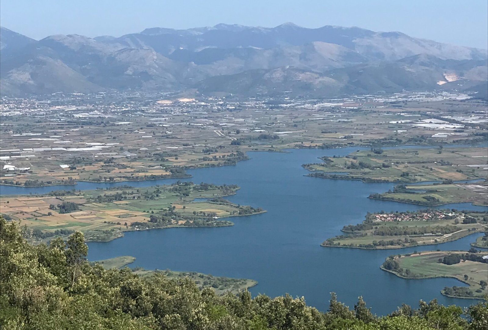
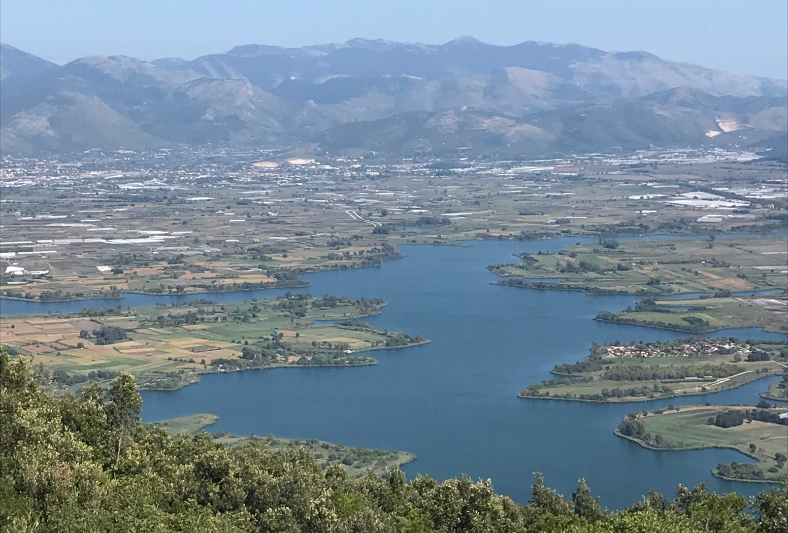
On the plain is Lake Fondi, 700 meters from the sea, connected to the coast by two canals, the Canneto and Sant'Anastasia. Around it, reed beds, woods of water-loving species, semi-flooded meadows and temporary wetlands such as the Pantano Morderei, the Pantano Grande and the Goffa, listed by the body. On the opposite side of the park, in the province of Frosinone, open the Pastena Caves and those of Collepardo, with the Pozzo d'Antullo, which the regional tourism portal places among the main karst complexes in Italy.
The park is not a single place to visit in an afternoon. It is a mosaic of places far from each other, split across two provinces: the Roman temple on the sea at Terracina, the karst field of Campo Soriano, the cork oak grove of Monte San Biagio, the boundary markers above Vallecorsa, the caves of Ciociaria. Anyone who arrives without a precise goal risks spending the day in the car. It's best to pick one sector and stay in it.
On the mountains the dominant woodland is the holm oak forest, the evergreen forest of holm oak, with strawberry tree and some deciduous species such as manna ash, service tree and laburnum, according to the park. On the driest slopes of Monte Calvo and Monte Marino there are sage garigues, elsewhere scrub of ampelodesmos, the large Mediterranean grass. Ferns are very common at the entrance to the caves and in the cracks of the rocks. In spring red valerian colors the cliffs above Terracina.
Among mammals the body lists badgers, porcupines, foxes, stone martens, wild boars and occasionally the wolf. They are elusive animals, more easily met as tracks than in person. Among the birds of prey recorded are peregrine falcon, short-toed eagle, sparrowhawk, hobby, kestrel and buzzard, along with the raven and five species of nocturnal raptors. There are eight amphibians, including the spectacled salamander and the crested newt. Among reptiles the park cites viper, four-lined snake, western whip snake and Aesculapian snake.
At the lake the picture changes. The frequent species, according to the body, are ducks, waders, gray heron, kingfisher, black-winged stilt, marsh harrier and cormorant. To see them you need binoculars, patience and the hours close to dawn. In our judgment, anyone who arrives with these expectations finds at Lake Fondi the most interesting part of the park, much more than someone looking for a postcard landscape. Among moths the body also notes the small emperor moth, whose caterpillar feeds on wild rose or Mediterranean buckthorn.
A curiosity about the Monti Ausoni and Lago di Fondi Park
Inside the park is what the regional portal calls the largest wilderness area in Italy: 4,230 hectares in the municipality of Monte San Biagio. The definition comes from the Italian Wilderness Association and indicates a territory without roads or industrial infrastructure, without houses or permanent buildings, without ski runs or wind farms. It is not a strict reserve closed to the public, but a portion of mountain left as it is, where the only way to move remains the footstep.
Second curiosity, a geological one. At Campo Soriano, between Sonnino and Terracina, isolated limestone towers that geologists call hums stick up from the floor of a karst basin. The tallest is called the Cathedral, for its vertical walls and pinnacles that recall the spires of a Gothic church. It has other names too, collected by the park: Artichoke, Pinnacle, Rock Pyramid, Rava di San Domenico. On the height the body's pages do not agree: one gives 15 meters, two give 18.
Third curiosity: at the Camposoriano visitor center, on Via Camposoriano in Terracina, the park keeps a dinosaur footprint, and the facility's page notes an educational trail dedicated to it under preparation. The operator publishes no opening hours, nor the precise origin of the find. It is a detail that surprises anyone who associates these mountains only with woods and sea: the origin of the carbonate massif of the Ausoni dates back to the Mesozoic, about 200 million years ago according to the body.
The last curiosity concerns the name of the Cathedral. The park says that in a natural niche in the rock remain traces of ancient bricks, a sign that there was a votive image there. The dedication to San Domenico, according to the same source, would come from a Benedictine monk who frequented the area. This is at the level of local tradition: no document published by the body dates the niche or identifies the monk. The shape of the rock, on the other hand, is well explained by karst erosion.
One thing nobody tells you about the Monti Ausoni and Lago di Fondi Park
The body that carries the name of the Monti Ausoni manages much more than the Monti Ausoni. The portal of the Lazio Region attributes to it 20 protected areas, among them the Lake Canterno nature reserve, the Fregellae and Fabrateria Nova reserve, several special areas of conservation and natural monuments. For this reason, among the municipalities linked to the body there also appear Fiuggi and Ferentino, which have nothing to do with the park proper. Anyone looking for information on Lake Fondi has to take this into account.
The contrary position, in our judgment, is this: Lake Fondi is overrated as a destination for a day trip from Rome. The park portal publishes no list of public access points to the shores, and on the lake state-property concessions, professional fishing and farms coexist. The value of the lake is naturalistic, for the migratory birds and for the balance between fresh and salt water. Anyone who arrives expecting a lakeside promenade is disappointed. The lake is better understood from above, from the trails of Monte San Biagio.
Second thing little said: at the body's seat you can enter a garden with remains of the Roman walls. The park writes that the garden of Villa Cantarano is the only green area in the historic center of Fondi open to public use, with a path on native species, a corner tower of the Roman circuit, two stretches of walls and a historic pepper tree. The panels were made by civil service volunteers. The garden's hours are not published: it's best to phone first.
Third thing: even the address of the seat is not uniform across the park's pages. The page for Villa Cantarano gives Via Cavour 46, the page on the garden gives Via Damiano Chiesa 5, and the villa is located right between Piazza Porta Vescovo and Via Damiano Chiesa, up against the walls. The operator does not specify if the two addresses correspond to two entrances of the same complex. For mail and paperwork, Via Cavour 46 applies, given as the seat on all the institutional pages.
What makes Lake Fondi different?
Lake Fondi has been a natural monument since 2006, by decree of the President of the Lazio Region of August 1, 2006, no. 400, amended in 2007. It is part of the European Natura 2000 network as a site of community importance and special protection area, with the code IT6040010, according to the account published by the park. It lies along the Tyrrhenian migration route, and the studies cited by the body have counted more than 100 bird species among nesting, resident and migratory.
The difference from the other coastal lakes of the Pontine plain is the water. The park explains that the lake is fed by many freshwater springs at the foot of the mountains, while seawater enters from the two outlets. The two waters, because of their different density, do not mix: the salt water tends to stay at depth. The result is a transitional environment where tench, roach and stickleback live alongside mullet, eels and sea bass, according to the body's list.
On the numbers the park's pages do not agree. One speaks of a perimeter of about 30 kilometers, another of 32. The average depth is given as 10 meters in one text and as nine meters in another, which adds points down to 21.5 meters. The published surface area also does not match the other measurements. What matters for the visitor is simple: it is a large, shallow lake with very jagged shores.
Among the species the park flags as most valuable is the European pond turtle, a freshwater turtle at high risk of extinction, whose presence at the lake has been confirmed. Among rare birds appear purple heron, crane, stork, osprey, short-toed eagle, ibis and bittern. Among the problems, the body lists alien species such as crucian carp and the red swamp crayfish, along with salinity, eutrophication and waste abandoned on the shores.
My advice for visiting the Monti Ausoni and Lago di Fondi Park
Pick one sector per day. The simplest for anyone coming from Rome is Terracina, where two trails start directly from Piazza Municipio: the 542, called San Francesco or Giove Anxur, leads in 45 minutes to the archaeological area of Monte Sant'Angelo, and the 501 follows upper Via Appia as far as the Epitaffio Tower. Both are classified as hiking trails and passable all year according to the park. You return to town on foot, with no need for a car.
The second sector is Campo Soriano, between Sonnino and Terracina. The 532A variant starts from the Piastre di Sonnino and reaches the karst field in a little under two hours, with 150 meters of climbing. It is the best way to see the hums and the Cathedral, arriving from the woods instead of from the road. The park notes rest points at the Rava and water at the park's forestry station along the route. It's still best to bring your own water.
The third is the real mountain, between Lenola, Vallecorsa and Monte San Biagio, with trails 534, 548 and 535 toward Monte delle Fate. Here the distances grow, the elevation gains exceed 600 meters and services are lacking. On the 540, a loop from Vallecorsa, the park warns that there are no signs, water or refreshment points. It is the most beautiful sector for anyone seeking silence, and the one where a mistake in preparation weighs the most.
Before leaving, download the KML track from the trail's page on the park portal: almost all of them offer it, along with starting coordinates, length and elevation gain. Avoid the hottest months on south-facing slopes, where the limestone holds the heat and shade is scarce. In spring the park notes the blooms of orchids and red valerian on the cliffs. In autumn the chestnut groves of Lenola change color and the light is softer.
Do you pay for anything, do you need to book, and where are the visitor centers?
For the park, no. The territory has no ticket office and the trails are walked freely, without booking. You do pay for some facilities within the perimeter, run with their own rules. The best known are the Pastena Caves, on Via delle Grotte in Pastena, which the park's page says are open every day, holidays included, from 8:30 to 19:00 in summer and from 10:00 to 16:00 in winter. The fee is not given on the page.
For the fee and the tour times of the Pastena Caves the reference is the phone number given by the park, 0776 546322, or the website grottepastenacollepardo.it, flagged by the same page as an official channel along with the park portal. No product dedicated to this park appears on tour booking platforms, and for that reason we don't flag any. For the Temple of Jupiter Anxur in Terracina too, entry should be checked with the municipality before going up.
The body promotes excursions, sports activities and guided visits, and with the GENS catalog offers environmental education programs for schools, along with the Vivi nel Parco series of cultural and recreational events. The calendar is not published on a fixed page: the initiatives come out on the portal and on the body's social channels, on Facebook and Instagram under the name parcoausoni. For an activity with a class it's best to write to the office well in advance.
The park portal lists 15 facilities among offices, visitor centers and museums. In Fondi there are several. The San Domenico complex, on Largo Luigi Fortunato, is today an environmental and cultural hub with a 78-seat auditorium, exhibition rooms, the restored church and the cloister for outdoor events. Villa Placitelli, at Via Gegni 1, covers about 25 hectares with citrus groves, olive groves, archaeological areas and an observation tower on the first floor.
The monastery of San Magno, on Via Valle Vigna, preserves a Renaissance church now dedicated to San Benedetto, with frescoes, a medieval church with scenes from the life of the saint, a guesthouse and a water mill, with a spring that according to the park flows abundantly all year at the foot of the complex. In Fondi the list also includes Palazzo Caetani and the garden of Villa Cantarano, seat of the body. Outside the town are the Camposoriano center and the caves.
For none of these facilities does the portal publish opening hours, except for the Pastena Caves. Don't show up at the gate counting on finding it open. The number to call for all the body's facilities is 0771 513644, given on each page. Among the linked museums the park lists the civic archaeological museum of Castro dei Volsci, the Pio Capponi civic archaeological museum and the Terre di Confine Museum.
Which trails to choose and how demanding are they?
The park portal publishes 20 numbered routes according to the cadastre of the Italian Alpine Club, almost all of difficulty E, that is, hiking. The only one classified T, tourist, is the 530A to Punta Leano, a quarter of an hour's walk. The others range from the 20 minutes of the Fonte San Mauro variant to the more than four hours of the Emilio Selvaggi trail, the 541. The Francigena route, in the Sonnino variant, crosses the park and is listed among the routes.
Three examples with the park's data. The Monte Leano loop, the 530, starts from San Silviano in Terracina: 11 kilometers, 575 meters of elevation gain, three and a half hours, water at the church of San Silviano and near the Madonna di Monte Leano. The 538 from San Silviano to Francolane measures 7.1 kilometers with 480 meters of climbing, and the first stretch of about two and a half kilometers is on paved road. Both are indicated as passable all year.
For the inner mountains, the 534 from Rifugio La Cona to Monte delle Fate measures 5.9 kilometers with 635 meters of climbing and reaches an altitude of 1,090 meters. The park indicates overnight possibilities at the La Cona and Jo Caturo refuges, and water at Jo Caturo, specifying that it is not guaranteed. The 540 loop of Vallecorsa, Quercia del Monaco, Cima del Monte and Acquaviva, measures 9 kilometers with 530 meters of elevation gain and leads to the ruins of the Acquaviva castle.
The signage changes from trail to trail. On many routes the park describes white and red flags outside the paved stretches, on the 530 also red, blue or green paint marks and a yellow and blue disc, on the 540 no marks. Don't take continuous signage for granted as in alpine parks. With the track on your phone, a backup map and a clear idea of the turnaround point, the E trails of the Ausoni remain within reach of people who walk regularly.
Anyone traveling with children or looking for a short walk has two safe options: the 542 of Terracina, 2.1 kilometers almost all downhill to the archaeological area, with a stop at La Fossata park, and the 530A to Punta Leano. For the fit, the most complete combination is Via dei Cippi, the 531, about four hours along the old frontier. The park portal lists it with the 531A Santo Stefano variant, an hour's walk.
Via dei Cippi deserves a couple more lines, because it is the trail that best tells the history of these mountains. According to the park's page it starts from the Epitaffio Tower, at an altitude of 15 meters, and reaches marker number 19 on Monte Romano, at 740 meters. It is 12 kilometers with 945 meters of climbing, about four hours out and three and a half back. Water is found at the Santo Stefano fountain. The declared theme is the boundary markers between the Bourbon state and the papal one.
Two long routes complete the picture. The Emilio Selvaggi trail, the 541, is a 14-kilometer loop that starts and ends at the Terracina cemetery parking lot, with 395 meters of climbing and more than four hours of walking, with no rest areas according to the park. The Francigena variant for Sonnino, on the other hand, connects Fossanova to Monte San Biagio in 22 kilometers, with more than 1000 meters of climbing. The portal gives neither difficulty nor duration, but the numbers are enough to understand that it is a full stage.
What can you do in the park: dogs, fires, fishing, hunting?
Hunting is prohibited. The founding law of 2008 establishes this in article 5, with the sole exception of selective culls and removals necessary to correct ecological imbalances. The same provision refers to the safeguard measures of Regional Law 29 of 1997 on protected areas, which in the zones of maximum protection forbid, among other things, the gathering and damaging of wild flora, except mushrooms and truffles under the rules, the capture of fauna, camping outside equipped areas and motor vehicles off the road.
Fishing is the most delicate topic. The park portal does not publish on its page a regulation that can be consulted by anyone who wants to fish in Lake Fondi. At a conference on August 20, 2021 on the shores of the lake, reported by the body, the director of the park listed among the goals the inclusion of sport fishing in the new regulation and the recognition of official fishing grounds for professionals. Before bringing a rod, ask the office in Fondi what is permitted and where.
For dogs the operator publishes no specific rule. Common sense, in an area with wild boars, foxes and the occasional presence of the wolf noted by the park, suggests a leash, and at the lake also distance from the reed beds during the nesting period. For fires, in 2024 the Lazio Region set the fire-prevention campaign from June 15 to October 15, treating the entire regional territory as an at-risk area. Don't light fires, and for a fire call 112.
The natural monuments within the park, according to the law of 2008, remain subject to their own regulations if more restrictive. This applies to Campo Soriano, the Temple of Jupiter Anxur and the lake. Rock formations are not to be climbed or damaged, fossils and rocks are not to be collected, karst soil is not to be dug. For camping, drone filming, events or organized activities it's best to ask the body first, with a written request to the office in Fondi.
Another well-known fact, yet rarely cited
That these mountains were a frontier many people know. Few know that the frontier can still be seen. According to the tourism portal of the Lazio Region, for centuries the Ausoni acted as a watershed between the Kingdom of Naples and the Papal State. On trail 540 above Vallecorsa the park notes the boundary markers between the Bourbon Kingdom and the State of the Church, and an entire route, the 531, bears the name Via dei Cippi.
The second known and little cited fact concerns the San Vito cork oak grove, in Monte San Biagio. The park defines it as the largest on the Italian peninsula, with an understory of tree heath and rockrose. Less known is that since 2020 the cork oak grove has been at the center of a three-year project of the University of Tuscia, funded by the Lazio Region, against a pathogenic fungus, Phytophthora cinnamomi, according to the body's account. It is a woodland that is being treated.
Third fact: under these mountains open many karst cavities, and the park writes that they host many species of bats, among them the greater and lesser horseshoe bat, the Mediterranean horseshoe bat, Schreibers' bat and Capaccini's myotis. The Pastena caves are classified as through caves, which can be walked from the natural entrance to the underground exit. The entrance hall, according to the park's page, measures 20 meters in height and 12 in width.
The right photo to take at the Monti Ausoni and Lago di Fondi Park
The photo that tells the story of the park is taken from Monte Sant'Angelo, above Terracina, where the Temple of Jupiter Anxur stands. According to the regional tourism portal, from up there the view reaches Circeo, Gaeta and the Pontine Islands. The mountain is the last offshoot of the Ausoni that touches the Tyrrhenian, and the right framing puts together the arches of the sanctuary, the town below and the sea. The best light is that of late afternoon.
The second image is the Cathedral of Campo Soriano, shot with a person next to the base to give the scale of its 15 or 18 meters. The karst field looks good in the raking light of the morning, when the eroded walls cast long shadows on the red soil. Stay on the trails and existing tracks, without climbing on the rocks: the site is a natural monument and a geosite of national importance according to the park.
For the lake the right photo is from above, from the trails that climb above Fondi and Monte San Biagio, to show the jagged shores and the canals toward the sea. In autumn and winter, with the passage of migratory birds, a telephoto lens from the permitted distance lets you photograph herons and cormorants without disturbing them. In the nesting period stay away from the reed beds. The park also notes the black-winged stilt and the kingfisher among the frequent species.
How do you get there from Rome?
By train the reference station is Fondi-Sperlonga, on the Rome-Formia-Naples line, served by regional trains. According to Rete Ferroviaria Italiana the station has a café, waiting room, restrooms, parking with reserved spaces and two platforms reachable by ramp or elevator, but it does not offer the assistance service for people with disabilities. From the station to the trails you need local transport or a car: the park operator publishes no dedicated connections.
For intercity buses between Rome, Latina, Fondi and Terracina the reference is the Cotral website, where you check the day's lines and times. The Terracina trails that start from Piazza Municipio are the most convenient for anyone traveling without a car, because they can be reached on foot from the center. For Campo Soriano, Vallecorsa, Lenola or the cork oak grove of Monte San Biagio a car remains in practice necessary.
By car the reference is Via Appia, which crosses Terracina and Fondi: the park's operations office is at Corso Appio Claudio 11, in the center of Fondi. The starting points of the trails are given with coordinates in the portal's pages, useful to enter in your navigation app. For the Pastena and Collepardo Caves, on the Ciociaria side, the route changes completely and it's best to plan it as a separate day, starting from Frosinone.
Some important events that happened here in history
Around the 4th century BC, when Anxur, today's Terracina, became a Roman colony, a first sanctuary was built on Monte Sant'Angelo, intended according to the park for oracular practice. In 935 AD the San Domenico complex in Fondi is documented, built on the boundaries of the Roman castrum. Of the monastery of San Magno, founded according to tradition in the 6th century, written sources confirm its existence at least from the end of the 10th century, according to the park.
In 1466 Count Onorato II Caetani restored the San Domenico complex, with the square cloister of 23 octagonal and round columns. At the beginning of the 16th century Prospero Colonna, count of Fondi, had San Magno renovated. From the 17th century the monastery declined, and in 1807 it was suppressed with the measure by which Joseph Bonaparte abolished the Benedictine and Cistercian monasteries of the kingdom. For centuries, meanwhile, these mountains marked the border between Naples and Rome.
In 1868 the Pastena Caves were the scene of a siege against followers of brigandage, according to the park's page. In 1926 systematic exploration of the caves began, and during the Second World War hundreds of displaced people found refuge in the underground halls. In 1985 Regional Law no. 56 protected Campo Soriano, the first piece of the future park. In 2000 the natural monument of the Temple of Jupiter Anxur was established, in 2006 that of the lake.
From 2000 the Lazio Region began the restoration and archaeological investigations at San Magno, returning the complex to religious and tourist use. In 2007 Villa Cantarano was restored, destined to be the seat of the body. On December 4, 2008 Regional Law no. 21 established the park. Amendments followed in 2014, 2015 and 2017, and on August 20, 2021 a conference at the Tenuta Sugarelle, on the shores of the lake, discussed the future of fishing.
Who passed through the Monti Ausoni and Lago di Fondi Park
The first names are those of the Roman colonists of Anxur, who built the oracular sanctuary on the mountain above the town, and of the Benedictine monks, tied for centuries to San Magno and to the first phase of the San Domenico complex. According to the park, in the 12th century the Benedictines donated the convent of Fondi to the patriarch San Domenico. At Villa Placitelli, the same source recalls an ancient place of worship dedicated to Isis, later turned into a proto-Benedictine monastery between the 5th and 6th centuries.
Then the lords of Fondi. Onorato II Caetani, count, who in 1466 restored San Domenico. Prospero Colonna, count of Fondi at the beginning of the 16th century, who renovated San Magno. And an illustrious guest: the park writes that Saint Thomas Aquinas often stopped at the convent of San Domenico when he went to visit his sister. It is information the body reports without indicating the documentary source, and it should be read as convent tradition more than as a dated fact.
The 19th century brings Joseph Bonaparte, who in 1807 suppressed San Magno, and the brigands besieged in the Pastena Caves in 1868. The 20th century, the speleologists of 1926 and the displaced of the war. The latest arrivals are the researchers of the University of Tuscia at work on the cork oak grove, the professional fishermen and the civil service volunteers who wrote and recorded the panels of the garden of Villa Cantarano. The park has also become a place of study.
What remains of the border between the Papal State and the Kingdom of Naples?
What the documents published by the body say: over the Monti Ausoni ran the border between the Papal State and the Kingdom of Naples, and along trails 531 and 540 remain the markers that marked it, indicated by the park as the boundary between the Bourbon Kingdom and the Papal State. Marker number 19 on Monte Romano is the end point of Via dei Cippi. The Epitaffio Tower, the starting point of the same trail, is also the end of the 501, the upper Via Appia trail that climbs from Terracina.
What tradition says: around every mountain frontier, tales of smuggling and brigands arise. Here there is a documented trace: the park's page on the Pastena Caves recalls the siege of 1868 against followers of brigandage. The rest of the tales about hiding places and treasures belongs to legend, and no official page confirms it. On the theme of brigandage between Lazio and Abruzzo, on the site you will also find the Cammino dei Briganti.
What can you see today? Numbered stone markers, as the name of marker 19 on Monte Romano says, scattered along the old route. The operator indicates no explanatory panels on the individual markers, and on the 540 the park warns that signage is missing. To find them you need the KML track downloaded from the page and a bit of patience. The advice is to photograph them without moving anything and without cleaning the stone: they are historic artifacts inside a protected area, not souvenirs. Their value is to stay exactly where they were placed.
When is it closed and what not to expect?
The territory of the park does not close. What closes, or can be closed, are individual trails after landslides, fires or logging, and the facilities outside their hours. The operator publishes no bulletin of passable trails. After heavy rain or in periods of fire-risk alert it's best to call the office in Fondi or check the notices on the park portal and on its social channels before leaving.
What not to expect? A visitor center always open with maps and staff. Uniform signage: on the 540 there is none. Water along the route: on many trails it is missing or not guaranteed. A staffed refuge with hot meals: the park indicates overnight possibilities at the La Cona and Jo Caturo refuges, but no refreshment points. An equipped lakefront in Fondi: the body's pages describe none.
Don't expect a high-mountain park either. The maximum altitudes stay below 1,200 meters, and in summer the heat on the sun-exposed limestone slopes is the real limit, more than the effort. In winter snow is rare but the inner trails can be muddy. The park notes almost all trails as passable all year, but this does not mean they are equally pleasant in every season.
One last warning concerns the phone. In the inner valleys, between Vallecorsa, Lenola and the Monte San Biagio wilderness area, coverage can be missing for long stretches, and the park notes trails with no rest areas or support points. Before leaving, give someone your itinerary and expected return time, download the track and the map in offline mode, bring a spare battery. For emergencies the number remains 112.
Eating in the area
Inside the park refreshment points are rare and on the mountain trails, according to the pages, they are missing entirely. Lunch therefore has to be organized in the towns of departure or carried in the backpack. Fondi is known for the blond orange and the territory, according to the regional tourism portal, produces buffalo mozzarella, extra virgin olive oil and historic wines such as Cecubo. These are products to look for in the local markets and shops, not in places built for passing tourism.
The traps are concentrated on the coast, between Terracina and Sperlonga, especially in summer. The signs are always the same: the barker on the sidewalk, the menu with photographs of the dishes, items with no price, a different menu outside and inside, the kitchen open nonstop with no break. Those who live here avoid these places because they live off passing trade and not regular customers, and the quality adjusts accordingly.
The practical rule is to choose where you see local people at the lunch break, with a short menu, handwritten or printed every day, and clear prices. In the inland towns, from Lenola to Vallecorsa, it's not wise to count on a kitchen open in the middle of the afternoon: after a long hike the packed lunch remains the safest choice. To find addresses selected with care there is the list of addresses on Google Maps.
What to combine in a day
The most convenient base is Fondi, with the medieval center inside the perimeter of the Roman walls, the San Domenico complex and Palazzo Caetani. From there the coast is close. Sperlonga has the Villa of Tiberius with the national archaeological museum and beaches such as the Fontana beach. Terracina combines the Temple of Jupiter Anxur, Via Appia and the historic center.
Toward the interior, the park's villages deserve a stop: Sonnino, which gives its name to the Francigena variant between Fossanova and Monte San Biagio, and Lenola with its chestnut groves. A little farther south are Itri and Campodimele, at the edge of the Aurunci. Anyone following the pilgrim route can read the page on Via Francigena in Lazio, useful for understanding how the Sonnino variant joins the route.
On the Ciociaria side the park touches Collepardo, with the caves and the Pozzo d'Antullo, and the nearby Certosa di Trisulti. Farther east you reach the Falvaterra and Rio Obaco Caves, Pico and Lake Posta Fibreno, another spring-water reserve. Toward the north, the Pontine plain leads to Priverno, to the Privernum archaeological park and to Fossanova Abbey.
On the coast to the north are Circeo National Park, Sabaudia, San Felice Circeo and Lake Fogliano, to compare with Lake Fondi. To the south, the Riviera di Ulisse with Gaeta, Formia and the Gianola and Monte di Scauri Park. Anyone with a few more days can add the island of Ponza, checking the season's sea connections.
For anyone looking for other small lakes in the province of Latina there are the Gricilli Lakes, and for another Cistercian abbey in the mountains there is Valvisciolo Abbey. The calendar of the province's town festivals is on the page about food festivals and feasts in Lazio, to be checked before choosing the date of the hike.
Frequently asked questions
Do you pay to enter the Monti Ausoni and Lago di Fondi Park?
No. The park is an open territory of 11 municipalities between Latina and Frosinone, with no gates and no ticket office, and the CAI trails published by the body are walked freely. You pay only for some facilities within the perimeter, such as the Pastena Caves, which the park's page says are open every day with summer and winter hours. For the cave fee the number given is 0776 546322.
Where is the park's seat and how do you contact it?
The body's seat is at Villa Cantarano, Via Cavour 46 in Fondi, up against the city walls, with an operations office at Corso Appio Claudio 11. The phone is 0771 513644, the email parcoausoni@regione.lazio.it, the PEC parcomontiausoni@pec.regione.lazio.it. The operator publishes no office hours, so it's best to phone before showing up, especially to ask for permits or information on the trails.
Which is the easiest trail to start with?
The easiest is the 530A to Punta Leano, classified as tourist and a quarter of an hour long. For a more complete first hike, the 542 of Terracina starts from Piazza Municipio and reaches the archaeological area of the Temple of Jupiter Anxur in 45 minutes, with 2.1 kilometers almost all downhill. The park indicates it as passable all year, also by bicycle, with water at the fountain of Piazza Santa Domitilla.
Can you bring a dog to the park?
The operator publishes no specific rule for dogs on the park's pages. In the area live wild boars, foxes, badgers, porcupines and, occasionally, the wolf, according to the body, and protected birds nest at the lake. For this reason the advice is to keep the dog on a leash on all trails and away from the reed beds. For precise rules on individual zones, especially in the natural monuments, it's best to ask the office in Fondi.
Can you fish in Lake Fondi?
The park portal does not publish a fishing regulation that can be consulted. Professional fishing operates on the lake, and in 2021 the director of the body listed among the goals the inclusion of sport fishing in the new regulation, according to the account of a conference published by the park. The lake is a natural monument and a Natura 2000 site, so before fishing it is essential to ask the body's office what is permitted, where and with what permits.
Can you light fires or have a barbecue?
The operator publishes no specific rules on fires, but the park is largely covered by woods and Mediterranean scrub. In 2024 the Lazio Region set the fire-prevention campaign from June 15 to October 15, treating the entire regional territory as an at-risk area during the period of maximum danger. The advice is never to light fires in the park. To report a fire, call the single emergency number 112.
What is the Cathedral of Campo Soriano?
It is the largest of the hums of Campo Soriano, isolated limestone towers that rise from the floor of a karst field between Sonnino and Terracina. The name comes from the vertical walls and pinnacles that recall a Gothic church. On the height the park's pages do not agree, 15 or 18 meters. It is reached with the 532A variant from the Piastre di Sonnino, and the Camposoriano visitor center is nearby.
How much time do you need to visit the park?
The park can't be visited in a day. It is a territory of almost 13,000 hectares with sectors far from each other, from the sea at Terracina to the caves of Ciociaria. One day is enough for one sector: Terracina with the Temple of Jupiter Anxur, or Campo Soriano, or a mountain hike toward Monte delle Fate. To see the lake, cork oak grove, caves and mountain you need at least three days, based in Fondi.
Who wrote this and from what sources
The text comes from the editorial team of Tour Leader Pro, the Rome-based company that designs itineraries, visits and cultural events in Rome and Lazio. The fees, hours and access details given here come from the official sources cited in the text as of the date indicated at the top: for the park, the authorities are the body's portal on the Lazio parks website and Regional Law no. 21 of 2008. Tell us what you find changed.
Organizing an outing in the Ausoni for a group means working on logistics more than on tickets: choosing a single sector, calculating the driving times between starting points, checking for water along the trail, asking the body about any permits and the hours of the visitor centers. For anyone planning outings of this kind, a useful resource for those who organize group trips is Tour Leader Pro, with tools designed to coordinate visits and itineraries.
The park is also a gateway to the less-traveled southern Lazio, made of limestone mountains, coastal lakes, Cistercian abbeys and Roman towns along Via Appia. Putting together the Ausoni, Circeo, the Riviera di Ulisse and the caves of Ciociaria takes a few days and a bit of planning, and a useful resource for putting together a multi-day itinerary is Italy Planner.